
Kendrick Mountain Trail #22
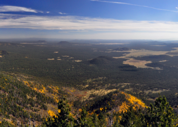
This is a hike to one of the highest vistas in northern Arizona. From Kendrick's 10,418 foot summit, you can see the Grand Canyon to the north and Oak Creek Canyon to the south. In addition to the impressive scenery, it's a good place to see wildlife, especially elk and mule deer.
The trail starts in the ponderosa pines and climbs into the mixed conifer forests of Douglas fir, white fir, Engelmann spruce and corkbark fir within the Kendrick Mountain Wilderness. Note that there are no reliable springs along the trail and no water at the top of the mountain. Just below the mountain's summit, you'll see an old cabin. This is the old lookout cabin, built in the early 1900s and listed in the National Register of Historic Places.
After about 1/2 mile of trail, this route up Kendrick Mountain follows an old fire road for about one mile. From this point the trail becomes a foot path again and is well marked and gently sloped. Almost all of the trail is within the Kendrick Mountain Wilderness.
To see some beautiful fall colors select the Fall Colors for the Williams District album on our Flickr photo site for what you see on Kendrick Mountain Trail as well as other great places.
Specific Trail Information
Trail Number
Trail Type
Getting There
Trailhead/Starting Points
Forest Road 190
Directions
From Williams (approximately 26.7 miles):
- Begin from Williams on I-40 east for approximately 14.4 miles to the Parks exit #178,
- Turn left onto N Park Rd and follow for approximately 0.2 miles,
- Turn right onto E Old Route 66 and follow for approximately 1 mile,
- Turn left onto N Government Prairie Road and follow for approximately 6.2 miles,
- Turn right onto Forest Road 100 and follow for approximately 4.1 miles,
- Take sharp left onto Forest Road 171 then take immediate right onto Forest Road 190 and follow for approximately 0.4 mile to the trailhead.
Road Condition: Paved road and all-weather graveled road suitable for passenger vehicles.
Recreation Groups
Shared with the Coconino National Forest, the Kendrick Mountain Wilderness encompasses Kendrick Peak, one of the many pea