
Pumpkin Trail #39
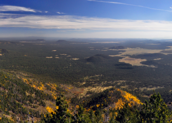
The Pumpkin Trail offers the visitor a long hike from a valley of pine and junipers up through mountain meadows and forests of mixed conifer, aspen and fir to the summit of Kendrick Peak. All of the hike is within the Kendrick Mountain Wilderness. The upper three quarters of it follow the alignment of an old sheepherder route used up to 40 years ago. The remains of an old sheepherder's cabin still stands alongside the trail about 1/4 mile below the lookout tower. Note that there are no reliable springs along the trail and no water at the top of the mountain.
Initially, this trail follows an old road then rises along a steep canyon. After passing through a gate, the trail ascends a ridge, gradually turning southeast. From here to the top of Kendrick
Mountain, the trail follows a ridge through meadows, aspen and conifer stands. Rock cairns often show the way. All of the trail is within the Kendrick Mountain Wilderness.
It is possible to link up with the Bull Basin Trail via the Connector Trail for an 11 mile hike.
Specific Trail Information
Trail Number
Trail Type
General Information
None. Bring everything you will need.
No motorized or mechanized vehicles (e.g. mountain bikes.) Hiking and horseback riding only.
Getting There
Trailhead/Starting Points
End of Forest Road 149
Directions
From I-40 exit #178 in Parks (approximately 16.2 miles):
- Begin north on N Parks Rd for approximately 0.2 mile,
- Turn left onto E Old Route 66 and follow for approximately 0.6 mile,
- Turn right onto N Spring Valley Rd and follow for approximately 10.4 miles,
- Continue onto Forest Road 144/Pumpkin Center Rd and follow for approximately 1.8 miles,
- Bear right to continue on Pumpkin Center Rd (becomes Forest Road 171) and follow for 1.8 miles,
- Continue straight on Forest Road 171 for approximately 1.1 miles,
- Turn left onto Forest Road 149 and follow for approximately 0.4 mile to the trailhead.
Road Condition: Paved road, all-weather graveled road, and a few miles of unsurfaced road that is suitable for passenger vehicles only when the weather is dry.
Recreation Groups
Shared with the Coconino National Forest, the Kendrick Mountain Wilderness encompasses Kendrick Peak, one of the many pea