
Yellow Aster Butte Trail 686.1
The Yellow Aster Butte Trail is within Mt. Baker Wilderness. Find various wildflowers such as anemone, aster, paintbrush and fireweed along the trail in summer. In late summer and early fall blueberries are ripe for the picking, followed by brilliant red foliage. Interesting rock formations from the Yellow Aster Complex, carved by glaciers and worn by weather, give the trail its name. Enjoy spectacular views of Mt. Baker, Mt. Tomyhoi, American and Canadian Border Peaks, Mt. Larrabee, and more. You may see marmots, pikas, mountain goats, and a varitey of birds. It is approximately 4 miles and 2500' elevation gain, one-way to trail end on the false summit of Yellow Aster Butte (6178' elevation).
Start on Tomyhoi Lake Trail 686 , switchback through an avalanche path, then enter the forest and continue gaining elevation until the trail breaks out to a flat bench in a meadow. The junction with Yellow Aster Butte Trail 686.1 is about mile and a half from the trailhead. Turn left at the junction and contour around the south side of Yellow Aster Butte.
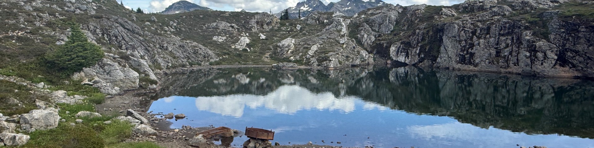
At 3.6 miles from the trailhead, reach an unsigned junction. The trail to the right continues approximately a half mile and 400 feet elevation to the windy summit of Yellow Aster Butte. The trail to the left descends 200 feet on a series of steep switchbacks and narrow tread to the designated camping area, where glaciers have carved numerous, small tarns (lakes). Sharp-eyed hikers can find evidence of past mining activity. Camp on snow, rock or bare ground; the meadows are extremely fragile. Beyond the tarns are unmarked cross-country routes to High Divide and Tomyhoi Peak.


Specific Trail Information
Trail Number
Trail Type
General Information
Black bears frequent the area. Food and scented items need to be stored in a secure manner.
There are camping restrictions for this trail. Please see restrictions section.
• Green Trails: Mt. Shuksan #14 and Mt. Baker Wilderness 13SX
• USGS: Mount Larrabee
• USFS: Mt. Baker Ranger District and Mt. Baker Wilderness.
Summer - Fall
There is no permit required for hiking or camping but a valid Recreation Pass must be displayed in vehicles at Tomyhoi/Yellow Aster Butte Trailhead.
Please note that the Washington State Discover Pass is not accepted at Forest Service fee sites.
There is no permit required for hiking or camping but a valid Recreation Pass must be displayed in vehicles at Tomyhoi/Yellow Aster Butte Trailhead.
Please note that the Washington State Discover Pass is not accepted at Forest Service fee sites.
No potable water.
Open to hikers only.
No campfires. No camping within one mile of Yellow Aster Butte Trail, except at the tarns. Trail enters Mt. Baker Wilderness. Wilderness regulations apply.
It is required to keep food and scented items secure from wildlife by keeping a clean camp and store those items in your vehicle or use a product approved by the Interagency Grizzly Bear Committee such as an ursack or wildlife resistant storage canister. You can also hang food and scented items at least 10 feet off the ground and 4 feet from the trunk and all branches.

Address: 10091 Mt. Baker Highway Glacier, WA 98244
Phone: (360) 599-2714
Hours: All passes and permits available at this location. Friday-Sunday 8 - 4:30, Monday-Thursday CLOSED. Seasonal hour change: Saturday and Sunday only, 9 a.m.-3 p.m. after 9/28. (Closed on federal holidays)
Getting There
Parking
Parking is roadside along the switchbacks above and below the trailhead. Do not block the bathroom and please do not park on the inside of the switchbacks and make sure there is enough room for a large emergency vehicle to get through.
Directions
From Glacier, WA travel east on Mt. Baker Highway SR 542 for about 12 miles. Then turn left ontoTwin Lakes Road (Forest Service road 3065). The road is located at the east end of the Department of Transportation's Shuksan maintenance facility. After 4.5 miles on Forest Service road 3065, reach the Tomyhoi Lake/Yellow Aster Butte Trailhead and parking area.
Additional Information
Operated By
US Forest Service