Current River
The Current River is part of the Ozark National Scenic Riverways. Our site provides information on the USDA Forest Service operated sites along the river. For information on the National Park Service operated sites please visit the NPS website for Ozark National Scenic Riverways.
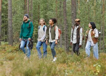
The Current River provides a wonderful opportunity for the public to experience a more social recreation opportunity in the southern Ozarks. On weekends you will experience numerous recreationists enjoying a variety of water-based activities.
The swift, clear and cool Current River with numerous gravel bars provides motorized boating, non-motorized boating, tubing, camping, picnicking and wading opportunities in a more pristine recreation setting.
A favorite past time on the river, whether boating or tubing, includes taking breaks on the numerous gravel bars.
The recreation areas on the Current River are easily accessible by vehicle and are located near small communities which provide a variety of services.
From Watercress, and down the river you’ll see a mix of Park Service, Forest Service, and private lands. Occasionally you’ll pass by a hayfield.
The channel of the river meanders yearly, and a gravel bar you visited last year may no longer exist this year. The river does have trees down along the way so boaters will need to be aware of submerged objects as they travel.
For Stream Flow and Flooding forecast visit the USGS website.
Photos of the Current River


General Information
Campground Camping
- Deer Leap Recreation Area
- Float Camp Recreation Area
- Watercress Recreation Area
Deer Leap Recreation Area
This campground has 7 sites. Amenities include: drinking water, vault toilet, picnic tables, fire rings and lantern posts. Semi-private sites, most sites have spacing and vegetation between them. All sites are within walking distance of the river.
Float Camp Recreation Area
This is a large, open campground with little privacy screening between the 20 campsites. While there's not much solitude, but you'll enjoy level, roomy campsites and have a good opportunity to socialize with adjacent campers. Trash cans or dumpsters and vault toilets are centrally located. No sewage disposal is available.
Watercress Recreation Area
Watercress Campground has 17 sites and lies on the banks one of the forest’s greatest treasures; the Current River. Floats on the river provide views of southeastern Missouri that otherwise can't be seen. The area is home to a variety of birds and wildlife and recreation opportunities are plentiful in the surrounding area.
January - December
Pass information can be found on the Passes and Permits page of the website.
When you visit, please remember
- No glass on the river
- Poly-styrene is highly discouraged on this river
- You can camp along the river as long as you are on public land
- Check weather conditions and river levels before visiting, conditions can change quickly.
- Please remember to Leave No Trace (link to site)
- Please be respectful of private property along the river.
Day Use Fees
- Deer Leap Recreation Area – Forest Service
- Float Camp Recreation Area - concession
Campground Fees
- Deer Leap Recreation Area – Forest Service
- Float Camp Recreation Area – concession
- Watercress Recreation Area – Forest Service
There is a 50% discount for camping for anyone with an Interagency Access or Senior Pass. Interagency passes cover the full day use fees
When boating with your dog, follow all Missouri State boating laws and only allow your animal on pet-friendly shorelines.
- Use care when getting your dog in and out of the boat to ensure their safety.
- Consider both you and your dog wearing a life jacket.
- Provide shade for your pet.
- Remember to bring their food and water as it may be unsafe for them to drink lake water.
- Occasionally, bring your dog to land so that they can relieve themselves.
Please remember that dogs are prohibited in designated swimming areas.

Address: #66 Confederate Ridge Road Doniphan, MO 63935
Phone: 573-996-2153
Hours: 8:00 am - 4:30 pm, Monday to Friday; District Offices closed 1 - 1:30 for lunch (Closed on federal holidays)
Office Email: sm.fs.marktwainnf@usda.gov
Getting There
Directions
The river is located in the Southern part of Missouri in the Ozark foothills. See specific recreation areas on the Current River for directions.
Parking
There is parking at: Bay Nothing, Deer Leap, Float Camp, Watercress
Facility and Amenity Information
Accessibility
Bay Nothing
Toilet is wheelchair accessible.
Deer Leap
tables, fire rings, toilets, pedestal grills are accessible
Float Camp
Tables, fire rings, pedestal grills, lantern posts, water faucets and toilets are all accessible. There are sidewalks at the day use area.
Watercress
The tables, grills and fire rings are accessible
Restrooms
Restrooms are not available at this site.
Restrooms are available at: Float Camp, Deer Leap, Watercress, Bay Nothing
Water
Potable water is available at this site.
Water is available at: Float Camp, Deer Leap, Watercress
Picnic Tables
Picnic tables are available at this site.
Float Camp, Watercress
Horse/Pack Animal Information
Horse/Pack animals are allowed at this site.
Horseback riding is available in the Current River Section of the Ozark Trail.
Recreation Opportunities
Picnicking - Single Info
Places with picnic tables along the river:
- Float Camp Recreation Area
- Watercress Recreation Area
Float Camp Recreation Area
The picnic area is downhill from the picnic pavilion, on the banks of the Current River. Picnic tables, pedestal grills, and trash receptacles. There are vault toilets up the hill near the pavilion.
Watercress Recreation Area
There are five individual picnic sites throughout the recreation area. Amenities available are: Picnic tables, pedestal grills, trash receptacles, drinking water, flush toilets.
Picnicking - Groups Info
Float Camp Recreation Area
The picnic pavilion is adjacent to the parking area, shaded by tress on the side of a slope at the top of the hill from the swimming area. The pavilion is a great place for views of the river!
No. of Sites
1 pavilion, accommodates up to 75 people.
No. of Accessible Sites
tables and grill are accessible
Watercress Recreation Area
The picnic pavilion is adjacent to the parking area, shaded by tress on the side of a slope at the top of the hill from the swimming area. The pavilion is a great place for views of the river!
Day Hikes Info
Hiking opportunities along the Current River
- Float Camp Recreation Area
- White Oak and Wood Chuck Trails
- OT - Current River Section
- Watercress Recreation Area
- Songbird Hike
Current River Section of the Ozark Trail - 30 miles
The Current River Section of the Ozark Trail, a 30 mile section, passes through a myriad of publicly owned lands, best viewed from the trail atop Stegal Mountain, the highest point in the area. The trail wanders through Peck Ranch Conservation Area. High bluffs, shut ins and igneous glades provide attractive scenery.
Woodchuck and White Oak Trail - 1.5 miles
Woodchuck Trail is a half mile long trail connecting Float Camp Picnic Area with the campground. White Oak Trail is a 1.5-mile loop trail originating at the Float Camp Picnic Area's parking lot.
Songbird Trail - .86 miles
Songbird Trail, a .86 mile trail begins in an open, grassy area between campsites #11 and #12, Watercress Spring is just at the start of the trail near the campsites. From the spring the trail climbs up a hillside, from there you go south to the Watercress entry road. You follow the road back to the campground to make a loop.
The boardwalk crosses a creek, that is part of the Watercress Spring, by the boat ramp will lead to the beach access.
A range of habitats along the trail, from wooded uplands to riparian area. The remains of Civil War earthworks can still be seen high on a hill that overlooks Current River.
Backpacking Info
Hiking opportunities along the Current River
- Float Camp Recreation Area
- White Oak and Wood Chuck Trails
- OT - Current River Section
- Watercress Recreation Area
- Songbird Hike
Current River Section of the Ozark Trail - 30 miles
The Current River Section of the Ozark Trail, a 30 mile section, passes through a myriad of publicly owned lands, best viewed from the trail atop Stegal Mountain, the highest point in the area. The trail wanders through Peck Ranch Conservation Area. High bluffs, shut ins and igneous glades provide attractive scenery.
Woodchuck and White Oak Trail - 1.5 miles
Woodchuck Trail is a half mile long trail connecting Float Camp Picnic Area with the campground. White Oak Trail is a 1.5-mile loop trail originating at the Float Camp Picnic Area's parking lot.
Songbird Trail - .86 miles
Songbird Trail, a .86 mile trail begins in an open, grassy area between campsites #11 and #12, Watercress Spring is just at the start of the trail near the campsites. From the spring the trail climbs up a hillside, from there you go south to the Watercress entry road. You follow the road back to the campground to make a loop.
The boardwalk crosses a creek, that is part of the Watercress Spring, by the boat ramp will lead to the beach access.
A range of habitats along the trail, from wooded uplands to riparian area. The remains of Civil War earthworks can still be seen high on a hill that overlooks Current River.
Boating - Motorized Info
Boat ramps along the river are located at:
- Bay Nothing Gravel Boat Launch
- Deer Leap Recreation Area
- Watercress Recreation Area
Please check ahead for river conditions for the section you plan to visit ahead of time.
Find more information on Ozark National Scenic Riverways on the National Park Service website.
From To Miles
Watercress (FS) to Big Spring (NPS) 4.9 miles
Big Spring (NPS) to Hickory Landing (NPS) 8.6 miles
Hickory Landing (NPS) to Cataract Landing (NPS) .2 miles
Cataract Landing (NPS) to Gooseneck (NPS) 6.2 miles
Gooseneck (NPS) to Bay Nothing (FS) 1.6 miles
Bay Nothing (FS) to Deer Leap (FS) 15 miles
Deer Leap (FS) to Float Camp (FS - no launch) 1 miles
Float Camp (FS - no launch) to Doniphon city (Township) 5 miles
Type of Craft
Fishing Boats, Dinghies, Electric Boats, Flat Boats, Jon Boats
Size Restrictions
None
Motor Type
gas, electric
Boating - Non-Motorized Info
Please check ahead for river conditions for the section you plan to visit ahead of time.
Find more information on Ozark National Scenic Riverways on the National Park Service website.
A mileage chart is available under motorized boating.
Swimming Info
Watercress Recreation Area
There is a beach access to the south/left side of the boat ramp. Throughout the day use area there are two concrete river access areas that have stairs, with railings, leading to the beach. The sidewalk to the stairs is made from pavers.
The river is immediately deep at the concrete at the access to the right. This access may not be suitable for wading.
The river is very popular with boaters, so be aware of other traffic on the river if/when you are wading.
Tubing
- Bay Nothing Gravel Boat Launch
- Deer Leap Recreation Area
- Watercress Recreation Area
Deer Leap Recreation Area
Canoes, kayaks and other non-motorized boats may be launched at the concrete Deer Leap Boat Launch, or carried down at the floater/tuber access.
The Tuber Launch is being operated at the end of the campground, and is a popular put-in for floating the Current River. This access is also shared with outfitter/guides.
Fishing - River/Stream Info
Boat ramps available at: Bay Nothing, Deer Leap, Float Camp, Watercress
The clear and cool Current River between Doniphan, MO and Van Buren MO, provides both motorized and non-motorized fishing opportunities thru are a variety of access points.
Fishing permits are available from Missouri Department of Conservation
Fish Species
Bass, Panfish
Special Designations
None
Fishing Mode
Bank, Private Boat
Fishing Platform
None
Cleaning Station
None
Accessible Platform
None
Water Temperature
45-70 Degrees
Fishing Method
Rod & Reel
Water/Flow Level
1-8 feet
Difficulty Level:
Easy
Horseback Riding Info
Current River Section of the Ozark Trail - 30-miles
The Current River Section of the Ozark Trail, a 30 mile section, passes through a myriad of publicly owned lands, best viewed from the trail atop Stegal Mountain, the highest point in the area. The trail wanders through Peck Ranch Conservation Area. High bluffs, shut ins and igneous glades provide attractive scenery.
Recreation Groups