
Glade Top National Forest Scenic Byway
Welcome to Glade Top Trail, a National Forest Scenic Byway in Missouri!
This 23-mile Scenic Byway is named for the beautiful glades that surround the ridge tops where the Scenic Byway traverses.
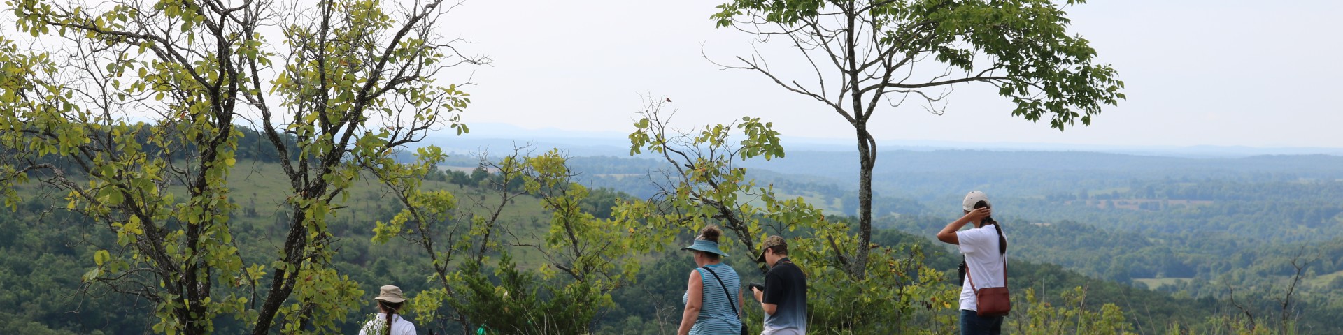
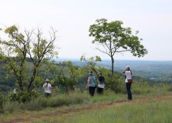
Along the trail are seven overlook “pull-outs” that provide panoramic views that reach to the Springfield Plateau twenty miles to the northwest and forty miles south to the Boston Mountains in Arkansas. Visit the detail stop links below for more about each of the views.
The Glade Top Trail is little changed from the original road constructed by the Civilian Conservation Corps in the late 1930’s. For twenty-three miles, the two-lane, all weather gravel road follows narrow ridge tops rising approximately 500 feet above the surrounding rolling countryside, and overlooks and passes through many limestone/dolomite glades interspersed with open and closed woodlands.
Fun Fact:
People have been using the word glade since the 1500s. The term was often used, not just to indicate a clearing in the woods, but one filled with sunlight.
According to Merriam-Webster dictionary the word Glade is defined as “an open space surrounded by woods”. It is thought to come from the adjective glad, which also meant “shining”.
Hence, glades in Missouri are sunshine filled openings in a vast forested area.
!AGENTS OF DISCOVERY MISSION SITE!
The Glade Top Trail has a secret mission for kids (or adults) to play when visiting! Download the Agents of Discovery app to your mobile device, search for the Caney Picnic Area Glade Top Trail in the available missions and have some extra fun when visiting this day use area.
More on how to how to use the app
Stops Along the Byway
- Haden Park
- Smoke Tree Scene
- Arkansas View
- Watershed Divide
- Caney Picnic Area
- Willie Lee/Wolf Junction
- Big Creek Basin
- Panorama
- McClurg Glade
What is a glade?
Glades are a type of grassland habitat, dominated by warm-season grasses and drought-adapted forbs (wildflowers). They are characterized by shallow soils and rocky outcrops, usually occurring on southwest or western slopes. Glades are found on chert, dolomite, igneous, limestone, and sandstone bedrock.
Along Glade Top Trail dolomite is the primary bedrock formation, which makes calcium-rich soils, contributing to the types of grasses and wildflowers found here.
Why is a glade special?
More than 500 species of native plants are found in Missouri’s glade habitats. Many of these species can be found in other grassland communities like tallgrass prairies and savannas, but a significant number of these species only grow on glades. Some of Missouri’s rarest plant species are glade dependent.
The patchwork of glades and woodlands across this landscape provides a mosaic of resources for wildlife to utilize during different times of the year, and during different life stages. Wild turkeys, bobwhite quail, and neo-tropical birds find an abundance of nesting, brooding and feeding areas in and along the edges of glades.
You will also find important pollinators such as bees, butterflies, moths, wasps, flies, beetles, ants, and hummingbirds on the glades. Because of the shallow, rocky soils and virtually shade less environment of glades, they resemble desert environments in many ways. Desert wildlife such as roadrunners, collared lizards, tarantulas, and scorpions are found in our glades as well.
Why are Ava glades very special?
The glades along Glade Top Trail are some of the largest glades in the United States under conservation management. Mark Twain National Forest has over 44,000 acres of glades on its public lands, and the Ava area has 26,708 of those acres.
Currently, 8,709 glade acres in the Ava area are under conservation management including prescribed fire and other restoration practices. The quality of the natural habitat has been enhanced, or maintained to promote and protect the high biodiversity of this special natural community.
Photos of Glade Top National Forest Scenic Byway


General Information
Camping
Dispersed camping is allowed at Willie Lee, please note there are no fire rings or tables available.
Dispersed camping is the term used for free camping anywhere in the National Forest OUTSIDE of a designated campground.
Dispersed camping means there are no toilets, no structures, no trash cans, no treated water, and no fire grates.
When visiting:
- Pick a Campsite and follow the Leave No Trace Principles
- Camp 100 feet away from trails and water sources.
- Treat any water found in the area before consuming it.
- Human waste (Feces) must be buried at least 6 inches deep and covered.
- Pack out all of your garbage.
January - December
Special Use permits are needed at Caney Day Use Area for events with 75 people or more.
You will need a county permit for riding ATVs/UTVs on the byway
No sites along the byway charge a day use fee.
When at stops please keep your dog on a 6-foot (or shorter) leash. Don't forget to bring waste bags to clean up after them.
None of the stops have drinking water so make sure to bring enough water (and snacks!) for your furry companion.

Address: 1006 S. Jefferson Ava, MO 65608
Phone: 417-683-4428
Hours: 8:00 am - 4:30 pm, Monday to Friday; District Offices closed 1 - 1:30 for lunch (Closed on federal holidays)
Office Email: sm.fs.marktwainnf@usda.gov
Getting There
Directions
From Ava, MO
The byway begins outside of Ava:
- go south on Hwy 5 for three miles to Hwy A
- turn right/west on Hwy A and drive 4 miles to Smallett Junction,
- turn left/south on A409 and Hayden Park, the first stop on the byway is on the right.
- To continue on the byway from Hayden Park, stay on A409 until Forest Road 147.
- At the junction of Forest Roads 147 and 149
- stay on Forest Road 147 and come out at Longrun, MO or
- turn right onto Forest Road 149 and travel until the gravel road ends at Highway 125.
Parking
All sites along the byway have parking available
Facility and Amenity Information
Accessibility
Caney Day Use Area
Vault toilet is accessible
Arkansas View
Picnic table and horse hitch
Restrooms
Restrooms are not available at this site.
Water
Potable water is not available at this site.
No stops along the byway have potable water
Picnic Tables
Picnic tables are available at this site.
Arkansas View; Willie Lee/Wolf Junction; Haden Park; Caney Day Use Area;
Nearby Trails
Recreation Opportunities
Picnicking - Single Info
Stops where you can picnic:
- Stop 1: Haden Park
- Stop 3: Arkansas View
- Stop 5: Caney Day Use Area
- Wolf Junction (GTT Stop 7)
Caney Day Use Area
Located along the Glade Top Trail National Forest Scenic Byway, this day use area is situated on one of the Ozark glades.
In the day use area there are several picnic tables on a 30x40 foot concrete pad that you get to on a hard-packed dirt trail from the parking area. There is one grill shared by all the tables.
The amphitheater is down several rock steps and slopes down. The amphitheater can seat between 75 – 100 people. Wooden benches are provided or you can bring your own chair.
Picnicking - Groups Info
Caney Day Use Area
Located along the Glade Top Trail National Forest Scenic Byway, this day use area is situated on one of the Ozark glades.
In the day use area there are several picnic tables on a 30x40 foot concrete pad that you get to on a hard-packed dirt trail from the parking area. There is one grill shared by all the tables.
The amphitheater is down several rock steps and slopes down. The amphitheater can seat between 75 – 100 people. Wooden benches are provided or you can bring your own chair.
Scenic Driving Info
Stretching 23 miles over Missouri's Ozark hill country, the Glade Top Trail weaves along narrow ridge tops above a broken and rolling countryside.
The Glade Top Trail, is a Civilian Conservation Corps [CCC], built road which was designated a Scenic Byway in 1989. Portions of Forest Roads 147, 149 and 150 comprise the trail. The trail follows a series of ridgetops through the central glade area of the White River Hills. The Glade Top Trail is a two-lane, all weather gravel road, with quarried stone culverts and retaining walls in some places. The road has changed little in appearance since its construction in the 1930s. One cache of tools, probably dating to the CCC Era and likely used in road construction, was found along the road.
From Mark Twain Historical Files
It is not clear which parts of the road were Civilian Conservation Corp constructed. It is not unlikely that all the sections saw at least some improvements and maintenance during that time.
The earliest available map is the 1935 US Forest Service Pond Fork Purchase Unit Map. Based on this map it appears that there was a road, or trail, along a part of the course of the later Gladetop Trail prior to the 1930's. It is not clear what this older road looked like and how much reconstruction was done by the CCC. Sections of the present Gladetop Trail are not shown as roads on this map.
The 1938-39 County Highway Maps... indicate that by the time there was a road along the entire course of the present Gladetop Trail, with the exception of the northern part of FR147, in Section 4 T24N R16W and Section 33 T25N R16W.
A 1940 Mark Twain National Map shows a road along the present route of the Gladetop Trail. On this map, however, portions of Highway W and FR 145 are labeled "Glade Top Trail" along with FR 147/149.
The 1936 aerial photograph show clearly all sections of the trail, with the exception of the northern part of FR147, in Section 4. These photographs also show a number of well developed farmsteads along the road, suggesting there was a road here prior to the 1930's to access these farmsteads.
Likewise, the USGS 15' quadrangles show a road along the present route of the trail with that part of the trail shown on the Ava quadrangle labeled, "Skyline Drive".
It might be noted that earlier nineteenth century maps do not show any roads in this general area, suggesting that there no significant inter- and -intra-regional travel ways here during that time. The roads which do traverse the Gladetop area at this time serve as local access roads only.
Several other CCC-Era sites are located along the Gladetop Trail, including the Wilson Spring Site, a spring impoundment, recorded as site 099-05-21-307, 23OZ228, and the Caney Fire Lookout Tower Complex, recorded as site 09-05-21-171.
Viewing Plants Info
Best Places to view plants:
- Stop 10: McClurg Glade
- Stop 5: Caney Day Use Area
Glade Top Trail and Caney Picnic Area offer many opportunities to see wildflowers spring through fall, including purple and yellow coneflower, Missouri primrose, Indian paintbrush, prairie roses, prairie dock, and most butterflies' favorite, milkweed.
Missouri has among the greatest abundance and diversity of glades in the United States and the Glade Top Trail lies within the heart of some of the best remaining examples of this unique natural community.
There is a high diversity of both common and rare plants native to these glades, and some wildflowers that can be seen along the Glade Top Trail include
- Arkansas calamint (Satureja arkansana),
- aromatic aster (Symphotrichum oblongifolium),
- Barbara’s buttons (Marshallia caespitosa var. signata),
- Bush’s skullcap (Scutellaria Bushii),
- Gattinger’s goldenrod (Solidago Gattingeri),
- Missouri black-eyed Susan (Rudbeckia missouriensis),
- Missouri evening primrose (Oenothera missouriensis),
- purple beardtongue (Penstemon Cobaea var. purpureus),
- purple coneflower (Echinacea purpurea),
- rosinweed (Grindelia lanceolata),
- stenosiphon (Stenosiphin linifolius),
- silky aster (Symphotrichum sericeum),
- Spanish needles (Palafoxia callosa),
- Trelease’s larkspur (Delphinium treleasei), and
- yellow coneflower (Echinacea paradoxa)
What to look for
- Native - MDC Field Guide
- Threatened, Endangered and Candidate Species - Mark Twain | MDC Species
Viewing Wildlife Info
Best places to find wildlife:
- Stop 10: McClurg Glade
- Stop 5: Caney Day Use Area
The ultimate wildlife viewing experience is watching animals in their habitat. Here are some helpful tips to become a wildlife friendly viewer:
- Use the right tools - A field guide, a pair of binoculars and a camera. Wear clothing that is appropriate for the season and activity.
- Watch at dawn and dusk - This is the time when most wildlife species are active enough to view.
- Keep your distance - Maintain a distance that is comfortable for the wildlife.
- Stay quiet - Move slowly and quietly to increase your chances of viewing wildlife, and to avoid stressing the animals you wish to watch.
- Do not feed the wildlife - There is plenty of food available in the wild. Human food can cause digestive problems, provide improper nutrition, and even kill an animal.
An online version of the Missouri Wildlife Viewing Guide is available on their website.
Featured species and habitat:
In the glades tarantulas, collared lizards, road runners, scorpions are endemic to this glade ecosystem.
You may see hawks or eagles. Take a minute to sit and listen and you’ll hear many songbirds throughout the area, even though you may not see them. You may even hear a meadowlark!
You could see a big gobbler turkey strutting for the ladies, turkey vultures preening on Caney's historic fire tower, deer munching on fresh new growth in meadows and glades, or a roadrunner doing a good job of outrunning both your vehicle (as long as you drive pretty slow!) and the lizards they love to eat.
Bobwhite quail may startle you as you meander by, and rare collard lizards can sometimes be seen sunning on some of the prolific numbers of rock outcroppings.
Viewing Scenery Info
All the views are great, but definitely check out:
- Stop 5: Caney Day Use Area
The Glade Top Trail is little changed from the original road constructed by the Civilian Conservation Corps in the late 1930’s. For twenty-three miles, the two-lane, all weather gravel road follows narrow ridge tops rising approximately 500 feet above the surrounding rolling countryside, and overlooks and passes through many limestone/dolomite glades interspersed with open and closed woodlands and forests.
Along the trail are seven overlook “pull-outs” that provide panoramic views that reach to the Springfield Plateau twenty miles to the northwest and forty miles south to the Boston Mountains in Arkansas.
In spring, smoke tree, serviceberry, dogwood, and redbud paint the glades and hillsides with blooming color. Each fall these scenic views are celebrated by local residents at October's "Flaming Fall Review", as vibrant oranges, yellows, and reds are displayed everywhere. After an infrequent snowfall, evergreens stand out in sharp contrast to the quiet dusting of white.
Day Hikes Info
This 23 mile road has seven overlook “pull-outs” that provide panoramic views that reach to the Springfield Plateau twenty miles to the northwest and forty miles south to the Boston Mountains in Arkansas, and encourage the adventurous hiker to explore.
At any of the pull-outs you can stop and walk through the glades along the byway. There are no designated trails.
Bring lots of water during hot weather, there is not a lot of shade as you hike through the glades.
Willie Lee
Willie Lee serves as a designated trailhead for the Bateman Trail. From Willie Lee there is a spur trail that goes up the hill and into the woods and connects through the trees to Bateman Trail System.
Bateman Trail: 16-miles
The Bateman Trail, a non-motorized trail system, consists of approximately 16 miles of trail. This hiking and equestrian trail, leads you through limestone glades that can be seen throughout the trail system. Landscapes vary from gently rolling hills to moderately steep terrain with rock outcrops and tall grass prairies. Natural water for horses along the trail is very limited and may be seasonal.
Horseback Riding Info
This 23 mile (gravel) road is open to vehicle travel, but also used for horseback riding and for access to other trails and dispersed camping areas.
For twenty-three miles, the two-lane, all weather gravel road follows narrow ridge tops rising approximately 500 feet above the surrounding rolling countryside, and overlooks and passes through many limestone/dolomite glades interspersed with open and closed woodlands and forests, providing a scenic route along which to ride.
There will be ATVs and UTVs also driving on the trail.
Willie Lee
Willie Lee serves as a designated trailhead for the Bateman Trail. From Willie Lee there is a spur trail that goes up the hill and into the woods and connects through the trees to Bateman Trail System.
Bateman Trail: 16-miles
The Bateman Trail, a non-motorized trail system, consists of approximately 16 miles of trail. This hiking and equestrian trail, leads you through limestone glades that can be seen throughout the trail system. Landscapes vary from gently rolling hills to moderately steep terrain with rock outcrops and tall grass prairies. Natural water for horses along the trail is very limited and may be seasonal.
Biking - Mountain Info
For twenty-three miles, the two-lane, all weather gravel road follows narrow ridge tops rising approximately 500 feet above the surrounding rolling countryside, and overlooks and passes through many limestone/dolomite glades interspersed with open and closed woodlands and forests, providing a scenic route along which to ride.
There will be ATVs and UTVs also driving on the trail.
OHV Road Riding Info
The road is open to OHV and UTV riding, however please be aware of larger vehicles on the road. You will need a county permit to ride your OHV on the byway.
Many visitors use Willie Lee as a location for loading/unloading their ATVs/OHVs for riding along the byway.
Recreation Groups
This 23-mile Scenic Byway is named for the beautiful glades that surround the ridge tops where the Scenic Byway traverses.