
Irish Wilderness
The 16,277-acre Irish Wilderness is a dense forest of oaks and hickory that was designated in 1984. Here you'll find sinkholes, disappearing streams that reappear downstream, and Whites Creek Cave, (please note that Whites Creek Cave is closed to the public).
Wilderness Area History
In the mid 1800’s a Catholic priest dreamed of a place where Irish immigrants could escape the oppression of urban life in St. Louis. In this wild area of the Ozarks, Father Hogan established a settlement that would forever bear their name, Irish Wilderness. The Irish Wilderness, caught in the middle of the Civil War, became a “no man’s land” and was raided by both Union and Confederate troops as well as bushwhackers (highwaymen). It is not certain what happened to Father Hogan’s Irish immigrants, but after the war they were gone.
After the Civil War the area was logged, farmed and grazed until it couldn’t support vegetation before being abandoned. The land was purchased by the USDA Forest Service when the Mark Twain was created. During the 1930’s it was replanted by the CCC.
Terrain and Topography
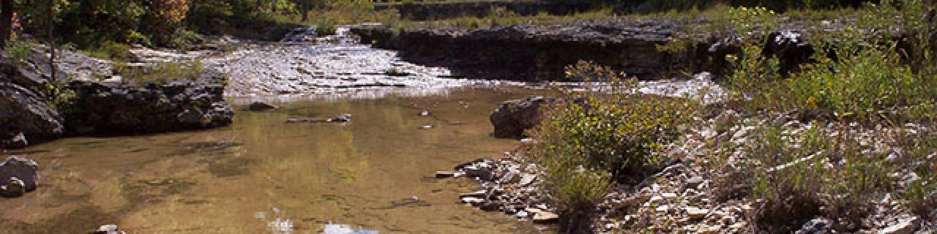
This area has karst topography, with many sinkholes, caves, sinks and seeps. Located within the wilderness are Fiddler and Bliss Springs, off the Whites Creek Trail. There are short spur trails that lead to each of them.
The area is generally rolling hills with steeper bluffs located near the Eleven Point Wild and Scenic River. Whites Creek flows through the wilderness and flows year-round and flows into the Eleven Point River.
Trails
The major way of travel within the Irish Wilderness is the 18.6 mile Whites Creek Trail.
Wilderness Environment
Visitors may see snakes, bear, deer and other typical Ozark wildlife. This area is known for having a high concentration of bear. Please ensure that when visiting you are being Bear Aware.
As you hike through these wilds, you may encounter typical Ozark wildlife: deer, squirrel, rabbit, raccoon, fox, bobcat, coyote, turkey, vulture, hawk, and owl. Watch your step lest you disturb a sleeping copperhead, rattlesnake, or eastern cottonmouth.
Within the wilderness you will see a variety of trees, including oak, hickory, shortleaf pine, dogwood, persimmon, and sassafras.
Maps and Brochures
- Trail System Map available on the Avenza app.
- Quadrangle maps for this wilderness are: Wilderness, Riverton, and small sections in Handy and Bardley. The Whites Creek Trail is entirely in the Wilderness and Riverton maps. They are available for sale at Forest Service Offices or on the USGS Website.
Active Alerts
General Information
The Ozark climate is mild enough to make Wilderness visits feasible throughout the year, as long as visitors bring proper gear. When possible, take advantage of this opportunity and plan your 'visit outside the peak spring and fall use seasons.
Private Property – there is a lot of private property around the wilderness. Please be aware of where you are traveling.
Safety Information
Wilderness has inherent dangers, and is a primitive setting where you meet nature on its own terms.
- Bring a map and compass, and first aid kit.
- During temperate months, be prepared for biting insects, poison ivy and high temperatures.
- Be advised of hunting seasons.
- Avoid using the trail during excessively wet periods.
- Be sure to tell someone your plans,
- Don’t hike the wilderness alone and
- Carry extra supplies so you are prepared to take care of yourself in case you get lost, injured, or delayed.
- The universal distress signal is three of anything: shots, shouts, smokes, whistles.
- Be prepared to sanitize water for drinking
For more safety tips visit the Safety section of the website.
Camping
Protect the solitude; seek out campsites in the Wilderness that are out of sight and sound of trails and other camps. When sharing an area keep a low profile and maintain the solitude.
Dispersed camping is the term used for free camping anywhere in the National Forest OUTSIDE of a designated campground.
Dispersed camping means there are no toilets, no structures, no trash cans, no treated water, and no fire grates.
There are extra responsibilities required for this type of camp. It's a must to educate yourself before you try it, but we hope the adventure of dispersed camping in the Mark Twain National Forest calls to you!
- Pick a Campsite and follow the Leave No Trace Principles
- Camp 100 feet away from trails and water sources.
- Treat any water found in the area before consuming it.
- Human waste (Feces) must be buried at least 6 inches deep and covered.
- Pack out all of your garbage.
January - December
Commercial use will not be permitted. Special uses will not be permitted, except for access to surrounded private property.
Wilderness
- Limit your party size to 10 persons;
- no camping within 100 feet of trails, water sources and other camps.
- Terrain is sometimes steep.
- No motorized or mechanized equipment allowed.
- Practice Leave No Trace outdoor ethics;
- Never tie stock directly to trees.
- Commercial use will not be permitted.
- Special uses will not be permitted, except for access to surrounded private property.
- Pack out all of your trash
Trailheads
- No trash containers; please pack out all your trash.
- Dogs on leash
- No fireworks
There are no fees at any trailheads or access points for the Wilderness.
Trail Use
Dogs are allowed on hiking trails, as long as they are kept on a leash. Unleashed dogs can pose a danger to your pet, the natural resources of the area, and other forest visitors.
- Leashes must be six feet, or shorter, when in developed recreation sites, including trails within the boundaries (36 CFR 261.16(j)) when they are not inside an enclosed vehicle or tent.
- Yield your leashed dog around other hikers and horses.
- Pack out your dogs waste or bury it 100 feet from water and trails.
Camping
- Keep dogs on a six-foot, or shorter, leash when they are not inside a tent.
- Store dog food in bear-resistant containers and feed your pet away from the campsite.
- Pick up and bag your dog’s waste. Place it in a provided trash receptacle or pack it out.
- Do not leave your dog unattended at any time.
- Do not leave your dog in the vehicle on a hot day.
- Keep your dog in your tent or vehicle at night.
- Ensure that there is ample water available for your pet.
Wildlife
- Do not allow them to interact with wildlife

Address: #66 Confederate Ridge Road Doniphan, MO 63935
Phone: 573-996-2153
Hours: 8:00 am - 4:30 pm, Monday to Friday; District Offices closed 1 - 1:30 for lunch (Closed on federal holidays)
Office Email: sm.fs.marktwainnf@usda.gov
Getting There
Directions
There are two trailheads to access the Wilderness and Whites Creek Trail. Brawley Pond Trailhead is on the northern end of the wilderness and Camp Five Pond Trailhead is on the northeastern portion of the wilderness.
The southern portion of the wilderness can be accessed via boat/canoe/kayak from Whites Creek Float Camp on the Eleven Point Wild and Scenic River. There is no parking or vehicle access at Whites Creek Float Camp.
Camp Five Trailhead
From Van Buren
- Take US 60 west for 10 miles
- Turn left to go south on Highway J
- Drive about 16 miles south and the trail head road is on the right.
Brawley Pond Trailhead
From Van Buren
- Take US 60 west for 10 miles
- Turn left to go south on Highway J and drive about 10 miles south and turn right on Highway K.
- Take Highway K for 2.8 miles
- Turn right onto County Road 158 for .3 miles
- Turn left onto County Road 160 for .2 miles.
- At the 90 degree turn right to stay on County Road 160 for 1/10 of a mile
- Turn left onto County Road 163 for .4 miles and the trailhead will be on the right
Parking
- Brawley Pond Trailhead: 4 vehicles
- Camp Five Pond Trailhead: 12 vehicles
Facility and Amenity Information
Restrooms
Restrooms are not available at this site.
Water
Potable water is not available at this site.
Drinking water is not available in Irish Wilderness, open water sources within the wilderness are not recommended for drinking. Bring your own drinking water or be prepared to boil or treat water chemically.
Nearby Trails
Recreation Opportunities
Horseback Riding Info
Trailheads
- Brawley Pond Trailhead
- Camp Five Pond Trailhead
Visiting the Wilderness is a primitive experience: trails are not well marked, and there are no bridges crossing streams.
Be aware of natural hazards that may occur within the Wilderness, and take precaution to maintain your safety.
We recommend you download a digital map or obtain a print map before heading into the wilderness.
Whites Creek Trail
The Whites Creek Trail is a 18.6 mile trail within the Irish Wilderness. Trails within the wilderness are not signed or marked, except at junctions.
The major trailhead into the Wilderness is Camp Five Pond located off Highway J.
There are three short spur trails from the main trail at Fiddler Spring, Whites Creek Float Camp, and Bliss Spring. There is also trail access at Brawley Pond Trailhead.
Horse Camping Info
Dispersed camping is allowed within the wilderness.
Backpacking Info
Trailheads
- Brawley Pond Trailhead
- Camp Five Pond Trailhead
Visiting the Wilderness is a primitive experience: trails are not well marked, and there are no bridges crossing streams.
Be aware of natural hazards that may occur within the Wilderness, and take precaution to maintain your safety.
We recommend you download a digital map or obtain a print map before heading into the wilderness.
Whites Creek Trail
The Whites Creek Trail is a 18.6 mile trail within the Irish Wilderness. Trails within the wilderness are not signed or marked, except at junctions.
The major trailhead into the Wilderness is Camp Five Pond located off Highway J.
There are three short spur trails from the main trail at Fiddler Spring, Whites Creek Float Camp, and Bliss Spring. There is also trail access at Brawley Pond Trailhead.
Day Hikes Info
Trailheads
- Brawley Pond Trailhead
- Camp Five Pond Trailhead
Visiting the Wilderness is a primitive experience: trails are not well marked, and there are no bridges crossing streams.
Be aware of natural hazards that may occur within the Wilderness, and take precaution to maintain your safety.
We recommend you download a digital map or obtain a print map before heading into the wilderness.
Whites Creek Trail
The Whites Creek Trail is a 18.6 mile trail within the Irish Wilderness. Trails within the wilderness are not signed or marked, except at junctions.
The major trailhead into the Wilderness is Camp Five Pond located off Highway J.
There are three short spur trails from the main trail at Fiddler Spring, Whites Creek Float Camp, and Bliss Spring. There is also trail access at Brawley Pond Trailhead.
Viewing Scenery Info
Eleven Point Wild and Scenic River
The Eleven Point National Wild and Scenic River meanders through the picturesque Ozark hills of southern Missouri. Its course is cut in the shadows of steep bluffs, through sloping forested valleys, and low-lying riparian ecosystems. Barely more than a small stream at its upper reaches near Thomasville, it gains considerable width and depth as its proceeds south-eastward.
Access to the Irish Wilderness from the Eleven Point Wild and Scenic River is from Whites Creek Float Camp, a short spur trail will connect you to the Whites Creek Trail, located within the wilderness.
Recreation Groups

The Eleven Point National Wild and Scenic River meanders through the picturesque Ozark hills of southern Missouri.

The 16,277-acre Irish Wilderness is a dense forest of oaks and hickory that was designated in 1984.