McGarr Ridge Trailhead
McGarr Ridge Trailhead is located on the south side of CC Highway about 4 miles east of Dora, MO. It provides access to the Devil's Backbone Wilderness Area.
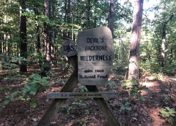
This wilderness takes its name from a long narrow ridge known to early settlers as Devil’s Backbone. There is a unique blend of Missouri Ozark’s flora and fauna, characterized by rugged topography, springs, and the North Fork River.
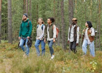
With 6,595 acres inside the Wilderness’ boundaries, this is an ideal area for day hiking or overnight backpacking.
General Information
Camping
North Fork Recreation Area locally known as Hammond Camp adjoins the north edge of the wilderness and provides quality camping and picnic opportunities. There is a designated canoe launch in this Recreation Area.
Dispersed camping is the term used for free camping anywhere in the National Forest OUTSIDE of a designated campground.
Dispersed camping means there are no toilets, no structures, no trash cans, no treated water, and no fire grates.
There are extra responsibilities required for this type of camp. It's a must to educate yourself before you try it, but we hope the adventure of dispersed camping in the Mark Twain National Forest calls to you!
- Pick a Campsite and follow the Leave No Trace Principles
- Camp 100 feet away from trails and water sources.
- Treat any water found in the area before consuming it.
- Human waste (Feces) must be buried at least 6 inches deep and covered.
- Pack out all of your garbage.
January - December
6 a.m. to 10 p.m.
Wilderness
- Limit your party size to 10 persons;
- no camping within 100 feet of trails, water sources and other camps.
- Terrain is sometimes steep.
- No motorized or mechanized equipment allowed.
- Practice Leave No Trace outdoor ethics;
- Never tie stock directly to trees.
- Commercial use will not be permitted.
- Special uses will not be permitted, except for access to surrounded private property.
- Pack out all of your trash
At the Trailhead
- No overnight camping in day use areas at any time of year.
- Dogs must be on a 6 foot leash in the day use area
- No trash containers in the parking lot; please pack out all your trash.
- Fireworks are prohibited.
Trail Use
Dogs are allowed on hiking trails, as long as they are kept on a leash. Unleashed dogs can pose a danger to your pet, the natural resources of the area, and other forest visitors.
- Leashes must be six feet, or shorter, when in developed recreation sites, including trails within the boundaries (36 CFR 261.16(j)) when they are not inside an enclosed vehicle or tent.
- Yield your leashed dog around other hikers and horses.
- Pack out your dogs waste or bury it 100 feet from water and trails.
Camping
- Keep dogs on a six-foot, or shorter, leash when they are not inside a tent.
- Store dog food in bear-resistant containers and feed your pet away from the campsite.
- Pick up and bag your dog’s waste. Place it in a provided trash receptacle or pack it out.
- Do not leave your dog unattended at any time.
- Do not leave your dog in the vehicle on a hot day.
- Keep your dog in your tent or vehicle at night.
- Ensure that there is ample water available for your pet.
Wildlife
- Do not allow them to interact with wildlife
None

Address: 1006 S. Jefferson Ava, MO 65608
Phone: 417-683-4428
Hours: 8:00 am - 4:30 pm, Monday to Friday; District Offices closed 1 - 1:30 for lunch (Closed on federal holidays)
Office Email: sm.fs.marktwainnf@usda.gov
Getting There
Latitude / Longitude
Latitude: 36.761328
Longitude: -92.13144
Directions
McGarr Ridge Trailhead is located on the south side of CC Highway about 4 miles east of Dora, MO
Facility and Amenity Information
Restrooms
Restrooms are not available at this site.
Water
Potable water is not available at this site.
Nearby Trails
Recreation Opportunities
Day Hikes Info
When traveling on a trail, stay on the trail. When traveling cross-country use your map and compass. Use of blazes, ribbons or other trail markers should be avoided; let the next fellow find his own way as you did.
Remember saddle and pack stock have the right-of-way on trails. Give way to them and avoid conflicts and possible accidents.
Backpackers should leave no sign of their presence so that the next person can enjoy natural scenes and solitude. You must tread lightly so nature can endure and replenish.
- Trail Length: 13 miles
- Trail Surface Type: Unsurfaced, native material.
Terrain: Terrain is sometimes steep. Elevations range from 680 to 1,020 feet.
Best Seasons: Fall, winter, and spring.
Backpacking Info
When traveling on a trail, stay on the trail. When traveling cross-country use your map and compass. Use of blazes, ribbons or other trail markers should be avoided; let the next fellow find his own way as you did.
Remember saddle and pack stock have the right-of-way on trails. Give way to them and avoid conflicts and possible accidents.
Backpackers should leave no sign of their presence so that the next person can enjoy natural scenes and solitude. You must tread lightly so nature can endure and replenish.
- Trail Length: 13 miles
- Trail Surface Type: Unsurfaced, native material.
Terrain: Terrain is sometimes steep. Elevations range from 680 to 1,020 feet.
Best Seasons: Fall, winter, and spring.
Horseback Riding Info
When traveling on a trail, stay on the trail. When traveling cross-country use your map and compass. Use of blazes, ribbons or other trail markers should be avoided; let the next fellow find his own way as you did.
Remember saddle and pack stock have the right-of-way on trails. Give way to them and avoid conflicts and possible accidents.
Backpackers should leave no sign of their presence so that the next person can enjoy natural scenes and solitude. You must tread lightly so nature can endure and replenish.
- Trail Length: 13 miles
- Trail Surface Type: Unsurfaced, native material.
Terrain: Terrain is sometimes steep. Elevations range from 680 to 1,020 feet.
Best Seasons: Fall, winter, and spring.
Recreation Groups
With 6,687 acres inside the Wilderness boundary, this is an ideal area for day hiking or overnight backpacking.