Paddy Creek Recreation Area
The Paddy Creek Recreation Area is nestled in a hollow along Paddy Creek, a major tributary to the Big Piney River, 1/2 mile away.
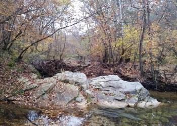
Fort Leonard Wood is just north of the recreation area, occasionally you may hear the guns fired at the military training base. Otherwise, the area is very beautiful and tranquil along the creek.
The recreation area is located adjacent to the east boundary of the Paddy Creek Wilderness and serves as one of the 3 trailheads for the Big Piney Trail. This site also has a day use area and camping. Visitors during the summer will find the area a bit more bustling, but spring and fall are just as beautiful times to visit, albeit quieter.
Paddy Creek flows year-round and is a crystal clear wading creek.
General Information
Sites are mostly secluded with an open meadow space at the beginning of the campground for outdoor activities. There is river and bluff side camping.
Amenities include: picnic tables, lantern posts, fire rings, garbage removal provided.
No. of Sites
Single: 18, no electric Double: 1, no electric
RV Camping
Sites are mostly secluded with an open meadow space at the beginning of the campground for outdoor activities. There is river and bluff side camping.
Amenities include: picnic tables, lantern posts, fire rings, garbage removal provided.
There are no RV hookups at this location.
No. of Sites
- Single: 18, no electric
- Double: 1, no electric
Size Restrictions
Can accommodated up to 34' RVs.
Vehicle Clearance
No restrictions
Pavement Type of Parking
Asphalt
April 1 - December 1
Quiet Hours: 10 pm to 6 am
Camping Discount
- There is a 50% discount for camping for anyone with an Interagency Access or Senior Pass.
- The discount applies only to the fee for the campsite physically occupied by the pass holder, not to any additional fee or campsite(s) occupied by members of the pass holder's party.
When you are visiting, please remember:
- Campground: Fees will be paid at the fee tube provided.
- Fireworks are prohibited.
- Campsite parking allows for two vehicles per site. Park only in designated parking areas.
- No more than 8 people are permitted at single sites (16 for double sites).
- Dogs must be on a 6 foot leash in the campground.
- Only collect dead and downed wood for campfires.
Overnight Use:
Single Site: $15 per night
Dogs are allowed at campsites and developed recreation areas; however, they should not be allowed to run loose in recreation areas where they will disturb other forest visitors. Be mindful of the impact a barking dog can have on other forest visitors.
- Keep dogs on a six-foot, or shorter, leash when they are not inside an enclosed vehicle or tent.
- Store dog food in bear-resistant containers and feed your pet away from the campsite.
- Pick up and bag your dog’s waste. Place it in a provided trash receptacle or pack it out.
- Do not leave your dog unattended at any time.
- Do not leave your dog in the vehicle on a hot day.
- Keep your dog in your tent or vehicle at night.
- Ensure that there is ample water available for your pet.

Address: 108 S. Sam Houston Blvd. Houston, MO 65483
Phone: 417-967-4194
Hours: 8:00 am - 4:30 pm, Monday to Friday; District Offices closed 1 - 1:30 for lunch (Closed on federal holidays)
Office Email: sm.fs.marktwainnf@usda.gov
Getting There
Latitude / Longitude
Latitude: 37.553462
Longitude: -92.04029
Directions
From Roby, MO
- take Highway 17 north 2 miles,
- turn right/east on Slabtown Road (formerly Forest Road 7600) and travel 6 miles to Paddy Creek Road
- turn right/south on Paddy Creek Road (formerly Forest Road 220) and travel for 2 miles
- the recreation area is on the left, just over the low water crossing/bridge*
*Water flows over this crossing at all times, however it can be unpassable after a heavy rain. Please drive carefully at all times over this crossing.
From Licking, MO
- take Highway 32 west for 15 miles to Paddy Creek Road
- turn right/north onto Paddy Creek Road and travel for 8 miles
- the rec area will be on the right just before the creek.
From Ft. Leonard Wood:
- Take South Gate onto Hwy AW for 6.7 miles to Hwy 17
- turn left/east for 1 mile then left onto Slabtown Rd.
- continue on Slabtown Rd for 4.3 miles,
- then take a right onto Paddy Creek Rd.
- continue for 2 miles; Paddy Creek Recreation Area is on the left.
Parking
Day Use: 15 vehicles
Facility and Amenity Information
Accessibility
Toilets are accessible
Restrooms
Restrooms are available at this site.
Water
Potable water is not available at this site.
Nearby Trails
Recreation Opportunities
Backpacking Info
A trailhead in the day use area provides access to the Paddy Creek Trail system and the Paddy Creek Wilderness trails.
Paddy Creek Trail is a 1-mile hiking trail beginning and ending at the Paddy Creek Recreation Area.
There are 18 miles of designated trails within the Paddy Creek Wilderness. The elevation of the area changes 500 feet between a point near Roby Tower on the western edge of the area, and Paddy Creek as it meets the eastern boundary of the Wilderness. Signs and trail marking are minimal or non-existent and the use of maps and compass is recommended.
Picnicking - Single Info
The picnic area is located immediately off the county road near the entrance to the recreation area. Picnic tables are located between the road and Paddy Creek. Visitors will have excellent views of the creek and enjoy a shaded, cool meal in the heat of the summer.
No. of Sites
Individual Sites: 4
Swimming Info
Access to Paddy Creek is spread along the recreation area with many locations for visitors to hop into the creek. The cool, clear waters are excellent for those seeking to cool off on a hot summers day. Even in the dry season visitors can find deep pools along Paddy Creek.
The area is not managed for swimming: there are no lifeguards, depth or hazard markers, and the water is not tested.
Hunting Info
This site is open for hunting season. Hunters come to hunt throughout the area during deer and turkey seasons. Please do not shoot your gun within 100 yards of the recreation area.