Fire regimes of California montane and subalpine grasslands
Citation:
U.S. Department of Agriculture, Forest Service, Missoula Fire Sciences Laboratory. 2019. Fire regimes of California montane and subalpine grasslands: Information from Information from the Pacific Southwest Research Station and LANDFIRE.
In: Fire Effects Information System, [Online].
U.S. Department of Agriculture, Forest Service,
Rocky Mountain Research Station, Missoula Fire Sciences Laboratory (Producer).
Available: https://www.fs.usda.gov/database/feis/fire_regimes/CA_montane_subalpine_grass/all.html
[].
Information from:
PACIFIC SOUTHWEST RESEARCH STATION
The Pacific Southwest Research Station, Forest Service, U.S. Department of Agriculture, provides a review and synthesis of the historical range of variability in California montane and subalpine grasslands in the Sierra Nevada and the southern Cascades (Gross 2016
[2]). It includes information on:
- Physical setting and geographic distribution
- Ecological setting
- Holocene history
- Cultural-socioeconomic setting
- Reference conditions
- Descriptions of natural range of variation including:
- plant community composition (geographic distribution of major hardwood species, successional changes, diversity)
- stand structure (age class; cover, density, and basal area; patch sizes; distribution of fuel loads)
- function (climate; disturbances including fire, grazing, hydrology and flooding, and invasive species; soils and nutrient cycling)
- Deviations from natural variation and future trends
The literature review of fire regimes occurs in the in the "Key indicators of natural range of variation" section of this publication. The Fire Regime Reports on California low-elevation grasslands and Great Basin desert grasslands cover grassland communities of California not covered here.
 |
| Figure 1—A subalpine meadow near Sonora Pass on the Stanislaus National Forest. Lodgepole pine encroachment is discussed in the Pacific Southwest Research Station paper. USDA, Forest Service image by Janet Fryer. |
LANDFIRE MODELING
LANDFIRE modeled succession and fire frequency of Biophysical Settings (BpSs). Table 1 summarizes LANDFIRE data on the BpSs for California montane and subalpine grasslands. Figure 1 shows where they occur.
Table A1 lists the BpSs and the results of LANDFIRE succession modeling for each BpS. The BpSs included in this Fire Regime Report cover all of California, while information in the synthesis of the historical range of variability (Gross 2016 [2]) only includes grasslands in the Sierra Nevada and southern Cascades.
| Table 1—Modeled fire intervals and severities for California montane and subalpine grasslands [3]. |
| Fire intervala |
Fire severityb (% of fires)
|
Number of Biophysical Settings (BpSs) in each fire regime group
|
| |
Replacement |
Mixed |
Low |
I |
II |
III |
IV |
V |
NAc |
| 16-65 years |
80-100 |
0-20 |
0 |
0 |
5 |
0 |
2 |
0 |
0 |
aMean historical
fire interval
derived from LANDFIRE succession modeling (labeled "MFRI" in LANDFIRE).
bPercentage of fires in 3 fire severity classes, derived from LANDFIRE succession modeling. Replacement-severity fires cause >75% kill or top-kill of the upper canopy layer; mixed-severity fires cause 26%-75%; low-severity fires
cause <26% [1,3].
cNA (not applicable) refers to BpS models that did not include fire in simulations. |
 |
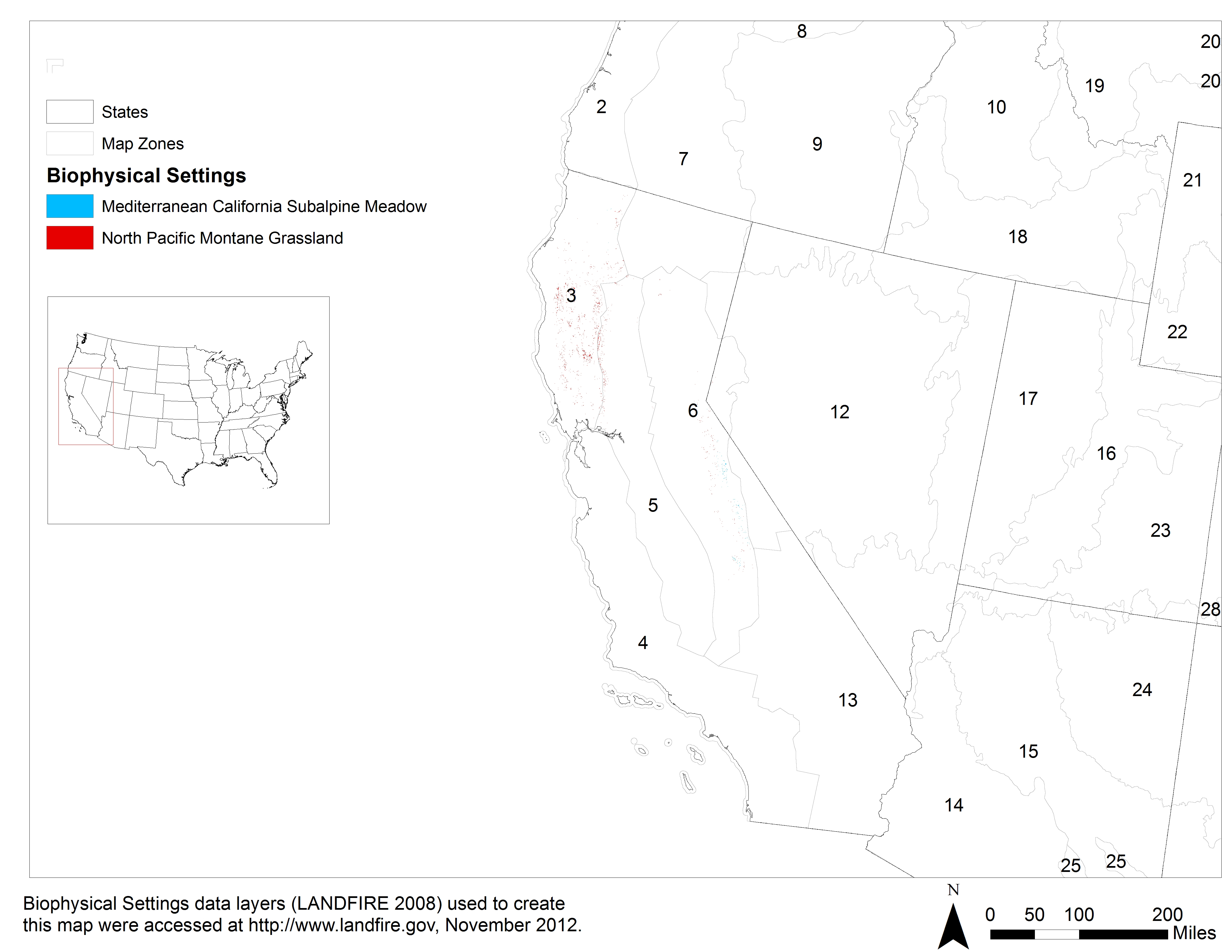
| Figure 2—Distribution of California montane and subalpine grasslands based on the LANDFIRE Biophysical Settings (BpS) data layer
[4]. Numbers indicate LANDFIRE
map zones. LANDFIRE did not map every BpS in this group. |
| Table 2—Plant community composition and species diversity are highly variable in these grassland communities. Dominant plant species discussed in the Pacific Southwest Research Station's [2] review and LANDFIRE's [3] BpS descriptions are listed below. Links go to FEIS Species Reviews. |
| Common name |
Scientific name |
| Forbs |
| common yarrow |
Achillea millefolium |
| broadleaf lupine |
Lupinus latifolius |
| tundra aster |
Oreostemma alpigenum |
| Graminoids |
| California brome |
Bromus carinatus |
| Idaho fescue |
Festuca idahoensis |
| Merten's rush |
Juncus mertensianus |
| mountain rush |
Juncus arcticus var. littoralis |
| nodding needlegrass |
Nassella cernua |
| panicled bulrush |
Scirpus microcarpus |
| Pennsylvania sedge |
Carex pensylvanica |
| Nebraska sedge |
Carex nebrascensis |
| shorthair reedgrass |
Calamagrostis breweri |
| shorthair sedge |
Carex exserta |
| squirreltail |
Elymus elymoides |
| Shrubs |
| Bloomer goldenbush |
Ericameria bloomeri |
| Trees |
| Sierra lodgepole pine |
Pinus contorta var. murrayana |
References:
1. Barrett, S.; Havlina, D.; Jones, J.; Hann, W.; Frame, C.; Hamilton, D.; Schon, K.; Demeo, T.; Hutter, L.; Menakis, J. 2010. Interagency fire regime condition class guidebook (FRCC), [Online], (Version 3.0). In: Interagency fire regime condition class website. U.S. Department of Agriculture, Forest Service; U.S. Department of the Interior; The Nature Conservancy (Producers). Available: https://www.frames.gov/documents/frcc/documents/FRCC+Guidebook_2008.10.30.pdf [2019, March 20]. [85876]
2. Gross, Shana. 2016. Natural range of variability for meadows in the Sierra Nevada and south Cascades, [Online]. In: Pacific Region, Ecology program documents, reports and publications, Natural range of variation of Sierra Nevada habitats. Vallejo, CA: U.S. Department of Agriculture, Forest Service, Pacific Southwest Region (Producer). Available: https://www.fs.usda.gov/detail/r5/plants-animals/?cid=stelprdb5434436 [2016, November 4]. 44 p. [+ supplementary information]. [91155]
3. LANDFIRE Rapid Assessment. 2005. Reference condition modeling manual (Version 2.1). Cooperative Agreement 04-CA-11132543-189. Boulder, CO: The Nature Conservancy; U.S. Department of Agriculture, Forest Service; U.S. Department of the Interior. 72 p. On file at: U.S. Department of Agriculture, Forest Service, Rocky Mountain Research Station, Fire Sciences Laboratory, Missoula, MT. [66741]
4. LANDFIRE. 2008. CONUS refresh (LANDFIRE 1.1.0). Biophysical settings layer. In: LANDFIRE data distribution site, [Online]. In: LANDFIRE. U.S. Department of the Interior, Geological Survey (Producer). Available: https://landfire.cr.usgs.gov/viewer/ [2015, October 7]. [89416]
FEIS Home Page