| FEIS Home Page |
 |
| Figure 1—Fire in a Wyoming big sagebrush community. Photo by Scott Schaff. |
This synthesis summarizes information available in the scientific literature on presettlement patterns and postsettlement changes in fuels and fire regimes in Wyoming big sagebrush and basin big sagebrush communities. This literature suggests that presettlement fires in the sagebrush biome were both human- and lightning-caused. Peak fire season occurred from April to October and varied geographically. Wildfires were typically stand replacing. Fire frequency was influenced by site characteristics, and frequency estimates ranged from decades to centuries, depending on applicable scales, methods used, and metrics calculated. Because big sagebrush communities occur over a productivity gradient driven by soil temperature and moisture regimes, presettlement fire frequencies likely varied across the gradient, with more frequent fire on more productive sites that supported more continuous fine fuels. Because sites dominated by Wyoming big sagebrush were drier and tended to produce fewer fine fuels, they tended to burn less frequently than sites dominated by mountain big sagebrush, while basin big sagebrush sites tended to be intermediate. Big sagebrush communities adjacent to fire-prone woodland and forest types (e.g., ponderosa pine) may have had more frequent fires than those adjacent to less fire-prone types (e.g., pinyon-juniper woodlands) and those far from forests and woodlands. Most fires were likely small (less than ~1,200 acres (~500 ha)), and large fires (>24,000 acres (10,000 ha)) were infrequent. Large fires were most likely after 1 or more cool, wet years that allowed fine fuels to accumulate and become continuous.
Since European-American settlement, fuel and fire regime characteristics in many big sagebrush communities have shifted outside the range of historical variation. Settlement generally began in the late 1800s and caused changes in ignition patterns and fuel characteristics, although the timing and magnitude of these changes varied among locations. Since then, fuels and fire regimes in many sagebrush ecosystems have changed due to a combination of interrelated factors, including fire exclusion; proliferation of nonnative invasive plants; woodland expansion; overgrazing by livestock; climate changes; land alteration for agriculture and rangeland; and energy, urbanization, and infrastructure development. Since 1980, the number of fires each year and total annual area burned have increased in the sagebrush biome. Limited data suggest that fires have become more frequent in most Wyoming big sagebrush and basin big sagebrush communities, with the exception of communities in the Wyoming Basin ecoregion, where fires may have become less frequent. More frequent fire has been attributed primarily to increased cheatgrass cover and increased human ignitions.Six subspecies of big sagebrush grow in the western United States: three major subspecies with wide distributions—Wyoming big sagebrush, basin big sagebrush, and mountain big sagebrush—and three subspecies with limited distributions—Mojave big sagebrush, xeric big sagebrush, and snowfield big sagebrush [42,43,112,141,161,181,182]. Researchers identify three primary ecosystems dominated by big sagebrush: Intermountain Basins big sagebrush steppe, Intermountain Basins big sagebrush shrubland, and Intermountain Basins montane sagebrush steppe [20,281,291,335]. Wyoming big sagebrush or basin big sagebrush tend to dominate the first two, while mountain big sagebrush tends to dominate the last. The focus of this synthesis is ecosystems or communities historically dominated by Wyoming big sagebrush or basin big sagebrush. In this synthesis, "big sagebrush" refers to all six big sagebrush subspecies. In many cases, particularly regarding presettlement fire regimes in Wyoming big sagebrush and basin big sagebrush communities, clear distinctions among sagebrush taxa were lacking in the literature. Although Wyoming big sagebrush and basin big sagebrush biology and ecology differ from each other, from that of the other big sagebrush subspecies, and from other sagebrush taxa [259,391], Kitchen and McArthur [191] suggested that inferences made about the fire ecology of the subgenus Tridentatae as a whole will largely hold true for all big sagebrush subspecies. Reviews of fire regimes in big sagebrush ecosystems that are cited throughout this synthesis include: [14,121,151,191,198,261,263,267,272,290,324,366].
The following FEIS publications cover fire regimes of sagebrush communities other than Wyoming big sagebrush and basin big sagebrush: For information regarding the biology and ecology of Wyoming big sagebrush and basin big sagebrush, how fire affects them, and how Wyoming big sagebrush and basin big sagebrush communities respond to fire, see the FEIS Species Reviews about Wyoming big sagebrush and basin big sagebrush. In this synthesis, the "presettlement" or "historical" period refers to the period during the Little Ice Age, about 1300 to 1850, after which substantial European-American settlement and development began in many locations in the sagebrush biome [263]. The Little Ice Age was the wettest and coolest period during the late Holocene [263], but substantial changes in the ecological relationships of plants in the sagebrush biome did not occur with changes in climate during the Little Ice Age [153]. Hann et al. [153] concluded that prior to European-American settlement, broad-scale biophysical relationships in the Great Basin had been relatively stable for about 2,000 years, with sagebrush, graminoids, junipers, and pinyons dominating much of the landscape. However, the relative abundance and distribution of sagebrush, graminoids, junipers, and pinyons have fluctuated over the past 2,000 years due to variability in climate and fire patterns [248,263,283,408]. Since the end of the Little Ice Age, the global climate has been warming, with important implications for sagebrush ecosystems (see Climate Change). Kitchen and McArthur [191] cautioned that "judgments made when comparing presettlement big sagebrush conditions corresponding to the end of the Little Ice Age with contemporary environmental conditions should be tempered by the context of the corresponding change in climate". |
| Figure 2—Presettlement distribution of Wyoming big sagebrush and basin big sagebrush steppes (in blue) and shrublands (in shades of red) based on the LANDFIRE Biophysical Settings data layer [230]. Click on the map for a larger image. |
DISTRIBUTION
Wyoming big sagebrush and basin big sagebrush steppe and shrubland communities are widely distributed throughout the West, and occur mostly in the Intermountain West (the region bounded by the Cascade Range, Sierra Nevada, and Arizona/New Mexico mountains to the west and the front ranges of the Rocky Mountains to the east), but they extend east into the Northwestern Great Plains. The distribution of big sagebrush steppe mostly occurs north of approximately 41 °N latitude and roughly overlaps the distribution of LANDFIRE's Biophysical Settings series 11250, 10800, and 10801. The distribution of big sagebrush shrubland mostly occurs south of approximately 41 °N latitude and roughly overlaps with the distribution of series 10802. Their distributions are illustrated by Miller and Eddleman (fig. 1, pg. 4) [261]. Figure 2 shows the distribution of big sagebrush steppe and shrubland Biophysical Settings as mapped by LANDFIRE [230]. Provencher et al. [310] recommended that managers compare LANDFIRE products with maps derived from local data on historical vegetation patterns to ensure that the accuracy of the products is sufficient for their application. For example, these researchers noted only "moderately successful" agreement between LANDFIRE Biophysical Settings data layers and maps derived from local data from the Wassuck Range, Nevada.
While the presettlement distribution and relative abundance of sagebrush are debated (see Sagebrush Distribution), it is certain that the land area historically occupied by sagebrush communities has been reduced and altered by the cumulative and interacting effects of altered fire regimes, livestock grazing and associated land management, proliferation of nonnative invasive plants, woodland expansion, climate changes, agriculture, urban and industrial land uses, and other factors [50,60,101,153,197,263,266,271,276,391]. Miller et al. [263] estimated that only 55% of the area delineated on Kuchler's [204] maps as potentially dominated by sagebrush was occupied by sagebrush in 2011. In an assessment of an area encompassing the Interior Columbia Basin and portions of the Klamath Basin and Great Basin, Hann et al. [153] estimated that dry shrub communities—which included big sagebrush (Wyoming big sagebrush and basin big sagebrush), low sagebrush, threetip sagebrush, antelope bitterbrush, and salt desert shrub communities—occupied ~30% of the area from 1850 to 1900 and ~21% of the area from 1900 to 1997. This is a reduction of ~30% [139]. According to West [401], no refugia exist to use as reference conditions because nearly all sagebrush communities have been grazed by livestock, invaded by nonnative plants, and/or have altered fire regimes (see Postsettlement Changes in Fuels and Fire Regimes).
Sagebrush Distribution
Disagreement about the presettlement distribution and relative abundance of big sagebrush communities occurs throughout the published literature [149,191,249,390]. One view maintains that grassland steppes were not abundant in presettlement landscapes and that the contemporary distribution of big sagebrush steppes is similar to the presettlement distribution, with the exception of lands converted to other uses. While this view acknowledges changes in big sagebrush dominance in response to livestock grazing, altered fire regimes, and other disturbances, it disputes the idea that contemporary big sagebrush stands are the result of widespread succession of grasslands to shrublands due to fire exclusion [191,249]. Advocates of this viewpoint (e.g., [72,164,178,253,365,370,391]) generally consider big sagebrush densities within the historical range of variation [72,253] and attribute perceived increases in sagebrush distribution since European-American settlement to recovery from past disturbances [87,114,364,408], such as "promiscuous" burning by early European-American settlers [114]
(see Ignitions by European-American Settlers).
Another view maintains that grassland steppes were abundant during presettlement times and that livestock overgrazing and suppression of wildfires have resulted in less fire on the landscape and greater densities of big sagebrush, not only in big sagebrush steppes, but also in grassland steppes. Advocates of this viewpoint (e.g., [9,94,107,167,353]), generally consider big sagebrush an indicator of grassland degradation [191,249].
The disagreement about the presettlement distribution and relative abundance of big sagebrush communities is likely to continue because reliable historical information is lacking or inconsistent and because neither viewpoint likely applies across the entire range of big sagebrush [191,249]. Historical accounts and repeat photographs have been interpreted to support both viewpoints [191,391]. Inconsistencies among historical accounts may be attributed to high variability among vegetation descriptions, which did not differentiate among big sagebrush subspecies and grouped together ecological types that varied in soil temperature and moisture regimes and time since last disturbance [149,242]. Comparison of photographs from two sites in 1886 and again in 1981 in the Southeastern Plains region of Montana indicate contrasting histories. One photograph shows similar cover of Wyoming big sagebrush 95 years later and establishment of Rocky Mountain juniper in draws, while the other shows a reduction in Wyoming big sagebrush cover and an increase in herbaceous plant cover 95 years later [146]. Repeat photographs from southwestern Montana (1870s–1980s) [9] and central Utah (1870s–2000s) [183] provide evidence and arguments in support of mountain big sagebrush spread into grasslands, whereas repeat photographs from 20 big sagebrush sites in Wyoming, northern Utah, and southeastern Idaho—taken in the 1870s, and again >100 years later (1974–1985)—suggest that grasslands and shrublands in the region have changed little in spite of a wide range of disturbances [178]. Reconstructions derived from General Land Office survey records suggest that 84% of four study areas in sagebrush communities in Idaho, Nevada, Oregon, and Wyoming were historically dominated by large, contiguous areas of "normal or dense" sagebrush cover [72].
Conifer Distribution
Historically, the distribution of pinyon-juniper ecosystems was dynamic, expanding and contracting throughout the Holocene, largely due to variability in climate and fire patterns [121,257,269,327,366,418]. These communities probably expanded into adjacent big sagebrush communities during periods of warm, moist climate and/or infrequent fire [327]. During the Little Ice Age and prior to European-American settlement, the vegetation of the Great Basin was thought to have been a mosaic of pinyon-juniper, juniper, and/or pinyon woodlands and savannas within a matrix of sagebrush steppes and shrublands. Woodlands were relatively open and often confined to fire-protected sites such as rocky ridges [191,267,269,358].
Since the late 1800s and early 1900s, density of junipers and pinyons has increased in many sagebrush and woodland communities [257,260,268,327], while it has not changed or has declined in others [327]. A study that compared LANDFIRE Biophysical Settings and Existing Vegetation Type data for five subregions found that the area covered by pinyon-juniper, juniper, and/or pinyon communities has increased the most in the Great Basin and Semi Desert subregion of Nevada and western Utah, followed by the Plateaus subregion of southeastern Utah and the Uinta and Wasatch Front subregions of northern Utah, northeastern Nevada, and southern Idaho. The area covered has increased very little or not at all in the Southern Greater Yellowstone subregion of western Wyoming and southeastern Idaho, and not at all in the Middle Rockies subregion of central Idaho [289]. Most conifer expansion has occurred on cool to warm, relatively moist sites—particularly in mountain big sagebrush, basin big sagebrush, and low sagebrush communities on moderately deep soils—but also in Wyoming big sagebrush and black sagebrush communities [93,121,153,176,260]. The combined effects of climate variability and fire frequency continue to be driving forces of conifer density on contemporary landscapes, along with other interacting factors including livestock grazing and carbon dioxide fertilization. The relative importance of each factor likely varies among locations [121,327] (see Woodland Expansion).
SITE CHARACTERISTICS
Big sagebrush communities occur along a gradient of soil temperature and moisture regimes, which are driven by a combination of soil characteristics, climate, elevation, and topography. Compared to other big sagebrush communities, Wyoming big sagebrush communities occur at low elevations on the warmest, driest sites and mountain big sagebrush communities occur at high elevations on the wettest, coolest sites. Wyoming big sagebrush communities tend to have the lowest annual production, while mountain big sagebrush communities tend to have the highest annual production. Basin big sagebrush communities tend to be intermediate in elevation, average annual precipitation, and annual production [119,140,198,261,275,391,412] (table 1).
| Table 1. Ranges of precipitation, elevation, soil depth, and aboveground annual plant production for three sagebrush types [261], (derived from [112,292,344]). | ||||
| Subspecies | Average annual precipitation (mm) |
Elevation (m) |
Soil depth | Annual production (kg/ha) |
| Wyoming big sagebrush | 180-300 | 150-1,200 | moderate | 440-775 |
| basin big sagebrush | 200-400 | <2,300 | deep | 868-2,352 |
| mountain big sagebrush | 350-450 | 1,200-3,200 | moderate-deep | 700-2,750 |
While considerable overlap in average annual precipitation and elevation occurs between Wyoming big sagebrush and basin big sagebrush sites [261] (table 1), Wyoming big sagebrush generally occurs on dry uplands with moderately deep soils of moderate fertility, while basin big sagebrush generally occurs in comparatively moist sites with deep, highly fertile soils, such as on alluvial fans, in canyon bottoms and dry washes, or along roadside ditches, drainages, and fence lines where soil aggregates and rain or snow accumulates and increases soil moisture availability [21,22,119,152,174,200,243,364,391,429]. Because they are often intermixed in small patches on a landscape [210,343], Wyoming big sagebrush and basin big sagebrush communities are often combined in broad-scale studies (e.g., [355,356,360]). Both subspecies may occur with mountain big sagebrush at cooler, moister sites at higher elevations [138,243], and hybrids occur in zones of overlap (e.g., [132,133,243,244,255,382,395]).
Climate
Big sagebrush is most common where winter precipitation exceeds summer precipitation (Dahl et al. 1976, cited in [373]). Summer precipitation in sagebrush ecosystems varies from almost none in central Nevada to nearly 40% of the annual total in southern Utah, northern Arizona, and northern New Mexico [112,397]. The distribution of big sagebrush in the Northwestern Great Plains is limited by the relative lack of winter precipitation and relatively greater summer precipitation that favors grass growth [179,200]. Summer storms can be brief and intense in most of big sagebrush's distribution, and most precipitation runs off or evaporates [201,290]. Snow accumulation and spring snowmelt are important in sagebrush ecosystems for recharging moisture deep in the soil profile [331,335]. Most big sagebrush shrublands occur where summer precipitation is greater, winter precipitation is less, and temperatures are warmer than where most big sagebrush steppes occur [261,399].
In the Intermountain West, climate is semiarid (9.8-19.7 inches (250-500 mm) mean annual precipitation) north of approximately 41 °N latitude, and becomes increasingly arid (<9.8 inches mean annual precipitation) farther south, except where mountains receive substantial precipitation. Seasonality of precipitation varies along geographical gradients, with the importance of winter and spring Pacific frontal storms decreasing and summer convectional storms increasing from north to south and west to east [190,195,398]. Precipitation is highly variable from year to year, and variability increases from north to south [261,307,401]. Mean temperature extremes range substantially, from a January low of -40 °F (-40 °C) to a July high of 113 °F (45 °C) [195].
In the Northwestern Great Plains, climate influences the transition from Wyoming big sagebrush steppe to Great Plains grasslands, with Wyoming big sagebrush cover decreasing as the proportion of summer precipitation increases. At 14 sites in Wyoming, Wyoming big sagebrush cover was positively correlated with the amount of winter precipitation (October–February), negatively correlated with the amount of summer precipitation (April–July), and negatively correlated with the distance from the Continental Divide in the Rocky Mountains, with shrub cover increasing west of the divide and decreasing east of the divide (r² = 0.76, P = 0.003). Approximately 20% of annual precipitation fell in winter west of the divide, and 25% fell in summer [102].
PLANT COMMUNITIES
Sagebrush and other shrubs, perennial graminoids, forbs, and often a
biological soil crust
characterize Wyoming big sagebrush and basin big sagebrush steppe and shrubland communities. Historically, these communities were treeless or had sparse trees [281]. Steppes are distinguished from shrublands by greater herbaceous cover [208,281,303]. Grasses associated with basin big sagebrush are similar to those associated with Wyoming big sagebrush. Perennial forbs are more abundant in basin big sagebrush stands than Wyoming big sagebrush stands [412]. Both communities can support high cover of biological soil crusts [44], which may be similar in composition in both communities (Kaltencker, unpublished data cited in [180]). NatureServe [281] provides the following information on steppes and shrublands dominated by Wyoming big sagebrush and/or basin big sagebrush in the western United States. Corresponding Biophysical Settings series are given in parentheses.
West [397,399] and Kuchler [203] also split the sagebrush biome into two types: big sagebrush steppe (termed western Intermountain sagebrush steppe by West [399] and sagebrush steppe by Kuchler [203]) and the warmer and more arid big sagebrush shrubland (termed Great Basin-Colorado Plateau sagebrush semi-desert by West [397] and Great Basin sagebrush by Kuchler [203]). While the two types occur along a productivity gradient of precipitation and soil development, big sagebrush steppe historically had more cover of perennial grasses, with "more or less equal sharing of dominance by sagebrush and bunchgrasses", while big sagebrush shrubland was historically dominated by sagebrush with relatively less cover of bunchgrasses [397,399] (see Kinds of fuels).
Table A2 lists the LANDFIRE Biophysical Settings covered in this synthesis, provides links to their descriptions, and summarizes data generated by LANDFIRE models [206].PRESETTLEMENT FUELS
Kinds of Fuels
Prior to European-American settlement, big sagebrush steppe was thought to be codominated by widely spaced sagebrush and perennial grasses, while big sagebrush shrubland was thought to be dominated by sagebrush with relatively less cover of perennial grasses [397,399]. The proportion of sagebrush and perennial grasses likely varied from grassland steppes with scattered sagebrush to sagebrush shrublands with sparse perennial grasses, depending on successional stage, site characteristics (e.g., topography and soils), grazing history, climate, and weather (e.g., [167,252,261,281,365,366,370,397,399,405]).
Herbaceous fuels are most abundant in early succession. Sagebrush canopy fuels increase with time since fire [45,144,168,386] (see Postfire recovery). The time required for Wyoming big sagebrush and basin big sagebrush communities to advance to late succession varies substantially among sites. Modeled Wyoming big sagebrush sites in southeastern Oregon reached the late-successional, closed-canopy stage in about 78 years in the absence of disturbances. When disturbances from insects, pronghorn, drought, and fire were included in the model, it took 83 years to reach that stage. Modeled basin big sagebrush sites reached the late-successional, closed-canopy stage in about 25 years in the absence of disturbances and 24 years when disturbances from insects, drought, and fire were included in the model. These estimates of basin big sagebrush were faster than those for mountain big sagebrush sites (31 years in the absence of disturbance and 33 years when disturbances from insects, voles, freeze-kill, snow mold, drought, and fire were included in the model) [125].
Density of big sagebrush fuels on the landscape was spatially and temporally variable. According to Winward [411], historical fires in Wyoming big sagebrush, basin big sagebrush, and mountain big sagebrush were patchy, leaving islands and stringers unburned in fire perimeters. This resulted in "an ever-changing mosaic of different densities and ages of sagebrush crowns" and a landscape that included stands ranging from open grasslands with few sagebrush plants to relatively dense stands of mature sagebrush [411]. Vincent [373] stated that in northern New Mexico, fire and insect defoliation probably maintained many Wyoming big sagebrush communities as open, seral stands with productive herbaceous understories.
Amount and Continuity of Fuels
Quantitative data about presettlement fuels were lacking for sagebrush communities [242], but herbaceous production in contemporary stands varies widely and is generally less in Wyoming big sagebrush than in basin big sagebrush and mountain big sagebrush stands [261] (table 1). Warm, dry Wyoming big sagebrush stands often have sparse and patchy herbaceous fuels [75,96,100,163,413], but moister, more productive Wyoming big sagebrush stands may have enough herbaceous fuels to carry fire [50,82]. Basin big sagebrush and mountain big sagebrush stands generally have enough fine surface fuels to carry fire because they typically have moister, deeper soils than Wyoming big sagebrush stands [39,50,64,75]. Based on the amount of shrub and herbaceous fuel, Britton et al. [64,65] considered Wyoming big sagebrush sites the most difficult to burn under prescription, basin big sagebrush intermediate, and mountain big sagebrush sites the easiest.
It is unclear how similar contemporary annual herbaceous biomass production is to presettlement production [366]. A review of data on annual production capability of sagebrush-perennial grass communities concluded that during the Little Ice Age, Great Basin sagebrush-perennial grass communities likely had greater annual herbaceous production than contemporary communities because of the cooler and wetter climate [242]. See Postsettlement Plant Communities and Fuels for information on how fuels may have changed since the presettlement period due to establishment and spread of nonnative invasive plants, woodland expansion, changes in herbivory, and climate change.
Soil surface horizons can provide insights into historical surface fuels on some sites. Where Wyoming big sagebrush occurs in Mollisols, mollic epipedon thickness is less than that of sites dominated by basin big sagebrush and mountain big sagebrush [174], but greater than that on sites dominated by black sagebrush [173]. Mollisols develop in areas where grasses have been codominant to dominant for a prolonged period (hundreds to thousands of years) [139], and the presence of a thick mollic epipedon suggests that these communities historically had a relatively dense layer of herbaceous surface fuels. The absence of a thick mollic epipedon indicates that Wyoming big sagebrush communities historically did not have as productive an herbaceous layer as basin big sagebrush and mountain big sagebrush communities [142], although it does not suggest a particular fire regime [385].
Productivity, and thus fuel loading and often continuity, generally increase along an environmental gradient from warm, dry (mesic/aridic) sites to cold, relatively moist (cryic/xeric) sites (fig. 3). Thus, the potential for fire ignition and spread also increases along the environmental gradient, such that Wyoming big sagebrush communities on warm and dry sites burn less frequently than mountain big sagebrush communities on cool and moist (frigid/xeric) sites. While Wyoming big sagebrush tends to occur on sites with warm and dry soil temperature and moisture regimes, and basin big sagebrush tends to occur on sites with warm and moist soil temperature and moisture regimes, they can each occur on a variety of sites. Wyoming big sagebrush occurs on sites that are warm and dry, cool and dry, and warm and moist; while basin big sagebrush occurs on sites that are warm and dry and warm and moist [76,258,259,260]. Thus, fuel loading and fuel continuity are variable within and among Wyoming big sagebrush and basin big sagebrush sites.
 |
| Figure 3—A conceptual model of A) resilience to disturbance and B) resistance to cheatgrass invasion as they relate to soil temperature and moisture regimes, elevation, and productivity gradients in the Great Basin. Predominant sagebrush types that occur along this continuum include Wyoming big sagebrush on warm, dry (mesic/aridic) sites; mountain big sagebrush on cool, moist (frigid/xeric) sites; and mixed mountain shrublands with mountain big sagebrush and sprouting shrubs on cold, moist (cryic/xeric) sites. As environmental gradients move from left to right, resilience, resistance, and biomass (i.e., fuels) increase ([93,260] adapted from [90,92]). |
Wet weather increases the amount of fuels in Wyoming big sagebrush and basin big sagebrush sites [252,261,307,403]. For example, in southeastern Oregon, total herbaceous biomass in three Wyoming big sagebrush/Thurber needlegrass communities ranged from 100 pounds/acre (110 kg/ha) in a dry year (50% of average annual precipitation) to 520 pounds/acre (580 kg/ha) in a wet year (185% of average annual precipitation) [261]. Thus, the potential for fire ignition and spread also increases after wet weather. In central Nevada, comparisons of peaks in charcoal abundance with climate records suggest a positive correlation between fire occurrence and relatively wet periods in landscapes dominated by Wyoming big sagebrush and basin big sagebrush [252] (see Charcoal Analyses).
Big sagebrush communities occur within a mosaic of forests, woodlands, shrublands, and/or grasslands [59,114,191,261,397,399]. While no studies described fire spread across forest and woodland ecotones with Wyoming big sagebrush or basin big sagebrush communities, historical evidence from mountain big sagebrush communities suggests that fires occasionally spread across these community types [192,270] when fuels were relatively abundant and continuous [52,270]. For example, fire-scar chronologies in Utah and eastern Nevada suggest that ecotones between pinyon-juniper woodlands and mountain big sagebrush communities were relatively porous and allowed considerable cross-boundary fire spread [192]. Miller et al. [270] suggest that fires did not stop at woodland-shrubland ecotones on sites where surface fuels are abundant and continuous, and age structure of postsettlement ponderosa pine and western juniper trees in woodlands and in adjacent mountain big sagebrush communities is similar [270]. However, other explanations, such as precipitation patterns, could also explain a correlation in age structure [366], and fire likely did not spread across ecotones with sparse, discontinuous fuels [262]. Some Wyoming big sagebrush and basin big sagebrush communities—and many community types adjacent to Wyoming big sagebrush and basin big sagebrush communities, such as low sagebrush, black sagebrush, and salt desert shrub communities—have sparse, discontinuous fine fuels that may slow fire spread or act as fuel breaks [52] (see Large Fires).
PRESETTLEMENT FIRE REGIMES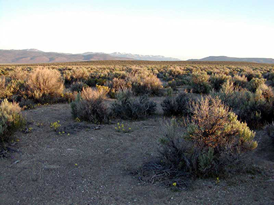 |
| Figure 4—Basin big sagebrush community, Washoe County, Nevada. Soils are sandy and the herbaceous understory is sparse. Photo courtesy of the PRBO Conservation Science Shrubsteppe Monitoring Program. |
Presettlement fire regimes in Wyoming big sagebrush and basin big sagebrush communities are difficult to characterize over large areas because they were spatially and temporally complex due to variation in site characteristics (e.g., topography, soils, vegetation, and fuel structure, composition, moisture content, and continuity), grazing and other disturbance history, climate and weather, and lightning and American Indian ignition rates [14,262,267,280,413]. In addition, records of fire history in Wyoming big sagebrush and basin big sagebrush communities are lacking, and commonly used fire history methods, such as fire-scar analyses, are not possible because big sagebrush plants are killed by fire and hence, do not form fire scars [324]. Instead, inferences suggested by fire adaptations and postfire recovery rates of big sagebrush and associated conifers, and proxy information—including charcoal fragments in soils, wetlands, and lakes; fire evidence from adjacent or intermixed conifers; and historical land-survey records—are supplemented with information on contemporary fires to estimate historical fire regime characteristics [14,186,191]. The fire history of mountain big sagebrush ecosystems is the most well studied of the three major big sagebrush subspecies. Much less is known about fire history in Wyoming big sagebrush and basin big sagebrush ecosystems [260].
Wyoming big sagebrush and basin big sagebrush steppe and shrubland Biophysical Settings mapped by LANDFIRE [230] occur within 24 ecoregions mapped by Omernik and Griffith [288]. Table 2 summarizes data generated by LANDFIRE models for these Biophysical Settings and shows a range of values for fire frequency and severity.
| Table 2—Modeled fire intervals and severities in Wyoming big sagebrush and basin big sagebrush steppe and shrubland Biophysical Settings (BpS). Map zones in bold represent BpSs with conifers included in successional models. Click on the maps for larger images. | ||||||||||||
| Map zones | BpS series | Geographic distributiona | Fire intervalb (years) |
Fire regime group | Citation(s) | |||||||
| Replacement | Mixed | Low | ||||||||||
| Wyoming big sagebrush-basin big sagebrush steppe | ||||||||||||
| 1, 7, 8, 9 | 11250 |  |
48 | 51 | 46 | 3d | III | [224,228] | ||||
| 18, 28 | 11250 |  |
81 | 89 | 11d | 0 | IV | [207,209] | ||||
| 20, 29, 30, 31 | 11250 |  |
90 | 100 | 0 | 0 | IV | [208,227] | ||||
| 6, 12, 15, 16, 17, 23, 24, 25 | 11250 | 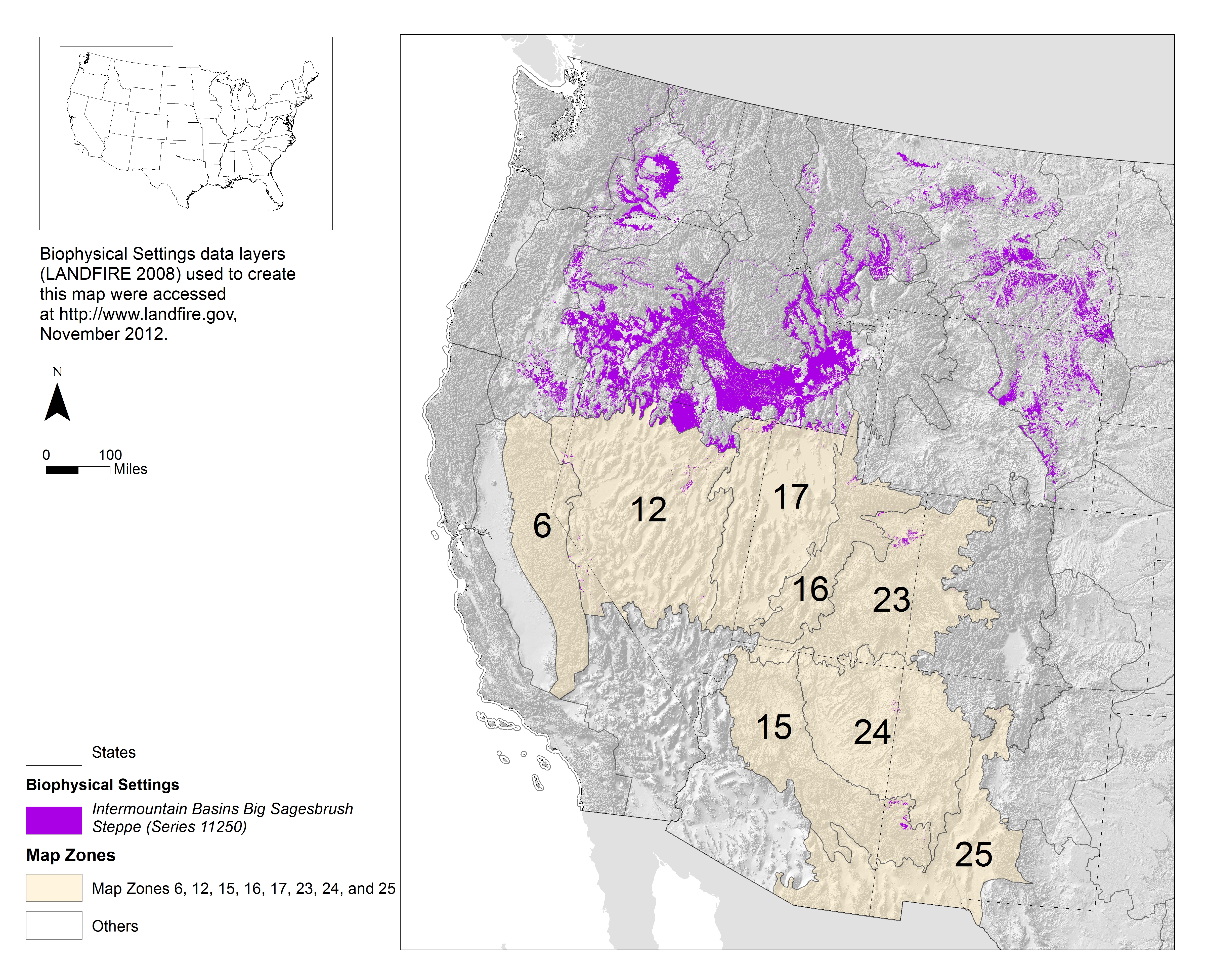 |
92 | 89 | 11d | 0 | IV | [225] | ||||
| 10, 19 | 11250 |  |
93 | 60 | 40d | 0 | III | [226] | ||||
| Wyoming big sagebrush-basin big sagebrush shrubland | ||||||||||||
| 1, 7, 8, 9 | 10800 | 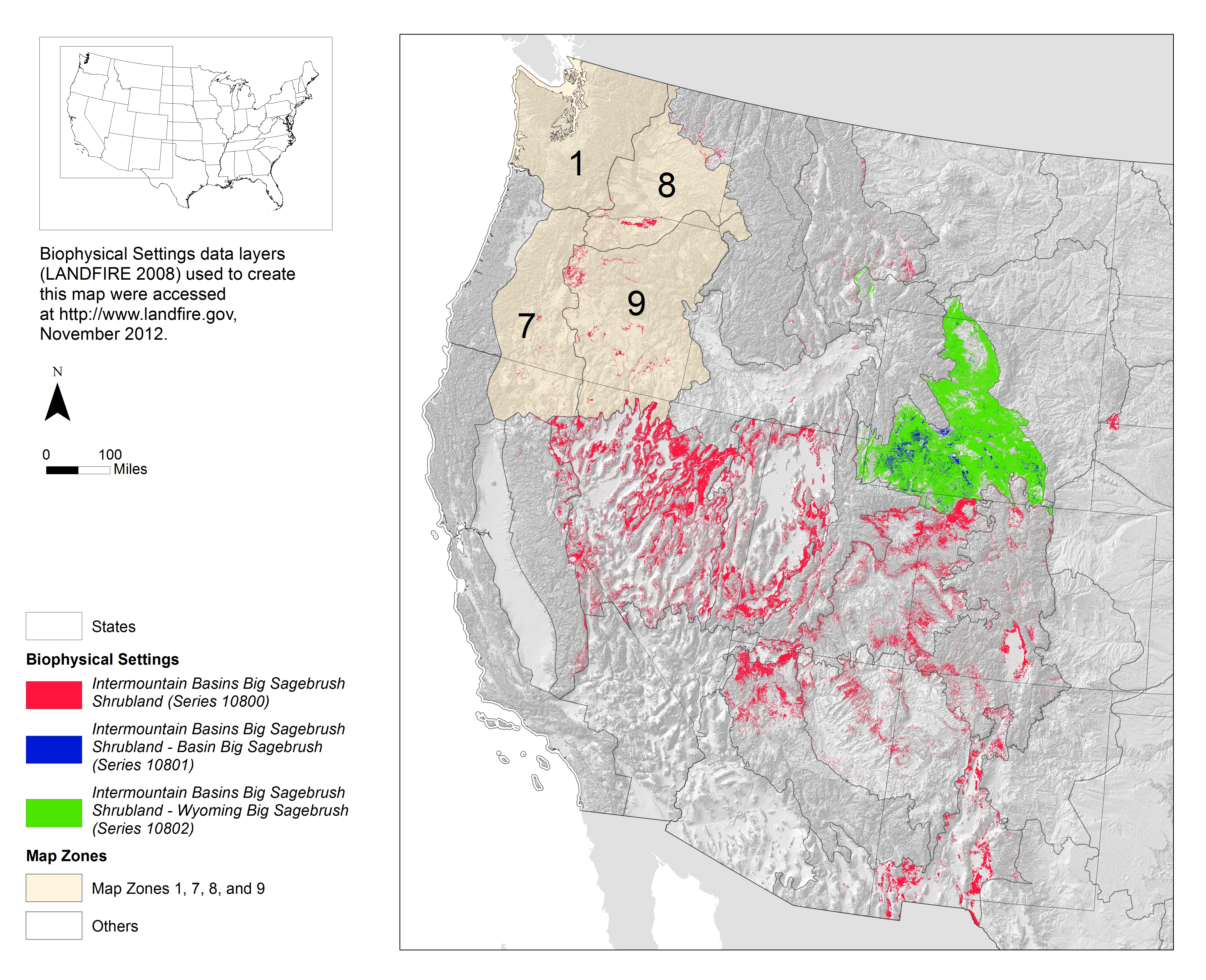 |
33 | 45 | 55d | 0 | I | [212] | ||||
| 33 | 10800 |  |
72 | 76 | 24d | 0 | IV | [223] | ||||
| 21 | 10801 |  |
72 | 100 | 0 | 0 | IV | [217] | ||||
| 10, 19 | 10800 |  |
80 | 100 | 0 | 0 | IV | [210] | ||||
| 28 | 10800 |  |
90 | 76 | 24d | 0 | IV | [221] | ||||
| 31 | 10800 |  |
90 | 100 | 0 | 0 | IV | [222] | ||||
| 15, 25 | 10800 |  |
95 | 76 | 24d | 0 | IV | [215] | ||||
| 21 | 10802 | |
100 | 100 | 0 | 0 | IV | [219] | ||||
| 22 | 10801 |  |
110 | 100 | 0 | 0 | IV | [218] | ||||
| 13, 14 | 10800 |  |
116 | 86 | 10d | 3d | IV | [214] | ||||
| 6, 12, 16, 17, 18, 23, 24 | 10800 |  |
123 | 84 | 11d | 5d | IV | [213,216] | ||||
| 22 | 10802 | |
130 | 100 | 0 | 0 | IV | [220] | ||||
|
aFor maps, numbered, tan polygons show the area covered by the map zone(s) included in the row. Purple shows Intermountain Basins Big Sagebrush Steppe BpSs (series 11250), red shows Intermountain Basins Big Sagebrush Shrubland BpSs (series 10800), blue shows Intermountain Basins Big Sagebrush Shrubland - Basin Big Sagebrush BpSs (series 10801), and green shows Intermountain Basins Big Sagebrush Shrubland - Wyoming big sagebrush BpSs (series (10802).
bMean presettlement fire interval. cPercentage of fires in each of three fire severity classes. Replacement-severity fires cause >75% kill or top-kill of the upper canopy layer; mixed-severity fires cause 26%-75%; low-severity fires cause <26% [24,229]. dThis may be an inaccurate characterization of fire severity and fire regime group for these BpSs. See Presettlement Fire Type, Severity, and Intensity for more information. |
||||||||||||
The close association between sagebrush and woodland cover types in some areas (e.g., [430]) suggests that fire regimes of sagebrush communities prone to conifer expansion be evaluated separately from those not prone to such expansion [191,207,309,359]. LANDFIRE Biophysical Settings models for big sagebrush steppe and shrubland differentiate inconsistently between sites with and without the potential to succeed to conifers. The only Biophysical Settings models for big sagebrush that include pinyons and junipers when big sagebrush communities are adjacent to conifer communities are big sagebrush shrublands in California, the Great Basin, and the Southwest (map zones 6, 12, 13, 14, 16, 17, 18, 23, and 24) [213,214,216]. Some model descriptions mention the presence of or potential for juniper expansion, but they do not include them in models regardless of adjacency (e.g., Biophysical Settings for big sagebrush steppe in parts of the Pacific Northwest (map zones 1, 7, and 9) [224], Northern and Central Rockies (map zone 29), and Northern Great Plains (map zones 30 and 31) [227] and Biophysical Settings for big sagebrush shrublands in the Southwest (map zones 15, 25, and 28) and the Northern Great Plains (map zones 29, 30, and 31) [215,221,222]). Others either do not mention pinyons or junipers in models or model descriptions [210,212,217,218,223], or specifically state that juniper expansion is not a common occurrence [219,220].
Wyoming big sagebrush and basin big sagebrush hybridize with other sagebrush taxa (reviews by [245,389]). Sites occupied by parent taxa and their hybrids may be distinct from one another (e.g., [133,243,244,255,382,395]), but no studies examined fire history of hybrid communities.
Presettlement Fire IgnitionAmerican Indian Ignitions
In the sagebrush biome, American Indians started fires and benefitted from lightning-ignited wildfires. The frequency and purpose of intentional burning varied across the region [3]. Fires were used to improve forage for game, drive game animals, increase production of edible plants and seeds, maintain desirable plant communities, improve visibility, clear campsites, control pests, communicate over distances, and defend against or attack intruders (e.g., [5,25,144,147,149,242,324,345,354,410]). For example, the Kucadikadi, a band of Northern Paiute people who live near Mono Lake in California, held rabbit drives every fall, setting fire to the sagebrush to flush out the animals (Fletcher 1987, cited in [189]). Some intentionally-set fires in sagebrush steppes were relatively large, and multiple fires were often set at once [242]. In the Northwestern Great Plains, American Indians may have intentionally set fires during wet years when fuels were abundant [329].
It is difficult to generalize the effects of burning by American Indians on sagebrush ecosystems because the importance of human-caused fires likely varied "from place to place and culture to culture" [3], and historical records regarding American Indian burning practices are lacking for many tribes in the arid and semiarid regions of the West [410]. In general, American Indian populations in big sagebrush steppe and shrublands were thought to be low prior to European-American settlement [397,399]. Early accounts suggest that American Indian-set fires were rare in the "drier, sagebrush valleys" [147] but perhaps more common at higher elevations, where grass fuels were more abundant [242,345]. Many authors noted potential bias by European-Americans in recording American Indian-set fires, depending on the observer, vegetation type, and season, which makes reliability questionable and interpretation of these early accounts difficult (e.g., [10,144,147,371]). Oral histories from American Indians would be more reliable, but they are too few to draw conclusions regarding fire use in sagebrush communities, and none specifically address Wyoming big sagebrush or basin big sagebrush communities [10]. Anecdotal and ethnographic accounts describing the use of fire by American Indians within the sagebrush biome are reviewed by many authors [147,149,242,345,410], including several chapters (e.g., [10,144,371,406]) in Fire, Native Peoples, and the Natural Landscape (edited by Vale [372]).
Burning by American Indians may have increased fire frequency in some areas [8,144,150], such as in the Middle Rockies [26,184], and the seasonality and size of human-caused fires may have been different from those of lightning-caused fires [8,184,242]. Based on contemporary rates and causes of ignitions, Griffin [144] proposed four hypotheses about American Indian impacts on historical fire regimes in the Great Basin:
Whether American Indian ignitions were less important than lightning ignitions in the West is debated. Some authors suggest that most presettlement fires were lightning-caused [144,151,270], while others suggest that most presettlement fires were human-caused [184,242,354]. For example, a review of fire history in national parks of the Great Plains concluded that while human ignitions were likely locally important, fire frequency was mostly a function of regional climate, with more frequent fire in the south than north and more frequent fire in the west than east [151]. However, in some places, such as Yellowstone National Park, lightning appears insufficient to explain the frequency of fires recorded by fire scars, and ignitions by American Indians have been suggested to explain the difference [10,184]. Authors described the effects of American Indian ignitions as ranging from limited and highly localized (e.g., [10,371,399,400]) to substantial and widespread (e.g., [147,184,242,315,345]). Based on accounts in journals and other historical documents of 145 fires (1776–1900) in Oregon, Idaho, Montana, Wyoming, Utah, and Nevada, Gruell [147] concluded that 41% of fires observed were ignited by American Indians and located primarily at lower and middle elevations, 7% were attributed to other "non-Indian" causes, and no mention of ignition source was made for the remaining 52%. An analysis of American Indian fire use in sagebrush-perennial grass communities concluded that the presettlement Great Basin landscape was a "patchwork of areas altered by aboriginal people and areas shaped primarily by biophysical properties" [242]. American Indian impacts in the sagebrush region were likely concentrated near grasslands, low-elevation forests, and in or near settlement areas (e.g., riparian areas and major river valleys) [25,144,150]. According to West [397], the most important parts of big sagebrush ecosystems to American Indians, as well as early European-Americans, were likely areas of sandy soil or alluvial sites along streams with relatively high cover of grasses and forbs. However, even remote areas were probably touched by American Indian-set fires, at least on occasion, as fires spread from other areas [147].
By the end of the 1700s, American Indian populations throughout the Intermountain West had been reduced by about 80% due to diseases introduced from Europe and other factors [121,273]. While the number of American Indian-set fires was in decline, they were still reported by early explorers and European-American settlers in some parts of the West throughout the 1800s [147]. By the late 1800s, American Indians had been relocated to reservations, and their scope of influence on the landscape was severely diminished [150,264].
Lightning-caused Ignitions
In the West, lightning frequency does not generally limit fire frequency [27,151,195] or interannual area burned [2] at regional scales; rather, fire probabilities are associated with fuel loadings (production and continuity), fuel moisture levels, and lightning arc duration [151,195]. In steppes throughout the Intermountain West, the frequency of lightning ignitions varies spatially and is influenced by geography (i.e., climate and weather patterns), topography, and fuel characteristics. Lightning strike density is apparently not correlated with ignition frequency at regional scales [195], but it likely influences ignition frequency at local scales (e.g., [270]). From 1980 to 1994, ignition frequency in grass-dominated communities of the Intermountain West (native and nonnative grasslands, sagebrush steppes, and conifer savannas) was highest in the western third of the region and in areas with the largest elevational differences (indicative of sites with varied topography) and the most summer precipitation (associated with greater fuel production). In contrast, lightning strike density was greatest in the southeastern part of the region, decreasing steadily toward the northwest, and was not well correlated with ignition frequency. Ignition frequency was greatest in mountainous areas, including the eastern foothills of the Oregon Cascade Range and the Sierra Nevada, and the foothills of the Carson Range in Nevada and California. High ignition frequency also occurred near the Stansbury Mountains in Utah, on the Snake River Plain of Idaho, and in the Ruby Mountains of Nevada. Low ignition frequency was particularly pronounced in the Lahontan Basin in Oregon and Nevada and the Bonneville Basin in Utah [195]. At smaller spatial scales, ignition frequency may be more strongly influenced by lightning strike density, which varies with topographic position. For example, a study in California and Oregon found that among seven mountain big sagebrush/Idaho fescue sites, the site with the most frequent fire (as determined from fire scars on adjacent and intermixed ponderosa pine trees) occurred on a long ridge above a high-elevation tableland—a location that made it highly susceptible to lightning strikes [270]. Information on lightning frequency specific to Wyoming big sagebrush and basin big sagebrush communities was not available as of 2019.
Ignition frequency may be higher in forests than sagebrush communities [14,127,250]. Based on the number of lightning strikes per fire start from 1986 to 1990 in sagebrush (n = 144), Rocky Mountain Douglas-fir (n = 42), and ponderosa pine (n = 24) communities in Idaho reported by Meisner et al. [250], Baker [14] concluded that ignition frequency was three to six times lower in sagebrush than in forest communities.
Presettlement Fire Season
Limited information from fire scars on adjacent and intermixed ponderosa pine trees suggests that fires in Wyoming big sagebrush and mountain big sagebrush communities adjacent to ponderosa pine communities were most common in summer and fall [265,270,298]. A study in Thunder Basin National Grasslands in northeastern Wyoming found that most fires (80%)—as recorded in fire scars from ponderosa pine and Rocky Mountain juniper trees in conifer cover types intermixed with Wyoming big sagebrush communities—occurred during the latter stages of the growing season or during the dormant period [298]. Across seven sites in California and Oregon, fire-scars dated from 1600 to 1830 on ponderosa pine trees within and adjacent to mountain big sagebrush-Idaho fescue communities indicated that most presettlement fires occurred from mid-summer to late fall, particularly in late summer, when dry lightning storms are most common. Only one spring fire occurred in the fire-scar record across the seven sites. However, spring fires probably burned at relatively low intensities, which may have caused less scarring of trees and may underestimate spring fire frequency [270].
Where fire was used by American Indians, American Indian-set fires may have extended the fire season in big sagebrush communities [187,366]. A review concluded that in North America in general, most intentional American Indian-set fires were ignited in spring or late fall, when burning conditions were less severe [187].
While little is known about historical fire seasons, contemporary records of wildfires indicate that peak fire season occurs from April to October, depending on the region, but most wildfires occur in July and August throughout the West. Fire occurrence peaks earliest in the Southwest and progressively later to the north and west [27,237,404]. A study of 410,000 reports of fires that occurred from 1980 to 2001 on lands managed by four of five federal land management agencies in the West found that 94% of lightning- and human-caused fires occurred and 98% of the area burned from May to October, with peak fire activity in July and August. Fire start activity began sooner in Arizona and New Mexico than elsewhere, as early as May and June [404].
Both small and large fires in the Intermountain region of California, Idaho, Oregon, and Utah occur mostly in July and August, although small fires are more widely distributed throughout the fire season. An analysis of fire data (1980–1995) from grasslands, sagebrush steppe, and savanna communities indicated that >82% of large fires (>4,962 acres (2,008 ha)) occurred in July and August. Less than 1% occurred before June and <6% occurred after August. Although 71% of small fires (<0.2 acre (0.08 ha)) occurred in July and August, 7% occurred before June and 15% occurred after August. The timing of median-sized (99.3-297.5 acres (40.2-120.4 ha)) fires depended on location, with fires igniting earliest in the southern part of the region and becoming more common later in the summer in the northern part [196].
Fire season length varies geographically. From 1984 to 2014, the average fire season length calculated for fires ≥1,000 acres (400 ha) was 0 days on the Colorado Plateau (due to the small number of years (n = 10) with at least two fires of this size), 25 days in the Columbia Basin, 72 days in the southern Great Basin, 85 days in the northern Great Basin, 96 days in the Wyoming Basin, 100 in the Great Plains, and 111 days on the Snake River Plain. While the length of the fire season was fairly constant during the 30-year period in many areas, the southern Great Basin (P = 0.02), Great Plains (P = 0.01), and Wyoming Basin (P = 0.02) showed trends of increasing fire season length during the 30 years [69], so contemporary values of fire season length are likely not representative of historical fire season lengths (see Postsettlement Fire Season).
Presettlement Fire FrequencyFire Frequency Summary
Presettlement fire frequency is difficult to estimate in big sagebrush communities because direct evidence of presettlement fires is rare. Fire frequency estimates for big sagebrush communities are based on various sources of information, including contemporary fuel characteristics in big sagebrush communities; fire adaptations and postfire recovery patterns of big sagebrush and conifers; analyses of charcoal fragments in soils or lake and wetland sediments; evidence of fire from adjacent or intermixed conifers; historical land-survey records; and contemporary lightning ignition rates [14,186,191]. Each of these methods has strengths and limitations, and each provides information at particular spatial and temporal scales, all of which are important to consider when applying study results to management questions.
Wyoming big sagebrush and basin big sagebrush communities occur over a productivity gradient driven by soil temperature and moisture regimes. Presettlement fire regimes likely varied across this gradient, with more frequent fires on more productive sites that supported more continuous fine fuels [93,260]. Wyoming big sagebrush and basin big sagebrush are easily killed by fire and do not sprout [75,83,97,122,129,285,296,350,380], and their postfire recovery depends on seedlings establishing and reaching reproductive maturity [177,202,261,279,338,364,434]. Therefore, large, homogenous fires and fires frequent or severe enough to deplete on- and off-site seed sources and prevent establishing plants from reaching maturity are likely to make Wyoming big sagebrush and basin big sagebrush vulnerable to local extinction [73,332,409]. Evidence suggests that large fires were infrequent in big sagebrush communities [14,71,72] and most likely occurred only after 1 or more cool, wet years that allowed fine fuels to accumulate and become more continuous [265].
Postfire recovery time (i.e., the length of time necessary for big sagebrush cover to return to prefire or unburned values) is sometimes used to estimate fire frequency in big sagebrush communities. This is based on the premise that they did not burn, on average, more frequently than the time required for them to recover, but on landscapes prone to conifer expansion, they burned more frequently than the time required for succession to woodland [14,191]. Wyoming big sagebrush postfire recovery data from 112 burned sites in seven ecoregions in 24 studies (table A3) suggest slow postfire recovery of Wyoming big sagebrush cover (fig. 5); no sites recovered within 66 years since fire. However, variability of postfire recovery was high, and two sites neared recovery in 9 years (96% recovery) (fig. A1). Basin big sagebrush postfire recovery data were available from only 10 burned sites in two ecoregions in three studies (table A4). These data showed that postfire recovery of basin big sagebrush is variable but can occur within 26 years since fire.
Six studies used proxy information to estimate presettlement fire frequency in Wyoming big sagebrush and basin big sagebrush communities. Frequency estimates ranged from decades to centuries, depending on scales and methods used and metrics calculated. One study presented information on fire activity derived from charcoal analyses where Wyoming big sagebrush and basin big sagebrush communities occur in the surrounding area. This study was located in the Central Basin and Range ecoregion and suggested that fire activity was episodic and tended to peak during wetter-than-average periods [252] (table A5). Two studies estimated fire frequency from fire scars on ponderosa pine, western juniper, and other trees adjacent to and intermixed with Wyoming big sagebrush communities. These studies, located in the Eastern Cascades Slopes and Foothills and the Northwestern Great Plains ecoregions, found mean fire intervals ranging from 8 to 95 years [298,430] (table A6). No fire-scar studies were available as of 2019 from conifers intermixed with or adjacent to basin big sagebrush communities. Three studies presented estimates of historical fire rotations in Wyoming big sagebrush and basin big sagebrush communities in eight ecoregions using vegetation reconstructions based on Government Land Office survey records from the late 1800s and early 1900s. These studies suggest that fire rotations were shortest in the Middle Rockies and Snake River Plain ecoregions (120-240 years) and longest in the Wyoming Basin (266-533 years) and Colorado Plateaus (178-5,000) ecoregions [7,71,72] (table A7).
Proxy information for Wyoming big sagebrush and basin big sagebrush communities were limited geographically. Data were available from 9 of the 24 ecoregions in which Wyoming big sagebrush and basin big sagebrush communities occur. Only LANDFIRE models provide information on fire frequency in Wyoming big sagebrush and basin big sagebrush communities in all 24 ecoregions. These models estimate mean fire intervals for Wyoming big sagebrush-basin big sagebrush Biophysical Settings that range from 33 years in parts of the Columbia Plateau, Blue Mountains, Eastern Cascades Slopes and Foothills, and Northern Basin and Range ecoregions to 130 years in the Wyoming Basin ecoregion [206] (table 2). Fire managers in underrepresented areas would benefit from fire history studies and information on fine-scale variation in fire frequency due to soil temperature and moisture regimes, which are important drivers of spatial variation in historical fire regimes in sagebrush communities [262].
Introduction
Presettlement fire frequency in sagebrush communities is difficult to estimate because big sagebrush does not record fire scars [324]. In addition, reference conditions are lacking in contemporary big sagebrush stands due to overgrazing and other disturbances related to European-American settlement [401]
(see Distribution).
Thus, fire frequency in these communities is estimated based on inferences suggested by
fuel characteristics
in big sagebrush communities,
fire adaptations and
postfire recovery rates
of big sagebrush [14,75,191,287,393,413,417] and associated conifer species [9,81,160,262,324], and by using proxy information obtained at varying spatial and temporal scales. Proxy information includes:
Each method has strengths and limitations, and the resulting frequency metrics are not directly comparable to one another because they are calculated using measurements from different kinds of fires (e.g., low-severity surface fires and high-severity, stand-replacing fires) and different plant communities (e.g., Wyoming big sagebrush, western juniper, and ponderosa pine), and apply to different spatial and temporal scales [186].
Because methods and studies included differ, previous literature reviews and analyses of published studies on fire history in big sagebrush communities draw different conclusions about historical fire frequency (e.g., [14,108,191,198,267,405]). For example, a 2007 review of studies that used postfire recovery times of big sagebrush and associated conifers to estimate historical fire frequency in big sagebrush communities suggested that historical mean fire intervals in mountain big sagebrush communities and some productive Wyoming big sagebrush and basin big sagebrush communities ranged from 40 to 80 years and were as long as 100 to 200 years or more for relatively unproductive big sagebrush and black sagebrush communities [191]. A 2001 review of three studies on fire history and postfire succession of associated conifers estimated fire intervals of 50 to 100 years in arid Wyoming big sagebrush sites and shorter fire intervals on moister, more productive sites that graded into mountain big sagebrush [267]. A subsequent review of this and other data suggested a fire interval of 30 to 100 years for Wyoming big sagebrush sites, but acknowledged that the estimate was based on "little to no information" [198].
Fuel Characteristics
Researchers frequently infer historical fire frequency in big sagebrush communities from the kind, amount, and continuity of fuels likely present historically. Big sagebrush communities likely had a wide range in amount and continuity of fuels, so a wide range of fire intervals was also likely [92,198,366,378]. Historical fire frequency is estimated by the effects of soil characteristics, climate, elevation, and topography on productivity and fuels [67,91,93,260]. Because warm, dry Wyoming big sagebrush stands tend to be the least productive and cool, moist mountain big sagebrush stands the most productive [119,140,198,261,275,391,412] (table 1), fire frequency is thought to have been least frequent in warm, dry Wyoming big sagebrush stands and most frequent in cool, moist mountain big sagebrush stands [92,142,198,257,260,263]. Fire frequency in basin big sagebrush stands is thought to be intermediate because their productivity is intermediate [332]. Based on this premise, Knick et al. [198] concluded that historical fire intervals in basin big sagebrush communities were probably >50 years, but fires may have been more frequent (10–20 years) on productive sites containing abundant basin wildrye. Wright and Bailey [417] stated that "fire frequency could have been as low as 100 years" in Wyoming big sagebrush sites because they are drier than mountain big sagebrush sites.
Frequent fires may have occurred in big sagebrush communities adjacent to mixed-grass prairies [334]. Differences in fire frequency among Wyoming big sagebrush and basin big sagebrush types in the Northwestern Great Plains in Montana were attributed to fuel loads in adjacent communities and topography. Fire was thought to have been frequent historically on the western portion of Charles M. Russell National Wildlife Refuge, Montana, where Wyoming big sagebrush and basin big sagebrush communities intermix with northern mixed-grass prairie. On these parts of the refuge, frequent fire probably prevented Wyoming big sagebrush and basin big sagebrush from dominating the landscape. On the eastern portion of the refuge, fire was likely less frequent in Wyoming big sagebrush and basin big sagebrush communities "due to the 'badland' landscape, lower fuel loads, and [presence of] fire refugia sites" [334]. Downey (personal communication cited in [208,217]) stated that Wyoming big sagebrush communities in the Northwestern Great Plains in Montana may have burned more frequently (fire interval ~30 years on some sites) than Wyoming big sagebrush in other regions because Wyoming big sagebrush communities commonly occur in a mosaic with mixed-grass prairie, there is "a lot of wind", and topography is "relatively connected" [208] (see Large Fires). During long periods without fire, Wyoming big sagebrush and basin big sagebrush may expand into mixed-grass prairies [222,227]. Where big sagebrush communities grade into desert shrublands, fires were probably rare because of very low fuel abundance [201,300].
Differences in fire frequency between Wyoming big sagebrush and mountain big sagebrush communities on the Snake River Plain were attributed to differences in fuel loads. On the lower Snake River Plain—where Wyoming big sagebrush communities are most common in the region—presence of widely spaced perennial bunchgrasses and discontinuous fuel beds suggest that wildfires were historically uncommon [148,300,405], perhaps with fire intervals from 60 to 110 years [405]. On the upper Snake River Plain—where mountain big sagebrush communities are most common in the region and perennial grasses more abundant—fires were likely more common [300], perhaps with fire intervals as low as 35 years [405]. Hironaka (1992, personal communication cited in [300]) hypothesized that in most years, perennial grass production in Wyoming big sagebrush types on the Snake River Plain was probably <360 pounds/acre (400 kg/ha), so fire spread was limited by sparse fuels. Sites were unlikely to reburn before Wyoming big sagebrush recovered because perennial grass fuels were too sparse for fire to spread without Wyoming big sagebrush fuels under most environmental conditions [300], so fire frequency was determined by the rate of Wyoming big sagebrush postfire recovery.
The kinds of shrubs present historically have been used to infer fire frequency in big sagebrush communities. Rabbitbrush and horsebrush often occur in early-successional stages of big sagebrush communities (e.g., [75,154]). West [397] stated that "fire was apparently not especially frequent or pervasive" in big sagebrush shrubland ecosystems historically because early explorers would have seen more rabbitbrush, horsebrush, or other sprouting shrubs on the landscape instead of big sagebrush if fire had been frequent (every 20-25 years). Wright and Bailey [418] suggested a fire interval of at least 50 years "based on the vigorous response of [spineless horsebrush] to fire and the 30-plus years that are needed for it to decline to a low level after a fire" in mountain big sagebrush communities in eastern Idaho. Daubenmire [114] stated that because fire readily kills both big sagebrush and antelope bitterbrush, "their early widespread distribution disproves any opinion as to the omnipresence of fire" at the time of early European-American exploration of the West.
Because big sagebrush steppe is more productive than big sagebrush shrubland, big sagebrush steppe likely burned more frequently. "Based on what has been shown through different approaches and field experience of those who know the system", Kitchen (personal communication cited in [220]) estimated a fire interval of 60 to 120 years for relatively productive Wyoming big sagebrush steppe and 75 to 200 years for Wyoming big sagebrush shrubland.
Because precipitation affects the amount of fuels in Wyoming big sagebrush and basin big sagebrush sites [252,261,307,403] (see Presettlement fuels: Amount and Continuity of Fuels), fire likely occurred at variable intervals depending on local weather patterns.
Fire Effects
Plant response to fire
Wyoming big sagebrush and basin big sagebrush plants are easily killed by fire [75,83,97,122,129,285,296,350,380]; they do not sprout [155,284,413]. Thus, fire reduces their cover and density [49,75,83,263,284,332,350,351,418], and postfire establishment is dependent on on-site or nearby off-site seed sources [177,202,261,279,338,364,434]. Seeds may germinate from short-lived soil seed banks [28,274,279,340,364,409,431] if they survive fire and are not buried too deeply. Big sagebrush seed production is highly variable, and depends on plant characteristics (e.g., size, age, and genetics), weather, and site characteristics (e.g., soil temperature and moisture regimes) [143,155,246,254,274,387]. Surviving plants in unburned patches may produce abundant seeds in favorable years [155,274,433]. Most big sagebrush seeds fall within 10 feet (3 m) of parent plants [135,155,364,374,392,431], so postfire recovery on large burns may be slow.
Postfire seedling establishment of Wyoming big sagebrush and basin big sagebrush is highly variable [30,31,103,234,332,348,383,402,433]. If postfire moisture conditions are favorable and big sagebrush establishes soon after fire, its rate of postfire recovery may be relatively rapid. If it does not establish soon after fire, other species may establish first and reduce the availability of suitable sites for germination, thus slowing the rate of postfire recovery [98]. Once Wyoming big sagebrush and basin big sagebrush reach reproductive maturity (anywhere from 2 (e.g., [387,432,433]) to >10 (e.g., [379]) years old), they contribute to postfire recovery. Postfire recovery is inhibited when fire recurs before big sagebrush seedling cohorts reach maturity. Thus, fire intervals frequent enough to kill plants before they reach maturity and large, severe fires that deplete on- and off-site big sagebrush seed sources may make big sagebrush vulnerable to local extinction [73,332,409]. See the Species Reviews about Wyoming big sagebrush and basin big sagebrush for details and documentation of the fire ecology of these subspecies.
Fire adaptationsPostfire recovery
Postfire recovery time (i.e., the length of time necessary for big sagebrush cover to return to prefire or unburned values) is sometimes used to estimate fire frequency in big sagebrush communities based on the premise that big sagebrush communities burned, on average, less frequently than the time required for them to recover [14,191], but on landscapes prone to conifer expansion, more frequently than the time required for them to succeed to woodland [191]. Baker [14] reviewed 10 postfire recovery studies with cover and density data from ~70 Wyoming big sagebrush sites in the Colorado Plateaus, Middle Rockies, Northwestern Great Plains, and Snake River Plain ecoregions and 11 postfire recovery studies with cover and density data from >56 mountain big sagebrush sites in the Middle Rockies and Snake River Plain. He did not examine postfire recovery studies with basin big sagebrush or differences among ecoregions. He found that Wyoming big sagebrush recovery after fire is highly variable and often slow. Overall, Baker estimated 50 to 120 years for full recovery of Wyoming big sagebrush, with faster recovery possible on some "exceptional" sites, but he acknowledged that "evidence is too limited to accurately estimate the time for full recovery of Wyoming big sagebrush after fire". For mountain big sagebrush sites, he found that 16 sites showed nearly full recovery 25 to 30 years since fire; he classified these as "fast track" sites. The remaining sites had not recovered up to 35 years since fire, and Baker estimated that those >40 sites would require 75 or more years to reach full recovery; he classified these as "slow track" sites. Based on these observations and his suggestion that a conservative estimate for "fire rotation and [point] mean fire interval for sagebrush [is] at least twice the recovery period", he suggested a fire rotation or
point fire interval
of at least 50 to 70 years for fast track mountain big sagebrush sites and at least 150 to 200 years for slow track sites [14]. An equivalent estimate for Wyoming big sagebrush sites would be 100 years for fast track sites and 240 years for slow track sites.
The 2019 FEIS Species Review about Wyoming big sagebrush included a review and analysis of Wyoming big sagebrush postfire recovery data from 112 burned sites in seven ecoregions examined in 24 studies (table A3). These analyses showed slow postfire recovery of Wyoming big sagebrush cover, overall (fig. 5). When Wyoming big sagebrush cover and postfire recovery were plotted against time-since-fire for each ecoregion, postfire recovery appeared slow on all sites in all ecoregions, except on five sites in the Middle Rockies ecoregion that neared recovery (fig. A1). However, differences in the number of study sites and time-since-fire made it difficult to compare recovery among ecoregions. For example, only two ecoregions had study sites that exceeded 20 years since fire. Data from sites in these ecoregions showed that 3 of 27 sites in the Middle Rockies neared recovery (within 90%) 9 to 33 years since fire [232,249,296,376,380,384] (fig. A1c), while no sites in the Northwestern Great Plains neared recovery within 66 years since fire [51,103,106,122] (fig. A1e). Sites in the Middle Rockies nearing recovery were relatively moist [235,376], suggesting that Wyoming big sagebrush cover might occasionally recover on relatively moist Wyoming big sagebrush sites within about 33 years. While some sites in the Northwestern Great Plains were dry, others were relatively moist [51,103,104,122], yet no sites >20 years since fire had recovered [106]. While a few sites in the Middle Rockies ecoregion showed relatively fast recovery, most were slow to recover. For example, one site had <0.2% Wyoming big sagebrush cover 23 years since fire [232], and another had 0% Wyoming big sagebrush cover 19 years since fire [249]. Heavy browsing of Wyoming big sagebrush by wild ungulates may have contributed to slow recovery on some sites in the Middle Rockies ecoregion (e.g., [249]), while heavy postfire browsing by wild ungulates was not mentioned in studies of Wyoming big sagebrush with the highest postfire recovery [234,376,384]. According to LANDFIRE, fire intervals on big sagebrush steppe and shrubland sites in the Middle Rockies (map zones 19 and 21) ranges from 72 to 100 years [210,217,219,226], which is similar to fire frequency in the Northwestern Great Plains (map zones 20 and 29; 90 years) [208,227] (table 2). A direct relationship between postfire recovery and fire frequency [14,417] suggests relatively similar postfire recovery times in these two ecoregions.
 |
| Figure 5—Mean ratio (SE) of burned to unburned (or prefire) cover (i.e., "postfire recovery") of Wyoming big sagebrush within 5-year, time-since-fire bins. The red line indicates recovery to unburned (or prefire) cover [170]. |
Only three studies examined postfire recovery of basin big sagebrush (table A4). These indicate that postfire recovery of basin big sagebrush is highly variable but can occur within 26 years since fire [83,234,249]. For example, Lesica et al. [234] reported postfire recovery of basin big sagebrush on four sites and found that one site had 25% basin big sagebrush cover on burned plots 26 years since fire, which exceeded basin big sagebrush cover on paired, unburned plots (16.16%). Another site had not recovered to unburned values 30 years since fire (10.0% on burned plots; 24.7% on unburned plots).
Wyoming big sagebrush is expected to have a longer postfire recovery time than mountain big sagebrush and basin big sagebrush because it occurs on the warmest, driest sites [52,54,63,65,75,249,261,378]. The reviews and analyses of postfire recovery data in the 2019 Wyoming big sagebrush Species Review and the 2017 mountain big sagebrush Species Review supported this expectation. The former showed slow postfire recovery of Wyoming big sagebrush cover (fig. 5), while the latter showed that mountain big sagebrush sites tended toward full recovery at 26 to 30 years since fire. Not enough data were available on basin big sagebrush postfire recovery to draw a conclusion about its postfire recovery relative to the other major subspecies. Only two studies examined differences in postfire recovery among the three major big sagebrush subspecies. A study on the northern Yellowstone winter range examined postfire recovery 19 years after a wildfire and found that Wyoming big sagebrush was the slowest to recover (2%) of the three subspecies; mountain big sagebrush (12%) and basin big sagebrush (16%) recovered at similar rates. The authors concluded that Wyoming big sagebrush recovery may have been slowest because it occurs on the driest, least productive sites. In addition, because these sites are free of snow longer, Wyoming big sagebrush plants are more heavily browsed than mountain big sagebrush and basin big sagebrush plants that occur in areas that retain more snow, such as on north- and east-facing slopes and depressions [249,379]. Lesica et al. [234] compared postfire recovery after wild and prescribed fires at 6 Wyoming big sagebrush sites, 4 basin big sagebrush sites, and 28 mountain big sagebrush sites in southwestern Montana. They found that the average time to full postfire recovery was slowest for Wyoming big sagebrush, intermediate for mountain big sagebrush, and fastest for basin big sagebrush. They attributed the quick recovery of basin big sagebrush cover to its fast growth relative to the other subspecies [234].
Infrequent fire in big sagebrush communities is sometimes inferred by the presence of junipers and pinyons because they are susceptible to fire when young [9,81,160,262,324,430]. For example, because western juniper trees <50 years old are easily killed by fire, several authors inferred that mean fire intervals of <50 years would inhibit woodland expansion into sagebrush communities [81,324,430].
While juniper and pinyon establishment in big sagebrush communities may be "minimal" on many sites even after long periods without fire [192], they can establish and dominate in big sagebrush communities along woodland-sagebrush ecotones when the interval between fires becomes long enough, conifer seed sources are available, and environmental conditions are suitable [192,263,430] (see Woodland Expansion). The time required to transition between phases in woodland succession is variable and depends on the sagebrush taxon and site characteristics. Although not reported for Wyoming big sagebrush communities, successional advancement from mountain big sagebrush and low sagebrush communities to western juniper woodlands (Phase I to Phase III) varied from 60 to 80 years on cool, moist sites to >125 years on warm, dry sites in southeastern Oregon and southwestern Idaho [175,260]. Researchers developed a chart for mountain big sagebrush communities with varying productivity that predicts the number of years necessary to transition from initial western juniper establishment to development of late-successional woodlands. Rates of succession vary with elevation and insolation exposure, with fastest development on high-elevation, low-exposure sites (i.e., cool, relatively moist sites) (~70 years) and slowest development on low-elevation, high-exposure sites (i.e., warm, dry sites) (~130 years) [175,260] (fig. 6). This suggests that Wyoming big sagebrush communities on warm, dry sites would take longer—likely >125 years—to succeed to late-successional western juniper woodlands than those on cooler, moister sites.
 |
| Figure 6—Hypothesized number of years from initial western juniper establishment (early Phase I) to development of late-successional woodland (Phase III), and estimated maximum density and cover of western juniper for stands developing on mountain big sagebrush sites with varying elevation and insolation exposure (i.e., a gradient of relatively cool/moist to warm/dry sites) [175,260]. |
Charcoal Analyses
Analyses of charcoal fragments from soils [283] or lake and wetland sediments [252] can be used to reconstruct fire history within treeless landscapes. The spatial resolution of these fire histories may be similar to that of fire histories derived from fire-scar analysis (i.e., the site of the soil sample or the watershed of the lake or wetland). However, the temporal resolution depends on sedimentation rates as well as the continuity or number of samples analyzed, and can range from years to centuries [205]. Individual fires cannot usually be resolved from charcoal analyses, but peaks in charcoal abundance or accumulation rates indicate fire "events" or "episodes"—when one or more fires occurred within the time period spanned by the peak—and can be related to changes in fire activity at the site or landscape level [283]. Nelson and Pierce [283] caution that fire frequency estimates obtained from charcoal in sediments and those obtained using fire-scar records should be compared cautiously because of the different temporal resolutions. Additionally, analysis of charcoal peaks is biased toward detection of high-severity crown fires, because low-severity surface fires contribute primarily to background charcoal levels and may not leave distinct peaks [407], while fire scars record low- to moderate-severity surface fires.
Only a few fire history studies using charcoal fragments in soils or sediments had been conducted in sagebrush landscapes to date (2019) (e.g., [165,171,252,283]), and only one [252] provides fire history information for a site where Wyoming big sagebrush and basin big sagebrush communities occur in the surrounding area (table A5). This fire history was derived from a permanent spring (Newark Valley Pond) in central Nevada in the Central Basin and Range ecoregion and covers 5,500 years. Vegetation reconstructions based on analyses of pollen suggest that sagebrush was a common to dominant component of the vegetation during that time [252]. Records of fire activity suggest that fire frequency ranged from about 10 fires per 1,000 years (5,500 to 5,000 cal yr BP) to only 2 fires per 1,000 years (4,000 to 1,000 cal yr BP). More fires occurred during periods when sagebrush was more abundant, and fewer fires occurred when salt desert shrubs were more abundant. These results suggest fire intervals of 100 years or more in Wyoming big sagebrush and basin big sagebrush [252].
Comparisons of peaks in charcoal abundance with climate records suggest that sagebrush densities and fire occurrences increased during periods that were wetter than average, implying that sagebrush communities are fuel-limited systems. Fine-fuel biomass increases during relatively wet periods and is then ignited during subsequent, relatively dry years [171,252,283]. For example, charcoal records from Newark Valley Pond indicate that the period with the most frequent fire coincided with a period of wet climate in the Great Basin occurring about 5,000 cal yr BP. The period with the least frequent fire coincided with a period of extended drought occurring from 2,600 to 1,600 cal yr BP [252]. The positive relationship between fire occurrence and relatively wet periods has also been described in landscapes dominated by mountain big sagebrush in northwestern Wyoming [171] and southwestern Idaho [283]. For example, in a southwestern Idaho rangeland, a comparison of fire activity (based on radiocarbon dating of charcoal in soil) to climate reconstructions (based on tree-ring records) over the last 2,000 years showed that fire episodes were more common during centuries that were wetter than average, and that fire activity peaked during drier than average decades within those centuries. For example, fire episodes were frequent during the cool and wet Little Ice Age (AD 1350–1850) and most frequent around AD 1450—a period with several drier than average decades. In contrast, fire episodes were infrequent during the relatively dry Medieval Climatic Anomaly (AD 925–1280), with the exception of a wetter interval centered in AD 1100, when some fire activity was evident [283].
Fire-scar Records
Fire interval estimates for big sagebrush communities derived from fire-scar records on recording trees intermixed with or adjacent to big sagebrush communities are widely cited in the literature, especially for mountain big sagebrush communities, but also some Wyoming big sagebrush communities. However, limitations of this approach have led to criticisms from several authors. Uncertainty regarding the frequency at which fires spread across ecotones between woodlands or forests and big sagebrush communities makes the applicability and interpretation of fire-scar records for big sagebrush communities uncertain because "a fire on a nearby tree may not always have burned the sagebrush" [11] (e.g., [11,366,378,393]). Observations at forest and woodland ecotones with mountain big sagebrush communities in Utah, Nevada [192], Oregon, and California [270] suggest that presettlement fires may have spread across these ecotones (see Presettlement Fuels:
Amount and Continuity of Fuels).
However, no such observations have been published regarding fire spread across forest and woodland ecotones with Wyoming big sagebrush or basin big sagebrush communities, which are generally less productive than mountain big sagebrush communities. In addition, adjacent forest and woodland types vary across the range of big sagebrush sites, and each has different historical fuel and fire regime characteristics. Therefore, results from individual studies may not be applicable to other locations. For example, a northeastern Wyoming study that used fire-scar records on ponderosa pines and Rocky Mountain junipers suggests relatively short fire intervals for Wyoming big sagebrush communities [298]. However, proximity to fire-prone ponderosa pine forest may have led to more frequent fires in these and other sagebrush landscapes [185] than in those adjacent to less fire-prone types (e.g., pinyon-juniper) and those far from woodlands and forests. In addition, suitable proxy trees are absent from many big sagebrush sites and, where they are present, are often scarce and disproportionately distributed, so sample sizes are often small [191]. In some cases, associated trees may be located on "fire safe" sites such as rocky ridges with sparse fine fuels (e.g., [81]) that are not representative of big sagebrush sites [148,252,265].
Fire-scar records from conifers intermixed with or adjacent to Wyoming big sagebrush communities were available from two sites in two ecoregions and published in two studies [298,430] (table A6). In Lassen County, California, there was no evidence of fire in a Wyoming big sagebrush community and few western junipers were present prior to European-American settlement. However, fire scars on western junipers in a nearby western juniper-low sagebrush community indicated fire intervals ranging from about 10 to 95 years prior to settlement. The authors suggested that some or all of these fires may have spread into the Wyoming big sagebrush community [430]. A study in Thunder Basin National Grasslands found a Weibull Median Probability Interval of 7.9 years prior to European-American settlement across ponderosa pine, Rocky Mountain juniper, and ponderosa pine/Rocky Mountain juniper forest cover types. Ponderosa pines with the most fire scars from different fire years occurred on the eastern slope of the Rochelle Hills escarpment, where the ponderosa pine/bluebunch wheatgrass type was most prevalent. Wyoming big sagebrush occurred in canopy openings in this type. This type had the highest herbaceous biomass production among the three forest cover types, and such frequent fire probably maintained an understory of grasses with sparse Wyoming big sagebrush [298]. Data are too limited to draw conclusions about differences among studies. As of 2019, no fire-scar studies had been conducted using conifers intermixed with or adjacent to basin big sagebrush communities.
Fire Rotation Estimates
Fire rotation is the time it takes to burn an area equal to a landscape of interest [328]. Baker [16] calculates fire rotation by adding the areas of individual fires (surface and stand-replacing fires) in a particular area over some period of time, and dividing this time period by the fraction of the total area burned. For example, a fire rotation of 100 years means that fire will burn an entire landscape over a 100-year period and that each point on the landscape will burn, on average, once during that period [12]. Fire rotation is best calculated for an area that exceeds the largest fire expected in one rotation [263], and accurate estimates of fire rotation require a period of record at least as long as the fire rotation estimates, which is seldom available [7,72]. Because fire rotations do not directly consider variation across space or time, Miller et al. [263] considered them best used to examine relative differences among regions or relative changes within a particular region, noting that a region typically encompasses a range of plant associations and ecological sites. Thus, it is important to know something about the composition of plant associations and ecological site types included within the area being studied. Romme et al. [327] stated that sagebrush communities are “very heterogeneous, and a single, broad characterization of historical fire rotations cannot adequately convey the complex historical role of fire in these ecosystems”.
Fire rotations estimated using land-survey records
General Land Office surveys are limited both spatially and temporally, and the quality and validity of surveys vary, with information in survey notes sometimes ambiguous. For example, surveys are not available for all townships, and the period of observation in available surveys is limited to a few decades, while accurate fire rotation estimates require a period of record at least as long as the fire rotation estimates [7,72]. Presettlement fire rotations estimated from vegetation reconstructions based on General Land Office survey records from the late 1800s and early 1900s were available for eight ecoregions. These estimates suggest that presettlement fire rotations in Wyoming big sagebrush and Wyoming big sagebrush-basin big sagebrush landscapes varied widely among these ecoregions
(table A7).
Bukowski and Baker [71,72] and Arendt [7] used vegetation descriptions in General Land Office surveys to reconstruct historical vegetation over large landscapes, and they used these reconstructions to identify burned areas. Burned areas were then used to calculate fire rotations in Wyoming big sagebrush landscapes that ranged from 10s of thousands to 100s of thousands of acres and encompassed a range of soil temperature and moisture regimes. Estimates ranged from 120 to 240 years for 1.1 million acres (0.5 million ha) in the Middle Rockies and Snake River Plain ecoregions to 266 to 533 years for 0.6 million acres (0.2 million ha) in the Wyoming Basin [71,72]. The authors state that all of the fire rotation estimates were likely long enough to allow full
postfire recovery
and extended periods of dominance by Wyoming big sagebrush [71]. "No clear explanation" was apparent for the very long fire rotations in the Wyoming Basin, although they suggest that the dry climate [72], the relatively complex topography, and the sparse, fuel-limited dwarf sagebrush communities in that ecoregion [15] contributed
(see Postsettlement Fire Pattern and Size).
Fire rotation ranged from 2,500 to 5,000 years for Wyoming big sagebrush-basin big sagebrush landscapes in an unknown portion of Dinosaur National Monument and surrounding areas in Colorado and Utah [7]. Arendt did not provide an explanation for the very long fire rotation in this area.
Fire rotations in big sagebrush within a matrix of pinyon-juniper woodlands
Baker [14] suggested that small patches of big sagebrush within a matrix of pinyon-juniper woodland would have burned at the same frequency as the surrounding woodland. Fire rotations and fire cycles of ~290 to 650 years were estimated for stand-replacement fires in pinyon-juniper with Wyoming big sagebrush and/or basin big sagebrush in these communities in the Central Basin and Range [37] and Colorado Plateaus [130,131,166,347] ecoregions
(table A8).
Fire rotations estimated using conversion factors
In 2006, Baker [11,12] introduced the concept of using multipliers:
Baker [14] applied his conversion factors of 3.6 and 16.0 to fire frequency estimates published in one study (i.e., [430]) to estimate fire rotation in Wyoming big sagebrush communities, and he presented these data in a table (table 11.1, pg. 192) [14]. This application is problematic. The conversion factors were intended to convert composite fire intervals to fire rotations, but Baker applied them to an estimate (95 years) that was based not on composite fire intervals, but on fire scars from one tree with two trunks that grew from 1655 to 1750 without scarring and then subsequently was scarred in the decades of the 1770s, 1780s, 1790s, 1830s, and 1850s. In addition, these data were obtained from a western juniper-low sagebrush community, not the adjacent western juniper/Wyoming big sagebrush community, from which no fire-scarred trees were obtained due to the lack of presettlement trees [430]. Furthermore, the relationship between fire frequency in conifer communities and "sagebrush" communities in general, from which the conversion factor of 0.57 was derived, likely differs from that between conifer communities and Wyoming big sagebrush communities in particular.
Additionally, McAdoo et al. [242] noted that Baker's [11,14] conversion factors are based on relationships between metrics from contemporary fires in landscapes with a history of grazing and altered species compositions, so they may not represent presettlement relationships.
Presettlement Fire Type, Severity, and Intensity
Presettlement wildfires in Wyoming big sagebrush and basin big sagebrush communities were standing replacing [11,14] because fire easily kills Wyoming big sagebrush plants.
However, fire severity on other ecosystem components (e.g., understory vegetation and soil) varies due to variation in fuels, topography, and weather. Variability in fire severity results in a mosaic of burned and unburned patches [14]. Within burned patches, nearly all Wyoming big sagebrush and basin big sagebrush plants are killed (e.g., [32,33,52,96,123,128,301,380,416,422]). Because big sagebrush's cover and density are typically reduced by >75% in burned areas (e.g., [11,96,103,122,234,308]), presettlement fires are considered high-severity, or stand-replacement fires by LANDFIRE's definition [24,229].
Like contemporary wildfires (e.g., [103,114,122,233,249,277,321,379]), presettlement wildfires in big sagebrush communities are thought to have been replacement severity [11,14,19,324]. While fires in big sagebrush communities may leave patches of unburned vegetation within fire perimeters (i.e., mosaic fires) (e.g., [83]), they are not mixed-severity fires by LANDFIRE's definition [24,229]. Studies of contemporary fires in Wyoming big sagebrush and basin big sagebrush communities typically do not report fire severity. Of those that do, most describe >75% reduction of big sagebrush cover in burned areas following both wildfires [46,122,233,249,277,299,308,390] and prescribed fires [52,97,233,296,299,313,332]. Studies of prescribed fires that created mosaics in Wyoming big sagebrush communities in southeastern Oregon [422] and a mountain big sagebrush community in western Wyoming [316] found that nearly all biomass was consumed in burned portions of the mosaics (see Presettlement Fire Pattern and Size for more information about mosaic fires).
Most LANDFIRE models place Wyoming big sagebrush and basin big sagebrush steppe and shrubland Biophysical Settings in fire regime group IV. This group is characterized by replacement-severity fires, and models estimate that 76% to 100% of fires are of replacement severity. However, some models estimate that 40% to 55% of fires are of mixed severity, and place these Biophysical Settings in fire regime groups I and III (table 2). LANDFIRE defines mixed-severity fires as those that top-kill 25% to 75% of the dominant life form (e.g., shrubs in a shrubland), whereas replacement-severity fires top-kill >75% of the dominant life form and low-severity fires top-kill <25% of the dominant life form [211]. Using this definition of mixed-severity fire, FEIS Species Reviews of fire history studies in Wyoming big sagebrush [170], basin big sagebrush [363], and mountain big sagebrush communities [169], and a review by Baker [11], found no evidence of mixed-severity fire historically, suggesting that all big sagebrush steppe and shrubland Biophysical Settings should be placed in replacement severity fire regime groups.
Fire intensity depends on fuel characteristics, weather, and topography. While a review by Miller et al. [270] of fire regimes in mountain big sagebrush communities describes presettlement fire intensity as mostly low—based on the assumption that these communities typically had abundant, continuous fine fuels and widely scattered, patchy shrub cover, a review by Riegel et al. [324] of fire regimes in Wyoming big sagebrush, basin big sagebrush, and mountain big sagebrush communities described presettlement fire intensity as mostly moderate, presumably for areas with relatively abundant shrub cover. Intensity of individual contemporary fires in sagebrush communities ranges from low to high due to variation in fuel characteristics, weather, and topography [333,341]. Brown [70] quantified fuel properties and modeled fire behavior for Wyoming big sagebrush and mountain big sagebrush in Montana and Idaho to show how rate of spread and fireline intensity varied with big sagebrush height, percent cover, foliage moisture, and fraction of dead stemwood. Modeled fireline intensity for big sagebrush greater than ~24 inches (60 cm) tall was low (~500 kW/m) when vegetation was green in spring and moderate (~2,000 kW/m) when 33% of the vegetation was cured or dead in fall. However, observed fireline intensity during four prescribed fires in a variety of sagebrush communities indicated that modeled fireline intensities were three to six times lower than those observed in the field [70]. Fireline intensity in basin big sagebrush communities was moderate (880 kW/m) in a spring prescribed fire and high (6,400 kW/m) in a fall prescribed fire in Oregon due to greater total aboveground biomass and lower fuel moisture content in the fall fire, although percent consumption of total biomass was not different between spring (84%) and fall (93%) fires [333]. See the Research Project Summary of Sapsis and Kauffman's [332,333] study for information on the fire prescriptions, fire behavior, and details of postfire responses of basin big sagebrush and about 60 other plants. Fireline intensity during prescribed fires is likely lower than is typical during late-summer wildfires [422]. Scott and Burgan [341] provide fire behavior fuel models that can be used to predict spread rate and intensity of fires in sagebrush ecosystems for a range of conditions.
Presettlement Fire Pattern and Size
Although it is difficult to reconstruct the sizes and shapes of past fires in big sagebrush communities [11,14], fire size distributions estimated using General Land Office survey records from Colorado [71], Idaho, Nevada, Oregon, and Wyoming [72] suggest that fires in big sagebrush ecosystems were mostly small (less than ~1,200 acres (500 ha)), and that large fires (>24,700 acres (10,000 ha)) were infrequent. For example, using General Land Office survey records from 1872 to 1892 to reconstruct historical vegetation patterns in west-central Colorado, Bukowski and Baker [71] identified areas thought to have burned within 541,000 acres (219,000 ha) of Wyoming big sagebrush, mountain big sagebrush, mixed sagebrush-mountain shrubland, and associated grassland communities. Based on those reconstructed presettlement fires, they inferred a pattern of mostly small fires, with infrequent large fires. This fire-size distribution was inverse-J shaped, with a geometric mean patch size of 380 acres (154 ha) and mean fire size of 524 acres (212 ha). Analyses of presettlement fires >1,200 acres (500 ha)) suggested that these fires had little unburned area within fire perimeters (<4%), although the authors cautioned that the amount of unburned area may have been underestimated due to the coarse resolution of the land-survey records. The amount of unburned area in smaller fires could not be determined [71]. Using similar methods, these authors inferred similar presettlement fire patterns and sizes within >5.4 million acres (2.2 million ha) of Wyoming big sagebrush, mountain big sagebrush, and other sagebrush communities in Idaho, Nevada, Oregon, and Wyoming [72].
No studies provided information on presettlement fire sizes and patterns in landscapes dominated by individual big sagebrush subspecies as of 2019. Fire pattern and size likely differed among sites dominated by each of the three major big sagebrush subspecies because the sites differed in the amount and continuity of fuels. For example, warm, dry Wyoming big sagebrush sites likely had patchier and less continuous fine fuels than relatively cool, moist mountain big sagebrush sites [76,258,259,260], and therefore may have had more unburned area within fire perimeters.
As of 2019, studies about fire size were lacking for Wyoming big sagebrush and basin big sagebrush communities in particular. Sizes of contemporary fires may be used to infer sizes of presettlement fires. In contemporary sagebrush communities, small fires are far more common than large fires [127,157]. For example, from 1992 to 2012, 33,782 fires occurred in greater sage-grouse habitat in the West. During this time, 53% were <1 acre (0.4 ha), 79% were <10 acres (4 ha), and 97% were <1,000 acres (405 ha); only 0.7% were >10,000 acres (4,047 ha) [157]. Analyses from national forests in Colorado suggested that small fires (<10 acres (4 ha), 91%) were more common than large fires (≥10 acres and <300 acres (120 ha), 9%) in "grass-sage" communities, and large fires accounted for only 13% of the total area of grass-sage communities that burned from 1960 to 1973 (2,525 acres (6,239 ha)) [127]. From 1984 to 2014, 1,640 fires >1,000 acres (405 ha) burned >7 million acres (3 million ha) within Sage-grouse Priority Areas for Conservation in seven states, but only 17 of these fires accounted for 25% of the burned area [89]. However, contemporary fires likely differ from presettlement fire sizes where fire suppression, cheatgrass invasion, livestock overgrazing, and/or habitat fragmentation occur [125,356] (see Postsettlement Fire Pattern and Size).
Reviews state that because of sparse and discontinuous fuels, wildfires in big sagebrush communities were likely patchy, mosaic fires, particularly in Wyoming big sagebrush communities. However, large and more complete fires occasionally occurred after periods of wet weather that allowed fine fuels to accumulate and become more continuous [198,261] (see Large Fires). Contemporary fires in Wyoming big sagebrush and basin big sagebrush communities with sparse and/or patchy fuels are typically patchy, but within burned patches, nearly all big sagebrush plants are killed (e.g., [33,52,58,96,123,128,380,416,422]). At Hart Mountain National Antelope Refuge, Oregon, for example, September prescribed fires in a Wyoming big sagebrush community resulted in a mosaic of burned and unburned patches. In burned patches, 60% to 90% of herbaceous plant cover was consumed, and 100% of the Wyoming big sagebrush cover was consumed [422]. See the Research Project Summary of Wrobleski and Kauffman's [421,422] study for information on the fire prescriptions, fire behavior, and details of postfire responses of Wyoming big sagebrush and many other plants in the sagebrush community.
The habitat requirements of sagebrush obligates also suggest that mosaic fires were common historically. A review of ecological literature, historical accounts, and explorer reports concluded that bird communities in sagebrush habitats depend on a mosaic of native plant communities and successional stages and that "spotty and occasional wildfire probably created a patchwork of young and old sagebrush stands across the landscape" prior to European-American settlement [290]. Greater sage-grouse prefer large, contiguous sagebrush habitats of varying cover and density with small, scattered openings [124,295], suggesting that large, homogeneous fires were rare [185]. The relative abundance of pronghorn in some areas of the Great Basin prior to European-American presettlement suggests that fires were patchy historically [242], because pronghorn generally benefit from fires that create openings in dense sagebrush habitats [162,188,426]. For information on habitat requirements of sagebrush obligates, see their FEIS Species Reviews and the Reviews about Wyoming big sagebrush and mountain big sagebrush.
Large Fires
Periodic large fires were likely most frequent on landscapes where natural fire breaks were sparse, topography was level, and fuels were dense and continuous; and when fuel moisture was low, multiple fire starts were present, and winds were strong [14,52,157,185]. Presumably, large fires under these conditions would also have been less likely to leave unburned patches [198,261]. Large fires were less frequent on landscapes where big sagebrush communities intermixed with natural fire breaks, such as canyons, rock outcrops and talus, sand dunes, rivers and streams, wetlands, and other areas with limited or moist fuels [14]. Low sagebrush, black sagebrush, and salt desert shrub communities had sparse fuels and likely burned only during extreme fire weather [39,48,52,63,66,75,96,300,367]. Fuels are sparse and patchy in some contemporary Wyoming big sagebrush and basin big sagebrush stands [75,96,100,163,413,433], thus limiting fire spread. For example, rock outcrops and lack of fuels limited fire spread during a June wildfire in Wyoming big sagebrush at the Idaho National Laboratory [277]. One basin big sagebrush stand near Reno, Nevada, apparently lacked fire for at least 75 years and another stand for at least 55 years. The sites were "immune from wildfire due to lack of herbaceous vegetation" in their understories resulting from the xeric soil moisture regime (average annual precipitation: 6-10 inches (150-250 mm)) [433]. However, many Wyoming big sagebrush and basin big sagebrush communities have ample fuels to carry fire
(see Amount and Continuity of Fuels).
INTRODUCTION
Since European-American settlement, fuel and fire regime characteristics in many big sagebrush communities have shifted outside the range of historical variation. Settlement generally began in the late 1800s and resulted in changes in ignition patterns and fuel characteristics, although the timing and magnitude of these changes varied among locations [266]. Since then, fuel and fire regime characteristics in many sagebrush communities have changed due to a combination of interrelated factors, including fire exclusion; proliferation of nonnative invasive plants; woodland expansion; overgrazing by livestock; climate changes; land alteration for agriculture and rangeland; and energy, urbanization, and infrastructure development [50,59,101,153,197,261,263,266,276,391]. Miller et al. [263] estimated that only 55% of the area delineated on Kuchler's [204] maps as potentially dominated by sagebrush was occupied by sagebrush in 2011. Much of the land formerly occupied by sagebrush communities was converted to agricultural, nonnative grassland, conifer woodland, and other cover types [263].
In an assessment of the area encompassing the Interior Columbia Basin and portions of the Klamath Basin and Great Basin, Hann et al. [153] estimated that dry shrub communities—which included big sagebrush (Wyoming big sagebrush and basin big sagebrush), low sagebrush, threetip sagebrush, antelope bitterbrush, and salt desert shrub communities—were reduced by ~30% by the 1990s compared to estimated historical extent. Many dry shrub communities were converted to croplands, haylands, or pastures [153]. Because basin big sagebrush occurs in deep, productive soils at low elevations, most areas previously dominated by basin big sagebrush have been converted to agriculture [75,76,152,198,352,423]. Remaining stands often occur along field edges and drainageways and in swales [75]. Noss et al. [286] considered basin big sagebrush communities "critically endangered" on the Snake River Plain, where >99% of the area previously occupied by basin big sagebrush communities has been converted to agriculture.
Much of the remaining area occupied by Wyoming big sagebrush and basin big sagebrush communities is at risk of conversion to nonnative annual grasslands or conifer woodlands [357]. Of the 20.4 million acres (8.3 million ha) of sagebrush in the Central Basin and Range ecoregion present in 2005, 58% was estimated at moderate or high risk of displacement by cheatgrass during the next 30 years. Wyoming big sagebrush-basin big sagebrush communities comprised 63% of the total sagebrush area in this region, and 72% of this was at moderate or high risk of displacement by cheatgrass. In 12.0 million acres (4.8 million ha) of sagebrush in the eastern Central Basin and Range, 41% was estimated at moderate or high risk of pinyon-juniper expansion during the next 30 years. Wyoming big sagebrush-basin big sagebrush communities comprised 59% of the total sagebrush area, and 35% was at moderate or high risk of pinyon-juniper expansion. Combined, almost 90% of the total area occupied by sagebrush communities in the eastern Central Basin and Range, including 95% of the area occupied by Wyoming big sagebrush-basin big sagebrush communities, was estimated at moderate or high risk of displacement by cheatgrass or pinyon-juniper expansion [357]. Climate change scenarios predict that the extent of Wyoming big sagebrush communities may decrease if such changes result in either a grass/fire cycle that prevents sagebrush populations from reestablishing [125,360] or conifer expansion [125] (see Climate Change). Repeated fires with short intervals resulting from a grass/fire cycle have removed Wyoming big sagebrush and basin big sagebrush from extensive areas, particularly in the Great Basin and Columbia River drainage areas [74,75], and increased soil erosion [53,90,294]. In the Pacific Northwest, Crawford and Kagan [109] classified >50% of shrub-steppe community types as "imperiled" or "critically imperiled" because of past losses and degradation and risk of further losses and degradation.
POSTSETTLEMENT PLANT COMMUNITIES AND FUELSNonnative Invasive Plants
Of the nonnative invasive plant species present in Wyoming big sagebrush and basin big sagebrush communities, annual grasses pose the biggest threat because they alter fuel characteristics in invaded communities and have the potential to lengthen the fire season and increase the
frequency,
size,
spread rate, and
duration
of wildfires [6,18,196,236,263,293], such that big sagebrush cannot reestablish [368], a grass/fire cycle establishes, and plant communities are converted to annual grasslands [18,68,113,199,357]. Nonnative annual grasses of concern in big sagebrush ecosystems include cheatgrass, medusahead, and ventenata [108,330]; among these, cheatgrass has been the most harmful to date [349]. Large areas of big sagebrush—especially warm, dry big sagebrush sites—have converted to cheatgrass grasslands as a consequence of frequent wildfires [18,113,199,257,357]. Miller and Eddleman [261] state that "probably a large majority of annual grasslands dominated by cheatgrass in the Intermountain West were once Wyoming big sagebrush communities".
 |
| Figure 7—Cheatgrass-invaded Wyoming big sagebrush community northeast of Eureka, Utah. Photo by Matt Lavin. |
Woodland Expansion
Since European-American settlement, density of junipers and pinyons has increased in many sagebrush and woodland communities [260,268,327,430], while it has not changed or has declined in others [327]. A study that compared LANDFIRE Biophysical Settings and Existing Vegetation Type data for five subregions found that the area covered by pinyon-juniper, juniper, and/or pinyon communities has increased the most in the Great Basin and Semi Desert subregions, minimally in the Southern Greater Yellowstone subregion, and not at all in the Middle Rockies subregion. Pinyon-juniper communities have also increased, but to a lesser extent, in the Plateaus and the Uinta and Wasatch Front subregions [152].
In areas where conifer expansion into big sagebrush communities has occurred, the peak rate of expansion occurred during a relatively wet and mild period in the late 1800s and early 1900s (e.g., [257,268,430]). For example, in northeastern California the oldest western juniper tree at a Wyoming big sagebrush site established in 1855, and 90% of western junipers established from 1890 to 1920 [430]. In seven study areas in Idaho, Oregon, Nevada, and Utah, the area occupied by singleleaf pinyon, western juniper, or Utah juniper increased by 125% to 625% from 1860 to 2001. Woodland expansion was not synchronous; it began at a similar time in Oregon, Utah, and Nevada, but 20 to 30 years earlier in Idaho [268]. Evidence for the increase comes from descriptions of explorers and early settlers, old photographs, stand age and structure reconstructions, fire-scar records, and pollen cores taken from pond sediments and woodrat middens [121,150,192,257,264,270,273].
Most conifer expansion has occurred on cool to warm, relatively moist sagebrush sites. These include mountain big sagebrush, basin big sagebrush, and low sagebrush communities (on moderately deep soils) as well as Wyoming big sagebrush and black sagebrush communities (at the moist end of their soil moisture gradients) [93,121,153,176,260]. Western juniper primarily expands into mountain big sagebrush communities rather than into drier Wyoming big sagebrush communities [121,269]. The probability of woodlands replacing sagebrush communities increases on productive sites with fire-free intervals >50 years and nearby conifer seed sources [263]. Because conifer seed sources are available, most expansion occurs close to conifer woodland-big sagebrush ecotones [7]. In southern and central Utah, pinyon-juniper-big sagebrush ecotones occurred in zones of 9 to 15 inches (240-370 mm) average annual precipitation, where communities with Wyoming big sagebrush, mountain big sagebrush, and/or their hybrids overlap communities with Utah juniper, twoneedle pinyon, and/or singleleaf pinyon communities [142].
Climate variability and related variation in fire frequency likely drove juniper and pinyon expansion and contraction during prehistoric times, and they continue to be driving forces on contemporary landscapes, along with other interacting effects of overgrazing by livestock and carbon dioxide fertilization [121,327] (see Conifer Distribution).
Some authors attribute juniper expansion since European-American settlement to the effects of a wet, mild climate in the late 1800s coincident with decreased fire frequency (e.g., [80,81,267,430]), while other authors debate the role of decreased fire frequency in explaining juniper expansion (e.g., [72,121]). Miller et al. [267] suggested that postsettlement western juniper expansion during the late 1880s and early 1900s was driven by mild temperatures and above-average precipitation that promoted conifer establishment and growth, while less frequent fire allowed western junipers to mature and dominate a site. Less frequent fire was attributed to the reduction in burning by American Indians and the removal of fine fuels by heavy livestock grazing [267]. Burkhardt and Tisdale [80,81] examined several possible causes of and contributing factors to succession of sagebrush steppes to western juniper woodlands, and concluded that conifer expansion was directly related to the combined effects of changes in climate, reduced fire frequency and spread due to fire exclusion, reduced fine fuels due to livestock overgrazing, and fragmentation of sagebrush communities due to human development. Bukowski and Baker [72] stated that fire frequency in sagebrush communities is primarily controlled by weather or climate, and concluded that estimated fire rotations in Wyoming big sagebrush and mountain big sagebrush communities in four areas of Idaho, Nevada, Oregon, and Wyoming were generally too long for fire to be the only factor preventing conifers from establishing (see Presettlement Fire Frequency: Fire rotations estimated using land-survey records). Eddleman et al. [121] stated that the effects of fire suppression were insufficient to explain western juniper expansion until after World War II, when suppression efforts became more effective. Grove [145] stated that even if fire exclusion was not a primary cause of conifer expansion, it allows conifer expansion to continue unabated. Romme et al. [327] concluded that "all of these processes interact, and the relative importance of each...probably varies spatially and temporally across the vast expanse of heterogeneous environments occupied by pinyon and juniper vegetation". Juniper and pinyon-juniper woodlands are likely to continue expanding into big sagebrush communities on susceptible landscapes [78,268,357] (see Climate Change).
While conifer expansion is a concern in many big sagebrush communities, conifer density and cover have not changed or have declined in many pinyon-juniper communities in the West (e.g., [7,61,239,327]). Romme et al. [327] cautioned that "one cannot necessarily assume that pinyon and juniper are increasing in density in any particular portion of their range without local data". At Dinosaur National Monument and the surrounding area, a comparison of presettlement vegetation reconstructed using General Land Office survey records from 1910 and contemporary records (1981–2000) showed a net decline in pinyon-juniper woodlands and mixed montane shrublands and an increase in sagebrush steppe (Wyoming big sagebrush-basin big sagebrush steppe, Wyoming big sagebrush-basin big sagebrush shrubland, and mountain big sagebrush steppe). Shorter contemporary than presettlement fire frequencies were attributed to frequent prescribed burning. However, some pinyon-juniper expansion was evident near historical pinyon-juniper-sagebrush ecotones, particularly at 6,600 to 7,900 feet (2,000-2,400 m) and on 10% to 30% slopes [7].
Potential consequences of increasing conifer dominance in sagebrush communities include:
These changes result in plant communities that are less resilient to fire and other disturbances and less resistant to nonnative annual grass establishment and spread after fire [260].
Changes in Herbivory
Herbivory impacts have changed from presettlement to postsettlement times. From about 7,000 years ago to the present, large herbivores included American bison, elk, moose, deer, pronghorn, bighorn sheep, and mountain goat. American bison occurred in most of the Intermountain West and throughout the Great Plains until the late 1700s or early 1800s, when they became extinct in many areas [79]. The earliest historical accounts of exploration in the Intermountain West suggest that the overall landscape at the time of European-American contact at the beginning of the 1800s supported only scattered herds of these large herbivores, although mule deer, elk, and pronghorn were regionally abundant [79,114,266]. It is unknown how these large herbivores affected big sagebrush plant communities and fuels historically, but Wyoming big sagebrush, basin big sagebrush, and mountain big sagebrush are highly nutritious [388,394], and wild ungulates often browse heavily on these taxa in contemporary stands, to the extent that they cause injury and slow postfire recovery (e.g., [249,376,377,379,381]).
 |
| Figure 8—Elk in sagebrush habitat in Yellowstone National Park. Photo courtesy of Jim Peaco, National Park Service, U.S. Department of the Interior. |
European-American settlers introduced horses, cattle, domestic sheep, and other livestock [79,149,266], and livestock grazing and associated alterations to western landscapes have had substantial, widespread impacts on western ecosystems [197]. Horses were acquired by American Indians of the sagebrush region in the 1700s, and overgrazing was probably localized near settlements and along rivers. As cattle and domestic sheep were introduced by settlers in the 1800s, overgrazing became more pervasive [114]. Overgrazing by domestic livestock in the late 1800s and early 1900s contributed to rapid changes in sagebrush plant communities by reducing native perennial herb abundance, and consequently, fine fuels, and by disturbing biological soil crusts [41,108,117,149,231,256,320,366]. Beginning in the 1930s and peaking in the 1950s and 1960s, treatments by land management agencies reduced sagebrush cover over large areas. Prescribed fire, herbicides, mechanical methods, and plantings were used to convert sagebrush types to grasslands for grazing by livestock [86,149,241,261,276] (see Ignitions by Land Managers). Planting efforts included seeding with nonnative grasses, often crested wheatgrass, which affected approximately 4.9 to 14.8 million acres (2-6 million ha) of sagebrush lands by the 1970s [197]. This past management has had legacy effects on the composition and diversity of sagebrush steppes and many sites have not recovered [325].
Climate Change
Climate change models for the sagebrush biome predict increasing temperatures, increasing atmospheric carbon dioxide, more frequent severe weather (droughts and storms), and variable changes in the timing, frequency, and intensity of precipitation events [29,88,263,282]. Many projections predict widespread shifts in sagebrush by the end of the century, with some locations becoming less suitable for sagebrush and others becoming more suitable (e.g., [56,110,263,282,317,322,336,337,355]). Many studies indicate that the distribution of big sagebrush is likely to recede in the south and from low elevations and move northward and higher in elevation in response to warmer winter temperatures and summer drought associated with climate change (e.g., [56,125,193,282,322,336,355,360]). Under contemporary climate conditions, both nonnative annual grasslands and conifer woodlands have the potential to dominate even larger areas of the sagebrush biome [357,414], and future climate changes are likely to exacerbate this trend [55,110,134,263,282,336,342].
Alteration of precipitation patterns, especially in total precipitation and in precipitation timing, may cause major distributional shifts in Wyoming big sagebrush and basin big sagebrush communities in the future [29,125,278,360], although few studies are available on basin big sagebrush. Big sagebrush is most extensive in portions of the West where winter precipitation equals or exceeds summer precipitation (Dahl et al. 1976, cited in [373]), because winter precipitation favors deep-rooted species such as big sagebrush over more shallow-rooted grasses and forbs by enhancing water recharge in the lower part of the soil profile [29]. Big sagebrush is less extensive where winter precipitation is less than summer precipitation [179,200] (see Climate). Thus, changes in the relative amount of winter and summer precipitation may have a large impact on the long-term stability of big sagebrush communities. In the future, warmer and drier summers may result in increased area covered by Wyoming big sagebrush and basin big sagebrush communities, while warmer and wetter summers may result in decreased area covered by these communities [125,339,360]. However, model results depend on the amount of precipitation decrease and the resultant ratio of summer relative to winter precipitation [355]. For example, one study suggested that Wyoming big sagebrush and basin big sagebrush are predicted to expand their range primarily to the north and at higher elevations (increasing their range ~13%-22% of their current range) by the end of the 21st century under modeled climates that included warmer winter temperatures and slightly drier summers. Range increases are projected under all modeled future climate conditions, despite range contraction occurring along the southern extent of their current range, largely because Wyoming big sagebrush and basin big sagebrush can retreat into upper foothills and montane zones. The author stated that while Wyoming big sagebrush ecosystems "may be potentially robust to future climate change", they are at greater risk to cheatgrass invasion, which "could challenge [their] long-term stability" if it results in a grass/fire cycle that prevents Wyoming big sagebrush populations from reestablishing [360].
Uncertainty in predictions for precipitation make projecting the effect of climate change on sagebrush distribution difficult [317]. Models of three potential future climate scenarios in southeastern Oregon predicted either increases or decreases in area occupied by Wyoming big sagebrush communities. The first model had warmer and drier conditions year-round, with slightly more precipitation falling in spring and summer. The second model had warmer and wetter conditions in winter and most precipitation falling in winter and spring. The third model had warmer and wetter conditions in summer and most precipitation falling in spring and summer. The first two models predicted an increase in the area covered by warm, dry Wyoming big sagebrush communities and an upward shift in elevation by these communities into mountain big sagebrush communities. Under these scenarios, suitability of climate to cheatgrass would increase, making Wyoming big sagebrush communities more vulnerable to displacement by cheatgrass if fires became frequent enough to prevent Wyoming big sagebrush establishment. The third model predicted that warm, dry Wyoming big sagebrush communities would contract and western juniper communities expand. Under this scenario, climate would disfavor cheatgrass, resulting in contraction in the area covered by cheatgrass and reduced vulnerability of sagebrush communities to cheatgrass invasion but increased vulnerability to western juniper expansion [125]. A study that modeled climates with warmer and drier conditions year-round and a higher ratio of summer relative to winter precipitation predicted a 39% reduction in the area covered by Wyoming big sagebrush communities in nine ecoregions of the western United States by 2050. Regions predicted to decrease in areas covered by Wyoming big sagebrush communities included the southern periphery of the subspecies' range, the western Great Plains, and low elevations of the Columbia Basin and Great Basin. Regions predicted to maintain or increase in area covered by Wyoming big sagebrush communities included western Wyoming, eastern Idaho, and high elevations in the Great Basin and the Northern Great Plains [355].
POSTSETTLEMENT FIRE REGIMESAvailable evidence suggests that changes in fuels and fire regime characteristics since European-American settlement resulting from changes in fire ignitions, fire exclusion, nonnative plant invasions, woodland expansion, changes in herbivory by livestock and wildlife, and climate change have and are likely to continue to cause many Wyoming big sagebrush and basin big sagebrush communities to shift outside their range of historical variation (e.g., [7,15,72,252,266,267]. The lack of fire in some areas has resulted in a greater proportion of dense, late-successional big sagebrush communities than what occurred in the past [224], while more frequent fire in other areas has resulted in conversion of many big sagebrush communities to nonnative annual grasslands [18,68,113,199,357].
Sagebrush communities differ in their resilience to stress and disturbance and their resistance to nonnative plant invasions. Resilience and resistance vary along climatic, elevational, and productivity gradients (e.g., [62,67,90,92,93]) (fig. 3). Information on soil temperature and moisture regimes, as well as site-specific information about presettlement disturbance regimes and landscape dynamics, can help predict potential effects of treatments intended to restore plant communities to their historical conditions [72,259,260,311,312,327].
Postsettlement Fire Ignition
Ignitions by European-American Settlers
Early in European-American settlement of the West, human-caused ignitions were thought to be more common in some sagebrush communities than they were historically [19,95,121,305]. Early European-American settlers burned sagebrush communities to produce more grass for livestock and to clear land for farming [290,297]. In some places [430], "indiscriminant" and "excessive" burning practices, combined with land management for livestock, contributed to rangeland degradation and eventual conversion of many sagebrush communities to nonnative annual grasslands [19,95,114,121,305]. Perceived increases in sagebrush after European-American settlement have been attributed in part to recovery from past "promiscuous" burning practices [114] (see Sagebrush Distribution). Indiscriminate burning practices led to policies in the early 1900s that discouraged ignitions and required fire suppression [19,95,121]. Indiscriminant burning was gradually reduced with the establishment of the Forest Service in the U.S. Department of Agriculture in 1905 and further reduced with the formation of the U.S. Department of the Interior's Grazing Service in 1934 [19] and the Bureau of Land Management in 1946 [149]. Fire suppression was considered minimally effective until after World War II, when aerial fire suppression expanded [14,121].
Ignitions by Land Managers
While indiscriminant burning was reduced, land managers continued to use prescribed fire and other treatments to reduce sagebrush cover and density in an effort to increase grass production for livestock and wildlife from the 1930s through the 1970s, and to a lesser extent thereafter [41]. Vale [369] reported that by 1974, about 10% to 12% of 99 million acres (40 million ha) of big sagebrush rangeland in North America had been managed to reduce big sagebrush cover and increase grass production (see Changes in Herbivory). In some areas, shorter fire rotations in Wyoming big sagebrush-basin big sagebrush cover types since European-American settlement may be due to frequent prescribed burning [7]
(see Fire Rotations Estimated Using Contemporary Fire Records).
Presence of nonnative annual grasses may result in increases in lightning ignition rates on invaded sagebrush sites. From 1980 to 1995, ignition frequency of lightning-caused fires in grasslands, sagebrush steppes, and savannas in the Intermountain West increased on invaded dry, low-elevation sites and decreased on invaded, relatively mesic, higher-elevation sites compared to uninvaded sites. Dry, low-elevation sites historically had sparse, discontinuous fuels, and nonnative annual grass invasion increased fine fuel abundance and continuity, thus increasing ignition frequency. Relatively mesic, higher-elevation sites historically had more abundant, continuous fuels than drier sites, so annual grass invasion had less impact on fine fuel characteristics. Lower ignition frequency on invaded mesic sites was attributed to a recent history of large fires in areas dominated by nonnative annual grasses, which decreased the likelihood of subsequent ignitions until sufficient fuels had accumulated [195] (see Cheatgrass and Fire Spread).
Postsettlement Fire Season
Fire seasons have lengthened in many regions due to human-caused fires, annual grass invasions, and climate change. Human-caused fires lengthen the fire season in the sagebrush biome because they often occur outside the season when lightning ignitions are most frequent [27,69,144]. An analysis of fires from 1986 to 1996 in the Great Basin and surrounding mountains indicated that most (80%) human-caused ignitions occurred from October to April, while most (65%) lightning-caused ignitions occurred from June to September [144]. Balch et al. [17] found that the length of the human-caused fire season was 52 days longer than the length of the lightning-caused fire season from 1992 to 2012 in the North American Desert, 39 days longer in the Northwest Forested Mountains, and 101 days longer in the Great Plains ecoregions. Length of the fire season (beginning with the first large fire (>1,000 acres (405 ha)) and ending with the last large fire) in big sagebrush cover types in seven Sage-grouse Management Zones was relatively constant from 1984 to 2013, except in the southern Great Basin (P = 0.02), Great Plains (P = 0.01), and Wyoming Basin (P = 0.02), which showed trends of lengthening fire seasons [69].
The introduction and spread of cheatgrass in sagebrush ecosystems has changed the seasonal occurrence of wildfires on sites where cheatgrass has become dominant [47,300,323,400,405,428]. Because it matures and desiccates earlier than most native herbaceous species it replaces, wildfires in cheatgrass-dominated communities tend to occur earlier in the season, when native perennials are more susceptible to injury from fire [118,427,428]. Cheatgrass can carry fire 1 to 2 months later than native perennial grasses in fall [293]. Thus, cheatgrass invasion can lengthen the fire season by up to 3 months in sagebrush ecosystems [326].
Climate change in the late 1900s and early 2000s has been lengthening fire seasons throughout the West, and this is likely to continue [1,172,247]. Climate change may hasten the rate of type conversion to cheatgrass grasslands by lengthening the period when conditions are conducive to fire ignition and spread and furthering the invasive grass/fire cycle [1].
Postsettlement Fire FrequencyCharcoal Analyses
A study that examined charcoal sediment records from a spring-fed pond surrounded by Wyoming big sagebrush and basin big sagebrush communities in Nevada found more frequent fire after European-American settlement. This was attributed to nonnative annual grass invasion and increased human activity since settlement. Postsettlement charcoal accumulation rates (130 years BP) were nearly 20 times higher than at any time in the previous 5,500 years
(table A5)
[252]. The results of this study differ from that of a similar charcoal sediment study in a mountain big sagebrush community in Wyoming that found similar pre- and postsettlement fire frequencies [171], likely due to differences in the presence of nonnative annual grasses between studies.
 |
| Figure 9—The Dunphy Complex Wildfire burning in cheatgrass-invaded Wyoming big sagebrush steppe of northern Nevada. Bureau of Land Management, U.S. Department of the Interior photo. |
Two studies that examined fire scars on conifers in and adjacent to Wyoming big sagebrush communities showed relatively similar fire frequencies before and after settlement. In Lassen County, California, a western juniper tree in a western juniper-low sagebrush community adjacent to a Wyoming big sagebrush community established and grew during a 95-year interval (1674–1769) without recording fire. From 1770 to 1850, fire scars on the tree recorded fire at intervals of 10 to 40 years. Settlement began in the 1860s, and no fires were recorded on the tree during the subsequent 110 years. The authors suggested that fires that started in the western juniper-low sagebrush community likely spread into the adjacent Wyoming big sagebrush community. Cheatgrass and medusahead dominated contemporary stands [430] (see Postfire recovery). A study of fire scars on ponderosa pine and Rocky Mountain Douglas-fir trees in three cover types in the Rochelle Hills of northeastern Wyoming showed frequent fire before (Weibull Median Probability Interval: 7.9 years) and after (6.7 years) fire exclusion began in 1940 [298] (table A6). The presence of nonnative annual grasses was not mentioned.
Researchers have documented (e.g., [47,300,405]) and quantified (e.g., [18,196,236,251]) increased fire frequency and fire risk following cheatgrass invasion in big sagebrush communities. Wyoming big sagebrush and basin big sagebrush communities are more susceptible to cheatgrass invasion than mountain big sagebrush communities [93,258,259]. In the western portion of the Northern Basin and Range ecoregion in southeastern Oregon, Creutzburg et al. [111] found increasing fire frequency with increasing nonnative grass cover on Wyoming big sagebrush and basin big sagebrush sites (table 3). Similarly, across 251,000 miles² (650,000 km²) of the Great Basin, fire intervals for cheatgrass-dominated grasslands averaged 78 years from 2000 to 2009 based on MODIS burned area data. Fires were 2 to 25 times more frequent in the cheatgrass grassland cover class than in other land cover classes, including 2.5 times more frequent than in the Wyoming big sagebrush, basin big sagebrush, and mixed sagebrush cover classes [18] (table 4). Researchers have described fire intervals less than ~10 years in cheatgrass communities on sites formerly dominated by Wyoming big sagebrush (e.g., [300,405]). For example, Whisenant [405] estimated that the fire interval in Wyoming big sagebrush steppe of the lower Snake River Plain was 60 to 110 years before cheatgrass invasion (see Fuel Characteristics) and 3 to 5 years after invasion, although he did not document how these estimates were derived. From 1984 to 2013, the greatest proportion of recurrent burned area (where ≥2 fires occurred in the same place) in big sagebrush cover types occurred in the Columbia Basin (45%), followed by the Snake River Plain (28%), the southern Great Basin (25%), the northern Great Basin (15%), the Great Plains (9%), the Wyoming Basin (4%), and the Colorado Plateau (3%). Warm and dry soil temperature and moisture regimes were most prevalent in the regions with the highest proportions of recurrent burned area. These results suggest that big sagebrush cover types in the Columbia Basin are at the greatest risk of converting to annual grassland cover types [69].
| Table 3—Annual fire probabilities and corresponding fire intervals derived from Monitoring Trends in Burn Severity (MTBS) data from southeastern Oregon, for warm, dry and cool, moist sagebrush communities with varying cover of nonnative annual grasses. The MTBS dataset includes fire perimeters and burn severity ratings for fires >1,000 acres (400 ha) that occurred from 1984–2008. Cheatgrass was the most common nonnative annual grass; other nonnative bromes, ventenata, medusahead, and sixweeks grasses were also present [111]. | |||
| Site | Nonnative annual grass cover (%) | Annual fire probability | Fire intervala (years) |
| Warm, dry sagebrush steppeb | 0-10c | 0.0063 | 160 |
| 10-25d | 0.0114 | 88 | |
| >25e | 0.0179 | 56 | |
| Cool, moist sagebrush steppef | 0-10c | 0.0068 | 148 |
| 10-25d | 0.0089 | 112 | |
| >25e | 0.0173 | 58 | |
|
aThe fire interval is the inverse of the annual fire probability. bSites dominated by Wyoming big sagebrush, basin big sagebrush, bluebunch wheatgrass, Thurber needlegrass, and needle and thread. cSites have "little to no invasion". dSites are "semi-degraded". eUnderstories of sites dominated by nonnative grasses. fSites dominated by mountain big sagebrush, low sagebrush, Idaho fescue, and bluebunch wheatgrass. |
|||
| Table 4—Summary of burned area and fire probabilities by land cover class in 251,000 miles² (650,000 km²) of the Great Basin based on MODIS burned area data from 2000–2009 [18]. | |||||
| Land cover class | Total burned area (km²) |
Total land cover area (km²) | Annual fire probabilitya | Fire intervalb (years) | Relative fire intervalc |
| Cheatgrass grassland | 5,258 | 41,208 | 0.0128 | 78 | 1.0 |
| Wyoming big sagebrush, basin big sagebrush, and mixed sagebrush typesd | 8,884 | 173,803 | 0.0051 | 196 | 2.5 |
| Mountain big sagebrush and low sagebrush steppe | 4,634 | 78,353 | 0.0059 | 169 | 2.2 |
| Desert shrubland | 757 | 147,302 | 0.0005 | 1,946 | 24.9 |
| Pinyon-juniper woodland | 3,427 | 102,533 | 0.0033 | 299 | 3.8 |
| Agriculture | 2,952 | 49,480 | 0.0060 | 168 | 2.1 |
| Total | 17,961 | 528,263 | 0.0034 | 294 | 3.8 |
| aAnnual fire probability is the proportion of the total area in the land cover class that burned, on average, each year (total area burned during the decade, divided by the total area in the cover class, and divided by 10). bThe fire interval is the inverse of the annual fire probability. cRelative to that observed for the cheatgrass grassland cover class [18]. dIncludes Wyoming big sagebrush-basin big sagebrush steppe, Wyoming big sagebrush-basin big sagebrush shrubland, and xeric mixed sagebrush shrubland [57]. |
|||||
Fire Rotations Estimated Using Contemporary Fire Records
Estimates of contemporary fire rotations in Wyoming big sagebrush-basin big sagebrush cover types appear similar to or shorter than those of presettlement fire rotations in most ecoregions, except for parts of the Wyoming Basin ecoregion, where estimates are longer [7,15,72]. However, Baker [15] acknowledges that in many ecoregions only a "qualitative assessment" of differences between contemporary and presettlement estimates was possible because estimates of presettlement fire rotations were lacking. Comparisons between periods were also hindered by differences in cover types, location, and size of sampled areas. Contemporary fire rotations in Wyoming big sagebrush-basin big sagebrush steppe and shrubland cover types were calculated using records from 1984 to 2008 of fires (predominantly wildfires) >1,000 acres (400 ha) [15] and were compared with presettlement fire rotations estimated using General Land Office survey records for Wyoming big sagebrush cover types (steppe and shrubland cover types combined) in smaller areas [72] (see Presettlement Fire Frequency:
Fire rotations estimated using land-survey records and
table A7).
Shorter contemporary than presettlement fire rotations were estimated for floristic provinces where cheatgrass was prominent. Longer fire rotation estimates in the Wyoming Basin floristic province were not explained. Baker also noted that contemporary fire rotation estimates are "limited in accuracy because the period of study is only a small fraction of the rotations" [15].
| Table 5—Contemporary (1984–2008) [15] and presettlement (~1868–1910) [72] fire rotation estimates and percent unburned area inside fire perimeters for contemporary fires in Wyoming big sagebrush-basin big sagebrush steppe and shrubland. Contemporary fire rotations were calculated for a total of 82.7 million acres (33.5 million ha) of Wyoming big sagebrush-basin big sagebrush cover types; however, the area of Wyoming big sagebrush-basin big sagebrush cover types within each floristic province was not provided, limiting interpretation of fire rotation estimates. Presettlement fire rotations are for the area inside the fire perimeters only and cover only a portion of the area covered by Wyoming big sagebrush-basin big sagebrush cover types in each floristic province. Presettlement estimates combine Wyoming big sagebrush-basin big sagebrush steppe and shrubland cover types, so the same presettlement values are shown for each. For more information on presettlement fire rotation estimates, including the area size, location, and dominant vegetation, see table A7. Blank cells indicate no available data. Red cells indicate contemporary fire rotations that are shorter than presettlement fire rotations. Blue cells indicate contemporary fire rotations that are longer than presettlement fire rotations (P ≤ 0.05 for all comparisons). | ||||||
| Wyoming big sagebrush-basin big sagebrush steppe | ||||||
| Contemporary | Presettlement | |||||
| Floristic province | Corresponding ecoregions | Fire rotation (years) | Mean unburned areac (%) | Corresponding ecoregions | Fire rotation (years) | |
| Perimetera | Blackb | |||||
| Columbia Basin | Columbia Plateau and Blue Mountains | 123 | 157 | 21.97 | ||
| Northern Great Basin | Eastern Cascades Slopes and Foothills and western portion of the Northern Basin and Range | 171 | 228 | 24.79 | Eastern Cascades Slopes and Foothills and western portion of the Northern Basin and Range | 189-379 |
| Silver sagebrush | Northwestern Glaciated Plains and Northwestern Great Plains | 474 | 607 | 21.98 | ||
| Snake River Plain | Eastern portion of the Northern Basin and Range, Middle Rockies, and Snake River Plain | 86 | 101 | 14.52 | Middle Rockies and Snake River Plain | 120-240 |
| Southern Great Basin | Central Basin and Range | 118 | 144 | 17.83 | Central Basin and Range | 215-429 |
| Wyoming Basin | Wyoming Basin, northern portion of the Colorado Plateaus, and the northern portion of the Southern Rockies | 1,088 | 1,420 | 23.34 | Wyoming Basin | 266-533 |
| Overall | 212 | 262 | 19.07 | 171-342 | ||
| Wyoming big sagebrush-basin big sagebrush shrubland | ||||||
| Contemporary | Presettlement | |||||
| Floristic province | Corresponding ecoregions | Fire rotation (years) | Mean unburned areac (%) | Corresponding ecoregions | Fire rotation (years) | |
| Perimetera | Blackb | |||||
| Colorado Plateau | Northern portion of the Arizona/New Mexico Plateaus and Arizona/New Mexico Mountains, the Colorado Plateaus, and the Southern Rockies | 1,755 | 2,267 | 22.60 | ||
| Columbia Basin | Columbia Plateau and Blue Mountains | 212 | 258 | 17.83 | ||
| Northern Great Basin | Eastern Cascades Slopes and Foothills and western portion of the Northern Basin and Range | 253 | 329 | 23.17 | Eastern Cascades Slopes and Foothills and western portion of the Northern Basin and Range | 189-379 |
| Snake River Plain | Eastern portion of the Northern Basin and Range, Middle Rockies, and Snake River Plain | 61 | 73 | 17.49 | Middle Rockies and Snake River Plain | 120-240 |
| Southern Great Basin | Central Basin and Range | 170 | 214 | 20.74 | Central Basin and Range | 215-429 |
| Wyoming Basin | Wyoming Basin, northern portion of the Colorado Plateaus, and the northern portion of the Southern Rockies | 1,019 | 1,261 | 19.17 | Wyoming Basin | 266-533 |
| Overall | 156 | 193 | 19.12 | 171-342 | ||
| aBased on the area inside the fire perimeter, including any unburned area. bBased only on actual burned area. cThe area that did not burn inside fire perimeters. |
||||||
One study in the Colorado Plateaus ecoregion suggested that prescribed fires contributed to shorter contemporary fire rotations in Wyoming big sagebrush-basin big sagebrush cover types relative to presettlement fire rotations. This study examined fire perimeter data for wild and prescribed fires that occurred from 1981 to 2000 in Dinosaur National Monument and the surrounding area. Inside the monument, the fire rotation for Wyoming big sagebrush-basin big sagebrush cover types was 53 years, while in the surrounding area the fire rotation was 182 years. Both estimates were considerably shorter than presettlement fire rotations estimated using Government Land Office survey records from 1904 to 1911, which ranged from 2,500 to 5,000 years (table A7). The shorter contemporary fire rotation inside the monument than outside the monument was attributed to frequent prescribed burning. Inside the monument, prescribed fires accounted for 59% of total fires in Wyoming big sagebrush-basin big sagebrush cover types, and in the surrounding area they accounted for only 0.2% [7].
A study that estimated contemporary fire rotations for fires >1,000 acres (405 ha) occurring from 1984 to 2013 in a total of 78.5 million acres (31.7 million ha) of Wyoming big sagebrush, basin big sagebrush, and mountain big sagebrush cover types in Sage-grouse Management Zones suggested that contemporary fire rotations are shorter in western zones (i.e., the Columbia Basin (61 years), Snake River Plain (78 years), northern Great Basin (148 years), and southern Great Basin (150 years)) than eastern zones (i.e., the Great Plains (445 years), Colorado Plateau (833 years), and Wyoming Basin (1,017 years)) [69].
Postsettlement Fire Type and Intensity
Contemporary fires in big sagebrush communities, like presettlement fires, are replacement-severity fires that may leave burned and unburned patches within fire perimeters, depending on fuels, topography, and weather [14,366]
(see Presettlement Fire Type, Severity, and Intensity). However,
fuels
have changed in contemporary big sagebrush communities, leading to changes in fire intensity. When nonnative annual grasses establish and spread into big sagebrush communities, the abundance and continuity of fine surface fuels are likely to increase—especially following years with abundant precipitation—so fire intensity is also expected to increase [307,405]
(see Nonnative Invasive Plants).
Where nonnative annual grasses have resulted in a grass/fire cycle, repeated fire may maintain lower fuel loads comprised of early-successional herbaceous species [68], which burn less intensely than woody fuels [149], such as sagebrush, that establish later in succession [45,144,168,386]
(see Kinds of Fuels).
As woodlands expand into big sagebrush communities, big sagebrush and herbaceous plant cover decrease as tree cover increases (e.g., [23,202,257,268,318,418,424,425]). Increases in the size and continuity of tree crowns—and decreases in surface fuel abundance, density, and continuity—increase the potential for high-intensity fires spreading in tree crowns during extreme fire weather. Such conditions can result in high mortality of perennial grasses and lowered resistance to postfire invasion by cheatgrass [36,260,267] (see Woodland Expansion).
Postsettlement Fire Pattern and Size
Introduction
Little is known about presettlement fire patterns and sizes in Wyoming big sagebrush or basin big sagebrush communities
(see Presettlement Fire Pattern and Size).
Bukowski and Baker [15,71,72] suggest that patterns and sizes of presettlement fires in big sagebrush communities were similar to those of contemporary fires, except that presettlement fires had less unburned area within fire perimeters. However, estimates of the unburned area within fire perimeters of presettlement fires are not directly comparable to contemporary estimates. Interpretations of General Land Office survey records from Colorado [71], Idaho, Nevada, Oregon, and Wyoming [72] suggest that presettlement fire-size and patch-size distributions in big sagebrush communities were inverse J-shaped, consisting of many small fires and few large ones, which is consistent with contemporary fire-size and patch-size distributions for fires >1,000 acres (400 ha) in sagebrush landscapes in the West from 1984 to 2008 [15]. Bukowski and Baker [71,72] estimate that unburned area within fire perimeters for fires >1,200 acres (500 ha) in big sagebrush communities averaged <4%, historically
(see Presettlement Fire Pattern and Size).
The authors caution that the amount of unburned area in these fires may have been underestimated due to the coarse resolution of the land-survey records [71]. Whereas, Baker [15] estimated an average of 20% unburned area in fire perimeters for fires >1,000 acres (400 ha) in contemporary sagebrush types, which included big sagebrush types as well as low sagebrush and dwarf sagebrush types. Estimates of the amount of unburned area in fire perimeters were not available for Wyoming big sagebrush or basin big sagebrush communities. Baker [15] calculated an average of 19% unburned area in fire perimeters for fires >1,000 acres (400 ha) in both contemporary Wyoming big sagebrush-basin big sagebrush steppes and shrublands (table 5).
Contemporary prescribed fires are likely patchier than presettlement wildfires. Prescribed fire in sagebrush communities is usually conducted in spring or fall with the objective of creating a patchy burn, which may leave more unburned area than presettlement wildfires [39,50,75,415]. Summer prescribed fires generally result in greater consumption of big sagebrush and thus, less unburned area within fire perimeters than spring or fall fires [314,420], and spring fires tend to leave more unburned area in fire perimeters than fall fires [332,420]. For example, a spring prescribed fire was less intense and patchier than a fall prescribed fire in a basin big sagebrush community in eastern Oregon. Some basin big sagebrush plants survived in the perimeter of the spring fire, but none survived in the perimeter of the fall fire [332].
On some sites, areas with cheatgrass may have more fine fuel continuity than areas without cheatgrass, resulting in larger and more homogenous fires fewer unburned patches in areas with cheatgrass [52,185,261,263,300,405]. Contemporary fire-size distributions for sagebrush types were different among two of seven floristic provinces (which cover all or part of 12 ecoregions) in a study of contemporary fires (1984–2008) in sagebrush landscapes in the West. More large fires (>18,500 acres (7,500 ha)) occurred on the Snake River Plain than in other floristic provinces, while more small fires (1,000-2,500 acres (400-1,000 ha)) and fewer large fires occurred in the Wyoming Basin than in other floristic provinces. Higher frequency of large fires on the Snake River Plain was attributed to extensive cheatgrass establishment and relatively flat terrain, which may have also contributed to relatively less unburned area (18%, on average) within fire perimeters on the Snake River Plain than in other floristic provinces. Higher frequency of small fires in the Wyoming Basin floristic province was attributed to relatively complex topography and areas of sparse, fuel-limited dwarf sagebrush types, which may have also contributed to relatively more unburned area (24%, on average) within fire perimeters in the Wyoming Basin than in other floristic provinces [15].
Number of Fires and Total Burned Area
The number of fires and total area burned annually have increased since 1980 in the sagebrush biome, overall, largely due to cheatgrass establishment and spread and resultant increases in fine fuels [15,18,89,99,263,307,356]. Available data on Wyoming big sagebrush and basin big sagebrush types suggest an upward trend in annual area burned during the late 20th and early 21st centuries. Studies of floristic provinces [15] and Sage-grouse Management Zones [69] found upward trends in area burned in big sagebrush types in several area. When contemporary fire records from 1984 to 2008 were examined by floristic province, upward trends in annual area burned in Wyoming big sagebrush-basin big sagebrush steppes occurred in the Columbia Basin (P = 0.03) floristic province. Upward trends in Wyoming big sagebrush-basin big sagebrush shrublands occurred in the Colorado Plateau (P = 0.03), Columbia Basin (P = 0.03), and Silver Sagebrush (P = 0.02) floristic provinces [15]. Based on records from 1984 to 2013, trends of increasing burned area in Wyoming big sagebrush, basin big sagebrush, and mountain big sagebrush types in seven Sage-grouse Management Zones occurred in the Columbia Basin (P = 0.04) and on the Snake River Plain (P = 0.05). Forty-nine percent of the available area in big sagebrush types burned in the Columbia Basin, 38% on the Snake River Plain, 20% in the northern Great Basin, 20% in the southern Great Basin, 7% in the Great Plains, 4% on the Colorado Plateau, and 3% in the Wyoming Basin. Fires were generally larger in western zones (Columbia Basin, Snake River Plain, northern Great Basin, and southern Great Basin) than in eastern zones (Colorado Plateau, Great Plains, and Wyoming Basin). Trends of increasing fire sizes occurred in the western zones, but not in the eastern zones [69]. Data collected from 2000 to 2009 in the Great Basin show that fires in cheatgrass grasslands are generally more frequent (table 4) and last longer (table 6) than fires in Wyoming big sagebrush, basin big sagebrush, and mixed sagebrush types, indicating that cheatgrass invasion has substantially altered fire regimes in these communities throughout the Great Basin [18]. Cheatgrass cover increases during and after years with high precipitation. In the Great Basin during 26 years, cheatgrass cover was highest in years with high precipitation, particularly when at least 1 of the previous 3 years also had very high precipitation (>14 inches (360 mm)) [307].
| Table 6—Summary of average fire data by land cover class in 251,000 miles² (650,000 km²) of the Great Basin, based on MODIS burned area data from 2000–2009. Standard errors are in parentheses [18]. | |||||
| Land cover class | Number of fires | Area burned per fire (km²) |
Fire duration (days) |
Fire spread rate (km²/day) |
Peak burn month |
| Cheatgrass grassland | 1,122 | 4.69 (0.60) | 3.07 (0.09) | 0.75 (0.06) | July |
| Wyoming big sagebrush, basin big sagebrush, and mixed sagebrush typesa | 1,910 | 4.65 (0.61) | 2.70 (0.06)b | 0.78 (0.06) | July |
| Mountain big sagebrush steppe | 1,681 | 2.76 (0.35)b | 2.69 (0.06)b | 0.54 (0.04)b | August |
| Desert shrubland | 215 | 3.52 (1.00) | 3.02 (0.18) | 0.67 (0.13) | June |
| Pinyon-juniper woodland | 1,145 | 2.99 (0.33)b | 2.83 (0.08)c | 0.62 (0.04)c | June |
| Agriculture | 3,616 | 0.82 (0.08)b | 2.18 (0.04)b | 0.30 (0.01)b | September |
| Total native land cover | 4,752 | 3.83 (0.37) | 2.40 (0.03) | 0.72 (0.04) | July |
|
aIncludes Wyoming big sagebrush-basin big sagebrush steppe, Wyoming big sagebrush-basin big sagebrush shrubland, and xeric mixed sagebrush shrubland [57]. bSignificantly different from cheatgrass grassland at P < 0.05. cSignificantly different from cheatgrass grassland at P < 0.10 [18]. |
|||||
Fire Suppression and Fire Size
While contemporary fire suppression efforts reduce fire sizes overall [85], wildfires in sagebrush communities that occur during hot, windy weather can become large despite aggressive fire suppression responses [126,362]. The 1994 Butte City Fire near Idaho Falls, Idaho burned >20,500 acres (8,300 ha) of Wyoming big sagebrush communities in <6.5 hours, with spread rates as high as 490 feet (150 m)/minute and flame lengths >40 feet (12 m). The fire was driven by high winds. The authors of a case study on the fire reported that "during the majority of its run, the fire was moving so fast that firefighters were never able to safely catch and attack the fire's head" [84]. Bunting [77] noted that fire suppression can be difficult in many Wyoming big sagebrush communities because they are often surrounded by stands of nonnative annual grasses, which are prone to fire.
 |
| Figure 10—Fire spreading from a cheatgrass grassland (a site likely formerly dominated by Wyoming big sagebrush and perennial grasses) into a mountain big sagebrush community during the 2011 Constania Fire, Long Valley, California. Photo by Nolan Preece. |
| Table A1—Common and scientific names of plants mentioned in this synthesis. For further information on fire ecology of these taxa, follow the highlighted links to FEIS Species Reviews. Nonnative species are indicated with an asterisk. | |
| Common name | Scientific name |
| Forbs | |
| dotted blazing star | Liatris punctata |
| milkvetch | Astragalus spp. |
| pricklypear | Opuntia spp. |
| purple prairie clover | Dalea purpurea |
| sandwort | Arenaria spp. |
| scarlet globemallow | Sphaeralcea coccinea |
| spiny phlox | Phlox hoodii |
| Graminoids | |
| basin wildrye | Leymus cinereus |
| bluebunch wheatgrass | Pseudoroegneria spicata |
| blue grama | Bouteloua gracilis |
| cheatgrass* | Bromus tectorum |
| crested wheatgrass* | Agropyron cristatum |
| green needlegrass | Nassella viridula |
| Idaho fescue | Festuca idahoensis |
| Indian ricegrass | Achnatherum hymenoides |
| James' galleta | Pleuraphis jamesii |
| medusahead* | Taeniatherum caput-medusae |
| needle and thread | Hesperostipa comata |
| needleleaf sedge | Carex duriuscula |
| plains reedgrass | Calamagrostis montanensis |
| prairie Junegrass | Koeleria macrantha |
| Sandberg bluegrass | Poa secunda |
| sixweeks grasses* | Vulpia spp. |
| squirreltail | Elymus elymoides |
| thickspike wheatgrass | Elymus lanceolatus |
| threadleaf sedge | Carex filifolia |
| Thurber needlegrass | Achnatherum thurberianum |
| ventenata* | Ventenata dubia |
| western wheatgrass | Pascopyrum smithii |
| Shrubs | |
| alderleaf mountain-mahogany | Cercocarpus montanus |
| antelope bitterbrush | Purshia tridentata |
| basin big sagebrush | Artemisia tridentata subsp. tridentata |
| big sagebrush | Artemisia tridentata subsp. parishii Artemisia tridentata subsp. spiciformis, Artemisia tridentata subsp. tridentata, Artemisia tridentata subsp. vaseyana, Artemisia tridentata subsp. xericensis , Artemisia tridentata subsp. wyomingensis |
| black greasewood | Sarcobatus vermiculatus |
| black sagebrush | Artemisia nova |
| fringed sagebrush | Artemisia frigida |
| green ephedra | Ephedra viridis |
| horsebrush | Tetradymia spp. |
| low sagebrush | Artemisia arbuscula |
| Mojave big sagebrush | Artemisia tridentata subsp. parishii |
| mountain big sagebrush | Artemisia tridentata subsp. vaseyana |
| mountain snowberry | Symphoricarpos oreophilus |
| rabbitbrush | Chrysothamnus spp., Ericameria spp. |
| rubber rabbitbrush | Ericameria nauseosa |
| sagebrush | Artemisia spp. |
| saltbush | Atriplex spp. |
| shadscale saltbush | Atriplex confertifolia |
| silver sagebrush | Artemisia cana |
| snowfield big sagebrush | Artemisia tridentata subsp. spiciformis |
| spineless horsebrush | Tetradymia canescens |
| stiff sagebrush | Artemisia rigida |
| threetip sagebrush | Artemisia tripartita |
| Wyoming big sagebrush | Artemisia tridentata subsp. wyomingensis |
| xeric big sagebrush | Artemisia tridentata subsp. xericensis |
| yellow rabbitbrush | Chrysothamnus viscidiflorus |
| Trees | |
| curlleaf mountain-mahogany | Cercocarpus ledifolius |
| Douglas-fir | Pseudotsuga menziesii var. glauca, Pseudotsuga menziesii var. menziesii |
| Gambel oak | Quercus gambelii |
| juniper | Juniperus spp. |
| mountain-mahogany | Cercocarpus spp. |
| pinyon | Pinus spp. |
| ponderosa pine | Pinus ponderosa var. ponderosa, Pinus ponderosa var. scopulorum |
| quaking aspen | Populus tremuloides |
| Rocky Mountain Douglas-fir | Pseudotsuga menziesii var. glauca |
| Rocky Mountain juniper | Juniperus scopulorum |
| singleleaf pinyon | Pinus monophylla |
| twoneedle pinyon | Pinus edulis |
| Utah juniper | Juniperus osteosperma |
| western juniper | Juniperus occidentalis |
| Table A2—Summary of modeled fire regime information for Biophysical Settings (BpS) covered in the Fire Regime Synthesis for Wyoming big sagebrush and basin big sagebrush communities. Data are from LANDFIRE succession modeling. Terms are briefly defined in footnotes; full definitions are in the FEIS Glossary. | ||||||||
| Region | BpS name | BpS code | BpS description and model information | Fire regime groupa | Fire intervalb (years) | Replacement-severity firesc (%) | Mixed-severity firesd (%) | Low-severity firese (%) |
California |
Inter-Mountain Basins big sagebrush shrubland | 0610800 | https://www.fs.usda.gov/database/feis/pdfs/BpS/0610800.pdf | IV | 115 | 84 | 11 | 5 |
| California | Inter-Mountain Basins big sagebrush steppe | 0611250 | https://www.fs.usda.gov/database/feis/pdfs/BpS/0611250.pdf | IV | 81 | 89 | 11 | 0 |
| Great Basin | Inter-Mountain Basins big sagebrush shrubland | 1210800 | https://www.fs.usda.gov/database/feis/pdfs/BpS/1210800.pdf | IV | 115 | 84 | 11 | 5 |
| Great Basin | Inter-Mountain Basins big sagebrush shrubland | 1310800 | https://www.fs.usda.gov/database/feis/pdfs/BpS/1310800.pdf | IV | 116 | 86 | 10 | 3 |
| Great Basin | Inter-Mountain Basins big sagebrush shrubland | 1610800 | https://www.fs.usda.gov/database/feis/pdfs/BpS/1610800.pdf | IV | 115 | 84 | 11 | 5 |
| Great Basin | Inter-Mountain Basins big sagebrush shrubland | 1710800 | https://www.fs.usda.gov/database/feis/pdfs/BpS/1710800.pdf | IV | 115 | 84 | 11 | 5 |
| Great Basin | Inter-Mountain Basins big sagebrush shrubland | 1810800 | https://www.fs.usda.gov/database/feis/pdfs/BpS/1810800.pdf | IV | 115 | 84 | 11 | 5 |
| Great Basin | Inter-Mountain Basins big sagebrush steppe | 1211250 | https://www.fs.usda.gov/database/feis/pdfs/BpS/1211250.pdf | IV | 81 | 89 | 11 | 0 |
| Great Basin | Inter-Mountain Basins big sagebrush steppe | 1311250 | https://www.fs.usda.gov/database/feis/pdfs/BpS/1311250.pdf | IV | 81 | 89 | 11 | 0 |
| Great Basin | Inter-Mountain Basins big sagebrush steppe | 1611250 | https://www.fs.usda.gov/database/feis/pdfs/BpS/1611250.pdf | IV | 81 | 89 | 11 | 0 |
| Great Basin | Inter-Mountain Basins big sagebrush steppe | 1711250 | https://www.fs.usda.gov/database/feis/pdfs/BpS/1711250.pdf | IV | 81 | 89 | 11 | 0 |
| Great Basin | Inter-Mountain Basins big sagebrush steppe | 1811250 | https://www.fs.usda.gov/database/feis/pdfs/BpS/1811250.pdf | IV | 81 | 89 | 11 | 0 |
Northern and Central Rockies |
Inter-Mountain Basins big sagebrush shrubland | 1010800 | https://www.fs.usda.gov/database/feis/pdfs/BpS/1010800.pdf | IV | 80 | 100 | 0 | 0 |
| Northern and Central Rockies | Inter-Mountain Basins big sagebrush shrubland | 1910800 | https://www.fs.usda.gov/database/feis/pdfs/BpS/1910800.pdf | IV | 80 | 100 | 0 | 0 |
| Northern and Central Rockies | Inter-Mountain Basins big sagebrush shrubland | 2010800 | https://www.fs.usda.gov/database/feis/pdfs/BpS/2010800.pdf | IV | 80 | 100 | 0 | 0 |
| Northern and Central Rockies | Inter-Mountain Basins big sagebrush shrubland | 2910800 | https://www.fs.usda.gov/database/feis/pdfs/BpS/2910800.pdf | IV | 90 | 100 | 0 | 0 |
| Northern and Central Rockies | Inter-Mountain Basins big sagebrush shrubland - basin big sagebrush | 2110801 | https://www.fs.usda.gov/database/feis/pdfs/BpS/2110801.pdf | IV | 72 | 100 | 0 | 0 |
| Northern and Central Rockies | Inter-Mountain Basins big sagebrush shrubland - basin big sagebrush | 2210801 | https://www.fs.usda.gov/database/feis/pdfs/BpS/2210801.pdf | IV | 110 | 100 | 0 | 0 |
| Northern and Central Rockies | Inter-Mountain Basins big sagebrush shrubland - Wyoming big sagebrush | 2110802 | https://www.fs.usda.gov/database/feis/pdfs/BpS/2110802.pdf | IV | 100 | 100 | 0 | 0 |
| Northern and Central Rockies | Inter-Mountain Basins big sagebrush shrubland - Wyoming big sagebrush | 2210802 | https://www.fs.usda.gov/database/feis/pdfs/BpS/2210802.pdf | IV | 130 | 100 | 0 | 0 |
| Northern and Central Rockies | Inter-Mountain Basins big sagebrush steppe | 1011250 | https://www.fs.usda.gov/database/feis/pdfs/BpS/1011250.pdf | III | 60 | 60 | 40 | 0 |
| Northern and Central Rockies | Inter-Mountain Basins big sagebrush steppe | 1911250 | https://www.fs.usda.gov/database/feis/pdfs/BpS/1911250.pdf | III | 60 | 60 | 40 | 0 |
| Northern and Central Rockies | Inter-Mountain Basins big sagebrush steppe | 2011250 | https://www.fs.usda.gov/database/feis/pdfs/BpS/2011250.pdf | IV | 90 | 100 | 0 | 0 |
| Northern and Central Rockies | Inter-Mountain Basins big sagebrush steppe | 2911250 | https://www.fs.usda.gov/database/feis/pdfs/BpS/2911250.pdf | IV | 90 | 100 | 0 | 0 |
| Northern Great Plains | Inter-Mountain Basins big sagebrush shrubland | 3010800 | https://www.fs.usda.gov/database/feis/pdfs/BpS/3010800.pdf | IV | 90 | 100 | 0 | 0 |
| Northern Great Plains | Inter-Mountain Basins big sagebrush shrubland | 3110800 | https://www.fs.usda.gov/database/feis/pdfs/BpS/3110800.pdf | IV | 90 | 100 | 0 | 0 |
| Northern Great Plains | Inter-Mountain Basins big sagebrush shrubland | 3310800 | https://www.fs.usda.gov/database/feis/pdfs/BpS/3310800.pdf | III | 72 | 76 | 24 | 0 |
| Northern Great Plains | Inter-Mountain Basins big sagebrush steppe | 3011250 | https://www.fs.usda.gov/database/feis/pdfs/BpS/3011250.pdf | IV | 90 | 100 | 0 | 0 |
| Northern Great Plains | Inter-Mountain Basins big sagebrush steppe | 3111250 | https://www.fs.usda.gov/database/feis/pdfs/BpS/3111250.pdf | IV | 90 | 100 | 0 | 0 |
| Pacific Northwest | Inter-Mountain Basins big sagebrush shrubland | 0110800 | https://www.fs.usda.gov/database/feis/pdfs/BpS/0110800.pdf | I |
33 | 45 | 55 | 0 |
| Pacific Northwest | Inter-Mountain Basins big sagebrush shrubland | 0710800 | https://www.fs.usda.gov/database/feis/pdfs/BpS/0710800.pdf | I | 33 | 45 | 55 | 0 |
| Pacific Northwest | Inter-Mountain Basins big sagebrush shrubland | 0810800 | https://www.fs.usda.gov/database/feis/pdfs/BpS/0810800.pdf | I | 33 | 45 | 55 | 0 |
| Pacific Northwest | Inter-Mountain Basins big sagebrush shrubland | 0910800 | https://www.fs.usda.gov/database/feis/pdfs/BpS/0910800.pdf | I | 33 | 45 | 55 | 0 |
| Pacific Northwest | Inter-Mountain Basins big sagebrush steppe | 0111250 | https://www.fs.usda.gov/database/feis/pdfs/BpS/0111250.pdf | III | 48 | 51 | 46 | 3 |
| Pacific Northwest | Inter-Mountain Basins big sagebrush steppe | 0711250 | https://www.fs.usda.gov/database/feis/pdfs/BpS/0711250.pdf | III | 48 | 51 | 46 | 3 |
| Pacific Northwest | Inter-Mountain Basins big sagebrush steppe | 0811250 | https://www.fs.usda.gov/database/feis/pdfs/BpS/0811250.pdf | III | 48 | 51 | 46 | 3 |
| Pacific Northwest | Inter-Mountain Basins big sagebrush steppe | 0911250 | https://www.fs.usda.gov/database/feis/pdfs/BpS/0911250.pdf | III | 48 | 51 | 46 | 3 |
| Southwest | Inter-Mountain Basins big sagebrush shrubland | 1410800 | https://www.fs.usda.gov/database/feis/pdfs/BpS/1410800.pdf | IV | 116 | 86 | 10 | 3 |
| Southwest | Inter-Mountain Basins big sagebrush shrubland | 2310800 | https://www.fs.usda.gov/database/feis/pdfs/BpS/2310800.pdf | IV | 115 | 84 | 11 | 5 |
| Southwest | Inter-Mountain Basins big sagebrush shrubland | 2410800 | https://www.fs.usda.gov/database/feis/pdfs/BpS/2410800.pdf | IV | 115 | 84 | 11 | 5 |
| Southwest | Inter-Mountain Basins big sagebrush shrubland | 2510800 | https://www.fs.usda.gov/database/feis/pdfs/BpS/2510800.pdf | III | 72 | 76 | 24 | 0 |
| Southwest | Inter-Mountain Basins big sagebrush shrubland | 2810800 | https://www.fs.usda.gov/database/feis/pdfs/BpS/2810800.pdf | III | 72 | 76 | 24 | 0 |
| Southwest | Inter-Mountain Basins big sagebrush steppe | 1511250 | https://www.fs.usda.gov/database/feis/pdfs/BpS/1511250.pdf | IV | 81 |
89 | 11 | 0 |
| Southwest | Inter-Mountain Basins big sagebrush steppe | 2311250 | https://www.fs.usda.gov/database/feis/pdfs/BpS/2311250.pdf | IV | 81 | 89 | 11 | 0 |
| Southwest | Inter-Mountain Basins big sagebrush steppe | 2411250 | https://www.fs.usda.gov/database/feis/pdfs/BpS/2411250.pdf | IV | 81 | 89 | 11 | 0 |
| Southwest | Inter-Mountain Basins big sagebrush steppe | 2811250 | https://www.fs.usda.gov/database/feis/pdfs/BpS/2811250.pdf | IV | 81 | 89 | 11 | 0 |
| aFire regime groups I-V describe patterns of fire frequency and severity for presettlement fire regimes. bFire interval is the presettlement mean fire interval derived from models. cReplacement-severity fires cause >75% kill or top-kill of the upper canopy layer. dMixed-severity fires cause 26%-75% kill or top-kill of the upper canopy layer. eLow-severity fires cause <26% kill or top-kill of the upper canopy layer. |
||||||||
| Table A3—Summary information from postfire recovery studies in Wyoming big sagebrush communities, organized by ecoregions in the United States and Canadian Provinces. | ||||
| Location; elevation; average annual precipitation |
Vegetation description and grazing information | Methods | Cover of Wyoming big sagebrush (data are means unless otherwise indicated) | Citation(s) |
| Blue Mountains | ||||
| John Day Fossil Beds National Monument, north-central OR; 610-1,370 m; 270 mm | Wyoming big sagebrush communities on aridic soils with <10 western juniper trees/ha Livestock excluded from the area since 1975, 24 years prior to the oldest fire. |
Measured canopy cover 1-15 years after fall prescribed fires in 16 plots that resulted in 99% top-kill on northern aspects and 100% top-kill on southern aspects; cover of Wyoming big sagebrush estimated from figure 3. | Northern aspects: Postfire year 1 | Mata-Gonzalez et. al 2018 [240] |
Southern aspects: Postfire year 1 | ||||
| Central Basin and Range | ||||
| Holborn Burn Unit 2, BLM's Elko District, northeastern NV; not provided; not provided | Wyoming big sagebrush/Sandberg bluegrass-bluebunch wheatgrass community Information on livestock grazing not provided, but the site was managed for livestock grazing. |
Measured canopy cover 1-3 years after a September prescribed fire | Prefire: 11.9% Postfire year 1 |
Bushey 1987 [83] |
| Near Tremonton, north-central UT; 1,500 m; 369 mm | Wyoming big sagebrush/bluebunch wheatgrass associations Cattle grazing occurred during alternate years in fall. |
Measured canopy cover 1-5 years after an August wildlife that occurred on a 16-year-old burn | Postfire year 1 |
Thacker et al. 2008 [361] |
Wyoming big sagebrush/Sandberg bluegrass associations Cattle grazing occurred each spring. |
Postfire year 1 |
|||
| Northeastern slope of the Oak Creek Mountains, Juab County, west-central UT; 1,617-1,622 m; 301 mm | A "good condition" Wyoming big sagebrush-bluebunch wheatgrass community with widely scattered Utah juniper trees Grazing by cattle and sheep was "light" during the past 20 years; Livestock excluded after fire. |
Measured canopy cover 1-2 years after a 11,000-ha July wildfire that consumed "nearly all" vegetation | Prefire: 6.5% Postfire year 1 |
West and Hassan 1983 [402]; data also available in Hassan 1983 [156] |
| Middle Rockies | ||||
| East Fork, Salmon River, east-central ID; 1,744-2,438 m; 180 mm | Wyoming big sagebrush-bluebunch wheatgrass communities Sites were important winter ranges for mule deer and bighorn sheep. Information on livestock grazing not provided. |
Measured canopy cover 1 and 3 years after small (0.05-0.45 ha) September prescribed fires at 7 sites that killed 100% of Wyoming big sagebrush | Prefire: 14.8% Postfire year 1 |
Peek et al. 1979 [296] |
| Throughout Beaverhead County, southwestern MT; 1,830-1,890 m; 356-425 mm | Wyoming big sagebrush-bluebunch wheatgrass communities Livestock had been excluded from the Exclosure site since prefire year 1. Livestock grazed the Wisdom Flat and Wisdom Slope sites but details were not provided. |
Measured canopy cover 9 and 32 years after prescribed fires on 3 sites | Postfire year 9 |
Wambolt et al. 2001 [376]; data also available in Walhof 1997 [375] |
| Throughout Beaverhead and Silver Bow counties, southwestern MT; 1,950-2,090 m; 356-425 mm | Mountain big sagebrush-Wyoming big sagebrush/Idaho fescue communities Cattle grazed the 4 Wise River sites 4-6 weeks each summer. Sawmill Gulch and Badger Pass sites were grazed by livestock as part of a 4-pasture rotational grazing system. Livestock grazed the West Fork site but details were not provided. |
Measured canopy cover 2-14 years after prescribed fires at 7 sites | Postfire year 2 |
|
| Throughout Beaverhead and Madison counties, southwestern MT; 1,615-2450 m; 380 mm | Wyoming big sagebrush/bluebunch wheatgrass communities Livestock grazed the sites before and after the fires; sites were located away from water developments and fence lines. |
Measured canopy cover 8-23 years after wildfires at 5 sites | Postfire year 8 |
Lesica 2017 [232]; summary data for many of these study sites in Lesica et al. 2005 [233] and Lesica et al. 2007 [234] |
| Measured canopy cover 17 and 33 years after prescribed fires at 2 sites | Postfire year 17 | |||
| Western flank of Badger Pass, 27 km west of Dillon, southwestern MT; 1,890 m; 310 mm | Wyoming big sagebrush-bluebunch wheatgrass community Livestock grazed the site since the mid-1800s, but they were excluded from the site 15 months before fire and thereafter. |
Measured canopy cover 1-29 years after a prescribed fire; mean cover value at postfire year 29 was estimated using data from Table 3 in [384]. | Prefire: 14.5-15.1% Postfire year 1 | Wambolt and Payne 1986 [380] |
Postfire year 29 |
Watts and Wambolt 1996 [384] | |||
| West of Blanding Station, near Gardiner, southwestern MT; 1,735-2,135 m; 413 mm | Wyoming big sagebrush-bluebunch wheatgrass communities The area was important winter range for mule deer and elk. Livestock did not graze the burn. |
Measured canopy cover 19 years after an 80-ha July wildfire that killed 100% of big sagebrush in the burn perimeter | Postfire year 19 |
Mehus 1995 [249]; data also available in Wambolt et al. 1999 [379] |
| Northern Basin and Range | ||||
| Hart Mountain National Antelope Refuge, south-central OR; 1,550-1,615 m; ~290-300 mm | Wyoming big sagebrush/squirreltail-Sandburg bluegrass communities that had not been burned in >50 years Prefire cover of cheatgrass averaged 1.4%. Livestock grazing on the refuge ceased 6 years before the fire. |
Measured canopy cover 1 and 17 years after 4 September prescribed fires that resulted in 49% of the area burned; the fire killed 100% of Wyoming big sagebrush in burned areas. | Prefire: 26% Postfire year 1 |
Wrobleski 1999 [421]; data also available in Wrobleski and Kauffman 2003 [422] |
Postfire year 17 |
Ellsworth et al. 2016 [123]; data also available in Reis et al. 2018 [319] | |||
Wyoming big sagebrush/squirreltail-Sandburg bluegrass community Livestock grazing ceased on the refuge 6 years after the fire. |
Measured canopy cover 13 years after a prescribed fire | Postfire year 13 |
Wrobleski 1999 [421] | |
| Northern Great Basin Experimental Range, southeastern OR; 1,400 m; ~300 mm | Wyoming big sagebrush/Thurber needlegrass and Wyoming big sagebrush/bluebunch wheatgrass communities Information on livestock grazing not provided. |
Measured canopy cover 1-2 years after an October prescribed fire that killed 100% of Wyoming big sagebrush | Postfire year 1 |
Davies et al. 2007 [116] |
Wyoming big sagebrush/Thurber needlegrass-Idaho fescue association "Moderate" livestock grazing occurred until prefire year 4, when livestock were excluded. |
Measured canopy cover 1-9 years after late September to early October prescribed fires that killed ~90% of Wyoming big sagebrush; data estimated from figure 7 in [35] and Figure 6 in [34]. | Prefire: 10% Postfire year 1 Mean cover in burned sites was from surviving plants; no recruitment occurred during postfire year 1. |
Bates et al. 2011 [33] | |
Wyoming big sagebrush steppe with an understory dominated by Idaho fescue, Thurber needlegrass, and bluebunch wheatgrass "Moderate" livestock grazing occurred until prefire year 4, when livestock were excluded. |
Prefire: 11.7% Postfire year 2 |
Bates et al. 2009 [35] | ||
Postfire year 5 |
Bates and Davies 2014 [34] | |||
| Northridge Burn Unit, BLM's Vale District, eastern OR; not provided; not provided | Wyoming big sagebrush-bluebunch wheatgrass communities Livestock grazing information not provided. |
Measured canopy cover 1-3 years after a September prescribed fire | Prefire: 7.5-16.9% Postfire year 1 |
Bushey 1987 [83] |
| Sheepshead Mountains, southeastern OR; 1,280-1,480 m; ~280 mm | Mid- to late-successional Wyoming big sagebrush/bluebunch wheatgrass and Wyoming big sagebrush-Thurber needlegrass associations Livestock grazing information not provided. |
Measured canopy cover 2 years after a 16,000-ha August wildfire that resulted in 100% kill of Wyoming big sagebrush; unburned patches were located in the fire perimeter. | Prefire: 12.4-17.3% Postfire year 2 |
Bates et al. 2011 [33]; data also available in Bates et al. 2004 [30] |
| Northwestern Great Plains | ||||
| Northeastern corner of Petroleum County, north-central MT; 177 m; 305-356 mm | Wyoming big sagebrush communities Livestock grazing information not provided. |
Observed that "not a single Wyoming big sagebrush seedling was found in any of the areas that had burned" 4 years after a stand-replacing wildfire | Postfire year 4 "Site potential" of at least 10% cover |
Cooper and Jean 2001 [103] |
| North of the Missouri River and west of UL Bend in the Missouri River Breaks on the Charles M. Russell National Wildlife Refuge, northeastern MT; not provided; 220-320 mm |
Upland Wyoming big sagebrush/mixed-grass prairie community Livestock and wildlife were excluded from sites for 26-43 years. |
Measured canopy cover 2 years after an August prescribed fire | Postfire year 2 |
Bloom-Cornelius 2011 [51] |
Upland Wyoming big sagebrush/mixed-grass prairie community Livestock were excluded from sites for 26-43 years. |
Postfire year 2 |
|||
Upland Wyoming big sagebrush/mixed-grass prairie community The site was open to grazing by livestock and wildlife. |
Postfire year 2 |
|||
| Missouri River Breaks: Fergus and Petroleum counties, central MT; 700-1,100 m; 320 mm | Wyoming big sagebrush/western wheatgrass association on a ridgetop Livestock grazed the area from May to November, but sites were located in areas of "little or no grazing pressure". |
Measured canopy cover 14 years after a wildfire that killed 100% of the Wyoming big sagebrush plants | Postfire year 14 |
Eichhorn and Watts 1984 [122] |
| Throughout central and southeastern MT; 270-1,220 m; 274-415 mm | Wyoming big sagebrush/bluebunch wheatgrass and Wyoming big sagebrush/Idaho fescue-western wheatgrass associations Livestock grazing was "not excessive" on all but one site that had no livestock grazing prior to and after fire. |
Measured canopy cover 3-66 years after wild and prescribed fires at 24 sites; Wyoming big sagebrush kill was "virtually complete" on burns. | Postfire year 3 |
Cooper and Lesica 2018 [106]; summary data published in Cooper et al. 2011 [104,105] |
| Snake River Plain | ||||
| Big Desert in Blaine and Butte counties, south-central ID; 1,536-1,640 m; 245 mm | Wyoming big sagebrush-bluebunch wheatgrass community Cattle grazed the entire study area, but were excluded from grazing the study area for 1 year prior to and 2 years following the fire. |
Measured canopy cover 14 years after a late August prescribed fire that removed 57% of the sagebrush in the burn perimeter | Postfire year 14 •Burned: 0.8% •Unburned: 9.7% |
Beck et al. 2009 [40] |
| Timmerman Hills, Blaine County, south-central ID; 1,524 m; 280 mm | Wyoming big sagebrush/bluebunch wheatgrass and Wyoming big sagebrush/Thurber needlegrass communities Sheep grazed the area in spring and fall before and soon after fire. |
Measured canopy cover 1-2 years after a patchy, late September to early October prescribed fire that burned 10% to 15% of the study area | Postfire year 1 •Burned: 0.8% •Unburned: 17.4% Postfire year 2 •Burned: 1.1% •Unburned: 19.4% |
Clifton 1981 [96] |
| Wyoming Basin | ||||
| Bighorn Basin, Big Horn, Hot Springs, Park, and Washakie counties, north-central WY; 1,524 m; 127-381 mm | Aridic Wyoming big sagebrush communities; understory included various perennial grasses. Sites had "minimal to no evidence" of herbivory. |
Measured canopy cover 8-19 years after 17 spring and fall prescribed fires that burned during 2 different years. | Postfire year 8 •Burned: 0% •Unburned: 17.4% Postfire year 9 •Burned: 0.4% •Unburned: 14.9% Postfire year 18 •Burned: 1.6% •Unburned: 14.7% Postfire year 19 •Burned: 2.0% •Unburned: 13.4% |
Hess 2011 [158]; summary data published in Hess and Beck 2012 [159] |
Ustic Wyoming big sagebrush communities; understory included various perennial grasses. Sites had "minimal to no evidence" of herbivory. |
Postfire year 8 •Burned: 0.1% •Unburned: 21.5% Postfire year 9 •Burned: 1.3% •Unburned: 13.3% Postfire year 18 •Burned: 0.9% •Unburned: 20.6% Postfire year 19 •Burned: 2.3% •Unburned: 20.4% |
|||
| British Columbia | ||||
| Tranquille Ecological Reserve, near Kamloops, south-central BC; ~610 m; 221-277 mm | Wyoming big sagebrush-bluebunch wheatgrass community Area fenced in prefire year 6 to exclude livestock grazing. |
Measured canopy cover 3 years after an April prescribed fire | Prefire: 1.1-8.1% Postfire year 3 |
Ducherer et al. 2009 [120] |
| Table A4—Summary information from postfire recovery studies in basin big sagebrush communities, organized by ecoregions in the United States. | |||||
| Location; elevation; average annual precipitation |
Vegetation description and grazing information | Methods | Cover of basin big sagebrush (data are means unless otherwise indicated) | Citation(s) | |
| Middle Rockies | |||||
| West of Blanding Station, near Gardiner, southwestern MT; 1,735-2,135 m; 413 mm | Basin big sagebrush-bluebunch wheatgrass habitat types The area was important winter range for mule deer and elk. Livestock did not graze the burn. |
Measured canopy cover 19 years after an 80-ha July wildfire that killed 100% of big sagebrush in the burn perimeter | Postfire year 19 •Burned: 0.03% •Unburned: 5.5% |
Mehus 1995 [249]; data also available in Wambolt et al. 1999 [379] | |
| Throughout Beaverhead and Madison counties, southwestern MT; 1,615-2450 m; 380 mm | Basin big sagebrush/western wheatgrass and basin big sagebrush/needle and thread associations Livestock grazed the sites before and after the fires; sites were located away from water developments and fence lines. |
Measured canopy cover 11-30 years after wildfire on 4 sites | Postfire year 11 |
Lesica 2017 [232]; summary data in Lesica et al. 2005 [233] and Lesica et al. 2007 [234] | |
| Northern Basin and Range | |||||
| Laidlaw Park Burn Unit, BLM's Shoshone District, south-central ID; not provided; not provided | Threetip sagebrush-basin big sagebrush/bluebunch wheatgrass communities Livestock grazing information not provided. |
Measured canopy cover 1 and 2 years after a September prescribed fire | Postfire year 1 |
Bushey 1987 [83] | |
| Whitehorse Burn Unit, BLM's Vale District, eastern OR; not provided; not provided | Basin big sagebrush-bluebunch wheatgrass communities (8.8-10.3% prefire cover of basin big sagebrush) Livestock grazing information not provided. |
Measured canopy cover 1 and 3 years after a September prescribed fire; 100% kill of basin big sagebrush on transect 1, while a "small remnant population remained" on transect 2. | Transect 1: Postfire year 1 |
||
Transect 2: Postfire year 1 |
|||||
| Table A5—Presettlement fire frequency in Wyoming big sagebrush and basin big sagebrush landscapes in the Central Basin and Range based on analyses of charcoal fragments in sediments. | ||||
| Location; elevation; average annual precipitation |
Vegetation description | Methods | Results | Citation |
| Central Basin and Range | ||||
| Newark Valley, central NV; 1750 m; 300-500 mm |
Newark Valley Pond is surrounded by unburned areas and areas that were burned (most likely) in 1986. Unburned areas were dominated by Wyoming big sagebrush with scattered green rabbitbrush and sparse cheatgrass, Burned areas were dominated by widely spaced Wyoming big sagebrush and green rabbitbrush and had abundant cheatgrass. Other common shrubs surrounding the pond included basin big sagebrush, black greasewood, and shadscale saltbush. | Macroscopic charcoal from sediment cores was analyzed to calculate charcoal accumulation rates, background charcoal levels (BCHAR), and peaks in charcoal accumulation rates for the upper 1 m of sediment, representing the last 5,500 cal yr BP; data were binned in 10-year intervals. Peaks were interpreted as one or more local fires (fire episodes). Pollen from sediment cores was used to reconstruct vegetation history, which was compared to charcoal peaks. | Charcoal accumulation rates were highest within the historic period (0-150 cal yr BP), with 1 distinct charcoal peak centered about 100 cal yr BP. Accumulations during the historic period were an order of magnitude greater than during the prehistoric period that preceded it. During the prehistoric period, charcoal peaks were centered on 1,070, 960, and 540 cal yr BP. The inferred fire frequency ranged from about 10 fires per 1,000 years between 5,500 and 5,000 cal yr BP, to only 2 fires per 1,000 years between 4,000 and 1,000 cal yr BP. More fires occurred during periods when sagebrush was more abundant. Data suggest that as the climate became wetter and sagebrush increased, so did fire frequency. |
Mensing et al. 2006 [252] |
| Table A6—Presettlement fire intervals based on fire-scar records, organized by ecoregions in the United States. | ||||
| Location; elevation; average annual precipitation |
Vegetation description | Methods | Results | Citation |
| Eastern Cascades Slopes and Foothills | ||||
| 1,000 ha on Juniper Hill, Lassen County, CA; 1,350-1,430 m; 300 mm | About 66% of the 1,000-ha area of Juniper Hill was comprised of western juniper/Wyoming big sagebrush communities, and 30% was comprised of western juniper/low sagebrush communities Cheatgrass and medusahead were dominant in understories. Historically, livestock grazing occurred in winter and early spring. Settlement began in the 1860s. Western junipers had been expanding into Wyoming big sagebrush communities since 1855, with 90% of trees in western juniper/Wyoming big sagebrush stands establishing from 1890 to 1920. |
Western juniper/Wyoming big sagebrush stands: Randomly established 8, 0.1-ha plots. All trees in each plot were cut and aged. Established another 28, 0.1-ha plots. Tree ages were estimated using the height and diameter of the trunk. Western juniper/low sagebrush stands: Established 32, 0.1-ha plots. Most of the trees were cut and aged; ages of some trees were estimated using the height and diameter of the trunk. All plots searched for evidence of fire scars. No evidence of fire scars was found in western juniper/Wyoming big sagebrush stands. In western juniper/low sagebrush stands, fire scars occurred on 28 trees in ~250 ha of woodland. |
Western juniper/Wyoming big sagebrush stands: No evidence of fire. Western juniper/low sagebrush stands: Large fires (when >2 trees were fire scarred) occurred from 1640–1650, 1750–1760, and 1830–1840. One tree with 2 trunks had fire scars from the decades 1770, 1780, 1790, 1830, and 1850. The tree grew from 1655–1750 without scarring. Tree scars showed no evidence of "promiscuous" burning after settlement. |
Young and Evans 1981 [430] |
| Northwestern Great Plains | ||||
An area of unknown size in the Rochelle Hills, Thunder Basin National Grasslands, northeastern WY; elevation not provided; 310 mm |
Three cover types: Rocky Mountain juniper, ponderosa pine/Rocky Mountain juniper, and ponderosa pine/bluebunch wheatgrass. Wyoming big sagebrush communities occurred in openings in the latter type. | All areas were surveyed for the presence of fire-scarred trees. A fire-scar chronology was constructed from ponderosa pine and Rocky Mountain juniper trees. A total of 65 fire scars occurred in 48 cross-dated samples, and a master chronology was constructed for 1565–1988; no trees recorded >3 fires and most (26 of 42) recorded only 1. Most fires (80%) occurred during the latter stages of the growing season or during the dormant period. |
Weibull Median Probability Intervals: Entire period: 7.4 years Prior to fire exclusion (1565–1939): 7.9 years During fire exclusion (1940–1988): 6.7 years The area with the most fire scars from different fire years was on an eastern aspect, where the ponderosa pine/bluebunch wheatgrass type and associated Wyoming big sagebrush communities occurred; these area had the highest herbaceous biomass production. |
Perryman and Laycock 2000 [298] |
| Table A7—Presettlement fire rotation estimates in Wyoming big sagebrush-basin big sagebrush cover types based on General Land Office (GLO) survey recordsa and fire indicators on contemporary landscapes, organized by ecoregions in the United States. | |||
| Total area, vegetation, location, and proportion of total area burned | GLO survey date | Fire rotation (years) | Citation |
| Central Basin and Range | |||
| 326,576 ha in northeastern NV; 19% identified as burned areasb | ~1868–1910; surveys occurred "near to" or before the time of widespread European-American settlement. | 215-429 | Bukowski and Baker 2013 [72] |
| Colorado Plateaus | |||
| An unknown area in Dinosaur National Monument (52,936 ha) and surrounding areas (245,027 ha) in CO and UT; percent burned area not reported | 1904–1911; the area was "relatively unsettled" until the 1920s | 2,500-5,000 | Arendt 2012 [7] |
| Colorado Plateaus and Southern Rockies | |||
| 85,202 ha in west-central CO; 12% identified as burned areasb | 1872–1892; surveys occurred "near to" or before the time of widespread European-American settlement | 178-357 | Bukowski and Baker 2013 [71] |
| Eastern Cascades Slopes and Foothills and Northern Basin and Range | |||
| 457,343 ha in southern OR; 21% identified as burned areasb | ~1868–1910; surveys occurred "near to" or before the time of widespread European-American settlement | 189-378 | Bukowski and Baker 2013 [72] |
| Middle Rockies and Snake River Plain | |||
| 463,035 ha in southeastern ID; 33% identified as burned areasb | ~1868–1910; surveys occurred "near to" or before the time of widespread European-American settlement | 120-240 | Bukowski and Baker 2013 [72] |
| Wyoming Basin | |||
| 242,781 ha in southwestern WY; 15% identified as burned areasb | ~1868–1910; surveys occurred "near to" or before the time of widespread European-American settlement | 266-533 | Bukowski and Baker 2013 [72] |
| aSection-line descriptions from survey records were used to reconstruct presettlement vegetation and identify areas thought to have burned; these areas were then used to estimate fire rotations. bBurned areas included both "non-ambiguous" and "ambiguous" burns. Burns identified by the presence of postfire successional vegetation (e.g., those dominated by grasses and/or low-density sagebrush) and various other fire indicators were considered non-ambiguous. Ambiguous burned areas included grasslands "if context and modern vegetation data did not provide sufficient evidence for either including or excluding the patch as a potential fire" [71,72]. |
|||
| Table A8—Presettlement fire cycle and rotation estimates for stand-replacing fires in pinyon-juniper communities with Wyoming big sagebrush and/or basin big sagebrush understories, organized by ecoregions in the United States. | ||||
| Location; elevation; average annual precipitation |
Vegetation description | Methods | Results | Citation(s) |
| Central Basin and Range | ||||
| 840 ha in the Barrett Canyon watershed, Shoshone Mountain Range, central NV; ~2,100-2,900 m; ~230-500 mm |
Singleleaf pinyon-curlleaf mountain-mahogany woodlands with a sparse understory of Wyoming big sagebrush, mountain big sagebrush, green ephedra, mountain snowberry, and Sandberg bluegrass on welded and unwelded tuff | Time since fire was estimated via systematic sampling of woodland structure and fire evidence in 90 plots across the watershed in stands with >10% tree cover; survivorship models using plot stand ages were used to calculate fire cycle. | 650-year fire cycle (P < 0.0001) for 1300–2004, with no fires after 1880 447-year fire cycle (P = 0.05) for 1300–1880 |
Bauer 2006 [37]; data also available in Bauer and Weisberg 2009 [38] |
| Colorado Plateaus | ||||
| 409 ha on the La Mesa de Las Viejas on the Carson National Forest, 61 km northwest of Espanola, north-central NM; 2,347-2,438 m; 388 mm |
Twoneedle pinyon-Rocky Mountain juniper-Gambel oak/big sagebrush-alderleaf mountain-mahogany-rubber rabbitbrush at an ecotone with ponderosa pine forest | Time since fire was estimated from stand age and structure and evidence of past fire on ponderosa pine, twoneedle pinyon, and Rocky Mountain juniper trees. Stand age and structural characteristics were sampled in 106, 0.04-ha plots. Fire rotations were determined by examining the cumulative plot age distribution, with the expectation that stand age estimated the minimum time since fire; fire rotation was considered equivalent to the number of years encompassed by the "standing pinyon ages and thus the time over which the entire area may have burned (i.e., fire cycle)". |
~290-year fire rotation for 1585–1875 |
Huffman et al. 2008 [166] |
| 2,230 ha of the Kaiparowits Plateau, Glen Canyon National Recreation Area, UT; 2,180-2,292 m; 294-317 mm |
Twoneedle pinyon-western juniper/mountain big sagebrush-Wyoming big sagebrush woodlands with a sparse understory on shallow, sandy loamsa | Time since fire was estimated from stand age and structure and evidence of past fire in 18 randomly selected young (<300 years old) and old-growth (>300 years old, up to 600 years old) stands and 7 subjectively selected old-growth stands. Fire rotation was calculated as the total time period divided by the proportion of the study area with evidence of fire. Nearly all burned areas appeared to have burned prior to 1900. Cattle grazing occurred on the plateau throughout the 20th century. |
600+ year fire rotation for ~1700–2000 (based on evidence that ~50% of the study area had burned during those 300 years)
~400-year fire rotation for ~1700–1900 (based on evidence that ~50% of the study area had burned during those 200 years) These estimates were combined to yield a fire rotation estimate of 400-600+ years. |
Floyd et al. 2008 [130] |
| 240,000 ha of the Uncompahgre Plateau of southwestern CO; 1,800-2,300 m; ~200 to >400 mm |
Twoneedle pinyon-Utah juniper woodlands and savannas with mixed mountain shrub, black sagebrush, Wyoming big sagebrush, mountain big sagebrush, and basin big sagebrush understories, intermixed with grasslands, black sagebrush, and Wyoming big sagebrush communities | Time since fire was estimated from stand age, density, structure, composition, and evidence of past fires in 56 stands. Stands were classified as young stands if they were <300 years old. Fire rotation was calculated as the total time period divided by the proportion of stands burned during that period. European–American settlement in the area began in 1881, followed by a period of heavy livestock grazing that persisted until the 1940s, followed by regionally extensive clearing of woodlands to increase livestock forage. |
~526-year fire rotation estimated for young stands (n = 14) (assuming that 57% of stands originated after fire during a 300-year period, 1700–2000)
~580-year fire rotation estimated for all stands (n = 56) (assuming that 86% of stands originated after fire during a 500-year period, 1400–1900) ~610-year fire rotation estimated for randomly selected stands (n = 28) (assuming that 82% of stands originated after fire during a 500-year period) The fire rotation estimates were modified to ~400-600 years because exact fire dates were unknown, some stand ages may have been underestimated, some stands may not have initiated after fire, and some stands may have burned more than once. |
Shinneman 2006 [346]; data also available in Shinneman and Baker 2009 [347] |
| Yampa Bench within 28,144 ha of the Dinosaur National Monument and surrounding area, northeastern UT and northwestern CO; ~1450-2,740m; ~280-508 mm | Five twoneedle pinyon-Utah juniper woodland cover classes with the following vegetation associations: sagebrush (including Wyoming big sagebrush, mountain big sagebrush, basin big sagebrush, and black sagebrush types), alderleaf mountain-mahogany, herbaceous, biological soil crust, and sparse understory. | Time since fire was estimated from stand age and structure in 6, 15 × 15 m randomly selected plots in each of 5 stands. Evidence of fire was not detected in any stand. The ages of the stands were used to calculate the proportion of the area burned and fire rotation was calculated as the total time period divided by the proportion of the study area burned. The point-based fire rotation was calculated by dividing the time period of interest (1500–1900) by the proportion of stands in the entire study area originating during that period (400 years/0.727 = 550 years) The area-based fire rotation was calculated by dividing the time period of interest (1500–1900) by the proportion of pinyon-juniper woodlands in Dinosaur National Monument (11,328 ha) that established during that period (400 years/0.728 = 549 years) "Extensive" European-American occupation of the region did not occur until after 1900. Historical ignitions by the Ute Tribe were not known. |
Point-based fire rotation: 550 years, ranging from 400 years in the sparse understory association to 934 years in the sagebrush association. Area-based fire rotation: 549 years |
Floyd et al. 2017 [131] |
| aBaker [14] identified the sagebrush taxa covered in this study based on elevation and other aspects of the environmental setting. | ||||
| Column I—Mean canopy cover on burned sites (circles) versus time-since-fire and paired mean canopy cover on unburned sites (triangles) in seven ecoregions. Lines show the minimum, mean, and maximum values of mean canopy cover in unburned sites used to represent full recovery in our analyses. Column II—Ratio of Wyoming big sagebrush canopy cover on burned sites to that on unburned sites (i.e., "postfire recovery") versus time-since-fire in seven ecoregions. The red line shows 100% recovery: Squares above the red line are considered fully recovered, those below are not. | |
| I) Canopy cover over time | II) Recovery over time |
| a) | a) |
 |
 |
| b) | b) |
 |
 |
| c) | c) |
 |
 |
| d) | d) |
 |
 |
| e) | e) |
 |
 |
| f) | f) |
 |
 |
| g) | g) |
 |
 |
| aEcoregions are based on the EPA's Level III ecoregion classifications for the conterminous United States [288]. Data on Wyoming big sagebrush canopy cover and postfire recovery comes from these ecoregions and sources: a) Blue Mountains [240], b) Central Basin and Range [83,361,402], c) Middle Rockies [232,249,296,376,380,384], d) Northern Basin and Range [33,34,35,83,116,123,421], e) Northwestern Great Plains [51,103,106,122], f) Snake River Plain [40,96], and g) Wyoming Basins [158]. | |
1. Abatzoglou, John T.; Kolden, Crystal A. 2011. Climate change in western US deserts: Potential for increased wildfire and invasive annual grasses. Rangeland Ecology & Management. 64(5): 471-478. [92501]
2. Abatzoglou, John T; Kolden, Crystal A.; Balch, Jennifer K.; Bradley, Bethany A. 2016. Controls on interannual variability in lightning-caused fire activity in the western US. Environmental Research Letters. 11(4): 1-12. [91092]
3. Agee, James K. 1993. The cultural fire environment. In: Agee, James K. Fire ecology of Pacific Northwest forests. Washington, DC: Island Press: 53-74. [90486]
4. Agee, James K. 1996. Fire in the Blue Mountains: A history, ecology, and research agenda. In: Jaindl, R. G.; Quigley, T. M., eds. Search for a solution: Sustaining the land, people and economy of the Blue Mountains. Washington, DC: American Forests: 119-145. [28827]
5. Anderson, M. Kat; Moratto, Michael J. 1996. Native American land-use practices and ecological impacts. In: Status of the Sierra Nevada. Sierra Nevada Ecosystem Project: Final report to Congress. Volume II: Assessments and scientific basis for management options. Wildland Resources Center Report No. 37. Davis, CA: University of California, Centers for Water and Wildland Resources: 187-206. [28967]
6. Anderson, Pete; Boyd, Chad; Chambers, Jeanne; Christiansen, Tom; Davis, Dawn; Espinosa, Shawn; Havlina, Doug; Hopkins, Todd; Ielmini, Michael; Kemner, Don; Kurth, Laurie; Maestas, Jeremy; Mealor, Brian; Mayer, Kenneth; Pellant, Mike; Pyke, David; Tague, Joe; Vernon, Jason. 2015. Invasive plant management and greater sage-grouse conservation: A review and status report with strategic recommendations for improvement. Cheyenne, WY: Western Association of Fish & Wildlife Agencies. 47 p. [89478]
7. Arendt, Paul A. 2012. GLO surveys show change over the past century in a semiarid landscape in the area of Dinosaur National Monument, Colorado/Utah. Laramie, WY: University of Wyoming. 67 p. Thesis. [90821]
8. Arno, Stephen F. 1985. Ecological effects and management implications of Indian fires. In: Lotan, James E.; Kilgore, Bruce M.; Fisher, William C.; Mutch, Robert W., tech. coords. Proceedings--Symposium and workshop on wilderness fire; 1983 November 15-18; Missoula, MT. Gen. Tech. Rep. INT-182. Ogden, UT: U.S. Department of Agriculture, Forest Service, Intermountain Forest and Range Experiment Station: 81-86. [7357]
9. Arno, Stephen F.; Gruell, George E. 1983. Fire history at the forest-grassland ecotone in southwestern Montana. Journal of Range Management. 36(3): 332-336. [342]
10. Baker, William L. 2002. Indians and fire in the Rocky Mountains: The wilderness hypothesis renewed. In: Vale, Thomas R., ed. Fire, native peoples, and the natural landscape. Washington: Island Press: 41-76. [88508]
11. Baker, William L. 2006. Fire and restoration of sagebrush ecosystems. Wildlife Society Bulletin. 34(1): 177-185. [66367]
12. Baker, William L. 2006. Fire history in ponderosa pine landscapes of Grand Canyon National Park: Is it reliable enough for management and restoration? International Journal of Wildland Fire. 15: 433-437. [65158]
13. Baker, William L. 2009. Fire ecology in Rocky Mountain landscapes. Washington, DC: Island Press. 605 p. [88343]
14. Baker, William L. 2011. Pre-Euro-American and recent fire in sagebrush ecosystems. In: Knick, Stephen T.; Connelly, John W., eds. Greater sage-grouse: Ecology and conservation of a landscape species and its habitats. Studies in Avian Biology No. 38. Berkeley, CA: University of California Press: 185-201. [86464]
15. Baker, William L. 2013. Is wildland fire increasing in sagebrush landscapes of the western United States? Annals of the Association of American Geographers. 103(1): 5-19. [90179]
16. Baker, William L.; Ehle, Donna. 2001. Uncertainty in surface-fire history: The case of ponderosa pine forests in the western United States. Canadian Journal of Forest Research. 31(7): 1205-1226. [89414]
17. Balch, Jennifer K.; Bradley, Bethany A.; Abatzoglou, John T.; Nagy, R. Chelsea; Fusco, Emily J.; Mahood, Adam L. 2017. Human-started wildfires expand the fire niche across the United States. PNAS. 114(11): 2946-2951. [93274]
18. Balch, Jennifer K.; Bradley, Bethany A.; D'Antonio, Carla M.; Gomez-Dans, Jose. 2013. Introduced annual grass increases regional fire activity across the arid western USA (1980-2009). Global Change Biology. 19(1): 173-183. [86928]
19. Barbour, Michael G.; Keeler-Wolf, Todd; Schoenherr, Allan A., eds. 2007. Terrestrial vegetation of California, 3rd ed. Berkeley, CA: University of California Press. 712 p. [82605]
20. Barker, Jason S.; Simard, Suzanne W.; Jones, Melanie D. 2014. Clearcutting and high severity wildfire have comparable effects on growth of direct-seeded interior Douglas-fir. Forest Ecology and Management. 331: 188-195. [89617]
21. Barker, Jerry R.; McKell, Cyrus M. 1983. Habitat differences between basin and Wyoming big sagebrush in contiguous populations. Journal of Range Management. 36(4): 450-454. [8100]
22. Barker, Jerry R.; McKell, Cyrus M. 1986. Differences in big sagebrush (Artemisia tridentata) plant stature along soil-water gradients: Genetic components. Journal of Range Management. 39(2): 147-151. [389]
23. Barney, Milo A.; Frischknecht, Neil C. 1974. Vegetation changes following fire in the pinyon-juniper type of west-central Utah. Journal of Range Management. 27(2): 91-96. [397]
24. Barrett, S.; Havlina, D.; Jones, J.; Hann, W.; Frame, C.; Hamilton, D.; Schon, K.; Demeo, T.; Hutter, L.; Menakis, J. 2010. Interagency fire regime condition class guidebook (FRCC), [Online], (Version 3.0). In: Interagency fire regime condition class website. U.S. Department of Agriculture, Forest Service; U.S. Department of the Interior; The Nature Conservancy (Producers). Available: https://www.frames.gov/documents/frcc/documents/FRCC+Guidebook_2008.10.30.pdf [2019, March 20]. [85876]
25. Barrett, Stephen W.; Arno, Stephen F. 1982. Indian fires as an ecological influence in the Northern Rockies. Journal of Forestry. 80(10): 647-651. [12711]
26. Barrett, Stephen W.; Arno, Stephen F. 1999. Indian fires in the Northern Rockies: Ethnohistory and ecology. In: Boyd, Robert, ed. Indians, fire, and the land in the Pacific Northwest. Corvallis, OR: Oregon State University: 50-64. [35568]
27. Bartlein, P. J.; Hostetler, S. W.; Shafer, S. L.; Holman, J. O.; Solomon, A. M. 2008. Temporal and spatial structure in a daily wildfire-start data set from the western United States (1986-96). International Journal of Wildland Fire. 17(1): 8-17. [92462]
28. Bartolome, James W.; Heady, Harold F. 1978. Ages of big sagebrush following brush control. Journal of Range Management. 31(6): 403-406. [201]
29. Bates, J. D.; Svejcar, T.; Miller, R. F.; Angell, R. A. 2006. The effects of precipitation timing on sagebrush steppe vegetation. Journal of Arid Environments. 64(4): 670-697. [60054]
30. Bates, J.; Davies, K.; Miller, R. 2004. Response of Wyoming big sagebrush communities to wildfire. 45-62. In: Ecology of the Wyoming big sagebrush alliance in the northern Great Basin: 2004 Progress Report. Burns, OR: Eastern Oregon Agricultural Research Center. [93037]
31. Bates, Jon D.; Davies, Kirk W.; Sharp, Rob N. 2008. Response of Wyoming big sagebrush communities to wildfire. In: Davies, Kirk W.; Nafus, Alet M., comps. Sagebrush steppe--Research Progress Report 2007. ARS Publication EOARC. Burns, OR: U.S. Department of Agriculture, Agricultural Research Service: 10-21. Available online: http://sagemap.wr.usgs.gov/Docs/Davies%20Sage%20Steppe_ProRep07.pdf. [86223]
32. Bates, Jon D.; Rhodes, Ed; Davies, Kirk; Sharp, Rob. 2008. Grazing after fire in the sagebrush-steppe. In: Bates, Jon; Bingham, Brett; Bohnert, David; Boyd, Chad; [and others]. Range field day 2008 progress report. Special report 1085. Corvallis, OR: Department of Oregon State University Department of Rangeland Ecology and Management; Burns, OR: USDA, Agricultural Research Service, Eastern Oregon Agricultural Research Center, U.S. Department of Agriculture: 9-23. [88645]
33. Bates, Jon D.; Rhodes, Edward C.; Davies, Kirk. 2011. The impacts of fire on sage-grouse habitat and diet resources. Natural Resources and Environmental Issues. 17(15): 111-127. [86086]
34. Bates, Jonathan D.; Davies, Kirk W. 2014. Cattle grazing and vegetation succession on burned sagebrush steppe. Rangeland Ecology and Management. 67(4): 412-422. [89450]
35. Bates, Jonathan D.; Rhodes, Edward C.; Davies, Kirk W.; Sharp, Robert. 2009. Postfire succession in big sagebrush steppe with livestock grazing. Rangeland Ecology & Management. 62: 98-110. [73474]
36. Bates, Jonathan D.; Sharp, Robert N.; Davies, Kirk W. 2014. Sagebrush steppe recovery after fire varies by development phase of Juniperus occidentalis woodland. International Journal of Wildland Fire. 23(1): 117-130. [87793]
37. Bauer, John M. 2006. Fire history and stand structure of a central Nevada pinyon-juniper woodland. Reno, NV: University of Nevada, Reno. 113 p. [+ appendices]. Thesis. [90217]
38. Bauer, John M.; Weisberg, Peter J. 2009. Fire history of a central Nevada pinyon-juniper woodland. Canadian Journal of Forest Research. 39(8): 1589-1599. [83029]
39. Beardall, Louis E.; Sylvester, Vern E. 1976. Spring burning for removal of sagebrush competition in Nevada. In: Proceedings, Tall Timbers fire ecology conference: Fire and land management symposium; 1974 October 8-10; Missoula, MT. No. 14. Tallahassee, FL: Tall Timbers Research Station: 539-547. [406]
40. Beck, Jeffrey L.; Connelly, John W.; Reese, Kerry P. 2009. Recovery of greater sage-grouse habitat features in Wyoming big sagebrush following prescribed fire. Restoration Ecology. 17(3): 393-403. [81602]
41. Beck, Jeffrey L.; Mitchell, Dean L. 2000. Influences of livestock grazing on sage grouse habitat. Wildlife Society Bulletin. 28(4): 993-1002. [90146]
42. Beetle, A. A. 1960. A study of sagebrush: The section Tridentatae of Artemisia. Bulletin 368. Laramie, WY: University of Wyoming, Agricultural Experiment Station. 83 p. [416]
43. Beetle, Alan A.; Young, Alvin. 1965. A third subspecies in the Artemisia tridentata complex. Rhodora. 67: 405-406. [422]
44. Belnap, Jayne; Kaltenecker, Julie Hilty; Rosentreter, Roger; Williams, John; Leonard, Steve; Eldridge, David. 2001. Biological soil crusts: Ecology and management. Tech. Reference 1730-2. Denver, CO: U.S. Department of the Interior, Bureau of Land Management, National Science and Technology Center, Information and Communications Group. 110 p. [40277]
45. Benkobi, Lakhdar; Uresk, Daniel W. 1996. Seral stage classification and monitoring model for big sagebrush/western wheatgrass/blue grama habitat. In: Barrow, Jerry R.; McArthur, E. Durant; Sosebee, Ronald E.; Tausch, Robin J., comps. Proceedings: Shrubland ecosystem dynamics in a changing environment; 1995 May 23-25; Las Cruces, NM. Gen. Tech. Rep. INT-GTR-338. Ogden, UT: U.S. Department of Agriculture, Forest Service, Intermountain Research Station: 69-73. [27033]
46. Benson, Lee A.; Braun, Clait E.; Leininger, Wayne C. 1991. Sage grouse response to burning in the big sagebrush type. In: Davis, P.; Rush, S.; Todd, J.; Comer, Robert D., eds. Issues and technology in the management of impacted wildlife: Proceedings of a national symposium; 1991 April 8-10; Snowmass Resort, CO. Boulder, CO: Thorne Ecological Institute: 97-104. [21766]
47. Billings, W. D. 1994. Ecological impacts of cheatgrass and resultant fire on ecosystems in the western Great Basin. In: Monsen, Stephen B.; Kitchen, Stanley G., comps. Proceedings--ecology and management of annual rangelands; 1992 May 18-22; Boise, ID. Gen. Tech. Rep. INT-GTR-313. Ogden, UT: U.S. Department of Agriculture, Forest Service, Intermountain Research Station: 22-30. [24248]
48. Blackburn, W. H.; Beall, R.; Bruner, A.; Klebenow, D.; Mason, R.; Roundy, B.; Stager, W.; Ward, K. 1975. Controlled fire as a management tool in the pinyon-juniper woodland, Nevada. Annual Progress Report FY 1975. Unpublished report on file with: U.S. Department of Agriculture, Forest Service, Rocky Mountain Research Station, Fire Sciences Laboratory, Missoula, MT. 77 p. [453]
49. Blaisdell, James P. 1953. Ecological effects of planned burning of sagebrush-grass range on the upper Snake River Plains. Tech. Bull. 1975. Washington, DC: U.S. Department of Agriculture. 39 p. [462]
50. Blaisdell, James P.; Murray, Robert B.; McArthur, E. Durant. 1982. Managing Intermountain rangelands--sagebrush-grass ranges. Gen. Tech. Rep. INT-134. Ogden, UT: U.S. Department of Agriculture, Forest Service, Intermountain Forest and Range Experiment Station. 41 p. [467]
51. Bloom-Cornelius, Ilana V. 2011. Vegetation response to fire and domestic and native ungulate herbivory in a Wyoming big sagebrush ecosystem. Stillwater, OK: Oklahoma State University. 60 p. Thesis. [92985]
52. Boltz, Mike. 1994. Factors influencing postfire sagebrush regeneration in south-central Idaho. In: Monsen, Stephen B.; Kitchen, Stanley G., comps. Proceedings--ecology and management of annual rangelands; 1992 May 18-22; Boise, ID. Gen. Tech. Rep. INT-GTR-313. Ogden, UT: U.S. Department of Agriculture, Forest Service, Intermountain Research Station: 281-290. [24298]
53. Boltz, Mike; Jones, Chuck; Green, Galen; Johansen, Jim. 1987. Jarbidge Resource Area: Normal year fire rehab plan; Greenstripping plan; Sagebrush management plan. Boise, ID: U.S. Department of the Interior, Bureau of Land Management, Idaho State Office. 179 p. [483]
54. Boyer, Donald E.; Dell, John D. 1980. Fire effects on Pacific Northwest forest soils. Portland, OR: U.S. Department of Agriculture, Forest Service, Pacific Northwest Region, Watershed Management and Aviation and Fire Management. 59 p. [5282]
55. Boyte, Stephen P.; Wylie, Bruce K.; Major, Donald J. 2016. Cheatgrass percent cover change: Comparing recent estimates to climate change-driven predictions in the Northern Great Basin. Society for Range Management. 69(4): 265-279. [90820]
56. Bradley, Bethany A. 2010. Assessing ecosystem threats from global and regional change: Hierarchical modeling of risk to sagebrush ecosystems from climate change, land use and invasive species in Nevada, USA. Ecography. 33: 198-208. [91466]
57. Bradley, Bethany A.; Mustard, John F. 2008. Comparison of phenology trends by land cover class: A case study in the Great Basin, USA. Global Change Biology. 14(2): 334-346. [92695]
58. Bramble, Dennis M.; Bramble, Jean C. 2008. Vole-driven restoration of parariparian meadow complex on the Colorado Plateau, south-central Utah. In: Kitchen, Stanley G.; Pendleton, Rosemary L.; Monaco, Thomas A.; Vernon, Jason, comps. Proceedings--shrublands under fire: Disturbance and recovery in a changing world; 2006 June 6-8; Cedar City, UT. Proc. RMRS-P-52. Fort Collins, CO: U.S. Department of Agriculture, Forest Service, Rocky Mountain Research Station: 107-114. [73279]
59. Braun, Clait E. 1995. Distribution and status of sage grouse in Colorado. Prairie Naturalist. 27(1): 1-9. [35169]
60. Braun, Clait E. 1998. Sage grouse declines in western North America: What are the problems? In: Proceedings, WAFWA; 1998, June 26-July 2; Jackson, WY. Cheyenne, WY: Western Association of Fish and Wildlife Agencies: 139-156. [35365]
61. Breshears, David D.; Cobb, Niel S.; Rich, Paul M.; Price, Kevin P.; Allen, Craig D.; Balice, Randy G.; Romme, William H.; Kastens, Jude H.; Floyd, M. Lisa; Belnap, Jayne; Anderson, Jesse J.; Myers, Orrin B.; Meyer, Clifton W. 2005. Regional vegetation die-off in response to global-change-type drought. Proceedings of the National Academy of Sciences. 102(42): 15144-15148. [91632]
62. Briske, D. D.; Bestelmeyer, B. T.; Stringham, T. K.; Shaver, P. L. 2008. Forum: Recommendations for development of resilience-based state-and-transition models. Rangeland Ecology and Management. 61(4): 359-367. [91601]
63. Britton, Carlton M. 1979. Fire on the range. Western Wildlands. 5(4): 32-33. [514]
64. Britton, Carlton M.; Clark, Robert G. 1985. Effects of fire on sagebrush and bitterbrush. In: Saunders, Ken; Durham, Jack, eds. Rangeland fire effects: Proceedings of the symposium; 1984 November 27-29; Boise, ID. Boise, ID: U.S. Department of the Interior, Bureau of Land Management, Idaho State Office: 22-26. [515]
65. Britton, Carlton M.; Clark, Robert G.; Sneva, Forrest A. 1981. Will your sagebrush range burn? Rangelands. 3(5): 207-208. [517]
66. Britton, Carlton M.; Ralphs, Michael H. 1979. Use of fire as a management tool in sagebrush ecosystems. In: The sagebrush ecosystem: a symposium: Proceedings; 1978 April; Logan, UT. Logan, UT: Utah State University, College of Natural Resources: 101-109. [518]
67. Brooks, Mathew L.; Chambers, Jeanne C. 2011. Resistance to invasion and resilience to fire in desert shrublands of North America. Rangeland Ecology and Management. 64(5): 431-438. [84701]
68. Brooks, Matthew L.; D'Antonio, Carla M.; Richardson, David M.; Grace, James B.; Keeley, Jon E.; DiTomaso, Joseph M.; Hobbs, Richard J.; Pellant, Mike; Pyke, David. 2004. Effects of invasive alien plants on fire regimes. BioScience. 54(7): 677-688. [50224]
69. Brooks, Matthew L.; Matchett, John R.; Shinneman, Douglas J.; Coates, Peter S. 2015. Fire patterns in the range of the greater sage-grouse, 1984-2013 - Implications for conservation and management. Open file report 2015-1167. Washington, DC: U.S. Department of the Interior, Geological Survey. 66 p. doi: 10.3133/ofr20151167. [93214]
70. Brown, James K. 1982. Fuel and fire behavior prediction in big sagebrush. Research Paper INT-290. Ogden, UT: U.S. Department of Agriculture, Forest Service, Intermountain Forest and Range Experiment Station. 10 p. [543]
71. Bukowski, Beth E.; Baker, William L. 2013. Historical fire in sagebrush landscapes of the Gunnison sage-grouse range from land-survey records. Journal of Arid Environments. 98: 1-9. [87644]
72. Bukowski, Beth E.; Baker, William L. 2013. Historical fire regimes, reconstructed from land-survey data, led to complexity and fluctuation in sagebrush landscapes. Ecological Applications. 23(3): 546-564. [88857]
73. Bunting, Stephen C. 1987. Use of prescribed burning in juniper and pinyon-juniper woodlands. In: Everett, Richard L., comp. Proceedings--pinyon-juniper conference; 1986 January 13-16; Reno, NV. Gen. Tech. Rep. INT-215. Ogden, UT: U.S. Department of Agriculture, Forest Service, Intermountain Research Station: 141-144. [4836]
74. Bunting, Stephen C. 1990. Prescribed fire effects in sagebrush-grasslands and pinyon-juniper woodlands. In: Alexander, M. E.; Bisgrove, G. F., tech. coords. The art and science of fire management: Proceedings of the 1st Interior West Fire Council annual meeting and workshop; 1988 October 24-27; Kananaskis Village, AB. Information Report NOR-X-309. Edmonton, AB: Forestry Canada, Northwest Region, Northern Forestry Centre: 176-181. [40284]
75. Bunting, Stephen C.; Kilgore, Bruce M.; Bushey, Charles L. 1987. Guidelines for prescribed burning sagebrush-grass rangelands in the northern Great Basin. Gen. Tech. Rep. INT-231. Ogden, UT: U.S. Department of Agriculture, Forest Service, Intermountain Research Station. 33 p. [5281]
76. Bunting, Stephen C.; Kingery, James L.; Hemstrom, Miles A.; Schroeder, Michael A.; Gravenmier, Rebecca A.; Hann, Wendel J. 2002. Altered rangeland ecosystems in the interior Columbia Basin. Gen. Tech. Rep. PNW-GTR-553. Portland, OR: U.S. Department of Agriculture, Forest Service, Pacific Northwest Research Station. 71 p. [43462]
77. Bunting, Stephen C.; Kingery, James L.; Schrieder, Michael A. 2003. Assessing the restoration potential of altered rangeland ecosystems in the Interior Columbia Basin. Ecological Restoration. 21(2): 77-86. [93276]
78. Bunting, Stephen C.; Strand, Eva K.; Kingery, James L. 2007. Landscape characteristics of sagebrush-steppe/juniper woodland mosaics under various modeled prescribed fire regimes. In: Masters, Ronald E.; Galley, Krista E. M., eds. Fire in grassland and shrubland ecosystems: Proceedings of the 23rd Tall Timbers fire ecology conference; 2005 October 17-20; Bartlesville, OK. Tallahassee, FL: Tall Timbers Research Station: 50-57. [69733]
79. Burkhardt, J. Wayne. 1996. Herbivory in the intermountain west: An overview of evolutionary history, historic cultural impacts and lessons from the past. Station Bulletin 58. Moscow, ID: University of Idaho, College of Natural Resources, Idaho Forest, Wildlife and Range Experiment Station. 20 p. [91469]
80. Burkhardt, J. Wayne; Tisdale, E. W. 1969. Nature and successional status of western juniper vegetation in Idaho. Journal of Range Management. 22(4): 264-270. [564]
81. Burkhardt, Wayne J.; Tisdale, E. W. 1976. Causes of juniper invasion in southwestern Idaho. Ecology. 57(3): 472-484. [565]
82. Bushey, C. L.; Kilgore, B. M. 1984. Sagebrush-grass vegetative, fuel, and fire behavior parameters (Preliminary results from the demonstration of prescribed burning on selected BLM districts project). Final Report of the Cooperative Agreement #22-C-3-INT-26. November 15. On file at: U.S. Department of Agriculture, Forest Service Rocky Mountain Research Station, Ogden, UT. 97 p. [93121]
83. Bushey, Charles L. 1987. Short-term vegetative response to prescribed burning in the sagebrush/grass ecosystem of the northern Great Basin: Three years of postburn data from the demonstration of prescribed burning on selected Bureau of Land Management districts. Final Report. Cooperative Agreement 22-C-4-INT-33. Missoula, MT: Systems for Environmental Management. 77 p. [568]
84. Butler, Bret W.; Reynolds, Timothy D. 1997. Wildfire case study: Butte City Fire, southeastern Idaho, July 1, 1994. Gen. Tech. Rep. INT-GRT-351. Ogden, UT: U.S. Department of Agriculture, Forest Service, Intermountain Research Station. 15 p. [27526]
85. Calkin, David E.; Gebert, Krista M.; Jones, J. Greg; Neilson, Ronald P. 2005. Forest Service large fire area burned and suppression expenditure trends, 1970-2002. Journal of Forestry. 103(4): 179-163. [92567]
86. Call, Mayo W. 1979. Habitat requirements and management recommendations for sage grouse. Denver, CO: U.S. Department of the Interior, Bureau of Land Management, Denver Service Center. 37 p. [591]
87. Cawker, Kenneth B. 1983. Fire history and grassland vegetation change: Three pollen diagrams from southern British Columbia. Canadian Journal of Botany. 61: 1126-1139. [611]
88. Chambers, Jeanne C. 2008. Climate change and the Great Basin. Gen. Tech. Rep. RMRS-GTR-204. Fort Collins, CO: U.S. Department of Agriculture, Forest Service, Rocky Mountain Research Station. 32 pages. [91464]
89. Chambers, Jeanne C.; Beck, Jeffrey L.; Campbell, Steve; Carlson, John; Christiansen, Thomas J.; Clause, Karen J.; Dinkins, Jonathan B.; Doherty, Kevin E.; Griffin, Kathleen A.; Havlina, Douglas W.; Henke, Kenneth F.; Hennig, Jacob D.; Kurth, Laurie L.; Maestas, Jeremy D.; Manning, Mary; Mayer, Kenneth E.; Mealor, Brian A.; McCarthy, Clinton; Perea, Marco A.; Pyke, David A. 2016. Using resilience and resistance concepts to manage threats to sagebrush ecosystems, Gunnison sage-grouse, and Greater sage-grouse in their eastern range: A strategic multi-scale approach. Gen. Tech. Rep. RMRS-GTR-356. Fort Collins, CO: U.S. Department of Agriculture, Forest Service, Rocky Mountain Research Station. 143 p. [91650]
90. Chambers, Jeanne C.; Bradley, Bethany A.; Brown, Cynthia S.; D'Antonio, Carla; Germino, Matthew J.; Grace, James B.; Hardegree, Stuart P.; Miller, Richard F.; Pyke, David A. 2014. Resilience to stress and disturbance, and resistance to Bromus tectorum L. invasion in cold desert shrublands of western North America. Ecosystems. 17(2): 360-375. [91554]
91. Chambers, Jeanne C.; Leger, Elizabeth; Goergen, Erin. 2009. Cold desert fire and invasive species management: Resources, strategies, tactics, and response. Rangelands. June: 14-20. [77494]
92. Chambers, Jeanne C.; Miller, Richard F.; Board, David I.; Pyke, David A.; Roundy, Bruce A.; Grace, James B.; Schupp, Eugene W.; Tausch, Robin J. 2014. Resilience and resistance of sagebrush ecosystems: Implications for state and transition models and management treatments. Rangeland Ecology and Management. 67(5): 440-454. [89207]
93. Chambers, Jeanne C.; Pyke, David A.; Maestas, Jeremy D.; Pellant, Mike; Boyd, Chad S.; Campbell, Steven B.; Espinosa, Shawn; Havlina, Douglas W.; Mayer, Kenneth E.; Wuenschel, Amarina. 2014. Using resistance and resilience concepts to reduce impacts of invasive annual grasses and altered fire regimes on the sagebrush ecosystem and greater sage-grouse: A strategic multi-scale approach. Gen. Tech. Rep. RMRS-GTR-326. Fort Collins, CO: U.S. Department of Agriculture, Forest Service, Rocky Mountain Research Station. 73 p. [89518]
94. Christensen, Earl M.; Johnson, Hyrum B. 1964. Presettlement vegetation and vegetational change in three valleys in central Utah. Brigham Young University Science Bulletin, Biological Series; 4(4). Provo, UT: Brigham Young University. 16 p. [627]
95. Clark, Robert G.; Starkey, Edward E. 1990. Use of prescribed fire in rangeland ecosystems. In: Walstad, John D.; Radosevich, Steven R.; Sandberg, David V., eds. Natural and prescribed fire in Pacific Northwest forests. Corvallis, OR: Oregon State University Press: 81-91. [46959]
96. Clifton, Nancy A. 1981. Response to prescribed fire in a Wyoming big sagebrush/bluebunch wheatgrass habitat type. Moscow, ID: University of Idaho. 39 p. Thesis. [650]
97. Cluff, Greg J.; Young, James A.; Evans, Raymond A. 1983. Edaphic factors influencing the control of Wyoming big sagebrush and seedling establishment of crested wheatgrass. Journal of Range Management. 36(6): 786-792. [656]
98. Colket, Elizabeth C. 2003. Long-term vegetation dynamics and post-fire establishment patterns of sagebrush steppe. Moscow, ID: University of Idaho. 144 p. Thesis. [92626]
99. Connelly, J. W.; Knick, S. T.; Braun, C. E.; Baker, W. L.; Beever, E. A.; Christiansen, K. E.; Doherty, K. E.; Garton, E. O.; Hanser, S. E.; Johnson, D. H.; Leu, M.; Miller, R. F.; Naugle, D. E.; Oyler-McCance, S. J.; Pyke, D. A.; Reese, K. P.; Schroeder, M. A.; Stiver, S. J.; Walker, B. L.; Wisdom, M. J. 2011. Conservation of greater sage-grouse. Chapter 24. In: Knick, Steven T.; Connelly, John W., eds. Greater sage-grouse: Ecology and conservation of a landscape species and its habitats. Studies in Avian Biology, No. 38. Berkeley, CA: University of California Press: 549-563. [89725]
100. Connelly, J. W.; Knick, S. T.; Schroeder, M. A.; Stiver, S. J. 2011. Conservation assessment of greater sage-grouse and sagebrush habitats. Cheyenne, WY: Western Association of Fish and Wildlife Agencies. Unpublished Report. 610 p. [92979]
101. Connelly, John W.; Rinkes, E. Thomas; Braun, Clait E. 2011. Characteristics of greater sage-grouse habitats: A landscape species at micro- and macroscales. In: Knick, Steven T.; Connelly, John W., eds. Greater sage-grouse: Ecology and conservation of a landscape species and its habitats. Studies in Avian Biology, No. 38. Berkeley, CA: University of California Press: 69-83. [89612]
102. Cook, John G.; Irwin, Larry L. 1992. Climate-vegetation relationships between the Great Plains and Great Basin. The American Midland Naturalist. 127(2): 316-326. [18196]
103. Cooper, Stephen V.; Jean, Catherine. 2001. Wildfire succession in plant communities natural to the Alkali Creek vicinity, Charles M. Russell National Wildlife Refuge, Montana. Unpublished report prepared for the U.S. Fish and Wildlife Service: USFWS Agreement Number 60181-0-J206. Helena, MT: Montana Natural Heritage Program. On file at: U.S. Department of Agriculture, Forest Service, Rocky Mountain Research Station, Fire Sciences Laboratory, Missoula, MT. 32 p. [70496]
104. Cooper, Stephen V.; Lesica, Peter; Kudray, Greg M. 2011. Post-fire recovery of Wyoming big sagebrush shrub-steppe in central and southeast Montana. Natural Resources and Environmental Issues. 16(12): 1-16. [90212]
105. Cooper, Stephen V.; Lesica, Peter; Kudray, Greg M. 2011. Post-fire recovery of Wyoming big sagebrush steppe in central and southeast Montana. In: Wambolt, Carl L.; Kitchen, Stanley G.; Frisina, Michael R.; Sowell, Bok; Keigley, Richard B.; Palacios, Patsy; Robinson, Jill, comps. Proceedings--shrublands: Wildlands and wildlife habitats; 15th wildland shrub symposium; 2008 June 17-19; Bozeman, MT. Natural Resources and Environmental Issues, Volume XVI. Logan, UT: Utah State University, College of Natural Resources, S. J. and Jessie E. Quinney Natural Resources Research Library: 79-87. [83472]
106. Cooper, Stephen; Lesica, Peter. 2018. Unpublished data on Wyoming big sagebrush postfire recovery. In: Personal communication [Email to Robin Innes]. 5 October. Documents on file with: U.S. Department of Agriculture, Forest Service, Rocky Mountain Research Station, Fire Sciences Laboratory, Missoula, MT; FEIS files. 3 p. [93108]
107. Cottam, W. P.; Stewart, George. 1940. Plant succession as a result of grazing and of meadow desiccation by erosion since settlement in 1862. Journal of Forestry. 38(8): 613-626. [696]
108. Crawford, John A.; Olson, Rich A.; West, Neil E.; Mosley, Jeffrey C.; Schroeder, Michael A.; Whitson, Tom D.; Miller, Richard F.; Gregg, Michael A.; Boyd, Chad S. 2004. Ecology and management of sage-grouse and sage-grouse habitat. Journal of Range Management. 57(1): 2-19. [47019]
109. Crawford, Rex C.; Kagan, Jimmy. 2001. Shrub-steppe. In: Chappell, Christopher B.; Crawford, Rex C.; Barrett, Charley; Kagan, Jimmy; Johnson, David H.; O'Mealy, Mikell; Green, Greg A.; Ferguson, Howard L.; Edge, W. Daniel; Greda, Eva L.; O'Neil, Thomas A. Wildlife habitats: Descriptions, status, trends, and system dynamics. In: Johnson, David H.; O'Neil, Thomas A., managing directors. Wildlife-habitat relationships in Oregon and Washington. Corvallis, OR: Oregon State University Press: 50-51. [68105]
110. Creutzburg, Megan K.; Halofsky, Jessica E.; Halofsky, Joshua S.; Christopher, Treg A. 2014. Climate change and land management in the rangelands of central Oregon. Environmental Management. 55(1): 43-55. [90145]
111. Creutzburg, Megan K.; Holofsky, Joshua S.; Hemstrom, Miles A. 2012. Using state-and-transition models to project cheatgrass and juniper invasion in southeastern Oregon sagebrush steppe. In: Kerns, Becky K.; Shlisky, Ayn J.; Daniel, Colin J., tech. eds. Proceedings of the first landscape state-and-transition simulation modeling conference; 2011 June 14-16; Portland, OR. Gen. Tech. Rep. PNW-GTR-869. Portland, OR: U.S. Department of Agriculture, Forest Service, Pacific Northwest Research Station: 73-84. [92629]
112. Cronquist, Arthur; Holmgren, Arthur H.; Holmgren, Noel H.; Reveal, James L.; Holmgren, Patricia K. 1994. Intermountain flora: Vascular plants of the Intermountain West, U.S.A. Vol. 5: Asterales. New York: The New York Botanical Garden. 496 p. [28653]
113. D'Antonio, Carla M.; Vitousek, Peter M. 1992. Biological invasions by exotic grasses, the grass/fire cycle, and global change. Annual Review of Ecology and Systematics. 23: 63-87. [20148]
114. Daubenmire, R. 1970. Steppe vegetation of Washington. Tech. Bull. 62. Pullman, WA: Washington State University, College of Agriculture; Washington Agricultural Experiment Station. 131 p. [733]
115. Davies, K. W.; Bates, J. D.; Madsen, M. D.; Nafus, A. M. 2014. Restoration of mountain big sagebrush steppe following prescribed burning to control western juniper. Environmental Management. 53(5): 1015-1022. [87988]
116. Davies, Kirk W.; Bates, Jonathan D.; Miller, Richard F. 2007. Short-term effects of burning Wyoming big sagebrush steppe in southeast Oregon. Rangeland Ecology and Management. 60(5): 515-522. [69744]
117. Davies, Kirk W.; Boyd, Chad S.; Beck, Jeffrey L.; Bates, Jon D.; Svejcar, Tony J.; Gregg, Michael A. 2011. Saving the sagebrush sea: An ecosystem conservation plan for big sagebrush plant communities. Biological Conservation. 144(11): 2573-2584. [83899]
118. Davies, Kirk W.; Nafus, Aleta M. 2013. Exotic annual grass invasion alters fuel amounts, continuity and moisture content. International Journal of Wildland Fire. 22(3): 353-358. [87876]
119. Davis, James N. 2004. Climate and terrain. In: Monsen, Stephen B.; Stevens, Richard; Shaw, Nancy L., comps. Restoring western ranges and wildlands. Gen. Tech. Rep. RMRS-GTR-136-vol-1. Fort Collins, CO: U.S. Department of Agriculture, Forest Service, Rocky Mountain Research Station: 33-38. [52821]
120. Ducherer, Kim; Bai, Yuguang; Thompson, Don; Broersma, Klaas. 2009. Dynamic responses of a British Columbian forest-grasslands interface to prescribed burning. Western North American Naturalist. 69(1): 75-87. [81844]
121. Eddleman, Lee E.; Miller, Patricia M.; Miller, Richard F.; Dysart, Patricia L. 1994. Western juniper woodlands (of the Pacific Northwest): Science assessment. Walla Walla, WA: U.S. Department of Agriculture, Forest Service, Pacific Northwest Research Station, Interior Columbia Basin Ecosystem Management Project. 131 p. [27969]
122. Eichhorn, Larry C.; Watts, C. Robert. 1984. Plant succession on burns in the river breaks of central Montana. Proceedings, Montana Academy of Sciences. 43: 21-34. [90210]
123. Ellsworth, L. M.; Wrobleski, D. W.; Kaufman, J. B.; Reis, S. A. 2016. Ecosystem resilience is evident 17 years after fire in Wyoming big sagebrush ecosystems. Ecosphere. 7(12): e01618.10.1002/ecs2.1618. [92973]
124. Erikson, Heidi Jo. 2011. Herbaceous and avifauna responses to prescribed fire and grazing timing in a high-elevation sagebrush ecosystem. Fort Collins, CO: Colorado State University. 165 p. Thesis. [90063]
125. Evers, Louisa. 2010. Modeling sage-grouse habitat using a state-and-transition model. Corvallis, OR: Oregon State University. 162 p. Dissertation. [90037]
126. Evers, Louisa. 2014. Beyond anyone's control. Northwest Science. 88(1): 65-67. [90186]
127. Fechner, Gilbert H.; Barrows, Jack S. 1976. Aspen stands as wildfire fuel breaks. Eisenhower Consortium Bulletin 4. Fort Collins, CO: Colorado State University, College of Forestry. In cooperation with: U.S. Department of Agriculture, Forest Service, Rocky Mountain Forest and Range Experiment Station; Eisenhower Consortium for Western Environmental Forestry Research. 26 p. [7611]
128. Fischer, Richard A.; Apa, Anthony D.; Wakkinen, Wayne L.; Reese, Kerry P. 1993. Nesting-area fidelity of sage grouse in southeastern Idaho. The Condor. 95(4): 1038-1041. [22544]
129. Fischer, Richard A.; Reese, Kerry P.; Connelly, John W. 1996. An investigation on fire effects within xeric sage grouse brood habitat. Journal of Range Management. 49(3): 194-198. [26598]
130. Floyd, M. Lisa; Romme, William H.; Hanna, David D.; Winterowd, Mark; Hanna, Dustin; Spence, John. 2008. Fire history of pinon-juniper woodlands on Navajo Point, Glen Canyon National Recreation Area. Natural Areas Journal. 28(1): 26-36. [74336]
131. Floyd, M. Lisa; Romme, William H.; Hanna, Dustin P.; Hanna, David D. 2017. Historical and modern fire regimes in pinyon-juniper woodlands, Dinosaur National Monument, United States. Rangeland Ecology and Management. 70(3): 348-355. [93172]
132. Freeman, D. Carl; Graham, John H.; Byrd, David W.; McArthur, E. Durant; Turner, William A. 1995. Narrow hybrid zone between two subspecies of big sagebrush, Artemisia tridentata (Asteraceae). III. Developmental instability. American Journal of Botany. 82(9): 1144-1152. [26180]
133. Freeman, D. Carl; Wang, Han; Sanderson, Stewart; McArthur, E. Durant. 1999. Characterization of a narrow hybrid zone between two subspecies of big sagebrush (Artemisia tridentata, Asteraceae): VII. Community and demographic analyses. Evolutionary Ecology Research. 1: 487-502. [91018]
134. Friggens, Megan M.; Warwell, Marcus V.; Chambers, Jeanne C.; Kitchen, Stanley G. 2012. Modeling and predicting vegetation response of western USA grasslands, shrublands, and deserts to climate change. In: Finch, Deborah M., ed. Climate change in grasslands, shrublands, and deserts of the interior American West: A review and needs assessment. Gen. Tech. Rep. RMRS-GTR-285. Fort Collins, CO: U.S. Department of Agriculture, Forest Service, Rocky Mountain Research Station: 1-20. [90151]
135. Frischknecht, Neil C. 1962. Factors influencing brush invasion of crested wheatgrass range. Bulletin of the Ecological Society of America. 43(3): 53. [3832]
136. Fule, Peter Z.; Heinlein, Thomas A.; Covington, W. Wallace; Moore, Margaret M. 2003. Assessing fire regimes on Grand Canyon landscapes with fire-scar and fire record data. International Journal of Wildland Fire. 12: 129-145. [45484]
137. Fusco, Emily J.; Abatzoglou, John T.; Balch, Jennifer K.; Finn, John T.; Bradley, Bethany A. 2016. Quantifying the human influence on fire ignition across the western USA. Ecological Applications. 26(8): 2390-2401. [91483]
138. Garrison, Heather D.; Shultz, Leila M.; McArthur, E. Durant. 2013. Studies of a new hybrid taxon in the Artemisia tridentata (Asteraceae: Anthemideae) complex. Western North American Naturalist. 73(1): 1-19. [91014]
139. Goodrich, Sherel. 2005. Classification and capabilities of woody sagebrush communities of western North America with emphasis on sage-grouse habitat. In: Shaw, Nancy L.; Pellant, Mike; Monsen, Stephen B., eds. Sage-grouse habitat restoration symposium proceedings; 2001 June 4-7; Boise, ID. Proc. RMRS-P-38. Fort Collins, CO: U.S. Department of Agriculture, Forest Service, Rocky Mountain Research Station: 17-37. [63179]
140. Goodrich, Sherel; Huber, Allen. 2001. Mountain big sagebrush communities on the Bishop Conglomerate in the eastern Uinta Mountains. In: McArthur, E. Durant; Fairbanks, Daniel J., comps. Shrubland ecosystem genetics and biodiversity: Proceedings; 2000 June 13-15; Provo, UT. Proc. RMRS-P-21. Ogden, UT: U.S. Department of Agriculture, Forest Service, Rocky Mountain Research Station: 336-343. [41998]
141. Goodrich, Sherel; McArthur, E. Durant; Winward, Alma H. 1985. A new combination and a new variety in Artemisia tridentata. The Great Basin Naturalist. 45(1): 99-104. [1034]
142. Goodrich, Sherel; McArthur, E. Durant; Winward, Alma H. 1999. Sagebrush ecotones and average annual precipitation. In: McArthur, E. Durant; Ostler, W. Kent; Wambolt, Carl L., comps. Proceedings: Shrubland ecotones; 1998 August 12-14; Ephraim, UT. Proceedings RMRS-P-11. Ogden, UT: U.S. Department of Agriculture, Forest Service, Rocky Mountain Research Station: 88-94. [36068]
143. Goodwin, Duwayne Leroy. 1956. Autecological studies of Artemisia tridentata, Nutt. Pullman, WA: State College of Washington. 79 p. Dissertation. [1035]
144. Griffin, Duane. 2002. Prehistoric human impacts on fire regimes and vegetation in the northern Intermountain West. In: Vale, Thomas R., ed. Fire, native peoples, and the natural landscape. Washington: Island Press: 77-100. [88509]
145. Grove, Adam J. 1998. Effects of Douglas fir establishment in southwestern Montana mountain big sagebrush communities. Bozeman, MT: Montana State University, Department of Animal and Range Science. 150 p. Thesis. [46897]
146. Gruell, George E. 1983. Fire and vegetative trends in the northern Rockies: Interpretations from 1871-1982 photographs. Gen. Tech. Rep. INT-158. Ogden, UT: U.S. Department of Agriculture, Forest Service, Intermountain Forest and Range Experiment Station. 117 p. [5280]
147. Gruell, George E. 1985. Fire on the early western landscape: An annotated record of wildland fire. Northwest Science. 59(2): 97-107. [15660]
148. Gruell, George E. 1996. Influence of fire on Great Basin wildlife habitats. Transactions of the Western Section of the Wildlife Society. 32: 55-61. [92558]
149. Gruell, George E. 2012. Nevada's changing wildlife habitat: An ecological history. Reno, Nevada: University of Nevada Press. 178 p. [92540]
150. Gruell, George E.; Eddleman, Lee E.; Jaindl, Ray. 1994. Fire history of the pinyon-juniper woodlands of Great Basin National Park. NPS/PNROSU/NRTR-94/01. Seattle, WA: U.S. Department of the Interior, National Park Service, Pacific Northwest Region. 27 p. [40166]
151. Guyette, Richard; Stambaugh, Michael; Wilson, Gary; Marschall, Joseph. 2010. Fire history of national parks in the Great Plains. Final report for: USGS-NRPP. Columbia, MO: U.S. Department of the Interior, National Park Service; U.S. Geological Survey; Missouri Cooperative Fish and Wildlife Research Unit; University of Missouri-Columbia, Department of Forestry, Missouri Tree-Ring Laboratory. 78 p. [92085]
152. Halofsky, Jessica E.; Peterson, David L.; Ho, Joanne J.; Little, Natalie, J.; Joyce, Linda A., eds. 2018. Climate change vulnerability and adaptation in the Intermountain Region. Part 1. Gen. Tech. Rep. RMRS-GTR-375. Fort Collins, CO: U.S. Department of Agriculture, Forest Service, Rocky Mountain Research Station. 197 p. [92809]
153. Hann, Wendel J.; Jones, Jeffrey L.; Karl, Michael G. "Sherm"; Hessburg, Paul F.; Keane, Robert E.; Long, Donald G.; Menakis, James P.; McNicoll, Cecilia H.; Leonard, Stephen G.; Gravenmier, Rebecca A.; Smith, Bradley G. 1997. Landscape dynamics of the Basin. In: Quigley, Thomas M.; Arbelbide, Sylvia, tech. eds. An assessment of ecosystem components in the Interior Columbia Basin and portions of the Klamath and Great Basins. Gen. Tech. Rep. PNW-GTR-405. Portland, OR: U.S. Department of Agriculture, Forest Service, Pacific Northwest Research Station: 337-968. [89980]
154. Harniss, Roy O.; Murray, Robert B. 1973. 30 years of vegetal change following burning of sagebrush-grass range. Journal of Range Management. 26(5): 322-325. [1086]
155. Harvey, Stephen John. 1981. Life history and reproductive strategies in Artemisia. Bozeman, MT: Montana State University. 132 p. Thesis. [1102]
156. Hassan, Mohamed Ali. 1983. Effects of a wildfire on seed rain and soil seed reserve dynamics of a good condition sagebrush-grass rangeland in central Utah. Logan, UT: Utah State University. 127 p. Thesis. [92972]
157. Havlina, Doug W., Anderson, P.; Kurth, L.; Mayer, K. E.; Chambers, J. C.; Boyd, C.; Christiansen, T.; Davis, D.; Espinosa, S.; Ielmini, M.; Kemner, D.; Maestas, J. D.; Mealor, B.; Pellant, M.; Tague, J.; Vernon J. 2015. Fire and fuels management contributions to sage-grouse conservation: A status report. Cheyenne, WY: Western Association of Fish and Wildlife Agencies. Unpublished Report. 44 pages. doi: 10.13140/RG.2.2.35917.4400. [91509]
158. Hess, Jennifer E. 2011. Greater sage-grouse (Centrocercus urophasianus) habitat response to mowing and prescribed burning Wyoming big sagebrush and the influence of disturbance factors on lek persistence in the Bighorn Basin, Wyoming. Laramie, WY: University of Wyoming. 141 p. Thesis. [90178]
159. Hess, Jennifer E.; Beck, Jeffrey L. 2012. Burning and mowing Wyoming big sagebrush: Do treated sites meet minimum guidelines for greater sage-grouse breeding habitats? Wildlife Society Bulletin. 36(1): 85-93. [86632]
160. Heyerdahl, Emily K.; Miller, Richard F.; Parsons, Russell A. 2006. History of fire and Douglas-fir establishment in a savanna and sagebrush-grassland mosaic, southwestern Montana, USA. Forest Ecology and Management. 230: 107-118. [62651]
161. Hickman, James C., ed. 1993. The Jepson manual: Higher plants of California. Berkeley, CA: University of California Press. 1400 p. [21992]
162. Higgins, Kenneth F.; Kruse, Arnold D.; Piehl, James L. 1989. Effects of fire in the Northern Great Plains. Ext. Circ. EC-761. Brookings, SD: South Dakota State University, Cooperative Extension Service; South Dakota Cooperative Fish and Wildlife Research Unit. 47 p. [14749]
163. Hironaka, M.; Fosberg, M. A.; Winward, A. H. 1983. Sagebrush-grass habitat types of southern Idaho. Bulletin Number 35. Moscow, ID: University of Idaho, Forest, Wildlife and Range Experiment Station. 44 p. [1152]
164. Hironaka, Minoru. 1979. Basic synecological relationships of the Columbia River sagebrush type. In: The sagebrush ecosystem: A symposium: Proceedings; 1978 April; Logan, UT. Logan, UT: Utah State University, College of Natural Resources: 27-32. [1155]
165. Huerta, Mariana A.; Whitlock, Cathy; Yale, Jason. 2009. Holocene vegetation-fire-climate linkages in northern Yellowstone National Park, USA. Palaeogeography, Palaeoclimatology, Palaeoecology. 271(1-2): 170-181. [91552]
166. Huffman, David W.; Fule, Peter Z.; Pearson, Kristen M.; Crouse, Joseph E. 2008. Fire history of pinyon-juniper woodlands at upper ecotones with ponderosa pine forests in Arizona and New Mexico. Canadian Journal of Forest Research. 38(8): 2097-2108. [81048]
167. Hull, A. C., Jr.; Hull, Mary Kay. 1974. Presettlement vegetation in Cache Valley, Utah and Idaho. Journal of Range Management. 27(1): 27-29. [91604]
168. Humphrey, L. David. 1984. Patterns and mechanisms of plant succession after fire on Artemisia-grass sites in southeastern Idaho. Vegetatio. 57: 91-101. [1214]
169. Innes, Robin J. 2017. Artemisia tridentata subsp. vaseyana, mountain big sagebrush. In: Fire Effects Information System, [Online]. U.S. Department of Agriculture, Forest Service, Rocky Mountain Research Station, Fire Sciences Laboratory (Producer). Available: https://www.fs.usda.gov/database/feis/plants/shrub/arttriv/all.html. [93331]
170. Innes, Robin J. 2019. Artemisia tridentata subsp. subsp. wyomingensis, Wyoming big sagebrush. In: Fire Effects Information System, [Online]. U.S. Department of Agriculture, Forest Service, Rocky Mountain Research Station, Fire Sciences Laboratory (Producer). Available: https://www.fs.usda.gov/database/feis/plants/shrub/arttriw/all.html. [93383]
171. Jacobs, Karen; Whitlock, Cathy. 2008. A 2000-year environmental history of Jackson Hole, Wyoming, inferred from lake-sediment records. Western North American Naturalist. 68(3): 350-364. [87592]
172. Jain, Piyush; Wang, Xianli; Flannigan, Mike D. 2017. Trend analysis of fire season length and extreme fire weather in North America between 1979 and 2015. International Journal of Wildland Fire. 26(12): 1009-1020. [92502]
173. Jensen, M. E.; Peck, L. S.; Wilson, M. V. 1988. A sagebrush community type classification for mountainous northeastern Nevada rangelands. The Great Basin Naturalist. 48: 422-433. [27717]
174. Jensen, Mark E. 1989. Soil characteristics of mountainous northeastern Nevada sagebrush community types. The Great Basin Naturalist. 49(4): 469-481. [9903]
175. Johnson, Dustin D.; Miller, Richard F. 2006. Structure and development of expanding western juniper woodlands as influenced by two topographic variables. Forest Ecology and Management. 229(1-3): 7-15. [62648]
176. Johnson, Dustin D.; Miller, Richard F. 2008. Intermountain presettlement juniper: Distribution, abundance, and influence on postsettlement expansion. Rangeland Ecology & Management. 61(1): 82-92. [90866]
177. Johnson, James R.; Payne, Gene F. 1968. Sagebrush reinvasion as affected by some environmental influences. Journal of Range Management. 21: 209-213. [1280]
178. Johnson, Kendall L. 1986. Sagebrush over time: A photographic study of rangeland change. In: McArthur, E. Durant; Welch, Bruce L., comps. Proceedings--symposium on the biology of Artemisia and Chrysothamnus; 1984 July 9-13; Provo, UT. Gen. Tech. Rep. INT-200. Ogden, UT: U.S. Department of Agriculture, Forest Service, Intermountain Research Station: 223-252. [1282]
179. Jones, George P. 1991. Seedling survival and adult plant water relations of black sagebrush and big sagebrush in the Laramie Basin. Laramie, WY: University of Wyoming. 151 p. Dissertation. [92968]
180. Kaltenecker, Julie; Wicklow-Howard, Marcia. 1994. Microbiotic soil crusts in sagebrush habitats of southern Idaho. Walla Walla, WA: Interior Columbia Basin Ecosystem Management Project. Unpublished report prepared for the Eastside Ecosystem Management Project on file with: U.S. Department of Agriculture, Forest Service, Rocky Mountain Research Station, Fire Sciences Laboratory, Missoula, MT. 48 p. [26455]
181. Kartesz, J. T. The Biota of North America Program (BONAP). 2015. Taxonomic Data Center, [Online]. Chapel Hill, NC: The Biota of North America Program (Producer). Available: http://bonap.net/tdc [Maps generated from Kartesz, J. T. 2010. Floristic synthesis of North America, Version 1.0. Biota of North America Program (BONAP). [in press]. [84789]
182. Kartesz, John T. 1994. A synonymized checklist of the vascular flora of the United States, Canada, and Greenland. Volume I--checklist. 2nd ed. Portland, OR: Timber Press. 622 p. [23877]
183. Kay, Charles E. 2003. Long-term vegetation change on Utah's Fishlake National Forest: A study in repeat photography. [Extension Publication]. Logan, UT: Utah State University. 175 p. [47394]
184. Kay, Charles E. 2007. Are lightning fires unnatural? A comparison of Aboriginal and lightning ignition rates in the United States. In: Masters, Ronald E.; Galley, Krista E. M., eds. Fire in grassland and shrubland ecosystems: Proceedings of the 23rd Tall Timbers fire ecology conference; 2005 October 17-20; Bartlesville, OK. Tallahassee, FL: Tall Timbers Research Station: 16-28. [69730]
185. Keane, Robert E.; Agee, James K.; Fule, Peter; Keeley, Jon E.; Key, Carl; Kitchen, Stanley G.; Miller, Richard; Schulte, Lisa A. 2008. Ecological effects of large fires on US landscapes: Benefit or catastrophe? International Journal of Wildland Fire. 17(6): 696-712. [73387]
186. Keeley, J. E.; Aplet, G. H.; Christensen, N. L.; Conard, S. G.; Johnson, E. A.; Omi, P. N.; Peterson, D. L.; Swetnam, T. W. 2009. Ecological foundations for fire management in North American forest and shrubland ecosystems. PNW-GRT-779. Portland, OR: U.S. Department of Agriculture, Forest Service, Pacific Southwest Research Station. 92 p. [75913]
187. Kimmerer, Robin Wall; Lake, Frank Kanawha. 2001. The role of indigenous burning in land management. Journal of Forestry. 99(11): 36-41. [38830]
188. Kindschy, Robert R.; Sundstrom, Charles; Yoakum, James D. 1982. Wildlife habitats in managed rangelands--the Great Basin of southeastern Oregon: Pronghorns. Gen. Tech. Rep. PNW-145. Portland, OR: U.S. Department of Agriculture, Forest Service. 18 p. [9496]
189. Kinney, William C. 1996. Conditions of rangelands before 1905. In: Status of the Sierra Nevada. Sierra Nevada Ecosystem Project: Final report to congress. Volume II: Assessments and scientific basis for management options. Wildland Resources Center Report No. 37. Davis, CA: University of California, Centers for Water and Wildland Resources: 31-45. [27767]
190. Kitchen, Stanley G.; Carlson, Stephanie L. 2008. Great Basin cold desert shrublands and the Desert Experimental Range. In: Kitchen, Stanley G.; Pendleton, Rosemary L.; Monaco, Thomas A.; Vernon, Jason, comps. Proceedings--shrublands under fire: Disturbance and recovery in a changing world; 2006 June 6-8; Cedar City, UT. Proc. RMRS-P-52. Fort Collins, CO: U.S. Department of Agriculture, Forest Service, Rocky Mountain Research Station: 181-190. [73294]
191. Kitchen, Stanley G.; McArthur, E. Durant. 2007. Big and black sagebrush landscapes. In: Hood, Sharon M.; Miller, Melanie, eds. Fire ecology and management of the major ecosystems of southern Utah. Gen. Tech. Rep. RMRS-GTR-202. Fort Collins, CO: U.S. Department of Agriculture, Forest Service, Rocky Mountain Research Station: 73-95. [71081]
192. Kitchen, Stanley G.; Weisberg, Peter J. 2013. Historic fire frequency in mountain big sagebrush communities of the eastern Great Basin and Colorado Plateau: A comparison of estimates based upon proxy fire records and predictions derived from post-fire succession rates, [Online]. JFSP Research Project Reports, Paper 92, Project Number 06-3-1-17. U.S. Department of Agriculture, Forest Service, Rocky Mountain Research Station, Joint Fire Science Program (Producer). 39 p. Available: http://digitalcommons.unl.edu/jfspresearch/92. [90808]
193. Kleinhesselink, Andrew R.; Alder, Peter B. 2018. The response of big sagebrush (Artemisia tridentata) to interannual climate variation changes across its range. Ecology. 99(5): 1139-1149. [92728]
194. Knapp, Paul A. 1995. Intermountain West lightning-caused fires: Climatic predictors of area burned. Journal of Range Management. 48(1): 85-91. [24426]
195. Knapp, Paul A. 1997. Spatial characteristics of regional wildfire frequencies in Intermountain West grass-dominated communities. The Professional Geographer. 49(1): 39-51. [91473]
196. Knapp, Paul A. 1998. Spatio-temporal patterns of large grassland fires in the Intermountain West, U.S.A. Global Ecology and Biogeography Letters. 7(4): 259-273. [30109]
197. Knick, Steven T.; Dobkin, David S.; Rotenberry, John T.; Schroeder, Michael A.; Vander Haegen, W. Matthew; van Riper, Charles, III. 2003. Teetering on the edge or too late? Conservation issues for avifauna of sagebrush habitats. The Condor. 105(4): 611-634. [75524]
198. Knick, Steven T.; Holmes, Aaron L.; Miller, Richard F. 2005. The role of fire in structuring sagebrush habitats and bird communities. In: Saab, Victoria A.; Powell, Hugh D. W., eds. Fire and avian ecology in North America. Studies in Avian Biology No. 30. Ephrata, PA: Cooper Ornithological Society: 63-75. [65140]
199. Knick, Steven T.; Rotenberry, John T. 1997. Landscape characteristics of disturbed shrubsteppe habitats in southwestern Idaho (U.S.A.). Landscape Ecology. 12(5): 287-297. [43168]
200. Knight, D. H. 1994. Sagebrush steppe. In: Mountain and Plains. The Ecology of Wyoming Landscapes. New Haven, CT: Yale University: 90-107. [92942]
201. Knight, Dennis H.; Jones, George P.; Akashi, Yoshiko; Myers, Richard W. 1987. Vegetation ecology in the Bighorn Canyon National Recreation Area: Wyoming and Montana. Final Report. Laramie, WY: University of Wyoming; National Park Service Research Center. 114 p. [12498]
202. Koniak, Susan. 1985. Succession in pinyon-juniper woodlands following wildfire in the Great Basin. The Great Basin Naturalist. 45(3): 556-566. [1371]
203. Kuchler, A. W. 1964. Sagebrush steppe (Artemisia-Agropyron). In: Kuchler, A. W. Manual to accompany the map of potential vegetation of the conterminous United States. Special Publication No. 36. New York: American Geographical Society: 55. [67394]
204. Kuchler, A. W. 1975. United States [Potential natural vegetation of the conterminous United States]. Special Publication No. 36. New York: American Geographical Society. 1:3,168,000; colored. 2nd edition. [28322]
205. Lafon, Charles W.; Naito, Adam T.; Grissino-Mayer, Henri D.; Horn, Sally P.; Waldrop, Thomas A. 2017. Fire History of the Appalachian region: A review and synthesis. Gen. Tech. Report SRS-219. Asheville, NC: United States Department of Agriculture, Forest Service, Southern Research Station. 97 p. [91542]
206. LANDFIRE Biophysical Settings. 2009. LANDFIRE Vegetation Product Descriptions, Biophysical Settings, [Online]. In: Vegetation Dynamics Models. In: LANDFIRE. Washington, DC: U.S. Department of Agriculture, Forest Service, Rocky Mountain Research Station, Fire Sciences Laboratory; U.S. Geological Survey; Arlington, VA: The Nature Conservancy (Producers). Available: https://www.landfire.gov/NationalProductDescriptions20.php [2017, January 10]. [86317]
207. LANDFIRE Biophysical Settings. 2014ab. Inter-Mountain Basins Big Sagebrush Steppe: Biophysical setting 11250. Review guidance for LANDFIRE Biophysical Settings Models and Descriptions. In: LANDFIRE Biophysical Setting Model: Map zone 18, [Online]. In: Vegetation Dynamics Models. In: LANDFIRE. Washington, DC: U.S. Department of Agriculture, Forest Service, Rocky Mountain Research Station, Fire Sciences Laboratory; U.S. Geological Survey; Arlington, VA: The Nature Conservancy (Producers). Available: http://www.landfirereview.org/individual-review.html [2018, January 18]. [92648]
208. LANDFIRE Biophysical Settings. 2014ac. Inter-Mountain Basins Big Sagebrush Steppe: Biophysical setting 11250. Review guidance for LANDFIRE Biophysical Settings Models and Descriptions. In: LANDFIRE Biophysical Setting Model: Map zone 20, [Online]. In: Vegetation Dynamics Models. In: LANDFIRE. Washington, DC: U.S. Department of Agriculture, Forest Service, Rocky Mountain Research Station, Fire Sciences Laboratory; U.S. Geological Survey; Arlington, VA: The Nature Conservancy (Producers). Available: http://www.landfirereview.org/individual-review.html [2018, January 18]. [92649]
209. LANDFIRE Biophysical Settings. 2014ad. Inter-Mountain Basins Big Sagebrush Steppe: Biophysical setting 11250. Review guidance for LANDFIRE Biophysical Settings Models and Descriptions. In: LANDFIRE Biophysical Setting Model: Map zone 28, [Online]. In: Vegetation Dynamics Models. In: LANDFIRE. Washington, DC: U.S. Department of Agriculture, Forest Service, Rocky Mountain Research Station, Fire Sciences Laboratory; U.S. Geological Survey; Arlington, VA: The Nature Conservancy (Producers). Available: http://www.landfirereview.org/individual-review.html [2018, January 18]. [92650]
210. LANDFIRE Biophysical Settings. 2014ae. Inter-Mountain Basins Big Sagebrush Shrubland: Biophysical setting 10800. Review guidance for LANDFIRE Biophysical Settings Models and Descriptions. In: LANDFIRE Biophysical Setting Model: Map zones 10 and 19, [Online]. In: Vegetation Dynamics Models. In: LANDFIRE. Washington, DC: U.S. Department of Agriculture, Forest Service, Rocky Mountain Research Station, Fire Sciences Laboratory; U.S. Geological Survey; Arlington, VA: The Nature Conservancy (Producers). Available: http://www.landfirereview.org/individual-review.html [2018, January 18]. [92651]
211. LANDFIRE Biophysical Settings. 2014f. Inter-Mountain Basins Montane Sagebrush Steppe: Biophysical setting 11260. Review guidance for LANDFIRE Biophysical Settings Models and Descriptions. In: LANDFIRE Biophysical Setting Model: Map zones 10 and 19, [Online]. In: Vegetation Dynamics Models. In: LANDFIRE. Washington, DC: U.S. Department of Agriculture, Forest Service, Rocky Mountain Research Station, Fire Sciences Laboratory; U.S. Geological Survey; Arlington, VA: The Nature Conservancy (Producers). Available: http://www.landfirereview.org/individual-review.html [2017, December 21]. [92479]
212. LANDFIRE Biophysical Settings. 2014j. Inter-Mountain Basins Big Sagebrush Shrubland: Biophysical setting 10800. Review guidance for LANDFIRE Biophysical Settings Models and Descriptions. In: LANDFIRE Biophysical Setting Model: Map zones 1, 7, 8, and 9, [Online]. In: Vegetation Dynamics Models. In: LANDFIRE. Washington, DC: U.S. Department of Agriculture, Forest Service, Rocky Mountain Research Station, Fire Sciences Laboratory; U.S. Geological Survey; Arlington, VA: The Nature Conservancy (Producers). Available: http://www.landfirereview.org/individual-review.html [2018, January 18]. [92630]
213. LANDFIRE Biophysical Settings. 2014k. Inter-Mountain Basins Big Sagebrush Shrubland: Biophysical setting 10800. Review guidance for LANDFIRE Biophysical Settings Models and Descriptions. In: LANDFIRE Biophysical Setting Model: Map zones 6, 12, 16, 17, 23, and 24, [Online]. In: Vegetation Dynamics Models. In: LANDFIRE. Washington, DC: U.S. Department of Agriculture, Forest Service, Rocky Mountain Research Station, Fire Sciences Laboratory; U.S. Geological Survey; Arlington, VA: The Nature Conservancy (Producers). Available: http://www.landfirereview.org/individual-review.html [2018, January 18]. [92631]
214. LANDFIRE Biophysical Settings. 2014l. Inter-Mountain Basins Big Sagebrush Shrubland: Biophysical setting 10800. Review guidance for LANDFIRE Biophysical Settings Models and Descriptions. In: LANDFIRE Biophysical Setting Model: Map zones 13 and 14, [Online]. In: Vegetation Dynamics Models. In: LANDFIRE. Washington, DC: U.S. Department of Agriculture, Forest Service, Rocky Mountain Research Station, Fire Sciences Laboratory; U.S. Geological Survey; Arlington, VA: The Nature Conservancy (Producers). Available: http://www.landfirereview.org/individual-review.html [2018, January 18]. [92632]
215. LANDFIRE Biophysical Settings. 2014m. Inter-Mountain Basins Big Sagebrush Shrubland: Biophysical setting 10800. Review guidance for LANDFIRE Biophysical Settings Models and Descriptions. In: LANDFIRE Biophysical Setting Model: Map zones 15 and 25, [Online]. In: Vegetation Dynamics Models. In: LANDFIRE. Washington, DC: U.S. Department of Agriculture, Forest Service, Rocky Mountain Research Station, Fire Sciences Laboratory; U.S. Geological Survey; Arlington, VA: The Nature Conservancy (Producers). Available: http://www.landfirereview.org/individual-review.html [2018, January 18]. [92633]
216. LANDFIRE Biophysical Settings. 2014n. Inter-Mountain Basins Big Sagebrush Shrubland: Biophysical setting 10800. Review guidance for LANDFIRE Biophysical Settings Models and Descriptions. In: LANDFIRE Biophysical Setting Model: Map zone 18, [Online]. In: Vegetation Dynamics Models. In: LANDFIRE. Washington, DC: U.S. Department of Agriculture, Forest Service, Rocky Mountain Research Station, Fire Sciences Laboratory; U.S. Geological Survey; Arlington, VA: The Nature Conservancy (Producers). Available: http://www.landfirereview.org/individual-review.html [2018, January 18]. [92634]
217. LANDFIRE Biophysical Settings. 2014o. Inter-Mountain Basins Big Sagebrush Shrubland - Basin Big Sagebrush: Biophysical setting 10801. Review guidance for LANDFIRE Biophysical Settings Models and Descriptions. In: LANDFIRE Biophysical Setting Model: Map zone 21, [Online]. In: Vegetation Dynamics Models. In: LANDFIRE. Washington, DC: U.S. Department of Agriculture, Forest Service, Rocky Mountain Research Station, Fire Sciences Laboratory; U.S. Geological Survey; Arlington, VA: The Nature Conservancy (Producers). Available: http://www.landfirereview.org/individual-review.html [2018, January 18]. [92635]
218. LANDFIRE Biophysical Settings. 2014p. Inter-Mountain Basins Big Sagebrush Shrubland - Basin Big Sagebrush: Biophysical setting 10801. Review guidance for LANDFIRE Biophysical Settings Models and Descriptions. In: LANDFIRE Biophysical Setting Model: Map zone 22, [Online]. In: Vegetation Dynamics Models. In: LANDFIRE. Washington, DC: U.S. Department of Agriculture, Forest Service, Rocky Mountain Research Station, Fire Sciences Laboratory; U.S. Geological Survey; Arlington, VA: The Nature Conservancy (Producers). Available: http://www.landfirereview.org/individual-review.html [2018, January 18]. [92636]
219. LANDFIRE Biophysical Settings. 2014q. Inter-Mountain Basins Big Sagebrush Shrubland - Wyoming Big Sagebrush: Biophysical setting 10802. Review guidance for LANDFIRE Biophysical Settings Models and Descriptions. In: LANDFIRE Biophysical Setting Model: Map zone 21, [Online]. In: Vegetation Dynamics Models. In: LANDFIRE. Washington, DC: U.S. Department of Agriculture, Forest Service, Rocky Mountain Research Station, Fire Sciences Laboratory; U.S. Geological Survey; Arlington, VA: The Nature Conservancy (Producers). Available: http://www.landfirereview.org/individual-review.html [2018, January 18]. [92637]
220. LANDFIRE Biophysical Settings. 2014r. Inter-Mountain Basins Big Sagebrush Shrubland - Wyoming Big Sagebrush: Biophysical setting 10802. Review guidance for LANDFIRE Biophysical Settings Models and Descriptions. In: LANDFIRE Biophysical Setting Model: Map zone 22, [Online]. In: Vegetation Dynamics Models. In: LANDFIRE. Washington, DC: U.S. Department of Agriculture, Forest Service, Rocky Mountain Research Station, Fire Sciences Laboratory; U.S. Geological Survey; Arlington, VA: The Nature Conservancy (Producers). Available: http://www.landfirereview.org/individual-review.html [2018, January 18]. [92638]
221. LANDFIRE Biophysical Settings. 2014s. Inter-Mountain Basins Big Sagebrush Shrubland: Biophysical setting 10800. Review guidance for LANDFIRE Biophysical Settings Models and Descriptions. In: LANDFIRE Biophysical Setting Model: Map zone 28, [Online]. In: Vegetation Dynamics Models. In: LANDFIRE. Washington, DC: U.S. Department of Agriculture, Forest Service, Rocky Mountain Research Station, Fire Sciences Laboratory; U.S. Geological Survey; Arlington, VA: The Nature Conservancy (Producers). Available: http://www.landfirereview.org/individual-review.html [2018, January 18]. [92639]
222. LANDFIRE Biophysical Settings. 2014t. Inter-Mountain Basins Big Sagebrush Shrubland: Biophysical setting 10800. Review guidance for LANDFIRE Biophysical Settings Models and Descriptions. In: LANDFIRE Biophysical Setting Model: Map zone 31, [Online]. In: Vegetation Dynamics Models. In: LANDFIRE. Washington, DC: U.S. Department of Agriculture, Forest Service, Rocky Mountain Research Station, Fire Sciences Laboratory; U.S. Geological Survey; Arlington, VA: The Nature Conservancy (Producers). Available: http://www.landfirereview.org/individual-review.html [2018, January 18]. [92640]
223. LANDFIRE Biophysical Settings. 2014u. Inter-Mountain Basins Big Sagebrush Shrubland: Biophysical setting 10800. Review guidance for LANDFIRE Biophysical Settings Models and Descriptions. In: LANDFIRE Biophysical Setting Model: Map zone 33, [Online]. In: Vegetation Dynamics Models. In: LANDFIRE. Washington, DC: U.S. Department of Agriculture, Forest Service, Rocky Mountain Research Station, Fire Sciences Laboratory; U.S. Geological Survey; Arlington, VA: The Nature Conservancy (Producers). Available: http://www.landfirereview.org/individual-review.html [2018, January 18]. [92641]
224. LANDFIRE Biophysical Settings. 2014v. Inter-Mountain Basins Big Sagebrush Steppe: Biophysical setting 11250. Review guidance for LANDFIRE Biophysical Settings Models and Descriptions. In: LANDFIRE Biophysical Setting Model: Map zones 1, 7, and 9, [Online]. In: Vegetation Dynamics Models. In: LANDFIRE. Washington, DC: U.S. Department of Agriculture, Forest Service, Rocky Mountain Research Station, Fire Sciences Laboratory; U.S. Geological Survey; Arlington, VA: The Nature Conservancy (Producers). Available: http://www.landfirereview.org/individual-review.html [2018, January 18]. [92642]
225. LANDFIRE Biophysical Settings. 2014w. Inter-Mountain Basins Big Sagebrush Steppe: Biophysical setting 11250. Review guidance for LANDFIRE Biophysical Settings Models and Descriptions. In: LANDFIRE Biophysical Setting Model: Map zones 6, 12, 15, 16, 17, 23, 24, and 25, [Online]. In: Vegetation Dynamics Models. In: LANDFIRE. Washington, DC: U.S. Department of Agriculture, Forest Service, Rocky Mountain Research Station, Fire Sciences Laboratory; U.S. Geological Survey; Arlington, VA: The Nature Conservancy (Producers). Available: http://www.landfirereview.org/individual-review.html [2018, January 18]. [92643]
226. LANDFIRE Biophysical Settings. 2014x. Inter-Mountain Basins Big Sagebrush Steppe: Biophysical setting 11250. Review guidance for LANDFIRE Biophysical Settings Models and Descriptions. In: LANDFIRE Biophysical Setting Model: Map zones 10 and 19, [Online]. In: Vegetation Dynamics Models. In: LANDFIRE. Washington, DC: U.S. Department of Agriculture, Forest Service, Rocky Mountain Research Station, Fire Sciences Laboratory; U.S. Geological Survey; Arlington, VA: The Nature Conservancy (Producers). Available: http://www.landfirereview.org/individual-review.html [2018, January 18]. [92644]
227. LANDFIRE Biophysical Settings. 2014y. Inter-Mountain Basins Big Sagebrush Steppe: Biophysical setting 11250. Review guidance for LANDFIRE Biophysical Settings Models and Descriptions. In: LANDFIRE Biophysical Setting Model: Map zones 29, 30, and 31, [Online]. In: Vegetation Dynamics Models. In: LANDFIRE. Washington, DC: U.S. Department of Agriculture, Forest Service, Rocky Mountain Research Station, Fire Sciences Laboratory; U.S. Geological Survey; Arlington, VA: The Nature Conservancy (Producers). Available: http://www.landfirereview.org/individual-review.html [2018, January 18]. [92645]
228. LANDFIRE Biophysical Settings. 2014z. Inter-Mountain Basins Big Sagebrush Steppe: Biophysical setting 11250. Review guidance for LANDFIRE Biophysical Settings Models and Descriptions. In: LANDFIRE Biophysical Setting Model: Map zone 8, [Online]. In: Vegetation Dynamics Models. In: LANDFIRE. Washington, DC: U.S. Department of Agriculture, Forest Service, Rocky Mountain Research Station, Fire Sciences Laboratory; U.S. Geological Survey; Arlington, VA: The Nature Conservancy (Producers). Available: http://www.landfirereview.org/individual-review.html [2018, January 18]. [92646]
229. LANDFIRE. 2005. Vegetation dynamics modeling manual (Version 4.0). Cooperative Agreement 04-CA-11132543-189. Boulder, CO: The Nature Conservancy; U.S. Department of Agriculture, Forest Service; U.S. Department of the Interior. 69 p. On file at: U.S. Department of Agriculture, Forest Service, Rocky Mountain Research Station, Fire Sciences Laboratory, Missoula, MT. [66741]
230. LANDFIRE. 2008. CONUS refresh (LANDFIRE 1.1.0). Biophysical settings layer, LANDFIRE data distribution site, [Online]. In: LANDFIRE. U.S. Department of the Interior, Geological Survey (Producer). Available: https://landfire.cr.usgs.gov/viewer/ [2017, January 10]. [89416]
231. Laycock, William A. 1979. Management of sagebrush. Rangelands. 1(5): 207-210. [1423]
232. Lesica, Peter. 2017. Unpublished data on mountain big sagebrush, Wyoming big sagebrush, and basin big sagebrush postfire recovery. Documents on file with: U.S. Department of Agriculture, Forest Service, Rocky Mountain Research Station, Fire Sciences Laboratory, Missoula, MT; FEIS files. 3 p. [93112]
233. Lesica, Peter; Cooper, Stephen V.; Kudray, Greg. 2005. Big sagebrush shrub-steppe postfire succession in southwest Montana. Report to Bureau of Land Management, Dillon Field Office. Helena, MT: Montana Natural Heritage Program, Natural Resource Information System. 29 p. [91595]
234. Lesica, Peter; Cooper, Stephen V.; Kudray, Greg. 2007. Recovery of big sagebrush following fire in southwest Montana. Rangeland Ecology & Management. 60(3): 261-269. [68272]
235. Lesica, Peter; Cooper, Stephen. 2018. Personal communication [Email to Robin Innes]. 9 November. Regarding unpublished data on Wyoming big sagebrush postfire recovery at Steele Creek. Missoula, MT. Documents on file with: U.S. Department of Agriculture, Forest Service, Rocky Mountain Research Station, Fire Sciences Laboratory, Missoula, MT; FEIS files. [93116]
236. Link, Steven O.; Keeler, Carson W.; Hill, Randal W.; Hagan, Eric. 2006. Bromus tectorum cover mapping and fire risk. International Journal of Wildland Fire. 15: 113-119. [91583]
237. Littell, Jeremy S.; McKenzie, Donald; Peterson, David L.; Westerling, Anthony L. 2009. Climate and wildfire area burned in western U.S. ecoprovinces, 1916-2003. Ecological Applications. 19(4): 1003-1021. [81459]
238. Lommasson, T. 1948. Succession in sagebrush. Journal of Range Management. 1: 19-21. [1468]
239. Manier, Daniel J.; Hobbs, N. Thompson; Theobald, David M.; Reich, Robin M.; Kalkhan, Mohammed A.; Campbell, Mark R. 2005. Canopy dynamics and human caused disturbance on a semi-arid landscape in the Rocky Mountains, USA. Landscape Ecology. 20(1): 1-17. [91631]
240. Mata-Gonzalez, Ricardo; Reed-Dustin, Claire M.; Rodhouse, Thomas J. 2018. Contrasting effects of long-term fire on sagebrush steppe shrubs mediated by topography and plant community. Rangeland Ecology and Management. 71(3): 336-344. [92755]
241. Mattise, Samuel N. 1995. Sage grouse in Idaho: Forum '94. Tech. Bull. No. 95-15. Boise, ID: U.S. Department of the Interior, Bureau of Land Management, Idaho State Office. 10 p. [26119]
242. McAdoo, J. Kent; Schultz, Brad W.; Swanson, Sherman R. 2013. Aboriginal precedent for active management of sagebrush-perennial grass communities in the Great Basin. Rangeland Ecology & Management. 66(3): 241-253. [91958]
243. McArthur, E. D.; Welch, B. L.; Sanderson, S. C. 1988. Natural and artificial hybridization between big sagebrush (Artemisia tridentata) subspecies. Journal of Heredity. 79: 268-276. [76195]
244. McArthur, E. Durant. 2000. Sagebrush systematics and distribution. In: Entwistle, P. G.; DeBolt, A. M.; Kaltenecker, J. H.; Steenhof, K., comps. Sagebrush steppe ecosystems symposium: Proceedings; 1999 June 21-23; Boise, ID. Publ. No. BLM/ID/PT-001001+1150. Boise, ID: U.S. Department of the Interior, Bureau of Land Management, Boise State Office: 9-14. [41811]
245. McArthur, E. Durant. 2005. Sagebrush, common and uncommon, palatable and unpalatable. Rangelands. 27(4): 47-51. [60405]
246. McArthur, E. Durant; Welch, Bruce L. 1982. Growth rate differences among big sagebrush [Artemisia tridentata] accessions and subspecies. Journal of Range Management. 35(3): 396-401. [91233]
247. McKenzie, Donald; Gedalof, Ze'ev; Peterson, David L.; Mote, Philip. 2004. Climatic change, wildfire, and conservation. Conservation Biology. 18(4): 890-902. [50431]
248. Mehringer, Peter J., Jr.; Wigand, Peter E. 1987. Western juniper in the Holocene. In: Everett, Richard L., comp. Proceedings--pinyon-juniper conference; 1986 January 13-16; Reno, NV. Gen. Tech. Rep. INT-215. Ogden, UT: U.S. Department of Agriculture, Forest Service, Intermountain Research Station: 109-119. [4819]
249. Mehus, Chris Allen. 1995. Influences of browsing and fire on sagebrush taxa of the northern Yellowstone winter range. Bozeman, MT: Montana State University. 70 p. Thesis. [46920]
250. Meisner, Bernard N.; Chase, Richard A.; McCutchan, Morris H.; Mees, Romain; Benoit, John W.; Ly, Benjamin; Albright, Dorothy. 1994. A lightning fire ignition assessment model. In: Proceedings, 12th conference on fire and forest meteorology; 1993 October 26-28; Jekyll Island, GA. Bethesda, MD: Society of American Foresters: 172-178. [26311]
251. Menakis, James P.; Osborne, Dianne; Miller, Melanie. 2003. Mapping the cheatgrass-caused departure from historical natural fire regimes in the Great Basin, USA. In: Omi, Philip N.; Joyce, Linda A., tech. eds. Fire, fuel treatments, and ecological restoration: Conference proceedings; 2002 April 16-18; Fort Collins, CO. Proceedings RMRS-P-29. Fort Collins, CO: U.S. Department of Agriculture, Forest Service, Rocky Mountain Research Station: 281-287. [45333]
252. Mensing, Scott; Livingston, Stephanie; Barker, Pat. 2006. Long-term fire history in Great Basin sagebrush reconstructed from macroscopic charcoal in spring sediments, Newark Valley, Nevada. Western North American Naturalist. 66(1): 64-77. [62274]
253. Meyer, Carolyn B.; Knight, Dennis H.; Dillon, Gregory K. 2005. Historic range of variability for the upland vegetation in the Bighorn National Forest, Wyoming. Gen. Tech. Rep. RMRS-GTR-140. Fort Collins, CO: U.S. Department of Agriculture, Forest Service, Rocky Mountain Research Station. 94 p. [60766]
254. Meyer, Susan E. 1994. Germination and establishment ecology of big sagebrush: Implications for community restoration. In: Monsen, Stephen B.; Kitchen, Stanley G., comps. Proceedings--ecology and management of annual rangelands; 1992 May 18-22; Boise, ID. Gen. Tech. Rep. INT-GTR-313. Ogden, UT: U.S. Department of Agriculture, Forest Service, Intermountain Research Station: 244-251. [24290]
255. Miglia, Kathleen J. 2004. Importance of genotype, soil type, and location on the performance of parental and hybrid big sagebrush reciprocal transplants in the gardens of Salt Creek Canyon. In: Hild, Ann L.; Shaw, Nancy L.; Meyer, Susan E.; Booth, D. Terrance; McArthur, E. Durant, comps. Seed and soil dynamics in shrubland ecosystems: Proceedings; 2002 August 12-16; Laramie, WY. Proceedings RMRS-P-31. Fort Collins, CO: U.S. Department of Agriculture, Forest Service, Rocky Mountain Research Station: 30-36. [49082]
256. Miller, Richard F. 1989. Plant competition in Oregon's high desert. In: Oregon's high desert: the last 100 years. Special Report 841. Corvallis, OR: Oregon State University, Agricultural Experiment Station: 7-14. In cooperation with: U.S. Department of Agriculture, Agricultural Research Service. [15513]
257. Miller, Richard F.; Bates, Jon D.; Svejcar, Tony J.; Pierson, Fred B.; Eddleman, Lee E. 2005. Biology, ecology, and management of western juniper, [Online]. Tech. Bull. 152. Corvallis, OR: Oregon State University, Agricultural Experiment Station (Producer). 77 p. Available: http://juniper.oregonstate.edu/bibliography/documents/phpQ65pOk_tb152.pdf [2016, April 6]. [64176]
258. Miller, Richard F.; Chambers, Jeanne C.; Pellant, Mike. 2014. A field guide for selecting the most appropriate treatment in sagebrush and pinon-juniper ecosystems in the Great Basin: Evaluating resilience to disturbance and resistance to invasive annual grasses, and predicting vegetation response. RMRS-GTR-322-rev. Fort Collins, CO: U.S. Department of Agriculture, Forest Service, Rocky Mountain Research Station. 68 p. [90440]
259. Miller, Richard F.; Chambers, Jeanne C.; Pellant, Mike. 2015. A field guide for rapid assessment of post-wildfire recovery potential in sagebrush and pinon-juniper ecosystems in the Great Basin: Evaluating resilience to disturbance and resistance to invasive annual grasses and predicting vegetation response. Gen. Tech. Rep. RMRS-GTR-338. Fort Collins, CO: U.S. Department of Agriculture, Forest Service, Rocky Mountain Research Station. 70 p. [90443]
260. Miller, Richard F.; Chambers, Jeanne C.; Pyke, David A.; Pierson, Fred B.; Williams, C. Jason. 2013. A review of fire effects on vegetation and soils in the Great Basin Region: Response and ecological site characteristics. Gen. Tech. Rep. RMRS-GTR-308. Fort Collins, CO: U.S. Department of Agriculture, Forest Service, Rocky Mountain Research Station. 126 p. [87889]
261. Miller, Richard F.; Eddleman, Lee L. 2000. Spatial and temporal changes of sage grouse habitat in the sagebrush biome. Tech. Bull. 151. Corvallis, OR: Oregon State University, Agricultural Experiment Station. 35 p. [40586]
262. Miller, Richard F.; Heyerdahl, Emily K. 2008. Fine-scale variation of historical fire regimes in sagebrush-steppe and juniper woodland: An example from California, USA. International Journal of Wildland Fire. 17: 245-254. [70528]
263. Miller, Richard F.; Knick, Steven T.; Pyke, David A.; Meinke, Cara W.; Hanser, Steven E.; Wisdom, Michael J.; Hild, Ann L. 2011. Characteristics of sagebrush habitats and limitations to long-term conservation. In: Knick, Steven T.; Connelly, John W., eds. Greater sage-grouse: Ecology and conservation of a landscape species and its habitats. Studies in Avian Biology, No. 38. Berkeley, CA: University of California Press: 145-184. [89659]
264. Miller, Richard F.; Rose, Jeffery A. 1995. Historic expansion of Juniperus occidentalis (western juniper) in southeastern Oregon. The Great Basin Naturalist. 55(1): 37-45. [25666]
265. Miller, Richard F.; Rose, Jeffrey A. 1999. Fire history and western juniper encroachment in sagebrush steppe. Journal of Range Management. 52(6): 550-559. [28671]
266. Miller, Richard F.; Svejcar, Tony J.; West, Neil E. 1994. Implications of livestock grazing in the Intermountain sagebrush region: Plant composition. In: Vavra, Martin; Laycock, William A.; Pieper, Rex D., eds. Ecological implications of livestock herbivory in the West. Denver, CO: Society for Range Management: 101-146. [91614]
267. Miller, Richard F.; Tausch, Robin J. 2001. The role of fire in juniper and pinyon woodlands: A descriptive analysis. In: Galley, Krista E. M.; Wilson, Tyrone P., eds. Proceedings of the invasive species workshop: The role of fire in the control and spread of invasive species; Fire conference 2000: The first national congress on fire ecology, prevention, and management; 2000 November 27 - December 1; San Diego, CA. Misc. Publ. No. 11. Tallahassee, FL: Tall Timbers Research Station: 15-30. [40675]
268. Miller, Richard F.; Tausch, Robin J.; McArthur, E. Durant; Johnson, Dustin D.; Sanderson, Stewart C. 2008. Age structure and expansion of pinyon-juniper woodlands: A regional perspective in the Intermountain West. Research Paper RMRS-RP-69. Fort Collins, CO: U.S. Department of Agriculture, Forest Service, Rocky Mountain Research Station. 15 p. [91332]
269. Miller, Richard F.; Wigand, Peter E. 1994. Holocene changes in semiarid pinyon-juniper woodlands. Bioscience. 44(7): 465-474. [23563]
270. Miller, Rick; Baisan, Chris; Rose, Jeff; Pacioretty, Dave. 2001. Pre- and post-settlement fire regimes in mountain big sagebrush steppe and aspen: The northwestern Great Basin. Final report 2001 to the National Interagency Fire Center. Boise, ID: National Interagency Fire Center. 28 p. [90914]
271. Miller, Rick; Rose, Jeff. 1998. Pre- and post-settlement fire return intervals on Intermountain sagebrush steppe. In: Annual report: Eastern Oregon Agricultural Research Center. Corvallis, OR: Oregon State University, Agricultural Experiment Station: 16-17. [29194]
272. Miller, Rick; Rose, Jeff; Svejcar, Tony. 1998. Fire in the Great Basin. In: Boula, Kathryn M., coord. Fire and wildlife in the Pacific Northwest: Research, policy, and management; 1998 April 6-8; Spokane, WA. Corvallis, OR: The Wildlife Society, Northwest Section: 19-25. [86673]
273. Miller, Rick; Rose, Jeffrey; Svejcar, Tony; Bates, Jon; Paintner, Kara. 1995. Western juniper woodlands: 100 years of plant succession. In: Shaw, Douglas W.; Aldon, Earl F.; LoSapio, Carol, tech. coords. Desired future conditions for pinon-juniper ecosystems: Proceedings of the symposium; 1994 August 8-12; Flagstaff, AZ. Gen. Tech. Rep. RM-258. Fort Collins, CO: U.S. Department of Agriculture, Forest Service, Rocky Mountain Forest and Range Experiment Station: 5-8. [24790]
274. Monsen, Stephen B. 2000. Establishment of big sagebrush (Artemisia tridentata) in semiarid environments. In: Entwistle, P. G.; DeBolt, J. H.; Kaltenecker, J. H.; Steenhof, K., comps. Sagebrush steppe ecosystems symposium: Proceedings; 1999 June 21-23; Boise, ID. Publication No. PLM/ID/PT-001001+1150. Boise, ID: U.S. Department of the Interior, Bureau of Land Management, Idaho State Office: 81-86. [41931]
275. Monsen, Stephen B.; McArthur, E. Durant. 1985. Factors influencing establishment of seeded broadleaf herbs and shrubs following fire. In: Saunders, Ken; Durham, Jack; et al., eds. Rangeland fire effects: Proceedings of the symposium; 1984 November 27-29; Boise, ID. Boise, ID: U.S. Department of the Interior, Bureau of Land Management, Idaho State Office: 112-124. [1682]
276. Monsen, Stephen B.; Shaw, Nancy L. 2000. Big sagebrush (Artemisia tridentata) communities--ecology, importance and restoration potential. In: Schuman, Gerald E.; Richmond, Timothy C.; Neuman, Dennis R., eds. Sagebrush establishment on mined lands: Ecology and research: Proceedings of the symposium; 2000 March 20-24; Billings, MT. Bozeman, MT: Montana State University, Reclamation Research Unit: 1-15. [42417]
277. Moritz, William E. 1988. Wildlife use of fire-disturbed areas in sagebrush steppe on the Idaho National Engineering Laboratory. Bozeman, MT: Montana State University. 95 p. Thesis. [90043]
278. Morris, Amy N. 2001. The effects of changes in timing and amounts of precipitation on vegetation dynamics and nitrogen mineralization in a sagebrush-steppe ecosystem. Pocatello, ID: Idaho State University. 98 p. Thesis. [93134]
279. Mueggler, Walter F. 1956. Is sagebrush seed residual in the soil of burns or is it wind-borne? Research Note No. 35. Ogden, UT: U.S. Department of Agriculture, Forest Service, Intermountain Forest and Range Experiment Station. 10 p. [1704]
280. NatureServe. 2013. International Ecological Classification Standard: Terrestrial Ecological Classifications of the United States and Canada. In: NatureServe Central Databases. Arlington, VA, (Producer). 1530 p. [89169]
281. NatureServe. 2016. International ecological classification standard: Terrestrial ecological classifications, [Online]. In: NatureServe Central Databases. Arlington, VA: NatureServe (Producer). Available: http://explorer.natureserve.org/servlet/NatureServe?init=Ecol [2019, January 30]. [87721]
282. Neilson, Ronald P.; Lenihan, James M.; Bachelet, Dominique; Drapek, Raymond J. 2005. Climate change implications for sagebrush ecosystems. In: Sparrowe, Rollin D., chair; Carpenter, Len H., cochair. The sage-grouse dilemma: A case study of long-term landscape use and abuse; 2005 March 16-19; Arlington, VA. Transactions of the 70th North American Wildlife and Natural Resources Conference. Washington, D.C.: Wildlife Management Institute: 145-159. [91458]
283. Nelson, N. A.; Pierce, J. 2010. Late-Holocene relationships among fire, climate, and vegetation in a forest-sagebrush ecotone of southwestern Idaho, USA. The Holocene. 20(8): 1179-1194. [90220]
284. Neuenschwander, L. F. 1978. The fire induced autecology of selected shrubs of the cold desert and surrounding forests: A-state-of-the-art review. Unpublished manuscript on file at: U.S. Department of Agriculture, Forest Service, Rocky Mountain Research Station, Fire Sciences Laboratory, Missoula, MT. 31 p. [1747]
285. Neuenschwander, L. F. 1980. Broadcast burning of sagebrush in the winter. Journal of Range Management. (33)3: 233-236. [1746]
286. Noss, Reed F.; LaRoe, Edward T., III; Scott, J. Michael. 1995. Endangered ecosystems of the United States: A preliminary assessment of loss and degradation. Biological Report 28. Washington, DC: U.S. Department of the Interior, National Biological Service. 58 p. [50483]
287. Noste, Nonan V.; Bushey, Charles L. 1987. Fire response of shrubs of dry forest habitat types in Montana and Idaho. Gen. Tech. Rep. INT-239. Ogden, UT: U.S. Department of Agriculture, Forest Service, Intermountain Research Station. 22 p. [255]
288. Omernik, James M.; Griffith, Glenn E. 2014. Ecoregions of the conterminous United States: Evolution of a hierarchical spatial framework. Environmental Management. 54(6): 1249-1266. [92352]
289. Padgett, Wayne G.; Reeves, Matthew C.; Kitchen, Stanley G.; Tart, David L.; Chambers, Jeanne C.; Howell, Cheri; Manning, Mary E.; Proctor, John G. 2018. Effects of climate change on nonforest vegetation. In: Halofsky, Jessica E.; Peterson, David L.; Ho, Joanne J.; Little, Natalie, J.; Joyce, Linda A., eds. Climate change vulnerability and adaptation in the Intermountain Region. Part 1. Gen. Tech. Rep. RMRS-GTR-375. Fort Collins, CO: U.S. Department of Agriculture, Forest Service, Rocky Mountain Research Station: 165-197. [92816]
290. Paige, Christine; Ritter, Sharon A. 1999. Birds in a sagebrush sea: Managing sagebrush habitats for bird communities. Boise, ID: Partners in Flight Western Working Group. 47 p. [65948]
291. Palmquist, Kyle A.; Schlaepfer, Daniel R.; Bradford, John B.; Lauenroth, William K. 2016. Spatial and ecological variation in dryland ecohydrological responses to climate change: Implications for management. Ecosphere. 7(11): 1-20. [91505]
292. Passey, H. B.; Hugie, Vern K.; Williams, E. W.; Ball, D. E. 1982. Relationships between soil, plant community, and climate on rangelands of the Intermountain West. Tech. Bull. 1669. Washington, DC: U.S. Department of Agriculture, Soil Conservation Service. 123 p. [1834]
293. Paysen, Timothy E.; Ansley, R. James; Brown, James K.; Gottfried, Gerald J.; Haase, Sally M.; Harrington, Michael G.; Narog, Marcia G.; Sackett, Stephen S.; Wilson, Ruth C. 2000. Fire in western shrubland, woodland, and grassland ecosystems. In: Brown, James K.; Smith, Jane Kapler, eds. Wildland fire in ecosystems: Effects of fire on flora. Gen. Tech. Rep. RMRS-GTR-42-vol. 2. Ogden, UT: U.S. Department of Agriculture, Forest Service, Rocky Mountain Research Station: 121-159. [36978]
294. Pechanec, Joseph F.; Stewart, George; Blaisdell, James P. 1954. Sagebrush burning--good and bad. Farmers' Bulletin No. 1948. Washington, DC: U.S. Department of Agriculture. 34 p. [1859]
295. Pedersen, E. K.; Connelly, J. W.; Hendrickson, J. R.; Grant, W. E. 2003. Effect of sheep grazing and fire on sage grouse populations in southeastern Idaho. Ecological Modelling. 165(1): 23-47. [90036]
296. Peek, James M.; Riggs, Robert A.; Lauer, Jerry L. 1979. Evaluation of fall burning on bighorn sheep winter range. Journal of Range Management. 32(6): 430-432. [1863]
297. Peirce, E. S. 1915. The regeneration of denuded areas in the Bighorn Mountains by Douglas-fir. Forestry Quarterly. 13(3): 303-307. [39038]
298. Perryman, Barry L.; Laycock, W. A. 2000. Fire history of the Rochelle Hills Thunder Basin National Grasslands. Journal of Range Management. 53(6): 660-665. [38122]
299. Perryman, Barry L.; Olson, Richard A.; Petersburg, Stephen; Naumann, Tamara. 2002. Vegetation response to prescribed fire in Dinosaur National Monument. Western North American Naturalist. 62(4): 414-422. [43906]
300. Peters, Erin F.; Bunting, Stephen C. 1994. Fire conditions pre-and post-occurrence of annual grasses on the Snake River Plain. In: Monsen, Stephen B.; Kitchen, Stanley G., comps. Proceedings--ecology and management of annual rangelands; 1992 May 18-22; Boise, ID. Gen. Tech. Rep. INT-GTR-313. Ogden, UT: U.S. Department of Agriculture, Forest Service, Intermountain Research Station: 31-36. [24249]
301. Petersen, Kenneth L.; Best, Louis B. 1987. Effects of prescribed burning on nongame birds in a sagebrush community. Wildlife Society Bulletin. 15: 317-329. [173]
302. Petersen, Steven L.; Stringham, Tamzen K.; Roundy, Bruce A. 2009. A process-based application of state-and-transition models: A case study of western juniper (Juniperus occidentalis) encroachment. Rangeland Ecology & Management. 62(2): 186-192. [75456]
303. Peterson, Eric B. 2008. International vegetation classification alliances and associations occurring in Nevada with proposed additions. Carson City, NV: Nevada Natural Heritage Program. 347 p. [77864]
304. Peterson, Joel G. 1995. Ecological implications of sagebrush manipulation: A literature review. Project W-101-R-2. Helena, MT: Montana Department of Fish, Wildlife and Parks. 48 p. [91444]
305. Pickford, G. D. 1932. The influence of continued heavy grazing and of promiscuous burning on spring-fall ranges in Utah. Ecology. 13(2): 159-171. [1886]
306. Pierson, Frederick B.; Williams, C. Jason; Hardegree, Stuart P.; Clark, Patrick E.; Kormos, Patrick R.; Al-Hamdan, Osama Z. 2013. Hydrologic and erosion responses of sagebrush steppe following juniper encroachment, wildfire, and tree cutting. Rangeland Ecology & Management. 66(3): 274-289. [87374]
307. Pilliod, David S.; Welty, Justin L.; Arkle, Robert S. 2017. Refining the cheatgrass-fire cycle in the Great Basin: Precipitation timing and fine fuel composition predict wildfire trends. Ecology and Evolution. 7: 8126-8151. [92962]
308. Pritchett, Daniel W.; Manning, Sara J. 2009. Effects of fire and groundwater extraction on alkali meadow habitat in Owens Valley, California. Madrono. 56(2): 89-98. [81046]
309. Provencher, Louis; Blankenship, Kori. 2016. Personal communication [Email to Robin Innes]. 12 October. Regarding big sagebrush. Reno, NV: The Nature Conservancy, Nevada Field Office. Email on file with: U.S. Department of Agriculture, Forest Service, Rocky Mountain Research Station, Fire Sciences Laboratory, Missoula, MT; FEIS files. [91913]
310. Provencher, Louis; Blankenship, Kori; Smith, Jim; Campbell, Jeff; Polly, Mike. 2009. Comparing locally derived and LANDFIRE geo-layers in the Great Basin, USA. Fire Ecology. 5(2): 126-132. [85678]
311. Pyke, D. A.; Knick, S. T.; Chambers, J. C.; Pellant, M.; Miller, R. F.; Beck, J. L.; Doescher, P. S.; Schupp, E. W.; Roundy, B. A.; Brunson, M.; McIver, J. D. 2015. Restoration handbook for sagebrush steppe ecosystems with emphasis on greater sage-grouse habitat--Part 2. Landscape level restoration decisions. Circular 1418. Washington, DC: U.S. Department of the Interior, Geological Survey. 21 p. doi: 10.3133/cir1418. [93197]
312. Pyke, David A.; Chambers, Jeanne C.; Pellant, Mike; Knick, Steven T.; Miller, Richard F.; Beck, Jeffrey L.; Doescher, Paul S.; Schupp, Eugene W.; Roundy, Bruce A.; Brunson, Mark; McIver, James D. 2015. Restoration handbook for sagebrush steppe ecosystems with emphasis on greater sage-grouse habitat, Part 1. Concepts for understanding and applying restoration. Circular 1416. Reston, VA: U.S. Department of the Interior, U.S. Geological Survey. 44 p. [91555]
313. Pyke, David A.; Shaff, Scott E.; Lindgreen, Andrew I.; Schupp, Eugene W.; Doescher, Paul S.; Chambers, Jeanne C.; Burnham, Jeffrey S.; Huso, Manuela M. 2014. Region-wide ecological responses of arid Wyoming big sagebrush communities to fuel treatments. Rangeland Ecology and Management. 67(5): 455-467. [89201]
314. Pyle, William H.; Crawford, John A. 1996. Availability of foods of sage grouse chicks following prescribed fire in sagebrush-bitterbrush. Journal of Range Management. 49(4): 320-324. [26885]
315. Pyne, Steve. 2003. Book review: Fire, native peoples, and the natural landscape. [Vale, Thomas R., ed. 2002. London: Island Press. 315 p.]. Restoration Ecology. 11: 257-259. [91947]
316. Raper, Bob; Clark, Bob; Matthews, Marion; Aldrich, Ann. 1985. Early effects of a fall burn on a western Wyoming mountain big sagebrush-grass community. In: Saunders, Ken; Durham, Jack; [and others], eds. Rangeland fire effects: Proceedings of the symposium; 1984 November 27-29; Boise, ID. Boise, ID: U.S. Department of the Interior, Bureau of Land Management, Idaho State Office: 88-92. [1938]
317. Reeves, Matt C.; Manning, Mary E.; DiBenedetto, Jeff P.; Palmquist, Kyle A.; Lauenroth, William K.; Bradford, John B.; Schlaepfer, Daniel R. 2018. Effects of climate change on rangeland vegetation in the Northern Rockies region. In: Halofsky, Jessica E.; Peterson, David L.; Dante-Wood, S. Karen; Hoang, Linh; Ho, Joanne J.; Joyce, Linda A., eds. Climate change vulnerability and adaptation in the Northern Rocky Mountains. Part 2. Gen. Tech. Rep. RMRS-GTR-374. Fort Collins, CO: U.S. Department of Agriculture, Forest Service, Rocky Mountain Research Station: 275-316. [92842]
318. Reiner, Alicia L. 2004. Fuel load and understory community changes associated with varying elevation and pinyon-juniper dominance. Reno, NV: University of Nevada. 63 p. Thesis. [91569]
319. Reis, Schyler A.; Ellsworth, Lisa M.; Kauffman, J. Boone; Wrobleski, David W. 2018. Long-term effects of fire on vegetation structure and predicted fire behavior in Wyoming big sagebrush ecosystems. Ecosystems. 1-9: doi: 10.1007/s10021-018-0268-7. [92881]
320. Reisner, Michael D.; Grace, James B.; Pyke, David A.; Doescher, Paul S. 2013. Conditions favouring Bromus tectorum dominance of endangered sagebrush steppe ecosystems. Journal of Applied Ecology. 50(4): 1039-1049. [91615]
321. Rens, Reyer Jan. 2001. Elk effects on sagebrush-grassland after fire on Yellowstone's Northern Range. Bozeman, MT: Montana State University. 61 p. Thesis. [46927]
322. Renwick, Katherine M.; Curtis, Caroline; Kleinhesselink, Andrew R.; Schlaepfer, Daniel; Bradley, Bethany A.; Aldridge, Cameron L.; Poulter, Benjamin; Adler, Peter B. 2018. Multi-model comparison highlights consistency in predicted effect of warming on a semi-arid shrub. Global Change Biology. 24(1): 424-438. doi: 10.1111/gcb.13900. [93300]
323. Rice, Barry Meyers; Randall, John, comps. 1999. Weed report: Bromus tectorum--cheatgrass. In: Wildland weeds management and research: 1998-1999 weed survey. Davis, CA: The Nature Conservancy, Wildland Invasive Species Program. 8 p. On file with: U.S. Department of Agriculture, Forest Service, Rocky Mountain Research Station, Fire Sciences Laboratory, Missoula, MT, FEIS files. [43180]
324. Riegel, Gregg M.; Miller, Richard F.; Skinner, Carl N.; Smith, Sydney E. 2006. Northeastern Plateaus bioregion. In: Sugihara, Neil G.; van Wagtendonk, Jan W.; Shaffer, Kevin E.; Fites-Kaufman, Joann; Thode, Andrea E., eds. Fire in California's ecosystems. Berkeley, CA: University of California Press: 225-263. [65541]
325. Ripplinger, Julie; Franklin, Janet; Edwards, Thomas C., Jr. 2015. Legacy effects of no-analogue disturbances alter plant community diversity and composition in semi-arid sagebrush steppe. Journal of Vegetation Science. 26(5): 923-933. [91611]
326. Roberts, Thomas C., Jr. 1991. Cheatgrass: Management implications in the 90's. Rangelands. 13(2): 70-72. [15495]
327. Romme, William H.; Allen, Craig D.; Bailey, John D.; Baker, William L.; Bestelmeyer, Brandon T.; Brown, Peter M.; Eisenhart, Karen S.; Floyd, M. Lisa; Huffman, David W.; Jacobs, Brian F.; Miller, Richard F.; Muldavin, Esteban H.; Swetnam, Thomas W.; Tausch, Robin J.; Weisberg, Peter J. 2009. Historical and modern disturbance regimes, stand structures, and landscape dynamics in pinon-juniper vegetation of the western United States. Rangeland Ecology & Management. 62(3): 203-222. [75419]
328. Romme, William. 1980. Fire history terminology: Report of the ad hoc committee. In: Stokes, Marvin A.; Dieterich, John H., tech. coords. Proceedings of the fire history workshop; 1980 October 20-24; Tucson, AZ. Gen. Tech. Rep. RM-81. Fort Collins, CO: U.S. Department of Agriculture, Forest Service, Rocky Mountain Forest and Range Experiment Station: 135-137. [50157]
329. Roos, Christopher I.; Zedeno, Maria Nieves; Hollenback, Kacy L.; Erlick, Mary M. 2018. Indigenous impacts on North American Great Plains fire regimes of the past millennium. PNAS. 115(32): 8143-8148. [93213]
330. Rottler, Caitlin M.; Noseworthy, Cara E.; Fowers, Beth; Beck, Jeffrey L. 2015. Effects of conversion from sagebrush to non-native grasslands on sagebrush-associated species. Rangelands. 37(1): 1-6. [90402]
331. Sandberg, David V.; Barrows, Jack S.; Gibson, James C. 1976. Prescribed burning in pine forests of the Black Hills. Final Report. Cooperative Agreement No. 16-471-CA. Fort Collins, CO: Colorado State University, College of Forestry and Natural Resource, Forest and Wood Sciences Department. 184 p. [2054]
332. Sapsis, David B. 1990. Ecological effects of spring and fall prescribed burning on basin big sagebrush/Idaho fescue--bluebunch wheatgrass communities. Corvallis, OR: Oregon State University. 105 p. Thesis. [16579]
333. Sapsis, David B.; Kauffman, J. Boone. 1991. Fuel consumption and fire behavior associated with prescribed fires in sagebrush ecosystems. Northwest Science. 65(4): 173-179. [16594]
334. Schell, Andrew. 2017. Personal communication [Email to Robin Innes]. 24 January. Regarding use of Rx fire in big sagebrush communities within the Charles M. Russell NWR. Spokane, WA: U.S. Department of the Interior, U.S. Department of the Interior, US Fish and Wildlife Service, Charles M. Russell National Wildlife Refuge. Unpublished information on file with: U.S. Department of Agriculture, Forest Service, Rocky Mountain Research Station, Fire Sciences Laboratory, Missoula, MT; FEIS files. [91637]
335. Schlaepfer, Daniel R., Lauenroth, William K.; Bradford, John B. 2012. Ecohydrological niche of sagebrush ecosystems. Ecohydrology. 5(4): 453-466. [91550]
336. Schlaepfer, Daniel R.; Lauenroth, William K.; Bradford, John B. 2012. Effects of ecohydrological variables on current and future ranges, local suitability patterns, and model accuracy in big sagebrush. Ecography. 35(4): 374-384. [90149]
337. Schlaepfer, Daniel R.; Taylor, Kyle A.; Pennington, Victoria E.; Nelson, Kellen N.; Martyn, Trace E.; Rottler, Caitlin M.; Lauenroth, William K.; Bradford, John B. 2015. Simulated big sagebrush regeneration supports predicted changes at the trailing and leading edges of distribution shifts. Ecosphere. 6(1): 1-31. [91461]
338. Schlatterer, E. F. 1973. Sagebrush species and subspecies. Range Improvement Notes. Ogden, UT: U.S. Department of Agriculture, Forest Service, Intermountain Region. 18(2): 1-11. [2077]
339. Schrag, Anne; Konrad, Sarah; Miller, Scott; Walker, Brett; Forrest, Steve. 2011. Climate-change impacts on sagebrush habitat and West Nile virus transmission risk and conservation implications for greater sage-grouse. GeoJournal. 76(5): 561-575. doi: 10.1007/s10708-010-9369-3. [93301]
340. Schuman, G. E.; Booth, D. T.; Cockrell, J. R. 1998. Cultural methods for establishing Wyoming big sagebrush on mined lands. Journal of Range Management. 51(2): 223-230. [92622]
341. Scott, Joe H.; Burgan, Robert E. 2005. Standard fire behavior fuel models: A comprehensive set for use with Rothermel's surface fire spread model. Gen. Tech. Rep. RMRS-GTR-153. Fort Collins, CO: U.S. Department of Agriculture, Forest Service, Rocky Mountain Research Station. 72 p. [88187]
342. Shafer, Sarah L.; Bartlein, Patrick J.; Thompson, Robert S. 2001. Potential changes in the distribution of western North America tree and shrub taxa under future climate scenarios. Ecosystems. 4(3): 200-215. [91465]
343. Shaw, Nancy L.; DeBolt, Ann M.; Rosentreter, Roger. 2005. Reseeding big sagebrush: techniques and issues. In: Shaw, Nancy L.; Pellant, Mike; Monsen, Stephen B., eds. Sage-grouse habitat restoration symposium proceedings; 2001 June 4-7; Boise, ID. Proc. RMRS-P-38. Fort Collins, CO: U.S. Department of Agriculture, Forest Service, Rocky Mountain Research Station: 99-108. [63189]
344. Shiflet, Thomas N., ed. 1994. Rangeland cover types of the United States. Denver, CO: Society for Range Management. 152 p. [23362]
345. Shinn, Dean A. 1980. Historical perspectives on range burning in the inland Pacific Northwest. Journal of Range Management. 33(6): 415-423. [2136]
346. Shinneman, Douglas J. 2006. Determining restoration needs for pinon juniper woodlands and adjacent ecosystems on the Uncompahgre Plateau, western Colorado. Laramie, WY: University of Wyoming. 174 p. [+ appendices]. Dissertation. [90219]
347. Shinneman, Douglas J.; Baker, William L. 2009. Historical fire and multidecadal drought as context for pinon-juniper woodland restoration in western Colorado. Ecological Applications. 19(5): 1231-1245. [81600]
348. Shinneman, Douglas J.; McIlroy, Susan K. 2016. Identifying key climate and environmental factors affecting rates of post-fire big sagebrush (Artemisia tridentata) recovery in the northern Columbia Basin, USA. International Journal of Wildland Fire. 25(9): 933-945. [91224]
349. Shive, Kristen L.; Sieg, Carolyn H.; Fule, Peter Z. 2013. Pre-wildfire management treatments interact with fire severity to have lasting effects on post-wildfire vegetation response. Forest Ecology and Management. 297: 75-83. [86959]
350. Sime, Carolyn Anne. 1991. Sage grouse use of burned, non-burned, and seeded vegetation communities on the Idaho National Engineering Laboratory, Idaho. Bozeman, MT: Montana State University. 72 p. Thesis. [24908]
351. Smith, Scott G. 1988. Diet quality of wintering bighorn sheep on burned and unburned vegetation types of the South Fork Shoshone River, Wyoming. Laramie, WY: University of Wyoming. 95 p. Thesis. [93248]
352. Stevens, Richard; Monsen, Stephen B. 2004. Guidelines for restoration and rehabilitation of principal plant communities. In: Monsen, Stephen B.; Stevens, Richard; Shaw, Nancy L., comps. Restoring western ranges and wildlands. Gen. Tech. Rep. RMRS-GTR-136-vol. 1. Fort Collins, CO: U.S. Department of Agriculture, Forest Service, Rocky Mountain Research Station: 199-294. [52829]
353. Stewart, George. 1941. Historic records bearing on agricultural and grazing ecology in Utah. Journal of Forestry. 39: 363-375. [91603]
354. Stewart, Omer C. 2002. The effects of burning of grasslands and forests by aborigines the world over. In: Lewis, Henry T.; Anderson, M. Kat, eds. Forgotten fires: Native Americans and the transient wilderness. Norman, OK: University of Oklahoma Press: 67-312. [43713]
355. Still, Shannon M.; Richardson, Bryce A. 2015. Projections of contemporary and future climate niche for Wyoming big sagebrush (Artemisia tridentata subsp. wyomingensis): A guide for restoration. Natural Areas Journal. 35(1): 30-43. [89167]
356. Suring, Lowell H.; Rowland, Mary M.; Wisdom, Michael J.; Schueck, Linda; Meinke, Cara W. 2005. Vegetation communities. In: Wisdom, Michael J.; Rowland, Mary M.; Suring, Lowell H., eds. Habitat threats in the sagebrush ecosystem: Methods of regional assessment and applications in the Great Basin. Lawrence, KS: Alliance Communications Group: 94-113. [67402]
357. Suring, Lowell H.; Wisdom, Michael J.; Tausch, Robin J.; Miller, Richard F.; Rowland, Mary M.; Schueck, Linda; Meinke, Cara W. 2005. Modeling threats to sagebrush and other shrubland communities. In: Wisdom, Michael J.; Rowland, Mary M.; Suring, Lowell H., eds. Habitat threats in the sagebrush ecosystem: Methods of regional assessment and applications in the Great Basin. Lawrence, KS: Alliance Communications Group: 114-149. [67403]
358. Tausch, Robin J. 1999. Historic pinyon and juniper woodland development. In: Monsen, Stephen B.; Stevens, Richard, comps. Proceedings: Ecology and management of pinyon-juniper communities within the Interior West: Sustaining and restoring a diverse ecosystem; 1997 September 15-18; Provo, UT. Proceedings RMRS-P-9. Ogden, UT: U.S. Department of Agriculture, Forest Service, Rocky Mountain Research Station: 12-19. [30484]
359. Tausch, Robin J.; Hood, Sharon. 2007. Pinyon/juniper woodlands. In: Hood, Sharon M.; Miller, Melanie, eds. Fire ecology and management of the major ecosystems of southern Utah. Gen. Tech. Rep. RMRS-GTR-202. Fort Collins, CO: U.S. Department of Agriculture, Forest Service, Rocky Mountain Research Station: 57-71. [71080]
360. Taylor, Kyle L. 2015. Exploring ecological risks facing regional sagebrush ecosystems in the 21st century. Laramie, WY: University of Wyoming. 141 p. Thesis. [90565]
361. Thacker, Eric T.; Ralphs, Michael H.; Call, Cristopher A.; Benson, Brock; Green, Shane. 2008. Invasion of broom snakeweed (Guitierrezia sarothrae) following disturbance: Evaluating change in a state-and-transition model. Rangeland Ecology and Management. 61(3): 263-268. [92951]
362. The Wildlife Society, Nevada Chapter. 1998. Influence of fire on wildlife habitat in the Great Basin: A position statement - August 16, 1998. Transactions, Western Section of the Wildlife Society. 34: 42-57. [35093]
363. Tirmenstein, D. 1999. Artemisia tridentata subsp. tridentata, basin big sagebrush. In: Fire Effects Information System, [Online]. U.S. Department of Agriculture, Forest Service, Rocky Mountain Research Station, Fire Sciences Laboratory (Producer). Available: https://www.fs.usda.gov/database/feis/plants/shrub/arttrit/all.html. [93483]
364. Tisdale, E. W.; Hironaka, M. 1981. The sagebrush-grass region: A review of the ecological literature. Bull. 33. Moscow, ID: University of Idaho, Forest, Wildlife and Range Experiment Station. 31 p. [2344]
365. Tisdale, E. W.; Hironaka, M.; Fosberg, M. A. 1969. The sagebrush region in Idaho: A problem in range resource management. Bulletin 512. Moscow, ID: University of Idaho, College of Agriculture, Agricultural Experiment Station. 15 p. [7514]
366. USDA. 2016. Sagebrush natural range of variation, [Online]. In: Pacific Region, Ecology program documents, reports and publications, Natural range of variation of Sierra Nevada habitats. Vallejo, CA: U.S. Department of Agriculture, Forest Service, Pacific Southwest Region (Producer). Available: https://www.fs.usda.gov/detail/r5/plants-animals/?cid=stelprdb5434436 [2017, January 10]. 36 p. [90944]
367. USDI. 1993. Fire effects in sagebrush/grass and pinyon-juniper plant communities. In: Fire effects in plant communities on the public lands. EA #MT-930-93-01. Billings, MT: U.S. Department of the Interior, Bureau of Land Management, Montana State Office: I-1 to I-42. [55086]
368. USDI. 2013. Greater sage-grouse (Centrocercus urophasianus) conservation objectives: Final report. Denver, CO: U.S. Department of the Interior, Fish and Wildlife Service. 91 p. [90064]
369. Vale, Thomas R., ed. 2002. Fire, native peoples, and the natural landscape. London: Island Press. 315 p. [88498]
370. Vale, Thomas R. 1974. Sagebrush conversion projects: An element of contemporary environmental change in the western United States. Biological Conservation. 6(4): 274-284. [91588]
371. Vale, Thomas R. 1975. Presettlement vegetation in the sagebrush-grass area of the Intermountain West. Journal of Range Management. 28(1): 32-36. [2413]
372. Vale, Thomas R. 2002. The pre-European landscape of the United States: Pristine or humanized? In: Vale, Thomas R., ed. Fire, native peoples, and the natural landscape. Washington: Island Press: 1-40. [88507]
373. Vincent, Dwain W. 1992. The sagebrush/grasslands of the upper Rio Puerco area, New Mexico. Rangelands. 14(5): 268-271. [19698]
374. Wagstaff, Fred J.; Welch, Bruce L. 1990. Rejuvenation of mountain big sagebrush on mule deer winter ranges using onsite plants as a seed source. In: McArthur, E. Durant; Romney, Evan M.; Smith, Stanley D.; Tueller, Paul T., comps. Proceedings--symposium on cheatgrass invasion, shrub die-off, and other aspects of shrub biology and management; 1989 April 5-7; Las Vegas, NV. Gen. Tech. Rep. INT-276. Ogden, UT: U.S. Department of Agriculture, Forest Service, Intermountain Research Station: 171-174. [12848]
375. Walhof, Kendal Scott. 1997. A comparison of burned and unburned big sagebrush communities in southwest Montana. Bozeman, MT: Montana State University. 74 p. Thesis. [46902]
376. Wambolt, C. L.; Walhof, K. S.; Frisina, M. R. 2001. Recovery of big sagebrush communities after burning in south-western Montana. Journal of Environmental Management. 61(3): 243-252. [40788]
377. Wambolt, Carl L. 1998. Sagebrush and ungulate relationships on Yellowstone's Northern Range. Wildlife Society Bulletin. 26(3): 429-437. [75521]
378. Wambolt, Carl L.; Harp, Aaron J.; Welch, Bruce L.; Shaw, Nancy; Connelly, John W.; Reese, Kerry P.; Braun, Clait E.; Klebenow, Donald A.; McArthur, E. Durant; Thompson, James G.; Torell, L. Allen; Tanaka, John A. 2002. Conservation of greater sage-grouse on public lands in the western U.S.: Implications of recovery and management policies. PACWPL Policy Paper SG-02-02. Caldwell, ID: Policy Analysis Center for Western Public Lands. 41 p. [47283]
379. Wambolt, Carl L.; Hoffman, Trista L.; Mehus, Chris A. 1999. Response of shrubs in big sagebrush habitats to fire on the northern Yellowstone winter range. In: McArthur, E. Durant; Ostler, W. Kent; Wambolt, Carl L., comps. Proceedings: Shrubland ecotones; 1998 August 12-14; Ephraim, UT. Proceedings RMRS-P-11. Ogden, UT: U.S. Department of Agriculture, Forest Service, Rocky Mountain Research Station: 238-242. [36093]
380. Wambolt, Carl L.; Payne, Gene F. 1986. An 18-year comparison of control methods for Wyoming big sagebrush in southwestern Montana. Journal of Range Management. 39(4): 314-319. [2449]
381. Wambolt, Carl L.; Rens, Reyer J. 2011. Elk and fire impacts on mountain big sagebrush range in Yellowstone. In: Wambolt, Carl L.; Kitchen, Stanley G.; Frisina, Michael R.; Sowell, Bok; Keigley, Richard B.; Palacios, Patsy; Robinson, Jill, comps. Proceedings--shrublands: Wildlands and wildlife habitats; 15th wildland shrub symposium; 2008 June 17-19; Bozeman, MT. Natural Resources and Environmental Issues, Volume XVI. Logan, UT: Utah State University, College of Natural Resources, S. J. and Jessie E. Quinney Natural Resources Research Library: 73-78. [83471]
382. Wang, Han; McArthur, E. Durant; Sanderson, Stewart C.; Graham, John H.; Freeman, D. Carl. 1997. Narrow hybrid zone between two subspecies of big sagebrush (Artemisia tridentata: Asteraceae). IV. Reciprocal transplant experiments. Evolution. 51(1): 95-102. [29409]
383. Warren, Steven D.; St. Clair, Larry L.; Johansen, Jeffrey R.; Kugrens, Paul; Baggett, L. Scott; Bird, Benjamin J. 2015. Biological soil crust response to late season prescribed fire in a Great Basin juniper woodland. Rangeland Ecology and Management. 68(3): 241-247. [89252]
384. Watts, Myles J.; Wambolt, Carl L. 1996. Long-term recovery of Wyoming big sagebrush after four treatments. Journal of Environmental Management. 46(1): 95-102. [27100]
385. Weddell, Bertie J. 2001. Fire in steppe vegetation of the northern Intermountain region. Tech. Bull. No. 01-14. Boise, ID: U.S. Department of the Interior, Bureau of Land Management, Idaho State Office. 24 p. Available: http://www.id.blm.gov/techbuls/tb01_14/index.htm [2003, September 17]. [45214]
386. Weixelman, Dave A.; Zamudio, Desiderio C.; Zamudio, Karen A.; Tausch, Robin J. 1997. Classifying ecological types and evaluating site degradation. Journal of Range Management. 50(3): 315-321. [93245]
387. Welch, Bruce L. 1997. Seeded versus containerized big sagebrush plants for seed-increase gardens. Journal of Range Management. 50(6): 611-614. [90608]
388. Welch, Bruce L. 2005. Big sagebrush chemistry and water relations. In: Welch, Bruce L., ed. Big sagebrush: A sea fragmented into lakes, ponds, and puddles. Gen. Tech. Rep. RMRS-GTR-144. Fort Collins, CO: U.S. Department of Agriculture, Forest Service, Rocky Mountain Research Station: 107-148. [55362]
389. Welch, Bruce L. 2005. Big sagebrush genetics. In: Welch, Bruce L., ed. Big sagebrush: A sea fragmented into lakes, ponds, and puddles. Gen. Tech. Rep. RMRS-GTR-144. Fort Collins, CO: U.S. Department of Agriculture, Forest Service, Rocky Mountain Research Station: 149-170. [55358]
390. Welch, Bruce L. 2005. Consequences of controlling big sagebrush. In: Welch, Bruce L., ed. Big sagebrush: A sea fragmented into lakes, ponds, and puddles. Gen. Tech. Rep. RMRS-GTR-144. Fort Collins, CO: U.S. Department of Agriculture, Forest Service, Rocky Mountain Research Station: 187-204. [55360]
391. Welch, Bruce L. 2005. Getting acquainted with big sagebrush. In: Welch, Bruce L., ed. Big sagebrush: A sea fragmented into lakes, ponds, and puddles. Gen. Tech. Rep. RMRS-GTR-144. Fort Collins, CO: U.S. Department of Agriculture, Forest Service, Rocky Mountain Research Station: 1-46. [55357]
392. Welch, Bruce L. 2005. Putting big sagebrush back into its ecosystem. In: Welch, Bruce L., ed. Big sagebrush: A sea fragmented into lakes, ponds, and puddles. Gen. Tech. Rep. RMRS-GTR-144. Fort Collins, CO: U.S. Department of Agriculture, Forest Service, Rocky Mountain Research Station: 171-186. [55359]
393. Welch, Bruce L.; Criddle, Craig. 2003. Countering misinformation concerning big sagebrush. Res. Pap. RMRS-RP-40. Ogden, UT: U.S. Department of Agriculture, Forest Service, Rocky Mountain Research Station. 28 p. [47361]
394. Welch, Bruce L.; McArthur, E. Durant. 1985. Big sagebrush--its taxonomy, origin, distribution and utility. In: Fisser, Herbert G., ed. Wyoming shrublands: Proceedings, 14th Wyoming shrub ecology workshop; 1985 May 29-30; Rock Springs, WY. Laramie, WY: University of Wyoming, Department of Range Management, Wyoming Shrub Ecology Workshop: 3-19. [13903]
395. Welsh, Stanley L.; Atwood, N. Duane; Goodrich, Sherel; Higgins, Larry C., eds. 1987. A Utah flora. The Great Basin Naturalist Memoir No. 9. Provo, UT: Brigham Young University. 894 p. [2944]
396. Weltz, Mark A.; Spaeth, Ken; Taylor, Michael H.; Rollins, Kimberly; Pierson, Fred; Jolley, Leonard; Nearing, Mark; Goodrich, Dave; Hernandez, Mariano; Nouwakpo, Sayjro K.; Rossi, Colleen. 2014. Cheatgrass invasion and woody species encroachment in the Great Basin: Benefits of conservation. Journal of Soil and Water Conservation. 69(2): 39-44. [88918]
397. West, Neil E. 1983. Great Basin-Colorado Plateau sagebrush semi-desert. In: Goodall, David W., ed. Temperate deserts and semi-deserts. Ecosystems of the world: Vol. 5. Amsterdam; Oxford; New York: Elsevier Scientific Publishing Company: 331-349. [2505]
398. West, Neil E. 1983. Overview of North American temperate deserts and semi-deserts. In: Goodall, David W., ed. Temperate deserts and semi-deserts. Ecosystems of the world: Vol. 5. Amsterdam; Oxford; New York: Elsevier Scientific Publishing Company: 321-330. [2504]
399. West, Neil E. 1983. Western Intermountain sagebrush steppe. In: Goodall, David W., ed. Temperate deserts and semi-deserts. Ecosystems of the world: Vol. 5. Amsterdam; Oxford; New York: Elsevier Scientific Publishing Company: 351-374. [2506]
400. West, Neil E. 1988. Intermountain deserts, shrub steppes, and woodlands. In: Barbour, Michael G.; Billings, William Dwight, eds. North American terrestrial vegetation. New York: Cambridge University Press: 209-230. [19546]
401. West, Neil E. 2000. Synecology and disturbance regimes of sagebrush steppe ecosystems. In: Entwistle, P. G.; DeBolt, A. M.; Kaltenecker, J. H.; Steenhof, K., comps. Sagebrush steppe ecosystems symposium: Proceedings; 1999 June 21-23; Boise, ID. Publ. No. BLM/ID/PT-001001+1150. Boise, ID: U.S. Department of the Interior, Bureau of Land Management, Boise State Office: 15-26. [42712]
402. West, Neil E.; Hassan, M. A. 1985. Recovery of sagebrush-grass vegetation following wildfire. Journal of Range Management. 38(2): 131-134. [2513]
403. West, Neil E.; Yorks, Terence P. 2002. Vegetation responses following wildfire on grazed and ungrazed sagebrush semi-desert. Journal of Range Management. 55(2): 171-181. [40796]
404. Westerling, A. L.; Gershunov, A.; Brown, T. J.; Cayan. D. R.; Dettinger, M. D. 2003. Climate and wildfire in the western United States. American Meteorological Society. 84: 595-604. [92187]
405. Whisenant, Steven G. 1990. Changing fire frequencies on Idaho's Snake River Plains: Ecological and management implications. In: McArthur, E. Durant; Romney, Evan M.; Smith, Stanley D.; Tueller, Paul T., comps. Proceedings--symposium on cheatgrass invasion, shrub die-off, and other aspects of shrub biology and management; 1989 April 5-7; Las Vegas, NV. Gen. Tech. Rep. INT-276. Ogden, UT: U.S. Department of Agriculture, Forest Service, Intermountain Research Station: 4-10. [12729]
406. Whitlock, Cathy; Knox, Margaret A. 2002. Prehistoric burning in the Pacific Northwest: Human versus climatic influences. In: Vale, Thomas R., ed. Fire, native peoples, and the natural landscape. Washington: Island Press: 195-269. [88512]
407. Whitlock, Cathy; Larsen, Chris. 2001. Charcoal as a fire proxy. In: Smol, J. P.; Birks, H. J.; Last, W. M. Tracking environmental change using lake sediments. Volume 3: Terrestrial, algal, and siliceous indicators. Dordrecht, The Netherlands: Kluwer Academic Publishers: 1-24. [92322]
408. Wigand, Peter Ernest. 1987. Diamond Pond, Harney County, Oregon: Vegetation history and water table in the eastern Oregon desert. The Great Basin Naturalist. 47(3): 427-458. [5980]
409. Wijayratne, Upekala C.; Pyke, David A. 2012. Burial increases seed longevity of two Artemisia tridentata (Asteraceae) subspecies. American Journal of Botany. 99(3): 438-447. [86456]
410. Williams, Gerald W. 2004. American Indian fire use in the arid west. Fire Management Today. 64(3): 10-14. [50486]
411. Winward, Al H. 1991. A renewed commitment to management of sagebrush grasslands. In: Miller, R. F., ed. Management in the sagebrush steppe. Special Report 880. Corvallis, OR: Oregon State University, Agricultural Experiment Station: 2-7. [35554]
412. Winward, Alma H. 1980. Taxonomy and ecology of sagebrush in Oregon. Station Bulletin 642. Corvallis, OR: Oregon State University, Agricultural Experiment Station. 15 p. [2585]
413. Winward, Alma H. 1985. Fire in the sagebrush-grass ecosystem--the ecological setting. In: Saunders, Ken; Durham, Jack; [and others], eds. Rangeland fire effects: Proceedings of the symposium; 1984 November 27-29; Boise, ID. Boise, ID: U.S. Department of the Interior, Bureau of Land Management, Idaho State Office: 2-6. [2587]
414. Wisdom, Michael J.; Rowland, Mary M.; Wales, Barbara C.; Raphael, Martin G.; Holthausen, Richard S.; Gravenmier, Rebecca A.; Rich, Terrell D. 2002. Modeled effects of sagebrush-steppe restoration on greater sage-grouse in the Interior Columbia Basin, U.S.A. Conservation Biology. 16(5): 1223-1231. [92530]
415. Wright, Clinton S. 2013. Models for predicting fuel consumption in sagebrush-dominated ecosystems. Rangeland Ecology and Management. 66(3): 254-266. [87795]
416. Wright, Clinton S.; Prichard, Susan J. 2006. Biomass consumption during prescribed fires in big sagebrush ecosystems. In: Andrews, Patricia L.; Butler, Bret W., comps. Fuels management--how to measure success: Conference proceedings; 2006 March 28-30; Portland, OR. Proceedings RMRS-P-41. Fort Collins, CO: U.S. Department of Agriculture, Forest Service, Rocky Mountain Research Station: 489-500. [65176]
417. Wright, Henry A.; Bailey, Arthur W. 1982. Fire ecology: United States and southern Canada. New York: John Wiley & Sons. 501 p. [2620]
418. Wright, Henry A.; Neuenschwander, Leon F.; Britton, Carlton M. 1979. The role and use of fire in sagebrush-grass and pinyon-juniper plant communities: A state-of-the-art review. Gen. Tech. Rep. INT-58. Ogden, UT: U.S. Department of Agriculture, Forest Service, Intermountain Forest and Range Experiment Station. 48 p. [2625]
419. Wright, J. Michael; Chambers, Jeanne C. 2002. Restoring riparian meadows currently dominated by Artemisia using alternative state concepts--aboveground vegetation response. Applied Vegetation Science. 5: 237-246. [47381]
420. Wright. Clinton Stewart. 2010. Effects of disturbance and fuelbed succession on spatial patterns of fuel, fire hazard, and carbon; and fuel consumption in shrub-dominated ecosystems. Seattle, WA: University of Washington. 152 p. Dissertation. [91204]
421. Wrobleski, David W. 1999. Effects of prescribed fire on Wyoming big sagebrush communities: Implications for ecological restoration of sage grouse habitat. Corvallis, OR: Oregon State University. 76 p. Thesis. [30180]
422. Wrobleski, David W.; Kauffman, J. Boone. 2003. Initial effects of prescribed fire on morphology, abundance, and phenology of forbs in big sagebrush communities in southeastern Oregon. Restoration Ecology. 11(1): 82-90. [47380]
423. Wyoming Interagency Vegetation Committee. 2002. Wyoming guidelines for managing sagebrush communities with emphasis on fire management. Cheyenne, WY: U.S. Department of the Interior, Bureau of Land Management, Wyoming Game and Fish Department. 53 p. [90582]
424. Yanish, Curtis R. 2002. Western juniper succession: Changing fuels and fire behavior. Moscow, ID: University of Idaho. 85 p. Thesis. [47382]
425. Yanish, Curtis R.; Bunting, Stephen C.; Kingery, James L. 2005. Western juniper (Juniperus occidentalis) succession: Changing fuels and fire behavior. In: Sagebrush steppe and pinyon-juniper ecosystems: Effects of changing fire regimes, increased fuel loads, and invasive species. Final Report to the Joint Fire Science Program: Project Number 00-1-1-03. Fort Collins, CO: U.S. Department of Agriculture, Forest Service, Rocky Mountain Research Station: 16-24. [64234]
426. Yoakum, Jim. 1980. Habitat management guides for the American pronghorn antelope. Tech. Note 347. Denver, CO: U.S. Department of the Interior, Bureau of Land Management, Denver Service Center. 77 p. [23170]
427. Young, James A. 1989. Intermountain shrubsteppe plant communities--pristine and grazed. In: Western raptor management symposium and workshop: Proceedings; 1987 October 26-28; Boise, ID. Sci. Tech. Series No. 12. Washington, DC: National Wildlife Federation: 3-14. [25377]
428. Young, James A. 1991. Cheatgrass. In: James, Lynn F.; Evans, John O., eds. Noxious range weeds. Westview special studies in agriculture science and policy. Boulder, CO: Westview Press, Inc: 408-418. [30594]
429. Young, James A. 1992. Ecology and management of medusahead (Taeniatherum caput-medusae ssp. asperum [Simk.] Melderis). The Great Basin Naturalist. 52(3): 245-252. [20095]
430. Young, James A.; Evans, Raymond A. 1981. Demography and fire history of a western juniper stand. Journal of Range Management. 34(6): 501-505. [2659]
431. Young, James A.; Evans, Raymond A. 1989. Dispersal and germination of big sagebrush (Artemisia tridentata) seeds. Weed Science. 37(2): 201-206. [7235]
432. Young, James A.; Evans, Raymond A. 1989. Reciprocal common garden studies of the germination of seeds of Big Sagebrush (Artemisia tridentata). Weed Science. 37: 319-325. [8692]
433. Young, James A.; Evans, Raymond A.; Palmquist, Debra E. 1989. Big sagebrush (Artemisia tridentata) seed production. Weed Science. 37: 47-53. [6676]
434. Ziegenhagen, Lori L. 2003. Shrub reestablishment following fire in the mountain big sagebrush (Artemisia tridentata Nutt. spp. vaseyana (Rydb.) Beetle) alliance. Corvallis, OR: Oregon State University. 102 p. Thesis. [90185]