

Welcome to the Kootenai National Forest
Bordering Canada and nestled in the mountainous terrain of Northwest Montana the Kootenai National Forest hold impressive forests, wildlife and landscapes, including striking cliffs, spires, river canyons and the magnificent peaks of the Cabinet Mountains Wilderness and Whitefish Range. Whether your interest is recreation or local history, the KNF has something for just about everyone.
Featured Destinations
Kootenai Falls & Swinging Bridge
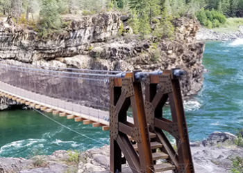
Kootenai Falls is one of the largest free flowing waterfalls in the northwest, dropping 90 feet in less than a mile. The main falls is 30 feet high and can be viewed from a “swinging bridge” that crosses the river.
Lake Koocanusa Scenic Byway
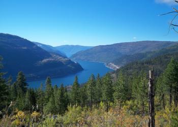
This stretch of State Highway 37 parallels Lake Koocanusa for 67 miles. The view of the lake is fantastic and there are numerous camping, picnicking, and boat access points located along the byway. Two marinas are also on the byway.
Cabinet Mountains Wilderness
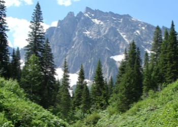
Located within the heart of the Kootenai National Forest, the Cabinet Mountains Wilderness contains over 93,000 acres of beautiful, rugged, glacier-carved mountains.
Latest Information
Kootenai National Forest Inaccessible Roads & Trails Viewer

The Kootenai National Forest Inaccessible Roads and Trails Viewer highlights the inaccessible areas across the forest due to the recent, unprecedented storm events and also illustrates the progress of road and trail clearing. The Kootenai National Forest has gathered information from forest staff as well as public and other government resources to create this dataset.
Mushroom Gathering
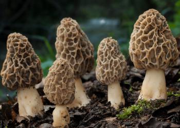
Past wildfires bring with them the possibility of bumper mushroom crops!
Find out more about harvesting mushrooms across the Northern Region national forests and grasslands and explore our mushroom hunter helper interactive map.
Huckleberry Information

Huckleberry season is now here on the Kootenai National Forest! Huckleberries are a prized wild food and a favorite treat found across the forest. While commercial gathering of huckleberries is not permitted on the Kootenai, you are welcome to gather huckleberries for personal use. Click below for more huckleberry fun facts.
Kootenai National Forest & Lincoln County Stewardship

The Kootenai National Forest and Lincoln County recently entered into a stewardship agreement to reduce wildfire risk. Read the full article to learn more about this exciting collaborative effort.