
Discover History
Human groups have occupied the mountains of western Wyoming, including the area now known as the Bridger-Teton National Forest, for the last 10,000 years. Evidence of this human presence is found in sites, artifacts, buildings, trails, and historic documents. Over 800 prehistoric and historic sites have been recorded on the Forest, yet less than 2% of the total Forest has been systematically inventoried for heritage resources. Sites have been found from the lowest river bottoms to the tops of mountain ranges. The Heritage Resource Program on the Bridger-Teton is committed to the study, protection, and interpretation of these non-renewable resources, so that present and future generations may learn about their cultural past and begin to understand the fundamental relationship between the people and the land.
Please remember: Federal Law prohibits unauthorized artifact collecting and excavating. Help preserve this non-renewable resource by taking only photographs and leaving only foot prints.
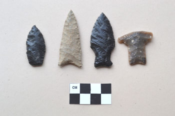
Late Paleoindian points from the Bridger-Teton
Prehistory
The prehistoric populations who called this area their home were nomadic hunters and gathers. They did not practice agriculture, nor did they establish permanent villages or settlements. Instead, they moved through the valleys and mountains on a seasonal basis to take advantage of the abundant plant and animal resources in the area. Spring time might find these groups at lower elevations where plants were beginning to bloom and fish were spawning in the rivers and creeks. With the onset of summer and the melting of snow from the foothills and mountains, these groups would follow the migration of big game animals and maturing plant species to progressively higher elevations. By late summer and early fall these groups would locate themselves in the high mountain forests and meadows, only to return to the lower elevations with the approaching winter snows.
This portion of the Rocky Mountains is adjacent to the Great Plains to the east, the Great Basin to the west and southwest, and the Columbia Plateau to the northwest. It is likely that the people who lived in this area had contact with other cultural groups through migrations to adjacent areas, which helped shape the culture of these people who called the mountains of western Wyoming their territory.
History and Culture

"Green River Rendezvous," painted by William Henry Jackson. Rendezvous provided an opportunity for trappers to gather and trade news, stories, pelts, and supplies. The closest rendezvous to Jackson Hole was Pierre's Hole, west of the Teton Range. Jackson Hole Historical Society & Museum
Most historians point to John Colter as the first of the mountain men to traverse in what is now known as the Bridger-Teton National Forest. After traveling to the Pacific Northwest with the Lewis and Clark Expedition, Colter left the expedition before returning to St. Louis. It is believed that he headed back west during the winter of 1807-1808, and crossed the Continental Divide at either Union Pass or Togwotee Pass before descending into Jackson Hole. From there he may have crossed Teton Pass into Pierre’s Hole; then re-crossed the Teton Mountain Range at Conant Pass before heading into Yellowstone.
Others were soon to follow. In 1811, John Jacob Astor, owner of the American Fur Company, traveled through the region on his way to the Oregon coast to establish a trading post in the Pacific Northwest. Wilson Price Hunt led this expedition with more than 60 men and 82 horses laden with trade goods. Instead of taking the well-known Indian Trail over Togwotee Pass into Jackson Hole, the expedition went southwest to Union Pass and crossed the Wind River Range. The expedition then descended to the headwaters of the Green River and followed the Indian Trail through Hoback Canyon to Jackson Hole and Teton Pass. In 1812, the Astor party traveled through the Gros Ventre mountain range on their way back east. Other trappers were soon to follow including Jedediah Smith, Donald McKenzie, Thomas Fitzpatrick, and Osborne Russel. The streams and rivers in northwest Wyoming became well known as prime beaver trapping country, and over the next 20 years, fur trapping became an intense and lucrative business. By 1840, demand for beaver pelts declined, and coupled with the decimation of the beaver population, the trapping industry of the early mountain men came to an end. Many of the place names in the region came from the early trappers and mountain men who frequented the area. The Bridger-Teton National Forest is named for the famous trapper and guide Jim Bridger. Jackson Hole is named after another early trapper, Davey Jackson. The Hoback River, Fontenelle and LaBarge Creeks, Smiths Fork, Hams Fork, and Greys River were all named after early trappers.

Furs had been a valuable commodity in Europe for centuries. In the eighteenth and nineteenth centuries, beaver pelts became particularly popular, and mountain men in America trapped the beaver to near extinction. Jackson Hole Historical Society & Museum
For the next 30 years, the mountains and valleys of northwest Wyoming became the center of attention for a number of government explorations, but it wasn't until the 1870s that the hunter-trapper made his reappearance in the Jackson Hole area. This new trapper was of a different breed than the earlier types. He operated on an individual basis without ties to well established trapping companies. This new trapper was seen as a man who rebelled against society and the steady advance of civilization, and moved into the more remote mountain sections of northwest Wyoming. These trappers played a significant role in the settlement of the Jackson Hole area. Many of the individuals who came to Jackson Hole in the late 1800s would eventually take up permanent residence and file homestead claims. In many cases, these trappers represented the earliest settlers in the valley and would later become prominent individuals in the socioeconomic development of the valley.
Beaver Dick Leigh was perhaps the last of the original mountain men who trapped and hunted in the Jackson Hole area. He began his career trapping with the Hudson Bay Company, but later became a free trapper and guide for the hunting parties who came to the Rocky Mountains. Beaver Dick Leigh continued to work the Jackson Hole area through the 1860s and 1870s. Another of the new breed of trappers was a man by the name of Tim Hubbard who is said to have wintered on the Snake River during 1865-66.

This beaver trap, found in the Conant Pass area, is believed to have been used by Richard "Beaver Dick" Leigh. Jackson Hole Historical Society & Museum
The Doane expedition of 1876 encountered a trapper by the name of John Pierce who was spending the winter in a cabin at the southern end of Jackson Hole, south of the present town of Wilson.
Hunters and trappers continued to come into the valley and some of them built cabins returning from year to year. John Holland trapped in Jackson Hole in the early 1870s and eventually settled a few miles northeast of the present site of Jackson along Flat Creek. Holland was one of the first settlers in Jackson Hole.
In the early 1880s Albert G. Richards, at the age of 13, came to Jackson Hole to trap with another boy named Will White from Cokeville. They planned to meet John Holland in Jackson Hole, but failed to find him. The two boys camped and trapped on the Buffalo Fork River at the northern end of Jackson Hole until February when they loaded their furs for the return trip home. At Munger Mountain they found two trappers who were holed up for the winter, Jack Davis and a man named Leland. Davis and Leland agreed to guide the boys through the Snake River Canyon to the mouth of the Greys River in exchange for the remainder of the their supplies.
In 1880, Dick Turpin came to the Jackson area and built trapping cabins on almost every good stream in the Hole at one time or another. Robert Miller, who would eventually become the Forest Supervisor of the Teton National Forest, came to Jackson Hole in 1885 and joined the "trapping fraternity of bachelors already spending winters in the valley." Stephen Leek and Pierce Cunningham also came into the valley during the 1880's to trap. Stephen Leek was elected Uinta County Representative in 1907 (at that time Jackson Hole was part of Uinta County) and helped draft legislation for the protection of Wyoming's game animals. He was instrumental in drawing attention to the fact that the elk herds in Jackson were starving during the long winter months, and helped in getting the State Legislature to appropriate money to buy hay for the elk in Jackson Hole. This would ultimately lead to the development of the National Elk Refuge. Pierce Cunningham would later homestead in Jackson Hole and his homestead has since been restored as a historical monument in Grand Teton National Park.
After the creation of the Teton National Forest in 1908, one of the jobs of the early Forest Service Rangers was to check on trappers and poachers who were so common in the backcountry. One of the more notorious poachers of the early 1900's was Charlie "Beaver Tooth" Neal who homesteaded on the banks of the Buffalo River in the northern portion of Jackson Hole. "Beaver Tooth" Neal roamed throughout the Pacific Creek and Thorofare country south of Yellowstone National Park, and was well known for his ability to give the slip to Rangers who were trying to capture him for illegal poaching and trapping.
It was common practice for trappers to have a rather extensive trapping line that usually took several days to check. In these cases, the trapper would have a number of way stations along the line for overnight stays. These were generally in the form of a crude line cabin or lean-to. An interview conducted with local trapper, Jack Hodges, describes how these trappers worked the back country.
"I believe the first year that I trapped in the wilderness area was about 1947, and most of my time in the fall of the year was spent constructing cabins so that I'd have a place to pull into when I was back on these trap lines. I had a little cabin in the head of Colter Creek, one down near the mouth of Colter Creek, which was a deluxe cabin, … big enough for one person to get into and have your food: we'd dig a cellar in the corner of the cabin, down about 3, 3 1/2 feet and put vegetables and canned stuff in a sack down into and then cover it up and it was the best refrigerator and a way to keep food that I ever had... I had about, somewhere around 75 to 100 miles of trapping line out up on my area. And you have to secure those trapping permits through the Game Department and the Forest Service in order to get your permit and area and I acquired my permits to go in there and trap, and we would go from cabin to cabin, and it took just about 7 to 8 days to make my circuit around my trap line and back to where I started."
During the early 1900s, a new type of poaching activity became common in the Jackson Hole area. Members of the B.P.O. Elks Lodge considered having an elk tooth dangle from a watch chain a status symbol. This led to a market in elk teeth, and with an abundance of elk in the Jackson Hole and Yellowstone Park area, poaching elk for their teeth became a thriving industry. As a result of the poaching activity, a number of cabins were built throughout the backcountry used by the trappers and poachers.
An early Forest Ranger described these cabins:
"There was a small log cabin located on Glade Creek at the extreme north end of Jackson Hole. Here tuskers smoked elk meat, better known as jerky, and took it by pack horse to Idaho where there was a ready market for it. This cabin, like others found around the valley later, was a cleverly arranged smoke-house built in the heavy timber to conceal it. The W.C. Lawrence’s found this cabin. Tuskers cabins were often hidden under overhanging ledges and weren't easy to spot."
Although there had been game laws in Wyoming since 1869, it wasn't until 1899 that the State provided money for a State Game Warden, and for some years he and his deputies were inadequate for the task of preventing poaching. The tusk hunters who operated in the Jackson area enraged the Jackson Hole citizens in 1905-1906 so much that they organized vigilantes. In 1907, the state legislature assisted by making the killing of big game for tusks, antlers or heads a felony. Shortly thereafter, the threat of tusk hunters diminished. After that, trapping in the backcountry continued into the first half of the 1900s.

The main Oregon/Mormon Pioneer Trail was established in the 1840s and passed just south of the present-day Bridger-Teton National Forest. This trail crossed the alkaline desert with little water or feed for the livestock. A safer and easier route was needed for the pioneers crossing western Wyoming.
In 1857, Engineer Frederick W. Lander surveyed a new route across the Green River Basin and into the mountains of the Wyoming and Salt River Ranges. The Lander Cut-off was the first federally funded road project west of the Mississippi. Over 13,000 emigrants traveled the road in its first year of use. The cutoff was 250 miles total that required 19 days of travel, including breakdowns. The use of the trail declined rapidly after 1867 when the transcontinental railroad was constructed across southern Wyoming; however, the last reported covered wagon seen on the road was in 1912.

Frederick W. Lander
Much of the Forest section of this historic trail can be traced along roads and trails with trail ruts and emigrant graves still visible. A Lander Cut-off brochure is available at Forest Service offices to assist you in following the trail and learn more about it.
To learn more about the Lander Cut-off and other emigrant trails in Wyoming visit the Wyoming State Historic Preservation Office’s website at https://wyoshpo.wyo.gov/index.php/programs/national-register/wyoming-listings/view-full-list.
With the construction of the transcontinental railroad, a vast number of railroad ties were needed. Cutting timber to produce railroad ties was known as ‘tie hacking.’ The Bridger-Teton has a long history of tie hack activities from 1867 to 1952. Ties were cut on the forested mountain slopes, skidded to a river’s edge, and floated to the nearest railroad. Evidence of tie hack activity, including abandoned cabins, can still be found along the Green River, the Hams Fork River, and in the mountains west of LaBarge and Big Piney.
The history of tie hack activities on the Bridger-Teton begins in 1867 along the upper Green River. In that year, Charles Delony contracted with the Union Pacific Railroad to supply ties to the rail head in the town of Green River. During the winter of 1867, Delony constructed a cook shack, commissary, bunkhouse, and saw mill on the banks of the Green River near the present day Forest boundary. He hired 30 men to cut ties during the winter near the head quarters. These ties were skidded down to the river's edge then floated 130 miles downstream to Green River City where Delony built a boom to catch the ties. Delony continued tie hack operations in the area until 1869, at which time the railroad company had completed its construction.
Tie hack activities along the upper Green River ceased until 1895 at which time the Green River Lumber and Tie Company was created. The headquarters for this operation was below Red Hills where the current Kendall Guard Station is located, and just two miles north from where Charles Delony cut ties 30 years earlier. The Green River Lumber and Tie Company continued its operation along the Green until 1904 at which time they had completed their orders from the Union Pacific.
A number of isolated tie hack cabins can still be found throughout the Forest in the upper Green River area. Most notable are cabins located in the Klondike Hill and Red Hills area. Isolated cabins have also been found along Rock Creek and in the Twin Creek Basin southwest of Klondike Hill.
The Hams Fork area was also the scene of early tie hack operations, but also in the production of mine props for the coal mines in the Kemmerer area. The Oregon Short Line railroad was built through Kemmerer in 1881 as a means to access the rich coal mines in the area. It is not known where the ties for this line were obtained; however, the Forest Service reported, in 1914, that evidence of old tie cuttings were visible and that the Hams Fork River was used to float the ties down stream. Competition for railroad ties appears to have been keen during the early part of the 1900s.
As stated in the Timber Reconnaissance of Hams Fork:
"The Union Pacific Railroad is the tie market. Its annual consumption of ties is approximately 1,700,000 of which 1,400,000 are for renewals and 400,000 for original construction. The average price paid was 86 cents."
It is apparent from this Timber Reconnaissance that the Forest Service was trying to promote the harvest of ties from the Hams Fork area. However it is not certain how long or extensive the tie hack operations were in the Hams Fork drainage.
The Standard Timber Company was making plans to move into the Forest west of Big Piney, as early as 1915. However the Union Pacific contracted for cheaper ties from Oregon which forced the Standard Timber Company to abandon their plans. These plans were revitalized in 1917 when the price for lumber rose as a result of World War I. In 1919, the Standard Timber Company began operations in the North and South Cottonwood Creeks with an estimated yield of over 2 million hewn ties, 39 million board feet of saw lumber and 12 million linear feet of mine props.
Accordingly, a number of tie hack villages were established in the Cottonwood Creeks area, including Johnson City, located on the banks of North Cottonwood Creek. Buildings associated with the village included a commissary, cook house, living quarters, blacksmith shop, and other outbuildings. The Johnson Village no longer exists as all the buildings were either burned to the ground or removed.
In addition to the main villages, isolate cabins were constructed throughout the Forest. Many of these cabins are visible, including locations along South Cottonwood Creek, Ole Creek, and Nylander Creek. A surge dam was built along Bare Creek to hold back the spring run-off. Once enough water and ties had accumulated behind the dam, the doors were opened and the ties were flooded down stream into South Cottonwood and eventually into the Green River.
Timber operations were to continue in the Cottonwood Creeks through the 1920s and into the 1930s. Gradually the Standard Timber Company moved its operation north into the Horse Creek drainages. Villages and isolated cabins were constructed throughout the area including North and South Horse Creek, Pass Creek, Elk Creek, and Mill Creek. One large village that no longer exists was at the mouth of Mill Creek. It was occupied by over 300 families with facilities which included a commissary, school, several bunk houses, and many cabins for the families. A doctor came to the camp once or twice a month.
The LaBarge Creek drainage became the next and final area on the Forest to be tie hacked. The first entry in the area was in 1937 when the Standard Timber Company established a major tie hack village on the banks of South LaBarge Creek. At that time the old Lander Trail was the only access into the drainage and improvements were made to the road to allow entry. Although there are no longer any standing structures remaining from this village, scattered debris can still be seen that mark the location of this once thriving community.
In addition to the South LaBarge tie hack village, a number of isolated cabins were built throughout the area, most of which have been removed or destroyed. Other evidence of tie hack activity in this area is from numerous saw dust and slash piles left throughout the drainage. These piles mark the locations of portable saw mills which were used to square off the logs prior to floating them down stream to the rail head. Portable saw mills were first used in the 1920s and replaced the old system of squaring ties by hand. The tie hack activities in the LaBarge Creek drainage came to a close in 1952.
On March 30th, 1891, President Benjamin Harrison set aside the Yellowstone Park Timber Land Reserve, located along the eastern and southern boundary of Yellowstone National Park. This presidential proclamation followed a decade of debate over the fate of America’s forested areas. Many scientists of the late 1800s saw the creation of this forested reserve as an important step in stemming the advancing tide of timber harvest, overgrazing, mining and watershed destruction. The creation of this land reserve marked the beginning of the conservation effort in America and exemplified the need for effective land management. Over the next fifteen years four presidents would place more than 94 million acres of federal lands in the American West into forest reserves.
The original Yellowstone Park Timber Land Reserve encompassed approximately 1,239,040 acres. Portions of the Yellowstone Park Timber Land Reserve now lie within the boundaries of the Teton Wilderness on the Bridger-Teton National Forest.
On February 22, 1897, President Cleveland, by executive order, created the Teton Forest Reserve from 829,440 acres of public domain land. This area, which lies south of the original Yellowstone Park Timber Land Reserve, is now part of Grand Teton National Park and the Buffalo Ranger District of the Bridger-Teton National Forest.
The creation of additional Forest Reserves picked up pace after the turn of the century. In May of 1902, President Theodore Roosevelt added an additional 5 million acres to the Forest Reserve system in northwest Wyoming and southwest Montana. The newly created Yellowstone Forest Reserve was divided into four divisions; the Absaroka Division to the north of Yellowstone National Park, the Shoshone Division to the east of Yellowstone National Park, the Teton Division which extended south of Yellowstone almost to Kemmerer, and the Wind River Division which encompassed much of the Wind River Mountains.
In 1905 President Roosevelt transferred the Forest Reserve System from the General Land Office to the Department of Agriculture, and in 1907 the name Forest Reserve was changed to National Forest. In 1908 President Roosevelt abolished the Yellowstone National Forest with its separate divisions and created the Teton, Wyoming (now Bridger), Absaroka and Beartooth (now Custer), Shoshone, Bonneville (now Caribou), and Targhee National Forests. The Wyoming National Forest was renamed the Bridger National Forest in 1941. In 1973 the Bridger and Teton National Forests were combined to form a single forest. Today the Bridger-Teton National Forest consists of 3,439,809 acres of public land in northwest Wyoming.
Teton National Forest History
The Depression is considered a major turning point in American history, ushering in a new era and presidency under Franklin Delano Roosevelt. With his “New Deal” for the American people, Roosevelt implemented a number of economic relief programs with the Civilian Conservation Corps (CCC) having the most significant effect on the Bridger-Teton National Forest. During the Depression, the agency saw a drastic decrease in timber and grazing activity and returns as the markets for these products declined. Roosevelt tried to offset this with a drastic increase in funding and a large labor force provided through the CCC program.
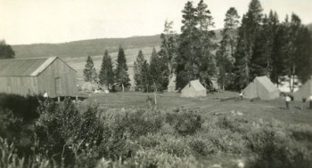
The CCC program allowed the Forest Service to construct a number of improvements and carry out a significant amount of conservation work. A number of CCC camps were established on the forest including the Dog Creek Camp in the Snake River Canyon, the Cliff Creek Camp in the Hoback River Canyon, the Fremont Camp near Pinedale, The Grover Park Camp near Afton, and the Camp at Alpine. A number of smaller “spike camps” were established throughout the forest. The primary projects completed by these CCC camps include the construction of the Granite Creek swimming pool and campground, the construction of the Wilson-Fall Creek Road and the Snake River Canyon Road, and the construction of hiking trails and campgrounds. In addition, the CCCs built a number of fire lookouts and guard stations throughout the forest which are still in use today. Many of these guard stations are available for rental under the Cabin Rental Program.

The Forest Service benefited greatly from the CCC program. The infusion of funds and a large labor force allowed for the construction of much-needed facilities and improvements to road, trails, and recreation sites. These facilities offered better access to forest resources and helped meet the recreation needs of the public in the post-WWII era.
For more information about the CCCs in Western Wyoming you can visit the Sublette County website at http://www.sublette.com/history/ccc.