
Smoke modeling tools reduce impacts to communities
Scott Raymond , Southern Region Office of Communication
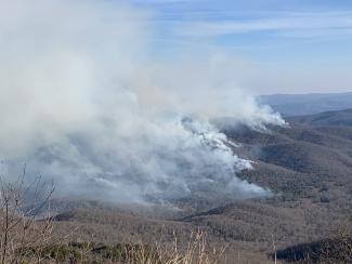
Prescribed fire is a critical land management tool that keeps our forests healthy, but sometimes results in smoke in some communities.
This fuels reduction method burns woody debris on the forest floor, such as dead branches and organic matter, which reduces the overall potential for dangerous wildfires.
Forest Service employees in the Southern Region have been conducting prescribed burns for years. More acres are treated with this method in the South than anywhere else in the country. To limit smoke’s impacts to air quality, smoke modeling is becoming increasingly more important.
Smoke modeling is the process of using computer dispersion modeling tools to estimate downwind concentrations of pollutants resulting from fires. In other words, this tool anticipates where the smoke will go and allows us to adjust our methods to achieve a desired outcome.
The study of dispersion modeling is providing extremely useful information of potential smoke impacts on nearby communities and roadways, according to Melanie Pitrolo, Air Program Manager for the Forest Service’s Southern Region.
“We want to ensure that public health is protected while also providing the resource benefits that come from prescribed fire,” said Pitrolo. “The science of what we do, both the modeling tools available as well as the latest research on health impacts, is continually evolving. That science also drives all that we do.”
The national ambient air quality standards established for certain pollutants include fine particulate matter and carbon monoxide, the two most prevalent pollutants found in smoke. How much smoke is produced from a fire depends on the types of fuels in the forest, the weather and the slope of the ground. The information provided from smoke modeling and how these pollutants increase in the air, are used to help guide decisions on prescribed burning. The goal is to ensure minimal impacts to air quality for local citizens as well as for firefighters.
“We utilize advanced smoke and fire behavior modeling before every prescribed burn to predict how much smoke will be produced, for how long, where it will go and how fast it will disperse,” said Mike Ward, Prescribed Fire & Fuels Program Manager for the Southern Region. “Prescribed burning or planned ignitions, reduce potential smoke impacts to public health and safety because it focuses the use of science and established wildland fire management techniques to effectively and safely apply fire to the landscape.”
In 2021, the Southern Region implemented more than 2,000 hazardous fuels reduction treatments on 1.2 million acres of forest and grasslands across 13 states. Prescribed burns are planned and implemented under very specific parameters or combinations of weather, drought, and atmospheric conditions to achieve desired fire intensities and smoke emissions concentrations.
“A little smoke now from a controlled burn is much better than a lot of smoke from a significant wildfire later,” added Ward.
In a recent study of a prescribed burn in the Funnel Top area of the Pisgah National Forest in North Carolina, the science and the actions taken aligned to validate the smoke modeling process. Pitrolo said five smoke monitors were strategically placed to capture pollutant levels from the burn. The results were provided to the forest as a complete study of downwind daytime impacts for prescribed fire. Even with an unpredicted wind shift, the monitoring values indicated that air pollution concentrations did not reach a level of concern from a public health standpoint as a result of this burn, which confirmed what the smoke dispersion modeling showed.
Air quality experts with the USDA Forest Service and partner agencies assisted the forest with the burn to ensure the best smoke dispersion and minimize air quality impacts near local communities.
“The Funnel Top study is an example of how we are increasing our knowledge of air quality impacts from prescribed burns,” said Pitrolo. “The results demonstrate we are focused on assisting forests with their land management objectives while also limiting the negative impacts on the general public.”
Forest Service employees, alongside environmental experts and partner agencies, continue to study and learn from the smoke from intentional burns and unintentional wildfires across the country.
The Southern Region of the USDA Forest Service is comprised of 13 states and Puerto Rico. The region consists of 14 national forest units and two special units. National Forests in the Southern Region are managed to strike a balance between resource development and protecting wild places for recreation and wildlife.