


| Collection: | RMRS Archive Images |
| Keywords: |
snow mixed conifer watershed research watershed management |
| Location: | ThomasCreek Experimental Watershed, Apache-Sitgraves NF; AZ; USA |
| Description: | Boris is show-shoeing up the ridge between the North and South Forks of Thomas Creek. |
| Date: | 01/23/2004 |

| Collection: | RMRS Archive Images |
| Keywords: |
snow mixed conifer scenic watershed research watershed management |
| Location: | Thomas Creek Experimental Watershed, Apache-Sitgraves NF; AZ; USA |
| Description: | The ridge bewteen North and South Forks of Thomas Creek. |
| Date: | 01/23/2004 |

| Collection: | RMRS Archive Images |
| Keywords: |
snow watershed research watershed management |
| Location: | Thomas Creek Experimental Watershed, Apache-Sitgraves NF; AZ; USA |
| Description: | Duncan is taking a breather in the sun, while GPSing the watershed boundaries of Thomas Creek. |
| Date: | 01/23/2004 |

| Collection: | RMRS Archive Images |
| Keywords: |
snow mixed conifer watershed research watershed management |
| Location: | Thomas Creek Experimental Watershed, Apache-Sitgraves NF; AZ; USA |
| Description: | Boris and Duncan are dicussing the watershed boundaries of Thomas Creek. |
| Date: | 01/23/2004 |

| Collection: | RMRS Archive Images |
| Keywords: |
snow watershed research watershed management |
| Location: | Thomas Creek Experimental Watershed, Apache-Sitgraves NF; AZ; USA |
| Description: | Lost? We are never lost. We have a GPS. |
| Date: | 01/23/2004 |

| Collection: | RMRS Archive Images |
| Keywords: |
mixed conifer watershed research watershed management |
| Location: | Thomas Creek Experimental Watershed, White Mountain Apache-Sitgraves NF; AZ; USA |
| Description: | The watershed boundaries of the Thomas Creek experimental watersheds follow pronounced ridges to the North-East. |
| Date: | 01/08/2004 |

| Collection: | RMRS Archive Images |
| Keywords: |
snow mixed conifer watershed research watershed management |
| Location: | Thomas Creek Experimental Watershed, White Mountain Apache-Sitgraves NF; AZ; USA |
| Description: | The watershed boundaries of the Thomas Creek experimental watersheds are marked with white paint. |
| Date: | 01/08/2004 |

| Collection: | RMRS Archive Images |
| Keywords: |
mixed conifer scenic snag watershed management |
| Location: | Thomas Creek Experimental Watershed, White Mountain Apache-Sitgraves NF; AZ; USA |
| Description: | A burned snag just south of the Thomas Creek experimental watershed. |
| Date: | 01/08/2004 |

| Collection: | RMRS Archive Images |
| Keywords: |
snow watershed research watershed management |
| Location: | Thomas Creek Experimental Watershed, White Mountain Apache-Sitgraves NF; AZ; USA |
| Description: | Boris is using a hand held GPS to record the watershed boundary of Thomas Creek South Fork. |
| Date: | 01/08/2004 |

| Collection: | RMRS Archive Images |
| Keywords: |
snow mixed conifer snag watershed research watershed management |
| Location: | Thomas Creek Experimental Watershed, White Mountain Apache-Sitgraves NF; AZ; USA |
| Description: | Steep slopes and downed logs make up the majority of the Thomas Creek South Fork watershed. |
| Date: | 01/08/2004 |

| Collection: | RMRS Archive Images |
| Keywords: |
stream gage watershed structures watershed research watershed management |
| Location: | Thomas Creek Experimental Watershed, White Mountain Apache-Sitgraves NF; AZ; USA |
| Description: | Gauging Station of Thomas Creek North Fork |
| Date: | 01/07/2004 |

| Collection: | RMRS Archive Images |
| Keywords: |
watershed structures watershed research watershed management |
| Location: | Thomas Creek Experimental Watershed, White Mountain Apache-Sitgraves NF; AZ; USA |
| Description: | Gauging Station of Thomas Creek North Fork |
| Date: | 01/07/2004 |

| Collection: | RMRS Archive Images |
| Keywords: |
snow wildlife watershed management |
| Location: | Thomas Creek Experimental Watershed, White Mountain Apache-Sitgraves NF; AZ; USA |
| Description: | Wildlife tracks in the snow close to the Thomas Creek weir no. 2. |
| Date: | 01/07/2004 |

| Collection: | RMRS Archive Images |
| Keywords: |
watershed research watershed management |
| Location: | Thomas Creek Experimental Watershed, White Mountain Apache-Sitgraves NF; AZ; USA |
| Description: | Steve is using a 5 ft topographical map to determine the watershed boundary |
| Date: | 01/07/2004 |

| Collection: | RMRS Archive Images |
| Keywords: |
watershed research watershed management |
| Location: | Thomas Creek Experimental Watershed, White Mountain Apache-Sitgraves NF; AZ; USA |
| Description: | Boris is using a hand held GPS to record the watershed boundary of Thomas Creek South Fork. |
| Date: | 01/07/2004 |

| Collection: | RMRS Archive Images |
| Keywords: |
mixed conifer scenic watershed research watershed management |
| Location: | Thomas Creek Experimental Watershed, White Mountain Apache-Sitgraves NF; AZ; USA |
| Description: | Mixed conifer vegetation inThomas Creek North Fork watershed. |
| Date: | 01/07/2004 |

| Collection: | RMRS Archive Images |
| Keywords: |
mixed conifer watershed research watershed management |
| Location: | Thomas Creek Experimental Watershed, White Mountain Apache-Sitgraves NF; AZ; USA |
| Description: | The watershed boundaries of the Thomas Creek experimental watersheds are marked with white paint. |
| Date: | 01/07/2004 |

| Collection: | RMRS Archive Images |
| Keywords: |
mixed conifer wildlife watershed research watershed management |
| Location: | Thomas Creek Experimental Watershed, White Mountain Apache-Sitgraves NF; AZ; USA |
| Description: | A rabbit is hidding under a conifer at the Thomas Creek experimental watershed in the early evening hours |
| Date: | 01/07/2004 |

| Collection: | RMRS Archive Images |
| Keywords: |
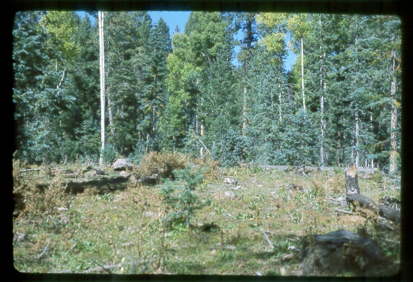
vegetation treatment mixed conifer watershed management |
| Location: | Thomas Creek; AZ; United States |
| Description: | Not Available |
| Date: | 10/1982 |
| Collection: | RMRS Archive Images |
| Keywords: |
vegetation treatment mixed conifer watershed management |
| Location: | Thomas Creek; AZ; United States |
| Description: | Not Available |
| Date: | 10/1982 |

| Collection: | RMRS Archive Images |
| Keywords: |
stream gage mixed conifer watershed management |
| Location: | Thomas Creek; AZ; United States |
| Description: | weir |
| Date: | 7/1976 |

| Collection: | RMRS Archive Images |
| Keywords: |
mixed conifer watershed management |
| Location: | Thomas Creek; AZ; United States |
| Description: | Not Available |
| Date: | 3/1976 |
| Collection: | RMRS Archive Images |
| Keywords: |
figure watershed management |
| Location: | Thomas Creek; AZ; United States |
| Description: | Not Available |
| Date: | 2/1976 |

| Collection: | RMRS Archive Images |
| Keywords: |
figure watershed management |
| Location: | Thomas Creek; AZ; United States |
| Description: | Not Available |
| Date: | 2/1976 |

| Collection: | RMRS Archive Images |
| Keywords: |
figure watershed management |
| Location: | Thomas Creek; AZ; United States |
| Description: | Not Available |
| Date: | 1/1976 |

| Collection: | RMRS Archive Images |
| Keywords: |
figure watershed management |
| Location: | Thomas Creek; AZ; United States |
| Description: | Thomas Creek |
| Date: | 1/1976 |

| Collection: | RMRS Archive Images |
| Keywords: |
figure watershed management |
| Location: | Thomas Creek; AZ; United States |
| Description: | Not Available |
| Date: | 1976 |

| Collection: | RMRS Archive Images |
| Keywords: |
figure watershed management |
| Location: | Thomas Creek; AZ; United States |
| Description: | Not Available |
| Date: | 1976 |

| Collection: | RMRS Archive Images |
| Keywords: |
map figure watershed management |
| Location: | Thomas Creek; AZ; United States |
| Description: | Not Available |
| Date: | 1976 |

| Collection: | RMRS Archive Images |
| Keywords: |
map figure watershed management |
| Location: | Thomas Creek; AZ; United States |
| Description: | North fork conversion-80 acres of 248 acre watershed. |
| Date: | 1976 |

| Collection: | RMRS Archive Images |
| Keywords: |
mixed conifer watershed management |
| Location: | Thomas Creek; AZ; United States |
| Description: | Not Available |
| Date: | 1976 |

| Collection: | RMRS Archive Images |
| Keywords: |
mixed conifer watershed management |
| Location: | Thomas Creek; AZ; United States |
| Description: | Not Available |
| Date: | 1976 |

| Collection: | RMRS Archive Images |
| Keywords: |
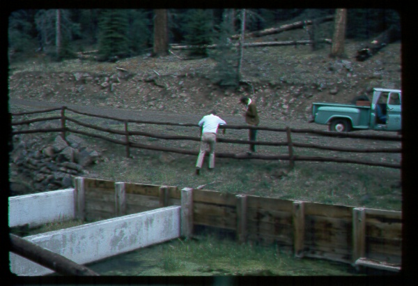
stream gage mixed conifer watershed management |
| Location: | Thomas Creek; AZ; United States |
| Description: | weir |
| Date: | 12/1974 |

| Collection: | RMRS Archive Images |
| Keywords: |
stream gage mixed conifer watershed management |
| Location: | Thomas Creek; AZ; United States |
| Description: | White Mountains, weir |
| Date: | 12/1974 |

| Collection: | RMRS Archive Images |
| Keywords: |
mixed conifer watershed management |
| Location: | Thomas Creek; AZ; United States |
| Description: | White Mountains |
| Date: | 12/1974 |

| Collection: | RMRS Archive Images |
| Keywords: |
stream gage mixed conifer watershed management |
| Location: | Thomas Creek; AZ; United States |
| Description: | White Mountains, weir |
| Date: | 12/1974 |

| Collection: | RMRS Archive Images |
| Keywords: |
stream gage mixed conifer watershed management |
| Location: | Thomas Creek; AZ; United States |
| Description: | White Mountains, weir |
| Date: | 11/1974 |
| Collection: | RMRS Archive Images |
| Keywords: |
mixed conifer watershed management |
| Location: | Thomas Creek; AZ; United States |
| Description: | White Mountains, weir |
| Date: | 11/1974 |

| Collection: | RMRS Archive Images |
| Keywords: |
personnel watershed management |
| Location: | Thomas Creek; AZ; United States |
| Description: | Thomas Creek, Apache Sitgreaves N.F. |
| Date: | 11/1974 |

| Collection: | RMRS Archive Images |
| Keywords: |
mixed conifer watershed management |
| Location: | Thomas Creek; AZ |
| Description: | Not Available |
| Date: | 10/1973 |

| Collection: | RMRS Archive Images |
| Keywords: |
mixed conifer watershed management |
| Location: | Thomas Creek; AZ; United States |
| Description: | Not Available |
| Date: | 10/1973 |

| Collection: | RMRS Archive Images |
| Keywords: | watershed management |
| Location: | Thomas Creek; AZ; United States |
| Description: | Thomas Ck North Fork, snow survey |
| Date: | 3/1973 |

| Collection: | RMRS Archive Images |
| Keywords: |
personnel research techniques watershed management |
| Location: | Thomas Creek; AZ; United States |
| Description: | snow survey |
| Date: | 3/1973 |

| Collection: | RMRS Archive Images |
| Keywords: |
snow mixed conifer watershed management |
| Location: | Thomas Creek; AZ; United States |
| Description: | Not Available |
| Date: | 12/1972 |

| Collection: | RMRS Archive Images |
| Keywords: |
stream gage mixed conifer watershed management |
| Location: | Thomas Creek; AZ; United States |
| Description: | weir |
| Date: | 1968 |

| Collection: | Fort Valley Experimental Forest historical photographs |
| Keywords: |
forest stand watershed |
| Location: | Thomas Creek; AZ; USA |
| Description: | North Fork Thomas Creek |
| Date: | 10/1965 |

| Collection: | RMRS Archive Images |
| Keywords: | watershed management |
| Location: | Thomas Creek; AZ; United States |
| Description: | Snow Lysimeter and radiation monitor |
| Date: |

| Collection: | RMRS Archive Images |
| Keywords: |
wildlife birds wildlife ecology and conservation |
| Location: | Thomas Creek; AZ |
| Description: | Acorn woodpecker tree |
| Date: |

| Collection: | RMRS Archive Images |
| Keywords: |
wildlife birds wildlife ecology and conservation |
| Location: | Thomas Creek; AZ |
| Description: | Acorn woodpecker tree |
| Date: |