| Collection: | Southern Research Station Historical Documents and Images |
| Keywords: | roadbank |
| Location: | Mena Ranger District, Polk County, Arkansas |
| Description: | Caption reads: "Plot no. 18, 2 to 1 slope, shady cooperative roadbank study." Study/demonstration area on the Ouachita National Forest, with sign by Southern Forest Experiment Station, part of their soil stabilization along roadbanks. |
| Date: | 12/19/1940 |
| Collection: | Southern Research Station Historical Documents and Images |
| Keywords: | runoff |
| Location: | East Nesbitt Creek, Irons Fork Experimental Forest, Arkansas |
| Description: | Caption reads: "Hoover-Nesbitt runoff plots 45&46. View of surface runoff plots 45&46 taken from ladder tripod below plots. Plots are located on lower contour trail in East Nesbitt Creek. Covertype--trees." |
| Date: | 11/18/1940 |
| Collection: | Southern Research Station Historical Documents and Images |
| Keywords: | runoff |
| Location: | East Nesbitt Creek, Irons Fork Experimental Forest, Arkansas |
| Description: | Caption reads: "Hoover-Nesbitt runoff plots 41&42. View of surface runoff plots 41&42 taken from ladder tripod below plots. Plots are located on lower contour trail in East Nesbitt Creek. Covertype--trees&reproduction." |
| Date: | 11/15/1940 |
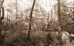
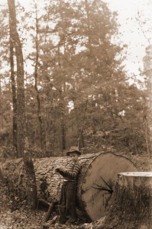
| Collection: | Southern Research Station Historical Documents and Images |
| Keywords: |
experimental forest big tree personnel |
| Organisms: | white oak |
| Location: | Crossett Experimental Forest; Ashley County; Arkansas |
| Description: | Caption reads: "Fine example of high grade forked leaf white oak (Quercus alba) cut for sawlogs. First log scaled 817 feet (12 ft.) Doyle Scale and entire tree contained 2750 feet." Boy is one of Russ Reynolds' sons. |
| Date: | 11/4/1940 |
| Collection: | Southern Research Station Historical Documents and Images |
| Keywords: | fertilizer |
| Location: | Mena Ranger District, Polk County, Arkansas |
| Description: | Caption reads: "Plot no. 5, TVA fertilizer study, Rich Mountain T.T. [Truck Trail?]. Bermuda sod with brush removed." Part of Southern Forest Experiment Station's soil stabilization along roadbank study. |
| Date: | 11/1/1940 |
| Collection: | Southern Research Station Historical Documents and Images |
| Keywords: | runoff |
| Location: | East Nesbitt Creek, Irons Fork Experimental Forest, Arkansas |
| Description: | Caption reads: "Hoover-Nesbitt runoff plots 47&48. View of surface runoff plots 47&48 taken from ladder tripod below plots. Plots are located on lower contour trail in East Nesbitt Creek. Covertype--reproduction (pine-hardwood)." |
| Date: | 10/28/1940 |
| Collection: | Southern Research Station Historical Documents and Images |
| Keywords: | runoff |
| Location: | West Hoover Creek, Irons Fork Experimental Forest, Arkansas |
| Description: | Caption reads: "Hoover-Nesbitt runoff plots 49&50. View of surface runoff plots 49&50 taken from ladder tripod below plots. Plots are located on lower contour trail in West Hoover Creek. Covertype--trees & reproduction." |
| Date: | 10/28/1940 |
| Collection: | Southern Research Station Historical Documents and Images |
| Keywords: | runoff |
| Location: | West Hoover Creek, Irons Fork Experimental Forest, Arkansas |
| Description: | Caption reads: "Hoover-Nesbitt runoff plots 51&52. View of surface runoff plots 51&52 taken from ladder tripod below plots. Plots are located on lower contour trail in West Hoover Creek. Covertype--trees." |
| Date: | 10/28/1940 |
| Collection: | Southern Research Station Historical Documents and Images |
| Keywords: | runoff |
| Location: | West Hoover Creek, Irons Fork Experimental Forest, Arkansas |
| Description: | Caption reads: "Hoover-Nesbitt runoff plots 53&54. View of surface runoff plots 53&54 taken from ladder tripod below plots. Plots are located on lower contour trail in West Hoover Creek. Covertype--reproduction." |
| Date: | 10/28/1940 |
| Collection: | Southern Research Station Historical Documents and Images |
| Keywords: | runoff |
| Location: | West Hoover Creek, Irons Fork Experimental Forest, Arkansas |
| Description: | Caption reads: "Hoover-Nesbitt runoff plots 55&56. View of surface runoff plots 55&56 taken from ladder tripod below plots. Plots are located on lower contour trail in West Hoover Creek. Covertype--open." |
| Date: | 10/28/1940 |
| Collection: | Southern Research Station Historical Documents and Images |
| Keywords: | runoff |
| Location: | East Hoover Creek, Irons Fork Experimental Forest, Arkansas |
| Description: | Caption reads: "Hoover-Nesbitt runoff plots 57&58. View of surface runoff plots 57&58 taken from ladder tripod below plots. Plots are located on lower contour trail in East Hoover Creek. Covertype--trees&reproduction." |
| Date: | 10/28/1940 |
| Collection: | Southern Research Station Historical Documents and Images |
| Keywords: | runoff |
| Location: | East Hoover Creek, Irons Fork Experimental Forest, Arkansas |
| Description: | Caption reads: "Hoover-Nesbitt runoff plots 59&60. View of surface runoff plots 59&60 taken from ladder tripod below plots. Plots are located on lower contour trail in East Hoover Creek. Covertype--trees." |
| Date: | 10/28/1940 |
| Collection: | Southern Research Station Historical Documents and Images |
| Keywords: | runoff |
| Location: | East Hoover Creek, Irons Fork Experimental Forest, Arkansas |
| Description: | Caption reads: "Hoover-Nesbitt runoff plots 61&62. View of surface runoff plots 61&62 taken from ladder tripod below plots. Plots are located on lower contour trail in East Hoover Creek. Covertype--reproduction." |
| Date: | 10/28/1940 |
| Collection: | Southern Research Station Historical Documents and Images |
| Keywords: | runoff |
| Location: | East Hoover Creek, Irons Fork Experimental Forest, Arkansas |
| Description: | Caption reads: "Hoover-Nesbitt runoff plots 63&64. View of surface runoff plots 63&64 taken from ladder tripod below plots. Plots are located on lower contour trail in East Hoover Creek. Covertype--open." |
| Date: | 10/28/1940 |
| Collection: | Southern Research Station Historical Documents and Images |
| Keywords: | runoff |
| Location: | West Hoover Creek, Irons Fork Experimental Forest, Arkansas |
| Description: | Caption reads: "Hoover-Nesbitt runoff plots 19&20. View of surface runoff plots 19&20 taken from ladder tripod below plots. Plots are located on upper contour trail in West Hoover Creek. Covertype--trees&reproduction." |
| Date: | 10/23/1940 |
| Collection: | Southern Research Station Historical Documents and Images |
| Keywords: | runoff |
| Location: | West Hoover Creek, Irons Fork Experimental Forest, Arkansas |
| Description: | Caption reads: "Hoover-Nesbitt runoff plots 21&22. View of surface runoff plots 21&22 taken from ladder tripod below plots. Plots are located on upper contour trail in West Hoover Creek. Covertype--open." |
| Date: | 10/23/1940 |
| Collection: | Southern Research Station Historical Documents and Images |
| Keywords: | runoff |
| Location: | West Hoover Creek, Irons Fork Experimental Forest, Arkansas |
| Description: | Caption reads: "Hoover-Nesbitt runoff plots 23&24. View of surface runoff plots 23&24 taken from ladder tripod below plots. Plots are located on upper contour trail in West Hoover Creek. Covertype--reproduction." |
| Date: | 10/23/1940 |
| Collection: | Southern Research Station Historical Documents and Images |
| Keywords: | runoff |
| Location: | East Hoover Creek, Irons Fork Experimental Forest, Arkansas |
| Description: | Caption reads: "Hoover-Nesbitt runoff plots 25&26. View of surface runoff plots 25&26 taken from ladder tripod below plots. Plots are located on upper contour trail in East Hoover Creek. Covertype--reproduction." |
| Date: | 10/23/1940 |
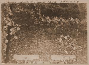
| Collection: | Southern Research Station Historical Documents and Images |
| Keywords: | runoff |
| Location: | East Hoover Creek, Irons Fork Experimental Forest, Arkansas |
| Description: | Caption reads: "Hoover-Nesbitt runoff plots 27&28. View of surface runoff plots 27&28 taken from ladder tripod below plots. Plots are located on upper contour trail in East Hoover Creek. Covertype--trees&reproduction." |
| Date: | 10/23/1940 |


![Caption reads: "Plot no. 5, TVA fertilizer study, Rich Mountain T.T. [Truck Trail?]. Bermuda sod with brush removed." Part of Southern Forest Experiment Station's soil stabilization along roadbank study. Caption reads: "Plot no. 5, TVA fertilizer study, Rich Mountain T.T. [Truck Trail?]. Bermuda sod with brush removed." Part of Southern Forest Experiment Station's soil stabilization along roadbank study.](/rds/imagedb/images/_thm/28803.jpg)


