


| Collection: | RMRS Archive Images |
| Keywords: |
map wildfire signage |
| Location: | Fort Apache Indian Reservation/Apache-Sitgraves National Forest; AZ; USA |
| Description: | Information is conveyed as best as possible. |
| Date: | 06/30/2002 |

| Collection: | RMRS Archive Images |
| Keywords: |
map wildfire |
| Location: | Apache-Sitgraves National Forest; AZ; USA |
| Description: | Information is conveyed as best as possible. |
| Date: | 06/27/2002 |

| Collection: | RMRS Archive Images |
| Keywords: |
map wildfire |
| Location: | Apache-Sitgraves National Forest; AZ; USA |
| Description: | Keeping track as the fire advances. |
| Date: | 06/27/2002 |

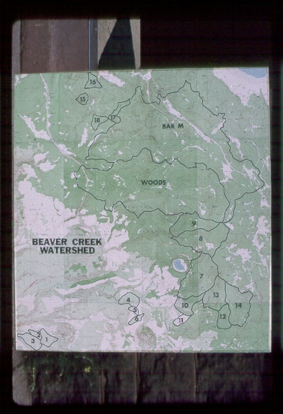
| Collection: | RMRS Archive Images |
| Keywords: |
map watershed management |
| Location: | Beaver Creek; AZ; United States |
| Description: | Not Available |
| Date: | 1989 |

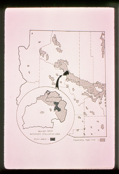
| Collection: | RMRS Archive Images |
| Keywords: |
map watershed management |
| Location: | Beaver Creek; AZ; United States |
| Description: | Pilot watersheds |
| Date: | 4/1976 |

| Collection: | RMRS Archive Images |
| Keywords: |
map watershed management |
| Location: | Beaver Creek; AZ; United States |
| Description: | WS 19, Woods Canyon |
| Date: | 4/1976 |

| Collection: | RMRS Archive Images |
| Keywords: |
map watershed management |
| Location: | Beaver Creek; AZ; United States |
| Description: | Not Available |
| Date: | 1/1976 |

| Collection: | RMRS Archive Images |
| Keywords: |
map figure watershed management |
| Location: | Thomas Creek; AZ; United States |
| Description: | Not Available |
| Date: | 1976 |

| Collection: | RMRS Archive Images |
| Keywords: |
map watershed management |
| Location: | Willow Creek; AZ; United States |
| Description: | Willow and Thomas watersheds. |
| Date: | 1976 |

| Collection: | RMRS Archive Images |
| Keywords: |
map figure watershed management |
| Location: | Thomas Creek; AZ; United States |
| Description: | North fork conversion-80 acres of 248 acre watershed. |
| Date: | 1976 |

| Collection: | RMRS Archive Images |
| Keywords: |
map watershed management |
| Location: | Beaver Creek; AZ; United States |
| Description: | WS 19 |
| Date: | 1976 |

| Collection: | RMRS Archive Images |
| Keywords: |
map watershed management |
| Location: | Beaver Creek; AZ |
| Description: | WS 19, WS 20 |
| Date: | 1976 |

| Collection: | RMRS Archive Images |
| Keywords: |
map watershed management |
| Location: | AZ; United States |
| Description: | Not Available |
| Date: | 4/1975 |

| Collection: | RMRS Archive Images |
| Keywords: |
map watershed management |
| Location: | AZ; United States |
| Description: | Not Available |
| Date: | 4/1975 |

| Collection: | RMRS Archive Images |
| Keywords: |
map watershed management |
| Location: | AZ; United States |
| Description: | Not Available |
| Date: | 4/1975 |

| Collection: | RMRS Archive Images |
| Keywords: |
map watershed management |
| Location: | AZ; United States |
| Description: | Not Available |
| Date: | 4/1975 |

| Collection: | RMRS Archive Images |
| Keywords: |
map watershed management |
| Location: | AZ; United States |
| Description: | Not Available |
| Date: | 4/1975 |
| Collection: | RMRS Archive Images |
| Keywords: |
map watershed management |
| Location: | Beaver Creek; AZ; United States |
| Description: | WS 19, WS 20 |
| Date: | 1975 |

| Collection: | RMRS Archive Images |
| Keywords: |
map watershed management |
| Location: | Beaver Creek; AZ; United States |
| Description: | WS 19, Woods Canyon |
| Date: | 1975 |

| Collection: | RMRS Archive Images |
| Keywords: |
map watershed management |
| Location: | Beaver Creek; AZ; United States |
| Description: | WS 19, Wood Canyon |
| Date: | 1975 |

| Collection: | RMRS Archive Images |
| Keywords: |
map watershed management |
| Location: | Beaver Creek; AZ; United States |
| Description: | Locations of Subwatersheds on Beaver Creek, Arizona |
| Date: | 1975 |

| Collection: | RMRS Archive Images |
| Keywords: |
map watershed management |
| Location: | Beaver Creek; AZ; United States |
| Description: | Not Available |
| Date: | 1975 |

| Collection: | RMRS Archive Images |
| Keywords: |
map watershed management |
| Location: | Beaver Creek; AZ; United States |
| Description: | Not Available |
| Date: | 1975 |

| Collection: | RMRS Archive Images |
| Keywords: |
map watershed management |
| Location: | Beaver Creek; AZ; United States |
| Description: | Not Available |
| Date: | 1975 |

| Collection: | RMRS Archive Images |
| Keywords: |
map watershed management |
| Location: | Beaver Creek; AZ; United States |
| Description: | Not Available |
| Date: | 1975 |

| Collection: | RMRS Archive Images |
| Keywords: |
map watershed management |
| Location: | Beaver Creek; AZ; United States |
| Description: | Not Available |
| Date: | 1975 |

| Collection: | RMRS Archive Images |
| Keywords: |
map watershed management |
| Location: | AZ; United States |
| Description: | Not Available |
| Date: | 1975 |

| Collection: | RMRS Archive Images |
| Keywords: |
map watershed management |
| Location: | AZ, NM; United States |
| Description: | Not Available |
| Date: | 7/1974 |
| Collection: | RMRS Archive Images |
| Keywords: |
map watershed management |
| Location: | Beaver Creek; AZ; United States |
| Description: | Not Available |
| Date: | 6/1974 |

| Collection: | RMRS Archive Images |
| Keywords: |
map watershed management |
| Location: | AZ; United States |
| Description: | Not Available |
| Date: | 6/1974 |

| Collection: | RMRS Archive Images |
| Keywords: |
map watershed management |
| Location: | AZ; United States |
| Description: | Not Available |
| Date: | 6/1974 |

| Collection: | RMRS Archive Images |
| Keywords: |
map watershed management |
| Location: | Beaver Creek; AZ; United States |
| Description: | Ponderosa Pine Type on the Salt-Verde Watershed |
| Date: | 1974 |

| Collection: | RMRS Archive Images |
| Keywords: |
map watershed management |
| Location: | Beaver Creek; AZ; United States |
| Description: | Not Available |
| Date: | 1974 |

| Collection: | RMRS Archive Images |
| Keywords: |
map watershed management |
| Location: | Beaver Creek; AZ; United States |
| Description: | Not Available |
| Date: | 1974 |

| Collection: | RMRS Archive Images |
| Keywords: |
map watershed management |
| Location: | Beaver Creek; AZ; United States |
| Description: | Not Available |
| Date: | 1974 |

| Collection: | RMRS Archive Images |
| Keywords: |
map watershed management |
| Organisms: | ponderosa pine |
| Location: | AZ; United States |
| Description: | Not Available |
| Date: | 1974 |

| Collection: | RMRS Archive Images |
| Keywords: |
map watershed management |
| Organisms: | pinyon-juniper |
| Location: | AZ; United States |
| Description: | Not Available |
| Date: | 1974 |

| Collection: | RMRS Archive Images |
| Keywords: |
map watershed management |
| Location: | Beaver Creek; AZ; United States |
| Description: | Not Available |
| Date: | 1974 |

| Collection: | RMRS Archive Images |
| Keywords: |
map watershed management |
| Location: | White Mountains; AZ; United States |
| Description: | Thomas Creek watersheds., Apache- Sitgreaves N.F. |
| Date: | 9/1973 |

| Collection: | RMRS Archive Images |
| Keywords: |
map watershed management |
| Location: | Beaver Creek; AZ; United States |
| Description: | Not Available |
| Date: | 2/1973 |

| Collection: | RMRS Archive Images |
| Keywords: |
map watershed management |
| Location: | Beaver Creek; AZ; United States |
| Description: | WS 17 |
| Date: | 1973 |

| Collection: | RMRS Archive Images |
| Keywords: |
map watershed management |
| Location: | AZ; United States |
| Description: | High water yield areas in AZ |
| Date: | 1970 |

| Collection: | RMRS Archive Images |
| Keywords: |
map watershed management |
| Location: | Beaver Creek; AZ; United States |
| Description: | Salt-Verde River Basin |
| Date: | 1970 |

| Collection: | RMRS Archive Images |
| Keywords: |
map watershed management |
| Location: | Beaver Creek; AZ; United States |
| Description: | Pilot Watersheds on Beaver Creek, Arizona |
| Date: | 1970 |

| Collection: | RMRS Archive Images |
| Keywords: |
map watershed management |
| Location: | Beaver Creek; AZ; United States |
| Description: | Not Available |
| Date: | 1970 |

| Collection: | RMRS Archive Images |
| Keywords: |
map watershed management |
| Location: | Beaver Creek; AZ; United States |
| Description: | Not Available |
| Date: | 1970 |

| Collection: | RMRS Archive Images |
| Keywords: |
map watershed management |
| Location: | Beaver Creek; AZ; United States |
| Description: | Vegetation Types on Woods Canyon, Arizona |
| Date: | 1970 |

| Collection: | RMRS Archive Images |
| Keywords: |
map watershed management |
| Location: | Beaver Creek; AZ; United States |
| Description: | Not Available |
| Date: | 1970 |

| Collection: | RMRS Archive Images |
| Keywords: |
map watershed management |
| Location: | Beaver Creek; AZ; United States |
| Description: | Not Available |
| Date: | 1970 |

| Collection: | RMRS Archive Images |
| Keywords: |
map watershed management |
| Location: | White Mountains; AZ; United States |
| Description: | Apache-Sitgreaves N.F. |
| Date: | 1970 |