| Collection: | Southern Research Station Historical Documents and Images |
| Keywords: |
experimental forest road flood |
| Location: | Crossett Experimental Forest; Ashley County; Arkansas |
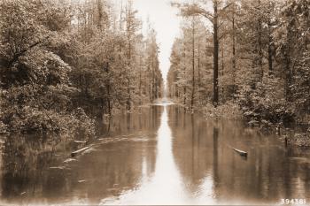
| Description: | Caption reads: "Some floods occur in a completely wooded drainage area. High water across Forest Service road No. 8 between Compartments 62-63 as a result of a 3.75 inch rainfall during the previous 24 hour period. This intermittent stream is usually dry." |
| Date: | 4/7/1938 |
| Collection: | Southern Research Station Historical Documents and Images |
| Keywords: |
experimental forest road |
| Location: | Crossett Experimental Forest; Ashley County; Arkansas |
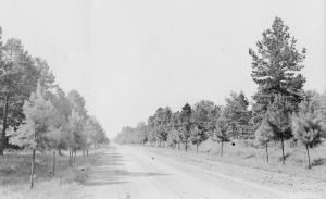
| Description: | Caption reads: "Typical 20 foot Forest Service constructed with CWA hand labor. Road to be gravelled and used for utilization of forest products as well as for protection and administration. Road #4 looking east from intersection of roads #4 and #6." |
| Date: | 7/23/1937 |
| Collection: | Southern Research Station Historical Documents and Images |
| Keywords: |
experimental forest planting road |
| Location: | Crossett Experimental Forest; Ashley County; Arkansas |
| Description: | Caption reads: "Example of roadside planting attempted on the Crossett Experimental Forest. Trees five years old at the time of photograph." |
| Date: | 7/23/1937 |
| Collection: | Southern Research Station Historical Documents and Images |
| Keywords: |
experimental forest road |
| Location: | Crossett Experimental Forest; Ashley County; Arkansas |
| Description: | Caption reads: "Crossett Experimental Forest road constructed in 1935. All work done with hand labor. Road # 4 at old Maxwell place looking West." |
| Date: | 3/16/1937 |
| Collection: | Southern Research Station Historical Documents and Images |
| Keywords: |
experimental forest oldfield road |
| Organisms: |
loblolly pine shortleaf pine |
| Location: | Crossett Experimental Forest; Ashley County; Arkansas |
| Description: | Caption reads: "About 1860, this road passed through a rich farming section. The fields have since seeded into shortleaf and loblolly pine and the road has been abandoned. Picture taken from a point 54 feet SE (S42oE) from Camera Station #5." |
| Date: | 11/10/1936 |


