| Collection: | Pacific Northwest Research Station, Alaska Image Archive |
| Keywords: |
plant ecology ecosystems vegetation types ecotypes |
| Location: | Alaska; Prince of Wales Island; Maybeso Valley |
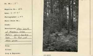
| Description: | Near mouth of Maybeso Creek. Mature spruce-hemlock type. On flat just above gauge. |
| Date: | 8/15/1961 |
| Collection: | Pacific Northwest Research Station, Alaska Image Archive |
| Keywords: |
plant ecology ecosystems vegetation types ecotypes |
| Location: | Alaska; Prince of Wales Island; Maybeso Valley |
| Description: | Plot No. 1, near mouth of Maybeso Creek. Mature spruce & hemlock type. Good site. |
| Date: | 8/15/1951 |
| Collection: | Pacific Northwest Research Station, Alaska Image Archive |
| Keywords: |
plant ecology ecosystems vegetation types ecotypes |
| Location: | Alaska; Prince of Wales Island; Twelvemile Arm |
| Description: | Muskeg & scrub type east of 12-mile arm. Elev. 480 ft, 1/2 mile from beach. Looking down drainage of 12 to 15% slope. Same area as Neg No. 441, 439. |
| Date: | 6/10/1950 |
| Collection: | Pacific Northwest Research Station, Alaska Image Archive |
| Keywords: |
plant ecology ecosystems vegetation types ecotypes |
| Location: | Alaska; Prince of Wales Island; Twelvemile Arm |
| Description: | Muskeg draw on east side of 12-mile arm. 16% slope runs between pot holes. Elev. 480 ft. Trees are L.P., WRC, AC, Mhem - poor quality. Same area as Neg No. 439, 442. |
| Date: | 6/10/1950 |
| Collection: | Pacific Northwest Research Station, Alaska Image Archive |
| Keywords: |
plant ecology ecosystems vegetation types ecotypes |
| Location: | Alaska; Prince of Wales Island; Twelvemile Arm |
| Description: | Scrub muskeg type E. side 12-mile arm, 1/2 mile from beach. Pot holes are terrace fashion, slope averages 8%. Each pot hole appears to be growing its own dam. |
| Date: | 6/10/1950 |


