| Collection: | Southern Research Station Historical Documents and Images |
| Keywords: | runoff |
| Location: | East Nesbitt Creek, Irons Fork Experimental Forest, Arkansas |
| Description: | Caption reads: "Hoover-Nesbitt runoff plots 9&10. View of surface runoff plots 9&10 taken from ladder tripod below plots. Plots are located on upper contour trail in East Nesbitt Creek. Covertype--open." |
| Date: | 10/23/1941 |
| Collection: | Southern Research Station Historical Documents and Images |
| Keywords: | runoff |
| Location: | East Nesbitt Creek, Irons Fork Experimental Forest, Arkansas |
| Description: | Caption reads: "Hoover-Nesbitt runoff plots 45&46. View of surface runoff plots 45&46 taken from ladder tripod below plots. Plots are located on lower contour trail in East Nesbitt Creek. Covertype--trees." |
| Date: | 11/18/1940 |
| Collection: | Southern Research Station Historical Documents and Images |
| Keywords: | runoff |
| Location: | East Nesbitt Creek, Irons Fork Experimental Forest, Arkansas |
| Description: | Caption reads: "Hoover-Nesbitt runoff plots 41&42. View of surface runoff plots 41&42 taken from ladder tripod below plots. Plots are located on lower contour trail in East Nesbitt Creek. Covertype--trees&reproduction." |
| Date: | 11/15/1940 |
| Collection: | Southern Research Station Historical Documents and Images |
| Keywords: | runoff |
| Location: | East Nesbitt Creek, Irons Fork Experimental Forest, Arkansas |
| Description: | Caption reads: "Hoover-Nesbitt runoff plots 47&48. View of surface runoff plots 47&48 taken from ladder tripod below plots. Plots are located on lower contour trail in East Nesbitt Creek. Covertype--reproduction (pine-hardwood)." |
| Date: | 10/28/1940 |
| Collection: | Southern Research Station Historical Documents and Images |
| Keywords: | runoff |
| Location: | East Nesbitt Creek, Irons Fork Experimental Forest, Arkansas |
| Description: | Caption reads: "Hoover-Nesbitt runoff plots 11&12. View of surface runoff plots 11&12 taken from ladder tripod below plots. Plots are located on upper contour trail in East Nesbitt Creek. Covertype--trees&reproduction." |
| Date: | 10/22/1940 |
| Collection: | Southern Research Station Historical Documents and Images |
| Keywords: | runoff |
| Location: | East Nesbitt Creek, Irons Fork Experimental Forest, Arkansas |
| Description: | Caption reads: "Hoover-Nesbitt runoff plots 13&14. View of surface runoff plots 13&14 taken from ladder tripod below plots. Plots are located on upper contour trail in East Nesbitt Creek. Covertype--reproduction (hardwood)." |
| Date: | 10/22/1940 |
| Collection: | Southern Research Station Historical Documents and Images |
| Keywords: | runoff |
| Location: | East Nesbitt Creek, Irons Fork Experimental Forest, Arkansas |
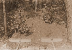
| Description: | Caption reads: "View of surface runoff plots 15&16 taken from ladder tripod below plots. Plots are located on upper contour trail in East Nesbitt Creek. Covertype--trees." |
| Date: | 10/22/1940 |
| Collection: | Southern Research Station Historical Documents and Images |
| Keywords: | runoff |
| Location: | East Nesbitt Creek, Irons Fork Experimental Forest, Arkansas |
| Description: | Caption reads: "Hoover-Nesbitt runoff plots 43&44. View of surface runoff plots 43&44 taken from ladder tripod below plots. Plots are located on lower contour trail in East Nesbitt Creek. Covertype--open." |
| Date: | 10/22/1940 |
| Collection: | Southern Research Station Historical Documents and Images |
| Keywords: |
weir stream gage |
| Location: | East Nesbitt Creek, Irons Fork Experimental Forest, Arkansas |
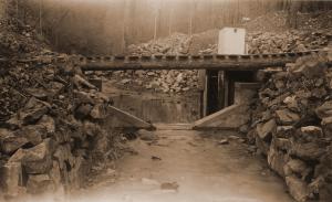
| Description: | Caption reads: "Figure 5. Gaging Point No. 2, East Nesbitt Creek. Watershed area 107.3 acres." From "Report on the Hoover-Nesbitt Creek Watersheds, Irons Fork Experimental Forest" by Norman E. Hawes, unpublished 10 page report written on April 9, 1940. |
| Date: | Apr-40 |
| Collection: | Southern Research Station Historical Documents and Images |
| Keywords: |
weir stream gage |
| Location: | East Nesbitt Creek, Irons Fork Experimental Forest, Arkansas |
| Description: | Caption reads: "Figure 6. Channel about 700 feet above Gaging Point No. 2, East Nesbitt Creek. Watershed area 75.0 acres above this point." Photo taken by E.S. Proctor in April 1940. From "Report on the Hoover-Nesbitt Creek Watersheds, Irons Fork Experimental Forest" by Norman E. Hawes, unpublished 10 page report written on April 9, 1940. |
| Date: | Apr-40 |


