| Collection: | Pacific Northwest Research Station, Alaska Image Archive |
| Keywords: |
hydrology water conservation, soil conservation and erosion watershed management studies on stream-flow and bank erosion: |
| Location: | Alaska; Prince of Wales Island; Indian Creek |
| Description: | RP1 at head of tidal zone. This type of locational marker used on study streams to tie data in place. Cruiser's axe for comparison. |
| Date: | 10/2/1950 |
| Collection: | Pacific Northwest Research Station, Alaska Image Archive |
| Keywords: |
hydrology water conservation, soil conservation and erosion watershed management studies on stream-flow and bank erosion: |
| Location: | Alaska; Prince of Wales Island; Indian Creek |
| Description: | RP2, location & reference marker used along study steams. Looks like "RP3" to me - DMB [Daniel M. Bishop]. |
| Date: | 10/2/1950 |
| Collection: | Pacific Northwest Research Station, Alaska Image Archive |
| Keywords: |
hydrology water conservation, soil conservation and erosion watershed management studies on stream-flow and bank erosion: miscellaneous |
| Location: | Alaska; Prince of Wales Island; Indian Creek |
| Description: | Oil tube for winter operation of stream gage. 12" diameter by 20' long of 20 gage galvanized iron. About 75 lbs. packed in. Tube placed in gage house well. Given charge of 5-10 gallons of kerosene. Float rests on kerosene which forms a non-freezing column through ice to unfrozen water below. |
| Date: | 10/2/1950 |
| Collection: | Pacific Northwest Research Station, Alaska Image Archive |
| Keywords: |
hydrology water conservation, soil conservation and erosion watershed management studies on stream-flow and bank erosion: |
| Location: | Alaska; Prince of Wales Island; Maybeso Valley |
| Description: | Maybeso Creek. |
| Date: | 10/1950 |
| Collection: | Pacific Northwest Research Station, Alaska Image Archive |
| Keywords: |
hydrology water conservation, soil conservation and erosion watershed management studies on stream-flow and bank erosion: |
| Location: | Alaska; Prince of Wales Island; Maybeso Valley |
| Description: | Looking upstream from foot log to top of gorge. Gage = 4', discharge = 782 sec.-ft. Minimum discharge = 10 sec. ft. Maximum discharge = 3460 sec. ft. |
| Date: | 9/22/1950 |
| Collection: | Pacific Northwest Research Station, Alaska Image Archive |
| Keywords: |
hydrology water conservation, soil conservation and erosion watershed management studies on stream-flow and bank erosion: miscellaneous |
| Location: | Alaska; Prince of Wales Island; Harris River |
| Description: | Gage house, gage at 2.86'. From C.P. above Dawson Landing. Discharge at this stage 505 sec.-ft. Minimum measured discharge = 17 sec.-ft. Maximum known discharge = 7360 sec.-ft. Maximum flood height in 1949 was over the top of the well. |
| Date: | 9/20/1950 |
| Collection: | Pacific Northwest Research Station, Alaska Image Archive |
| Keywords: |
hydrology water conservation, soil conservation and erosion watershed management studies on stream-flow and bank erosion: |
| Location: | Alaska; Prince of Wales Island; Maybeso Valley |
| Description: | C.P. on discharge foot log. Gage = 2.10 ft. Note fast flow & large boulders. Fish do not attempt to spawn in this section. Discharge = 229 sec. ft. Minimum discharge = 13 sec. ft. Maximum measured discharge = 3460 sec. ft. |
| Date: | 9/19/1950 |
| Collection: | Pacific Northwest Research Station, Alaska Image Archive |
| Keywords: |
animal ecology game and fish management hunting, shooting and fishing fish management: fishing |
| Location: | Alaska; Prince of Wales Island; Twelvemile Arm |
| Description: | Male & female pink salmon. Fresh run & not yet spawned out. 18" ruler along side typical specimens. |
| Date: | 9/16/1950 |
| Collection: | Pacific Northwest Research Station, Alaska Image Archive |
| Keywords: |
hydrology water conservation, soil conservation and erosion watershed management studies on stream-flow and bank erosion: |
| Location: | Alaska; Prince of Wales Island; Indian Creek |
| Description: | From C.P. up stream on Indian Creek. Low water - gage at .65'. Gage house at right. |
| Date: | 9/15/1950 |
| Collection: | Pacific Northwest Research Station, Alaska Image Archive |
| Keywords: |
hydrology water conservation, soil conservation and erosion watershed management studies on stream-flow and bank erosion: |
| Location: | Alaska; Prince of Wales Island; Indian Creek |
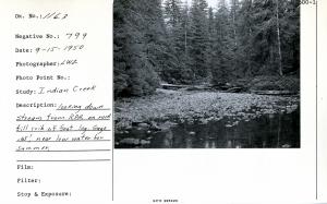
| Description: | Looking down stream from R.P.A. on rock fill crib of foot log. Gage .65', near low water for summer. |
| Date: | 9/15/1950 |
| Collection: | Pacific Northwest Research Station, Alaska Image Archive |
| Keywords: |
hydrology water conservation, soil conservation and erosion watershed management studies on stream-flow and bank erosion: |
| Location: | Alaska; Prince of Wales Island; Indian Creek |
| Description: | From C.P. below gage house looking down stream. Gage .65'. Logs packed in by high water. |
| Date: | 9/15/1950 |
| Collection: | Pacific Northwest Research Station, Alaska Image Archive |
| Keywords: |
hydrology water conservation, soil conservation and erosion watershed management studies on stream-flow and bank erosion: |
| Location: | Alaska; Prince of Wales Island; Maybeso Valley |
| Description: | Above R.P. 6 where stream enters Maybeso from south. Note flat valley type, mature, merchantable spruce. Noted scoured gravel & piled up debris from natural floods. |
| Date: | 9/1950 |
| Collection: | Pacific Northwest Research Station, Alaska Image Archive |
| Keywords: |
hydrology water conservation, soil conservation and erosion watershed management studies on stream-flow and bank erosion: |
| Location: | Alaska; Prince of Wales Island; Harris River |
| Description: | From C.P. at gage house. Low water, gage 1.05', discharge 54 sec.-ft. |
| Date: | 9/1950 |
| Collection: | Pacific Northwest Research Station, Alaska Image Archive |
| Keywords: |
hydrology water conservation, soil conservation and erosion watershed management studies on stream-flow and bank erosion: |
| Location: | Alaska; Prince of Wales Island; Maybeso Valley |
| Description: | Gage 1.02' just above RP5. Fresh windfall over older stuff. All natural. Typical of timbered flat where natural bank cutting creates these conditions. Note scoured bar & sand deposit from high water eddy. |
| Date: | 9/1950 |
| Collection: | Pacific Northwest Research Station, Alaska Image Archive |
| Keywords: |
animal ecology game and fish management hunting, shooting and fishing fish management: fishing |
| Location: | Alaska; Prince of Wales Island; Maybeso Valley |
| Description: | Fresh run female dog (chum) salmon. 12" scale at side. Note "pan" marks on dog salmon. Few dog salmon got over Maybeso Creek Falls in 1950. |
| Date: | 9/1950 |
| Collection: | Pacific Northwest Research Station, Alaska Image Archive |
| Keywords: |
hydrology water conservation, soil conservation and erosion watershed management studies of infiltration, run-off and water erosion:effects of forestry practices (polluted water) |
| Location: | Alaska; Prince of Wales Island; Calder Bay |
| Description: | Cat crossing just below spar pole. This jam may be 50-50 nature & logging. Most of this stream is much coarser gravel than this. |
| Date: | 8/9/1950 |
| Collection: | Pacific Northwest Research Station, Alaska Image Archive |
| Keywords: |
hydrology water conservation, soil conservation and erosion watershed management studies on stream-flow and bank erosion: |
| Location: | Alaska; Prince of Wales Island; Steelhead Creek |
| Description: | Natural debris on the east fork. Short distance above cutting, about 1/4 mile from mouth. Before logging Ivan Jones reports only 1/4 mile of steam possible to fish. |
| Date: | 8/8/1950 |
| Collection: | Pacific Northwest Research Station, Alaska Image Archive |
| Keywords: |
hydrology water conservation, soil conservation and erosion watershed management studies on stream-flow and bank erosion: |
| Location: | Alaska; Prince of Wales Island; Dog Salmon Creek |
| Description: | 1/4 mile from mouth. Note logs & debris. Some logging some natural, heavy brush growth. Coho fry all along this stream, also bones from last year's spawners. |
| Date: | 8/7/1950 |
| Collection: | Pacific Northwest Research Station, Alaska Image Archive |
| Keywords: |
hydrology water conservation, soil conservation and erosion watershed management studies on stream-flow and bank erosion: |
| Location: | Alaska; Prince of Wales Island; Little Steelhead Creek |
| Description: | High water channel in lower portion of stream shows flood occurrence. |
| Date: | 8/7/1950 |
| Collection: | Pacific Northwest Research Station, Alaska Image Archive |
| Keywords: |
hydrology water conservation, soil conservation and erosion watershed management studies on stream-flow and bank erosion: effects of forestry practices (polluted water) |
| Location: | Alaska; Prince of Wales Island; Little Steelhead Creek |
| Description: | Cat road across oxbow bend of old stream now forms channel. Note good gravel. |
| Date: | 8/7/1950 |
| Collection: | Pacific Northwest Research Station, Alaska Image Archive |
| Keywords: |
hydrology water conservation, soil conservation and erosion watershed management studies on stream-flow and bank erosion: effects of vegetation |
| Location: | Alaska; Prince of Wales Island; Dog Salmon Creek |
| Description: | Logs - debris in unlogged stream. Dog Salmon Creek, Salt Lake. |
| Date: | 8/7/1950 |
| Collection: | Pacific Northwest Research Station, Alaska Image Archive |
| Keywords: |
regeneration and formation of stands tending of stands and trees thinnings |
| Location: | Alaska; Prince of Wales Island; Karta Bay |
| Description: | 21- year old blaze on western hemlock 11" dbh. Plot 1, area 1, Karta Bay. |
| Date: | 8/1950 |
| Collection: | Pacific Northwest Research Station, Alaska Image Archive |
| Keywords: |
regeneration and formation of stands tending of stands and trees thinnings |
| Location: | Alaska; Prince of Wales Island; Karta Bay |
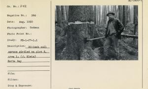
| Description: | 30-inch cull spruce girdled on plot 3, area 1. (J. Klein) Karta Bay. |
| Date: | 8/1950 |
| Collection: | Pacific Northwest Research Station, Alaska Image Archive |
| Keywords: |
regeneration and formation of stands tending of stands and trees thinnings |
| Location: | Alaska; Prince of Wales Island; Karta Bay |
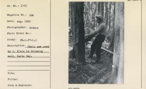
| Description: | Chain saw used by J. Klein in thinning work, Karta Bay. |
| Date: | 8/1950 |
| Collection: | Pacific Northwest Research Station, Alaska Image Archive |
| Keywords: |
regeneration and formation of stands tending of stands and trees thinnings |
| Location: | Alaska; Prince of Wales Island; Karta Bay |
| Description: | Corner post plot 1, area 2 corner 4. Stake is still standing but shows deterioration, espl at ground line. Karta Bay. |
| Date: | 8/1950 |
| Collection: | Pacific Northwest Research Station, Alaska Image Archive |
| Keywords: |
regeneration and formation of stands tending of stands and trees thinnings |
| Location: | Alaska; Prince of Wales Island; Karta Bay |
| Description: | Crown before thinning plot 1, area 1, Karta Bay. See neg. no. 376 for view after thinning. This is same camera point as neg. 357. |
| Date: | 8/1950 |
| Collection: | Pacific Northwest Research Station, Alaska Image Archive |
| Keywords: |
regeneration and formation of stands tending of stands and trees thinnings |
| Location: | Alaska; Prince of Wales Island; Karta Bay |
| Description: | Crown before thinning plot 1, area 1. Crown competition had reduced crown ratio below optimum. Karta Bay. Same camera point as neg. no. 355. |
| Date: | 8/1950 |
| Collection: | Pacific Northwest Research Station, Alaska Image Archive |
| Keywords: |
regeneration and formation of stands tending of stands and trees thinnings |
| Location: | Alaska; Prince of Wales Island; Karta Bay |
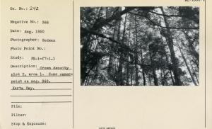
| Description: | Crown condition plot 2, area 1. Same camera point as neg. 369. |
| Date: | 8/1950 |
| Collection: | Pacific Northwest Research Station, Alaska Image Archive |
| Keywords: |
regeneration and formation of stands tending of stands and trees thinnings |
| Location: | Alaska; Prince of Wales Island; Karta Bay |
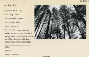
| Description: | Crown density after thinning plot 1, area 1, Karta Bay. Same camera point as 377. See neg. 358 for crown view before thinning. |
| Date: | 8/1950 |
| Collection: | Pacific Northwest Research Station, Alaska Image Archive |
| Keywords: |
regeneration and formation of stands tending of stands and trees thinnings |
| Location: | Alaska; Prince of Wales Island; Karta Bay |
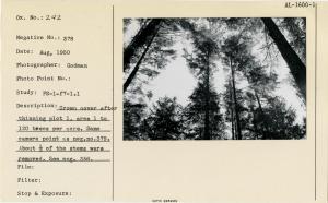
| Description: | Crown density after thinning plot 1, area 1, to 120 trees per acre. Same camera point as neg. no. 379. About 1/2 of the stems were removed. See neg. 356. |
| Date: | 8/1950 |
| Collection: | Pacific Northwest Research Station, Alaska Image Archive |
| Keywords: |
regeneration and formation of stands tending of stands and trees thinnings |
| Location: | Alaska; Prince of Wales Island; Karta Bay |
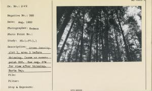
| Description: | Crown density plot 1, area 1 before thinning. Same as camera point neg. 359. See neg. no. 374 for view after thinning. Karta Bay. |
| Date: | 8/1950 |
| Collection: | Pacific Northwest Research Station, Alaska Image Archive |
| Keywords: |
regeneration and formation of stands tending of stands and trees thinnings |
| Location: | Alaska; Prince of Wales Island; Karta Bay |
| Description: | Crown density plot 2, area 1. Same camera point as neg. 368. Karta Bay. |
| Date: | 8/1950 |
| Collection: | Pacific Northwest Research Station, Alaska Image Archive |
| Keywords: |
regeneration and formation of stands tending of stands and trees thinnings |
| Location: | Alaska; Prince of Wales Island; Karta Bay |
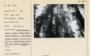
| Description: | Crown density plot 3, area 1, after thinning to 67% b.a. Noticeable crown release. Thinning to 2/3 b.a. left 54 more trees per acre than on adjacent plot thinned to 120 trees. |
| Date: | 8/1950 |
| Collection: | Pacific Northwest Research Station, Alaska Image Archive |
| Keywords: |
regeneration and formation of stands tending of stands and trees thinnings |
| Location: | Alaska; Prince of Wales Island; Karta Bay |
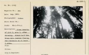
| Description: | Crown density plot 3, area 1, after thinning. Almost half the trees were removed freeing the residuals on at least 2 sides. |
| Date: | 8/1950 |
| Collection: | Pacific Northwest Research Station, Alaska Image Archive |
| Keywords: |
regeneration and formation of stands tending of stands and trees thinnings |
| Location: | Alaska; Prince of Wales Island; Karta Bay |
| Description: | Crown density plot 3, area 1, before thinning. Very few trees received light on more than 2 sides of their crowns. |
| Date: | 8/1950 |
| Collection: | Pacific Northwest Research Station, Alaska Image Archive |
| Keywords: |
regeneration and formation of stands tending of stands and trees thinnings |
| Location: | Alaska; Prince of Wales Island; Karta Bay |
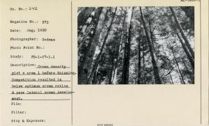
| Description: | Crown density plot e, area 1, before thinning. Competition resulted in below optimum crown ratios & poor lateral crown development. |
| Date: | 8/1950 |
| Collection: | Pacific Northwest Research Station, Alaska Image Archive |
| Keywords: |
regeneration and formation of stands tending of stands and trees thinnings |
| Location: | Alaska; Prince of Wales Island; Karta Bay |
| Description: | Density of plot 3 area 1 after thinning to 67% b.a. (L. Zach in photo). |
| Date: | 8/1950 |
| Collection: | Pacific Northwest Research Station, Alaska Image Archive |
| Keywords: |
regeneration and formation of stands tending of stands and trees thinnings |
| Location: | Alaska; Prince of Wales Island; Karta Bay |
| Description: | Incipient decay showing at butt of a 10.4" hemlock cut during thinning. Plot 1, area 2. Karta Bay. |
| Date: | 8/1950 |
| Collection: | Pacific Northwest Research Station, Alaska Image Archive |
| Keywords: |
regeneration and formation of stands tending of stands and trees thinnings |
| Location: | Alaska; Prince of Wales Island; Karta Bay |
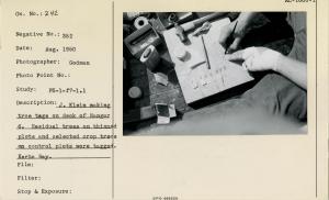
| Description: | J. Klein making tree tags on deck of Ranger 6. Residual trees on thinned plots and selected crop trees on control plots were tagged. Karta Bay. |
| Date: | 8/1950 |
| Collection: | Pacific Northwest Research Station, Alaska Image Archive |
| Keywords: |
regeneration and formation of stands tending of stands and trees thinnings |
| Location: | Alaska; Prince of Wales Island; Karta Bay |
| Description: | Large fluted hemlock axe-girdled. On plot 3, area 1. Karta Bay. (L. Zach). |
| Date: | 8/1950 |
| Collection: | Pacific Northwest Research Station, Alaska Image Archive |
| Keywords: |
regeneration and formation of stands tending of stands and trees thinnings |
| Location: | Alaska; Prince of Wales Island; Karta Bay |
| Description: | Larry Zach holding branch of western hemlock felled 2 years before. Very few needles but most fine branches remain. |
| Date: | 8/1950 |
| Collection: | Pacific Northwest Research Station, Alaska Image Archive |
| Keywords: |
regeneration and formation of stands tending of stands and trees thinnings |
| Location: | Alaska; Prince of Wales Island; Karta Bay |
| Description: | Loss from windthrow, plot 4, area 1. Karta Bay (Clyde E. Millo). Note typical shallow rooting. |
| Date: | 8/1950 |
| Collection: | Pacific Northwest Research Station, Alaska Image Archive |
| Keywords: |
regeneration and formation of stands tending of stands and trees thinnings |
| Location: | Alaska; Prince of Wales Island; Karta Bay |
| Description: | Numbers are written on tree tags with India ink after the aluminum tags are polished with talc. Karta Bay. 1950. |
| Date: | 8/1950 |
| Collection: | Pacific Northwest Research Station, Alaska Image Archive |
| Keywords: |
regeneration and formation of stands tending of stands and trees thinnings |
| Location: | Alaska; Prince of Wales Island; Karta Bay |
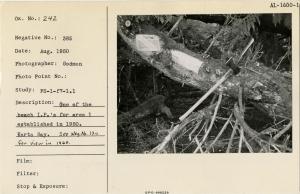
| Description: | One of the beach I.P.'s for area 1 established in 1950. Karta Bay. See neg. no. 120 for view in 1960. |
| Date: | 8/1950 |
| Collection: | Pacific Northwest Research Station, Alaska Image Archive |
| Keywords: |
regeneration and formation of stands tending of stands and trees thinnings |
| Location: | Alaska; Prince of Wales Island; Karta Bay |
| Description: | Plot 1, area 1, stand conditions after thinning. See neg. no 355 for view before thinning. Karta Bay |
| Date: | 8/1950 |
| Collection: | Pacific Northwest Research Station, Alaska Image Archive |
| Keywords: |
regeneration and formation of stands tending of stands and trees thinnings |
| Location: | Alaska; Prince of Wales Island; Karta Bay |
| Description: | Plot 1, area 1, stand conditions before thinning. See neg. no. 379 for view after thinning. Karta Bay. |
| Date: | 8/1950 |
| Collection: | Pacific Northwest Research Station, Alaska Image Archive |
| Keywords: |
regeneration and formation of stands tending of stands and trees thinnings |
| Location: | Alaska; Prince of Wales Island; Karta Bay |
| Description: | Plot 1, area 2, before thinning to 64% of ba. Karta Bay. |
| Date: | 8/1950 |
| Collection: | Pacific Northwest Research Station, Alaska Image Archive |
| Keywords: |
regeneration and formation of stands tending of stands and trees thinnings |
| Location: | Alaska; Prince of Wales Island; Karta Bay |
| Description: | Plot 1, area 2, crown cover before thinning. 51 cords of pulp wood was removed in thinning this 96-year-old stand. Karta Bay. |
| Date: | 8/1950 |
| Collection: | Pacific Northwest Research Station, Alaska Image Archive |
| Keywords: |
regeneration and formation of stands tending of stands and trees thinnings |
| Location: | Alaska; Prince of Wales Island; Karta Bay |
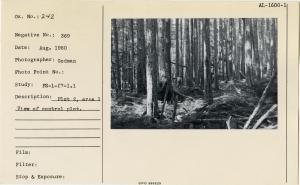
| Description: | Plot 2, area 1. View of control plot. |
| Date: | 8/1950 |
| Collection: | Pacific Northwest Research Station, Alaska Image Archive |
| Keywords: |
regeneration and formation of stands tending of stands and trees thinnings |
| Location: | Alaska; Prince of Wales Island; Karta Bay |
| Description: | Plot 3, area 1, after thinning to 67% b.a. (J. Klein). 130 trees per acre were removed. |
| Date: | 8/1950 |


![RP2, location & reference marker used along study steams. Looks like "RP3" to me - DMB [Daniel M. Bishop]. RP2, location & reference marker used along study steams. Looks like "RP3" to me - DMB [Daniel M. Bishop].](/rds/imagedb/images/_thm/31437.jpg)


