|
|
AWAE Program Headquarters
322 East Front St., Ste 401
Boise, ID 83702
(208) 373-4340
Rocky Mountain Research Station Headquarters
2150 Centre Ave., Bldg A
Fort Collins, CO 80526
(970) 295-5923
|
|

|
|
Rocky Mountain Research Station Home > Science Program Areas > Air, Water and Aquatics > Flagstaff Lab > Southwest Watershed Team Research History > BCEW Study Methods
Southwest Watershed Science Team of the AWAE
|
Beaver Creek Experimental Watershed (BCEW) Study Methods |
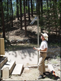
Boris Poff in the process of reinstating WS 9, finishing the installation of the solar panel to provide power for the data logger within the shed
|
Climate
Climate measurements are taken on a continuous basis. Water measurement or sampling is on a continuous basis, depending on flow conditions. Vegetation and forest floor will be measured before and two years after treatment. Two meterological stations used in the original BCEW research have been reactivated using automated weather stations. Additional recording rain gages will be deployed as needed.
Water Flow
Streamflow will be measured on supercritical, trapezoidal flumes. See the following web site for more details: http://ag.arizona.edu/OALS/watershed/beaver/bcstream.html.
Water yield based on stage height and flume ratings are measured with modern electronic stage height sensors. Stream stage heights are converted to flow volumes based on hydraulic rating formulas. Treatment responses will be compared using existing flow regressions and comparisons with the control watershed (World Meteorological Organization 1980, Baker 1986).
|
Vegetation
Overstory composition, understory, and forest floor will be determined on the existing permanent plots (Table 1). The methods described by Weatherspoon and McIver (2000) for the Fire and Fire Surrogate Study will be used as much as possible. Methods used in the previous surveys (1960s, 1975, and mid-1990s) will be repeated in order to keep the methods consistent with the previous surveys. (Barger and Ffolliott 1969, Clary 1964). The overstory will be measured again by point sampling using a Basal Area Factor 25 prism. The understory, by species, will be remeasured using a double sampling procedure with 0.88 m2 plots. Clip plots are taken every 10 sampling points to correct field measures of green weight to actual oven dry weight. |

Hydrologist Boris Poff installing stage height recorder in the newly constructed instrumentation shed of Wastershed 9. |
Forest Floor
The forest floor will be measured using the method of Ffolliott and others (1968) which is similar to the Fire and Fire Surrogate method (Weatherspoon and McIver 2000). Each watershed has a systematic plot design and a procedure of multiple random starts will be used again (Shiue 1960). Litter depth will be measured without compressing the layers at four points within 1 m (3 ft) of the plot center, one in each quadrant. An average of the four depth measurements, recorded to the nearest 2.5 mm (0.1 in), will be recorded as the representative forest floor depth at each plot. The weight of individual forest floor layers will be obtained from 929 cm2(1 ft2) samples taken in one randomly selected quadrant, randomly selected from each set of 10 plots. These samples will be bagged and brought into the laboratory to determine oven-dry weights. Corresponding depth measurements will be taken at the four sides of the 929 cm2litter samples.
To determine the carbon (C), nitrogen (N), phosphorus (P), and cation content of forest floor, three samples will be collected adjacent to each forest floor measurement plot, sorted, dried, and weighed determine mass. Depending on the characteristics of the individual site, 1-3 forest floor horizons or strata may be sampled separately. |
Soils
Mineral soil will be sampled for C, N, and macronutrient content. Three samples of the A horizon will be collected to a maximum depth of 7.5 cm for analysis at each of the litter measurement plots. One will be mineral soil where the litter is removed and the other two randomly selected from the other three quadrants at the same distance. Samples will not be composited prior to chemical analysis.
Forest floor and mineral soil samples will be analyzed by more up-to-date methods than those discussed by Weatherspoon and McIver (2000). Subsamples of the forest floor samples and mineral soil samples will be analyzed for total C and N content by a ThermoElectron Flash EA CNS Analyzer.
The other chemical constituents will be analyzed by standard methods using a Lachat Quick Chem 8000 Flow Injector Analyzer for nitrate, ammonia, phosphate, and total phosphorus, and a Dionex Liquid Chromatograph for cations (sodium, potassium, magnesium, and calcium). No analysis of nutrient availability or soil microbiological diversity will be done. Each vegetation sample plot will be also surveyed to determine the amounts of bare soil, woody debris, and rock using 10 m line transects. |

Boris Poff and Duncan Leao enjoying their ride across in a gondola
We hope you enjoyed your visit as much as we enjoy our research! Thank you for visiting and come again soon as our website is always being updated. |
|
|
|