
Stop 5: Caney Day Use Area
Located along the Glade Top Trail National Forest Scenic Byway, this day use area is situated on one of the Ozark glades.
Spring and summer blooming wildflowers cover the area in natural beauty. You’ll find Indian Paintbrushes, Evening primrose, shooting star, purple and yellow coneflower, black-eyed susans, daisies, just to name a few.
The fall colors offer a breathtaking display only nature can provide of the glade. This is a popular place to stop and take photos of the fall color change on the surrounding hillsides.
!Agents of Discovery Mission Site!
The Glade Top Trail has a secret mission for kids (or adults) to play when visiting! Download the Agents of Discovery app to your mobile device, search for the Caney Picnic Area Glade Top Trail in the available missions and have some extra fun when visiting this day use area.
More on how to how to use the app
Open glade country surrounds the picnic area. On glades such as these, the notorious Bald Knobbers met and planned their raids. The Bald Knobbers were a group of vigilantes in the Ozark region of southwest Missouri from 1885 to 1889.
You’ll also be treated to the site of the old Caney Fire Tower, no longer in use and not open to the public, the tower was once used by Forest personnel to spot wildfires across the landscape.
The area is popular for reunions and weddings.
General Information
January - December
Day Use Area available 6 am to 10 pm
- Permits are required for 75 people or more, but smaller groups can also get one.
- A permit does not reserve the site or give permit holders exclusive use of the area.
- Wedding and other gatherings can be done through a Non-commercial use permit at no fee.
- Note: The Forest Service will post signs that an event is occurring, but will not post reservation signs.
- No overnight camping in day use areas at any time of year.
- Dogs must be on a 6 foot leash in the day use area
- No trash containers; please pack out all your trash.
- Fireworks are prohibited.
No fees are required for this site
No fee
Dogs are allowed at campsites and developed recreation areas; however, they should not be allowed to run loose in recreation areas where they will disturb other forest visitors. Be mindful of the impact a barking dog can have on other forest visitors.
- Keep dogs on a six-foot, or shorter, leash when they are not inside an enclosed vehicle or tent.
- Store dog food in bear-resistant containers and feed your pet away from the campsite.
- Pick up and bag your dog’s waste. Place it in a provided trash receptacle or pack it out.
- Do not leave your dog unattended at any time.
- Do not leave your dog in the vehicle on a hot day.
- Keep your dog in your tent or vehicle at night.
- Ensure that there is ample water available for your pet.

Address: 1006 S. Jefferson Ava, MO 65608
Phone: 417-683-4428
Hours: 8:00 am - 4:30 pm, Monday to Friday; District Offices closed 1 - 1:30 for lunch (Closed on federal holidays)
Office Email: sm.fs.marktwainnf@usda.gov
Getting There
Latitude / Longitude
Latitude: 36.74475
Longitude: -92.758993
Directions
From Ava, MO
- go south on Hwy 5 for three miles to Hwy A,
- turn right/west on Hwy A and drive 4 miles to Smallett Junction,
- turn left/south on A409 and go 3 miles to Forest Road 147
- Turn left onto Forest Road 147 for 6 miles to the day use area.
- The day use area will be on the left.
Parking
30 vehicles on the opposite side of the road
Facility and Amenity Information
Accessibility
The outhouse is accessible.
Restrooms
Restrooms are available at this site.
Water
Potable water is not available at this site.
Picnic Tables
Picnic tables are available at this site.
3 picnic sites
Recreation Opportunities
Picnicking - Single Info
In the day use area there are several picnic tables on a 30x40 foot concrete pad that you get to on a hard-packed dirt trail from the parking area. There is one grill shared by all the tables.
The amphitheater is down several rock steps and slopes down, and can seat between 75 – 100 people. Wooden benches are provided or you can bring your own chair.
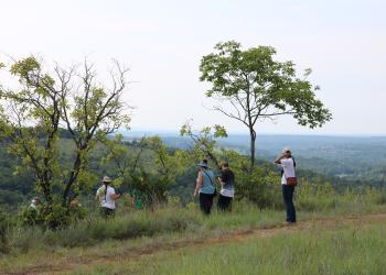
The road is on the ridge line, providing a view of the glades. As you walk through the day use area, seating is on the hillside as you walk down to the amphitheater from the roadway. The seating faces a beautiful vista of the glades, perfect for taking pictures.
No. of Sites
3 tables
Picnicking - Groups Info
There is no picnic pavilion, however visitors can use the picnic tables as a group, if they are available.
Viewing Plants Info
Within this wide and varied landscape there exists a diverse array of plants. Of the roughly 2800 species of plant in Missouri, about two-thirds can be found on the Forest. While most can be found commonly throughout the Forest, less common species can be found in specific natural communities such as calcareous fens, acid seeps, and glades (limestone, dolomite and igneous).
What to look for
- Native - MDC Field Guide
- Non-Native - Mark Twain NNIS | MDC Problem Plant Control
- Threatened, Endangered and Candidate Species - Mark Twain | MDC Species
Viewing Wildlife Info
The ultimate wildlife viewing experience is watching animals in their habitat. Here are some helpful tips to become a wildlife friendly viewer:
- Use the right tools - A field guide, a pair of binoculars and a camera. Wear clothing that is appropriate for the season and activity.
- Watch at dawn and dusk - This is the time when most wildlife species are active enough to view.
- Keep your distance - Maintain a distance that is comfortable for the wildlife.
- Stay quiet - Move slowly and quietly to increase your chances of viewing wildlife, and to avoid stressing the animals you wish to watch.
- Do not feed the wildlife - There is plenty of food available in the wild. Human food can cause digestive problems, provide improper nutrition, and even kill an animal.
An online version of the Missouri Wildlife Viewing Guide is available on their website
Viewing Scenery Info
You get a vista view from the ridge too looking out on the Ozark highlands.
Recreation Groups
This 23-mile Scenic Byway is named for the beautiful glades that surround the ridge tops where the Scenic Byway traverses.