

Visitor Maps and Guides
Visitor Map Finder Application
Find visitor maps by location.
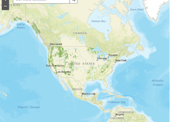
Interactive Visitor Map
Looking for you next adventure on the Chugach or Tongass National Forest? Check out our Interactive Visitor Map and start planning today.
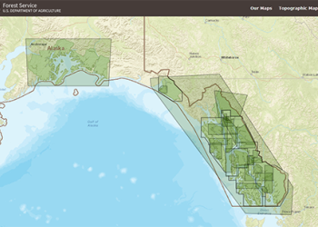
Forest Service Topographic Maps
Download Forest Service topographic quadrangles. Quads include land ownership, Forest Service roads, trails and recreation sites.
Alaska Region GeoHub
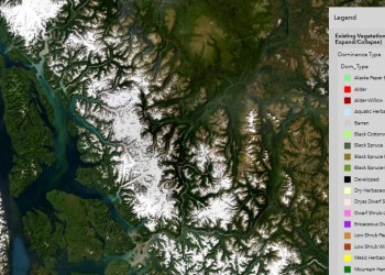
Use the navigation tools to explore the different Story Maps and Web Apps, and data that the US Forest Service has produced for the Alaska Region.
Motor Vehicle Use Maps (MVUM)

The MVUM displays National Forest System (NFS) routes (roads and trails) or areas designated as open to motorized travel. The MVUM also displays allowed uses by vehicle class (ex. highway-legal vehicles, vehicles less than 50 inches wide and motorcycles), seasonal allowances, distance allowances, and provides information on other travel rules and regulations.
Routes not shown on the MVUM are not open to public motor vehicle travel. Routes designated for motorized use may not always be signed on the ground but will be identified on the MVUM. It will be the public’s responsibility to reference the MVUM to stay on designated routes for motor vehicle use.
Alaska Region Maps
-
Image

- Tongass National Forest maps and guides
- Alaska Geospatial Council
- FSGeodata Clearinghouse
- USGS Topographic Maps
- Avenza App Maps for the Alaska Region

Geospatial Data
- Alaska Region Maps and Apps
- Alaska Region GeoHub
- Forest Service Geospatial Data Viewer
- Forest Service Geospatial Data Download
Contacts
- Kim Homan
Geospatial Program Manager
907-318-8061
Kim.Homan@usda.gov - Justin Martens
Regional GIS Coordinator
907-713-5718
Justin.Martens@usda.gov - Jacob Hofman
Cartographer
907-586-7887
Jacob.Hofman@usda.gov - Melinda Lamb
Geospatial Services Specialist
907-586-8761
Melinda.S.Lamb@usda.gov - Joseph Moore
Geospatial Data Specialist
Joseph.Moore2@usda.gov - Dustin Wittwer
Remote Sensing Coordinator
907-586-8764
Dustin.Wittwer@usda.gov
Disclaimer: The USDA Forest Service recognizes that some of the terms found on these archived documents may be considered offensive to many. These terms are not representative of USDA policy but reflect the actual place names that were in use at the time of original publication of these historical maps and documents.