Welcome to the Southwestern Region
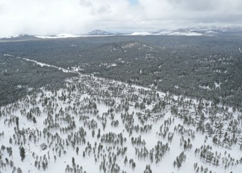
The Southwestern Region covers more than 20.6 million acres, boasting thousands of recreation opportunities spread across six national forests in Arizona, five national forests and a national grassland in New Mexico, and one national grassland each in Oklahoma and the Texas panhandle.
The elevation ranges from 1,600 feet above sea level and an annual rainfall of 8 inches in Arizona's lower Sonoran Desert to 13,171-foot high Wheeler Peak and over 35 inches of precipitation a year in northern New Mexico.
Find a Forest
Apply Now! Permanent Fire Positions Now Available

Applications are due through USAJobs by September 23.
Connect with a Fire, Fuels and Aviation Management recruiter to learn about future openings and hiring events.
Discover Our Junior Ranger Books
Kids can learn about the national forests and grasslands in Arizona and New Mexico through fun activities.
Introducing the AZT Comprehensive Plan

The final comprehensive plan for the Arizona National Scenic Trail was signed on June 9.