|
Bob Simonson, Program Leader |
|
San Dimas Technology
& Development Center
444 E Bonita Ave
San Dimas, CA 91773
(909) 599-1267
REY FARVE, Project Leader
|
Using ike in Inventory & Monitoring With the push of a few buttons the ike's digital camera and the Data Capture Application are ready to record data. The ike's camera allows users to preview the target with cross hairs showing where the laser range finder is pointing. With a couple of taps of the stylus, the image is captured (showing the cross hairs if desired). Associated with that image is not only the date, time and bearing, but the ike's clinometer, range finder, and GPS work together to record either the location of the device (in hand) or the target in the cross hairs.
|
||||||||||||||||||||||||
These combined features distinguish the ike from other devices that link digital images with geospatial data (see Similar Devices). The range finder's ability to enable the user to obtain GPS reading without having to physically occupy the desired target location gives the ike a significant advantage over similar devices by allowing users to collect information on sites that are unsafe to occupy, time-consuming to occupy, or simply inaccessible. Data Capture Process The standard ike configuration includes two Data Capture Applications (DCA) to capture basic information: the Standard DCA and the ArcPad Application Builder DCA. Both capture GPS log files that can later be post processed by Differential GPS to improve accuracy of GPS locations. Standard Data Capture Application (DCA). The standard DCA allows the user to capture data about a location (point), add a label and comments, and store the data in a Comma Separated Value (CVS) file. ArcPad Application Builder DCA (AABDCA). The AABDCA allows the user to capture data about a location (point) and launch an ArcPad Application Builder script which allows the user to generate a map of points and include additional information.
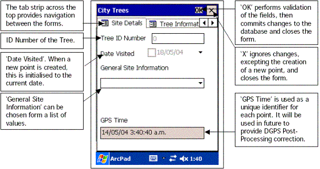
Software Development Kit. In addition to the above Data Capture Processes, a Software Development Kit can be purchased which allows the knowledgeable users to customize standard DCAs to create specific forms to meet specific needs. Surveylab has a "sd_citytrees" form installed on the ike that is provided with the AABDAC. It is used primarily to illustrate how a form can be developed to that ensure that specific data is taken at sites. "City Trees" form that comes loaded on the ike.
Note: Mark Hudy (National Aquatic Ecology Unit Leader) and his crew have used the ike 300 in conducting numerous fisheries inventories. They have developed customized forms to use with the ike to assist in data collection. Furthermore, he (and his group) has used shapefiles exported from the ike and integrated them with the MediaMapper® program to generate webpages. For more details see the Smith Creek Photo Monitoring 2005 file. |
|||||||||||||||||||||||||