Districts

SMOKEY BEAR RANGER DISTRICT

901 Mechem Dr.
Ruidoso, NM 88345

The Smokey Bear Ranger District, 423,416 acres in size, ranges in elevation from 5,400 to 11,580 feet.  There are two wilderness areas, White Mountain and Capitan, totaling just under 84,000 acres.  Ski Apache Resort, one of the largest ski areas in the Southwest, is also located on the district. 

Vegetation ranges from semi-desert plants, pinyon pine, and juniper to spruce, fir, and high-elevation grasses and forbs. Weather is directly tied to elevation. In the summer, expect sweltering temperatures down in the desert and the necessity of a sweater or jacket in the high country. Springtime is usually dry and windy, while July and August are the rainy months, with frequent afternoon showers or thunderstorms. A combination of high elevation and abundant moisture result in a beautiful array of colors from flowering plants during the summer months. Perhaps the most beautiful time of year is in the fall when oaks, maples, and aspens wrap the mountain slopes in breathtaking colors. 

The towns of Lincoln, where one of the famous shoot-outs of Billy the Kid took place, and Capitan, the burial site of the original Smokey Bear, are conveniently located near the District. 

Smokey Bear Vicinity Map


SACRAMENTO RANGER DISTRICT

4 Lost Lodge Rd
Cloudcroft, NM 88317

The Sacramento Ranger District, 548,865 acres in size ranges in elevation from 4,600 to 9,695 feet.  Visitors may enjoy camping, picnicking, fishing, hunting, hiking, bird watching, motorized activities, sight-seeing, or horseback riding, plus snowmobiling, inner-tubing, cross-country, and downhill skiing.

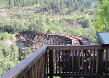
Between Cloudcroft and Alamogordo on US-82 is the only highway tunnel in Southern New Mexico.  A parking area just west of the tunnel affords a spectacular view of Fresnal Canyon, White Sands, and the Tularosa Basin.  Just NW of Cloudcroft along US82  is a vista (viewing area) of the historical Mexican Canyon Trestle.  Harking back to an era when steam trains climbed the Sacramento Mountains to reach timber, this railroad trestle is the largest and one of the few fully remaining trestles in the mountains. Visitors can also visit the trestle from a series of trails at the Trestle Recreation Site; a day-use picnic and popular hiking site.

Another area of interest is the National Solar Observatory in Sunspot. Many magnificent vistas may be seen while driving the Scenic Byway to the observatory.  The observatory is open for self-guided tours from 8:00 am to 5:00 pm daily and for guided tours on Saturdays at 2:00 pm from May 1 through October 1.

Trees such as Douglas Fir, Ponderosa pine, aspen, and oak envelope the hiking trails and are home to a great variety of birds.  Wildflowers such as Blue Columbine, Alpine Daisy, Dinquefoil, Penstemon, and Larkspur carpet the forest and meadows in splendor.  White-tailed deer, mule deer, ringtail cat, black bears, Rocky Mountain elk, plus raccoons and porcupines are only a few of the wildlife that may be seen. 

Sacramento Vicinity Map

GUADALUPE RANGER DISTRICT

5203 Buena Vista Dr.
​Carlsbad, NM 88220

The Guadalupe Ranger District, 288,540 acres in size, is a magical place where gently rolling hills meet deep rough canyons atop the Guadalupe Mountain Range. Chihuahuan Desert plant life mixes with piñon, juniper, and ponderosa pine woodlands to create what the Spanish called “El Espejismo del Desierto.”  This “Mirage in the Desert” is the perfect place for seekers of solitude or people who wish to “get away from it all.”

The Guadalupe Mountain Range itself is an exposed portion of the ancient Capitan barrier reef. Most of the Guadalupe Ranger District is the back-reef, where sedimentary limestone formations are rich with Permian Age fossils.  The District varies in elevation from 3,500 feet on the northern part to 7,500 feet on the southern part of the District.

The northern two-thirds of the District consists of rolling hills and canyons, which run uniquely to the east towards the Pecos River. In this area, you will find all varieties of cacti and agaves blooming for a short time in late Spring. The Sitting Bull Falls Recreation Area, Rim Road (Forest Road 67), and Last Chance Canyon Trail (T226) are popular sights of interest for this part of the District.

The southern third of the District consists of deep canyons with sheer cliffs and plant life unusual for this part of New Mexico such as Chinkapin oak and Douglas-fir trees. The Texas Madrone tree with its shedding bark can also be seen in this area.

Many activities are enjoyed on the District. Take a scenic drive on Forest Road 540 to Five Points Vista or hike a portion of the Camp Wilderness Trail off Forest Road 3008. There are many other primitive trails to hike, but you must be prepared for the journey. This breathtaking area is remote with no drinking water available and no available services. Most of the District’s primitive caves are in the steep, rugged canyons of this area. Wildlife is plentiful throughout the District, but viewing is best in the early morning and late evening hours.

All caves on the Lincoln National Forest, including those on the Guadalupe Ranger District, require personal equipment and a permit for entry. Cave permits are free, but due to limited access, permits are issued on a first-come, first-served basis.

Sitting Bull Falls Recreation Area is the jewel of the district. A 150-foot waterfall cascades down to natural pools where you can cool off on a hot summer’s day.  Picturesque, stone-built picnic areas and restrooms, accessible cooking grills, along with a variety of hiking trails, make a trip to Sitting Bulls Falls Recreation Area a day of fun for the whole family.

Guadalupe Vicinity Map