
Oracle Ridge #1
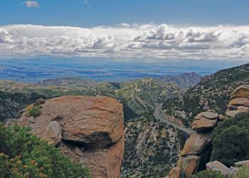
This trail is listed as #1 for some very good reasons. First, it follows one of the earliest known routes to the top of Mt. Lemmon. Second, it is believed to be the trail that John and Sara Lemmon followed, in the early 1880s, on their trip to the summit of the mountain which was later named in Sara’s honor. This trail is reportedly where biologist Lemmon saw his first Arizona pine. Actually a subspecies or variety of ponderosa pine, this was the first of roughly 100 plant species and subspecies Lemmon catalogued in the state’s southern mountains. In spite of the fact that the Oracle Ridge Trail has been traveled for so long a time, it is quite hard to follow in a number of places. One reason is that the area through which it passes has long been a center of mining and prospecting activity. As a result, old mining roads and bulldozer paths have obscured the trail in several places. If you’re a history buff, you’ll appreciate the old and not-so-old mines you encounter along this route. If your interests tend toward more natural sights, you’ll probably spend more time taking in the views which stretch to the north, east and west. The Oracle Ridge Trail passes very near the summit of Rice Peak and relatively near the summit of Apache Peak. These promontories offer good views of Mt. Lemmon and the Santa Catalinas, as well as of the historic mining district around the town of Oracle and the basin and range landscape beyond.
MapClick to download or print.
Getting There
Elevation
9,000 feet
Directions
Tucson: Take the Catalina Highway off Tanque Verde Road. Drive 4.2 miles to the Forest boundary and continue 25 miles to a point past the Loma Linda Picnic Area, where the Control Road (FR 38) turns right and passes the Mt. Lemmon Fire Station. Follow this road straight, past the fire station and down the ridge. Just beyond the first cattle guard, the trail leaves a parking area on the left side of the road and cuts through a notch in the ridge. From Oracle: Follow the Oracle Highway through the town of Oracle to the Old Mt. Lemmon Road (also called the Control Road and FR 38). Follow this route south at a fork where signs point the way to the YMCA Camp and Boys Camp. Its about 1 mile on this all-weather dirt road to the trailhead marked Arizona Trail near a corral on the right side of the road. Use the Cody Trail #9 (part of the Arizona National Scenic Trail) to gain access to the Oracle Ridge Trail.
Facility and Amenity Information
Restrooms
Restrooms are not available at this site.
Water
Potable water is not available at this site.
Recreation Groups
SUMMERHAVEN and the SUMMIT AREA Less than one hour from downtown Tucson, perennial water, picnic areas, and a network of wooded trails offer recreation opportunities for al