-
Calf Pen Area Closure
The area adjacent to NFS Road #50073 has been identified as a sensitive area for a federally listed, threatened species.
Alert Start Date: March 20th, 2025
Alert End Date: March 20th, 2030
Order Number: 0412-616
Associated Documents
Forest Order
PROHIBITIONS
Pursuant to 16 U.S.C. § 551 and 36 C.F.R. § 261.50 (a), the following is prohibited on the National Forest System (NFS) lands in the Council Ranger District, Payette National Forest, described below and shown on the attached map incorporated into this Order as Exhibit A (the “Described Area”):
1. Possess or use a vehicle off Forest Development Roads excluding over-snow vehicles. 36 C.F.R. § 261.56
2. Camping in violation of posted instructions. 36 CFR 261.58(e)
EXEMPTIONS
Pursuant to 36 C.F.R. § 261.50(e), the following persons are exempt from this Order:
1. Persons with Forest Service Permit No. FS-7700-48 (Permit for Use of Roads, Trails, or Areas Restricted by Regulation or Order), specifically exempting them from this Order or a written determination by a Forest Service authorized officer that a permit is not required under 36 C.F.R. § 251.50(e)(1) or (2).
2. Any Federal, State, or Local Officer, or member of an organized rescue or firefighting force in the performance of an official duty.
3. Federal or State administrative personnel in the performance of an official duty.
DESCRIBED AREA
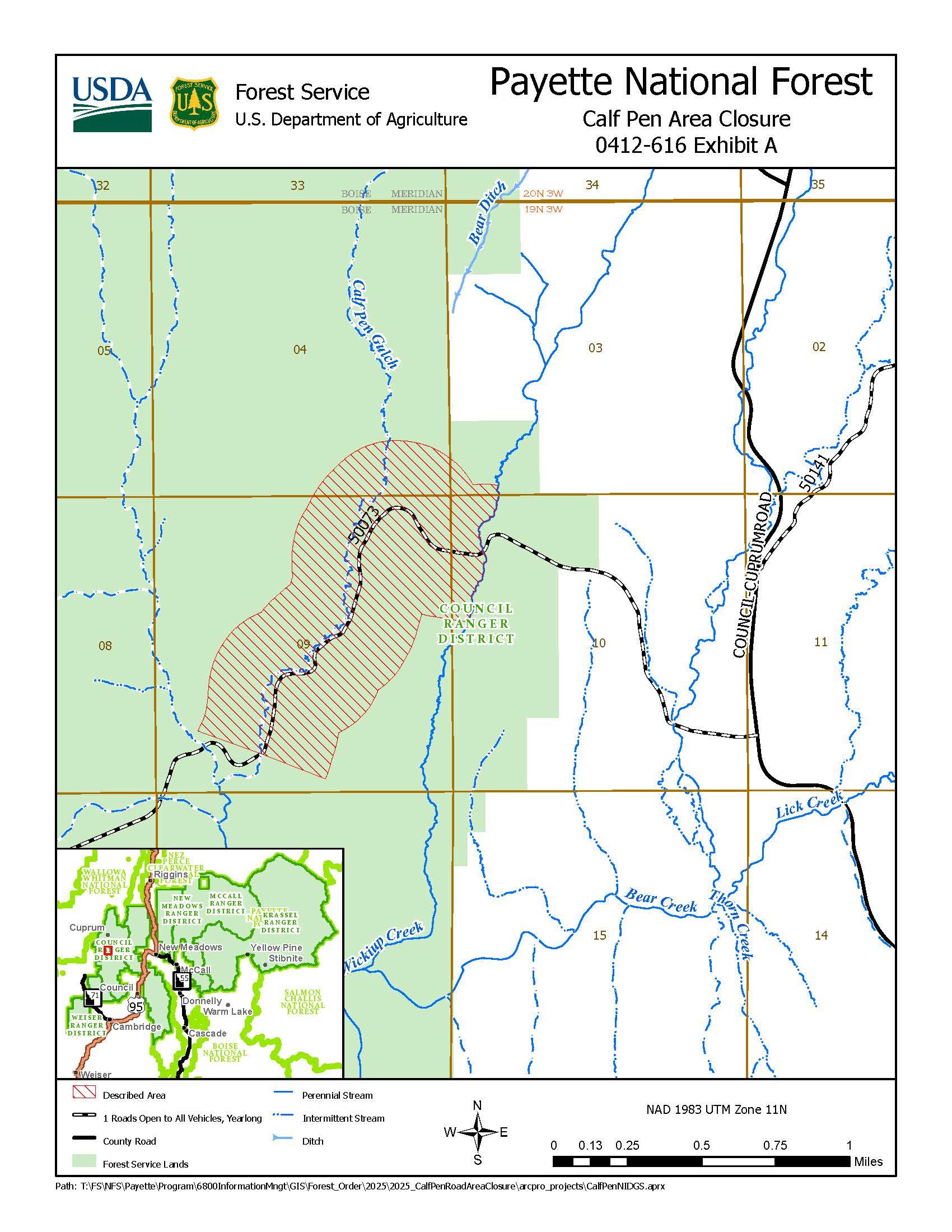
The Described Area is within Council Ranger District, Adams County, Idaho and Boise Meridian, and includes 1,200 feet of either side of (but excluding) NFS Road #50073 (Calf Pen Road) beginning where NFS Road #50073 crosses Wickiup Creek (T19N R3W NWNW Sec 10) and extending westerly for approximately 1.7 miles to where NFS Road 50073 crosses Calf Pen Gulch (T19N R3W SWSW Sec 9).
PURPOSE
The area adjacent to NFS Road #50073 has been identified as a sensitive area for a federally listed, threatened species.
IMPLEMENTATION
1. This Order shall be in effect from March 20, 2025 at 12:00 through March 20, 2030 at 24:00, unless rescinded.
2. A map identifying the Described Road and Trail is attached and made part of this Order as Exhibit A. For a digital version of this Order and Exhibit A, go to https://www.fs.usda.gov/r04/payette/alerts.
3. Unless otherwise expressly defined in this Order, the terms used in this Order are defined by the regulations of the Secretary of Agriculture, 36 C.F.R. Chapter II, Parts 200-299. If there are terms in this Order that are not expressly defined in the Order or 36 C.F.R. Chapter II, Parts 200-299, their meaning shall be determined by their plain language definitions.
4. A violation of the above prohibitions is punishable as a Class B misdemeanor by a fine of not more than $5,000 for individuals and $10,000 for organizations, or by imprisonment for not more than six months, or both. 16 U.S.C. § 551; 18 U.S.C. §§ 3559, 3571, and 3581.
5. Contact the Council Ranger District in Council, ID (208) 253-0100, and Payette National Forest Supervisor’s Office in McCall, ID (208) 634-0700, for more information about this Order.
6. This Order supersedes Order 0412-468 prohibiting the same or similar acts on the same Described Area.
Contact Number:
208-253-0100Maps
Images below will open full size in a new window.