
South Fork Coquille River
The 1,059 square-mile Coquille River Watershed is the third largest river system in Oregon to originate from the Coast Range.
The majority of the Coquille Watershed lies in Coos County, Oregon. The remainder is in Douglas County and a small area of Curry County.
The Coquille's three major tributaries--the North (including the East Fork), Middle, and South Forks--join the main stem within a few miles up- and downstream of the town of Myrtle Point and flow into the Pacific Ocean at Bandon.
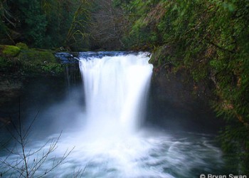
The South Fork Coquille River is a productive salmon and steelhead spawning stream. Coquille River winter steelhead can exceed 20 pounds and are famous for their acrobatics and strong fight! The river is not stocked for trout, but above Coquille River Falls, anglers can pursue wild cutthroat and rainbow trout. Below the Rogue River-Siskiyou National Forest boundary and the town of Powers, OR, there are several excellent drift boat floats for steelhead and Chinook salmon.
The river is closed to all angling between the RRSNF-private boundary and Coquille River Falls.
Getting There
Directions
From Medford, take I-5 North to exit 119 Winston. Take Highway 42 west toward Coquille. Take Highway 242 towards Powers. Drive through the town of Powers until the road turns into Forest Service Road 33. Coquille River Falls is about 12 miles south of the forest boundary.
Facility and Amenity Information
Restrooms
Restrooms are not available at this site.
Water
Potable water is not available at this site.