
Gold King Trailhead
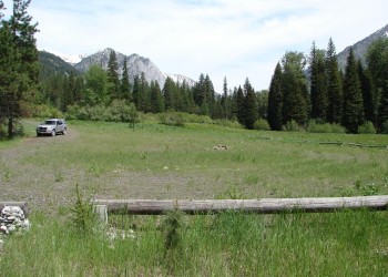
Gold King Trailhead is a small trailhead located in a picturesque meadow near East Eagle Creek. The site has a large gravel parking area for trucks and trailers and has picnic tables.
Visitors are asked to please respect private lands and roads in the area when using the trailhead or wilderness trails. Gold King Trail #1926 begins across the road northwest of the private land.
General Information
June
Open 24 hours/day
All visitors to the Eagle Cap Wilderness must obtain a Wilderness Visitor Permit before entering the area. Only one permit is required per group and there is no fee for the permits. Registration and Permit boxes are located at each trailhead near the information board. The permits are self-issued.
General rules of use and restrictions apply for this developed recreation site. Wilderness Regulations apply within Eagle Cap Wilderness.
- Motorized vehicles, bicycles, carts, hang glider and other mechanical equipment is prohibited in the Wilderness area.
No Fees are required for this site.
No fee required.
Getting There
Latitude / Longitude
Latitude: 45.028603
Longitude: -117.334144
Elevation
4330 feet
Directions
From Richland, Oregon head west on Highway 86 back towards Baker City for about 0.5 miles to the New Bridge County Road; Turn right on the New Bridge Road along Eagle Creek (road becomes Eagle Creek Road and Forest Road 7735) for about 13.5 miles (and going past Eagle Forks Campground) to Forest Road 7720; Turn slight right on Forest Road 7720 and go about 1.5 miles to Forest Road 77; Turn left on Forest Road 77 on go 10 miles to Forest Road 7745 (East Eagle Creek); Turn right Forest Road 7745 and go 4 miles. The trailhead entrance is on the right side of the road.
From Baker City, Oregon head north on Interstate 84 for about 1 mile to Highway 86 going towards Hells Canyon; Turn right onto Highway 86 and travel about 23 miles to Sparta Road; Turn left onto Sparta Road (also known as County Road 852) and go 5 miles to County Road 891 going toward Forshey Meadows; Turn left on County Road 891 and go about 5.5 miles (road becomes Forest Road 70) to Forest Road 7015; Turn right on Forest Road 7015 and go about 5 miles crossing over Eagle Creek at bridge; After crossing over bridge turn left on Forest Road 77; On Forest Road 77 go about 2.6 miles to Forest Road 7745 (East Eagle Creek); Turn right Forest Road 7745 and go 4 miles. The trailhead entrance is on the right side of the road.
Parking
5-6 trucks and trailers
Facility and Amenity Information
Accessibility
Restrooms
Restrooms are available at this site.
Water
Potable water is not available at this site.
Picnic Tables
Picnic tables are available at this site.
2 tables