-
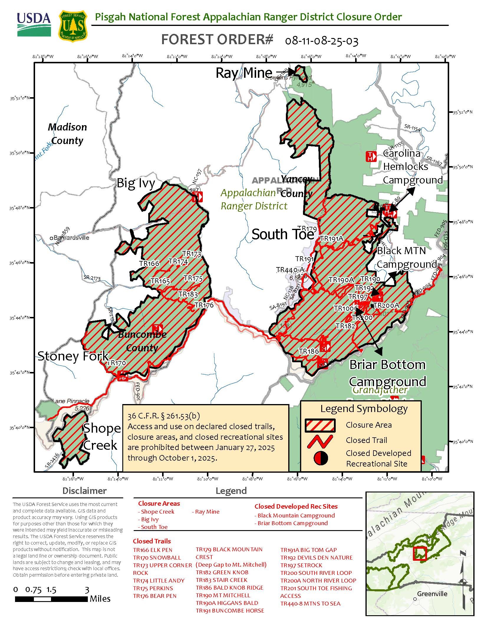
Appalachian Ranger District Hurricane Helene Updated Closures
The following recreation sites and trails remain closed to visitors:
Buncombe County: (Includes Big Ivy, Coleman Boundary, Shope Creek, Douglas Falls, Stony Fork)
- TR 174 Little Andy
- TR 173 Upper Corner Rock
- TR 166 Elk Pen
- TR 165 Walker Creek
- TR 175 Perkins
- TR 183 Staire Creek
- TR 176 Bear Pen
- TR 162 Douglas Falls
- TR 170 Snowball
- FSR 74 Big lvy
- FSR 231 Lower Staire
- FSR 63 Stoney Fork
- FSR 63A Hawksbill Creek
Haywood County (Includes Harmon Den Area)
- Haynes Road (Also Called Hurricane Creek)
- Buzzard Roost Road
- Old Buzzard Roost Road
Mitchell County (Includes the Roan Mountain Area)
- Poplar Boat Launch
Yancey County (Includes South Toe, Mount Mitchell)
- TR 179 Black Mountain Crest trail from Deep Gap to Mount Mitchell State Park
- TR 191A Big Tom Gap
- TR 190 Mt. Mitchell
- TR 190A Higgins Bald
- TR 197 Setrock
- TR 200 South River Loop
- TR 200A North River Loop
- TR 182 Green Knob
- TR 186 Bald Knob Ridge
- TR 1006 Briar Bottom Bike
- TR 201 S. Toe Fishing Access
- TR 192 Devil’s Den Nature
- FSR 472 South Toe River Road
- FSR 472F Black Mtn
- FSR 5544 Briar Bottom Group FSR 2074 Neals Creek
- FSR 5511 Seven Mile Ridge
- FSR 5500A Hunt Camp
- Black Mountain Campground
- Briar Bottom Campground
For the full press release visiting here.
Alert Start Date: May 23rd, 2025
Alert End Date: N/A
Order Number: 08-11-08-25-03
Associated Documents
Forest Order
Contact Name:
Appalachian Ranger DistrictContact Number:
(828) 689-9694Contact Email:
appalachianrd@usda.govMaps
Images below will open full size in a new window.