
Ground Detection Survey
Updated Dashboard
Standardized Ground Detections Surveys
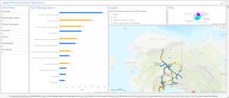
Screenshot of the Ground Detection Survey dashboard for Alaskan forest health observations.
Alaska Forest Health Protection (FHP) staff uses Esri® mobile applications to conduct annual ground detection surveys (GDS) for both detection and monitoring purposes. The primary goal is to standardize georeferenced forest health ground observations by using a mobile-friendly, form-based survey. The GDS includes more than 160 forest pathogens, insects, and non-infectious damage causing agents (DCA) known to occur in Alaska, as well as options to record symptoms with unknown DCA and negative data at locations that are monitored for change. Since 2020, FHP has implemented protocols to conduct two types of surveys that are nested within a single survey form, “Exploratory/Opportunistic observations” are used for casual, unplanned or spontaneous observations. “20-minute timed meander” surveys are scheduled and conducted at regular intervals along roads and trails with the goal of monitoring the same areas over time to record where DCAs both did and did not occur.
Cumulative ground observations are presented in the Alaska FHP Ground Detection Survey dashboard, which is available to the public and updated in near real-time. The dashboard is interactive, and records can be filtered by host, damage agent, survey year, and other attributes. The dashboard includes records collected with Survey123 for ArcGIS® (2015-present) and Collector for ArcGIS® (2013-2014) applications. It also includes records dating back to 1974 that were entered manually from annual forest health conditions reports, special surveys, and published literature. Data is also submitted to the national IDS database hosted by the Forest Health Assessment & Applied Science Team (FHAAST).
Survey Type (Required)
Selectable choice list: Exploratory/Opportunistic Observation or 20-Minute Timed-Meander
GPS Point (Required)
Automatically populated, optimal accuracy within 10 m.
Agent and Host
Damage Agent Category (Required to filter large DCA list)
Selectable choice list: Disease, Insect, Abiotic, Non-infectious or Unknown, or None (to record lack of damages for timed meanders)
Damage Causing Agent (Required core field)
Selectable choice list of 167 Alaska relevant damage causing agents (DCA). Selected choice automatically populates the core IDS field DCA_CODE from a lookup table of FHAAST DCA codes.
Host Tree or Host Tree Group (Required core fields)
Selectable choice list of 53 Alaska relevant hosts. Selected choice automatically populates the core IDS fields HOST_CODE and HOST_GROUP_CODE from a lookup table of FHAAST codes.
Size Class (Optional)
Selectable choice list of classification based on tree diameter: Seedling (<1” DBH), Sapling (1-5” DBH), Poletimber (5-10” DBH), Small sawtimber (10-15” DBH), Large sawtimber (>15” DBH), or Shrub. If more than one tree is affected, estimate the average stand diameter.
Damage Symptoms
First Damage Type (Required core field)
Selectable choice list of 33 symptoms seen on different tree parts (e.g., bark/cambium damage, bud damage, defoliation, crown dieback, decay, gall, open wound, etc.). First damage type should be the one with the most impact. Selected choice automatically populates the core IDS fields DAMAGE_TYPE_CODE from a lookup table of FHAAST codes. However, only 14 FHAAST damage type codes are available, therefore many records will use the code for “Other damage, known”. For example, the code for “Other damage, known” must be used for both canker diseases and bark beetles because there is no code for bark/cambium damage. IDS damage codes for defoliation are combined with severity, therefore it requires a manual cross-walk with the “Within Tree Damage Severity” field.
Second Damage Type (Optional)
Same choice list as above. Individual damage agents often cause more than one damage type, for example bud damage, which can lead to deformed growth and mortality.
Third Damage Type (Optional)
Same choice list as above. Individual damage agents often cause more than one damage type, for example bud damage, which can lead to deformed growth and mortality.
Damage Severity
Number of Damaged/Affected Trees (Required core field)
Selectable choice list of 5 classes for the number of affected trees: 1, 2-5, 6-15, 16-30, and >30. Automatically populates the IDS field NUMBER_OF_TREES_CODE.
Within Tree Damage Severity (Required)
Selectable choice list of 6 severity classes for first damage type: Trace to 5%, 6-35%, 36-50%, 51-67%, 68-75%, 75-100%. Severity assessment depends on the damage type selected. For defoliating agents, within tree severity is the percentage of leaves affected. For stem canker, severity is the percent of stem circumference affected. For bud blights, severity is the percent of buds affected. For evidence of decay on the tree bole or roots, the highest rating is assigned (75-100%).
Surrounding Forest Environment
Definitions and classes for land cover, forest type, and canopy cover were adopted from the Forest Inventory and Analysis Alaska program Field Manuals.
Land Cover (Optional)
Selectable choice list of 20 FIA descriptions of site cover such as: developed, forest, shrubland, herbaceous, planted, wetland, non-natural. Sub-categories further describe vegetation composition and structure.
Forest Type (Optional)
Selectable choice list of 16 FIA forest type classes defined as the species with the plurality of stocking for all live trees that are not overtopped (i.e., the dominant tree species).
Canopy Cover (Optional)
Selectable choice list of 5 FIA canopy cover classes: Closed forest (60-100% canopy cover), Open forest (25-60% canopy cover), Woodland (10-25% canopy cover), Scrub (at least 10% cover of dwarf trees less than 10 ft tall), Non-forest (less than 10% tree cover).
Diagnostics
Specimen Collected (Optional)
Yes/No choice list. If a sample is collected the sample ID is automatically created based on the date, time, and surveyor.
Photos (Required)
If damage is found, one photo is required to be used for identification or verification purposes. Multiple photos can be collected per record.
Comment (Optional)
Hidden fields
Other core fields specifically for IDS and automatically populated
SURVEY_YEAR, AREA, CREATED_DATE, MODIFIED_DATE, REGION_ID, US_AREA, IDS_DATA_SOURCE, ACRES
Other fields for IDS and automatically populated with special usage
NOTES (unique identifying number), PROJECT_NAME (GDS), PROJECT_LINK (website for project)
Automatically created by Survey123
CreationDate, Creator, EditDate, Editor, ObjectID, GlobalID.
Please cite “USDA Forest Service, Forest Health Protection and its partners” as the source of this data in maps and publications.
Data Disclaimer: The USDA Forest Service makes no warranty, expressed or implied, including the warranties of merchantability and fitness for a particular purpose, and assumes no legal liability or responsibility for the accuracy, reliability, completeness, or utility of these geospatial data, or for the improper or incorrect use of these geospatial data. These geospatial data and related maps or graphics are not legal documents and are not intended to be used as such. The data and maps may not be used to determine title, ownership, legal descriptions or boundaries, legal jurisdiction, or restrictions that may be in place on either public or private land. Natural hazards may or may not be depicted on the data and maps, and land users should exercise due caution. The data are dynamic and may change over time. The user is responsible to verify the limitations of the geospatial data and to use the data accordingly.
For more information, contact Dr. Lori Winton, R10 FHP Pathologist, loretta.winton@usda.gov; Garret Dubois, R10 Aerial Survey Program Manager, garret.d.dubois@usda.gov