
Epic Adventures
The Tongass abounds with special places, from bear viewing areas to migratory bird stopover sites, glaciers and misty fjords to limestone caves and karsts, and millions of acres of Wilderness. The chance to visit some of these special places is what draws more than 2.3 million people from around the world to visit the Tongass each year.
Water stored in glaciers creeps out to the sea. Water falls as rain and snow and feeds the temperate rainforest. Water carves the rocks and sheer cliffs. Water defines the Tongass National Forest.
At nearly 17-million-acres the Tongass is the largest national forest in the United States. It encompasses nearly 90 percent of the southeastern panhandle of Alaska. It stretches from the southern tip of Prince of Wales Island 500 miles north to the Hubbard Glacier just north of Yakutat. After crossing Dixon Entrance, a voyager traveling north on the waters of the Inside Passage is surrounded by the Tongass.
Though it is home to the largest intact temperate rainforest in the world, over half of the Tongass is covered by ice, water, muskeg, and rock. The islands and mainland create 11,000 miles of saltwater shoreline where regal mountains rise from tidewater to overlook a mostly undeveloped and isolated landscape.
A Varied Landscape
Few places in the world can boast of the geologic and climatic variations that characterize the Tongass. At sea level, rain, and lots of it falls throughout the year. Climb just 1,600 feet, and the climate is too harsh for trees. Lush temperate rainforest thrives at sea level, less than a two-mile hike from the frigid, windy alpine where buttercups and sedges cling to a tenuous existence.
"Rivers of ice," or glaciers, grind their way down from the mountaintops. While some glaciers remain perched above sea level, others, called "tidewater glaciers" deliver their icy cargo into the ocean. Even the face of the sea changes here as it surges through narrow channels and up glacier-carved fjords. Tides in Southeast Alaska, while not as severe as some of the tides further north, have a variation of as much as 25 feet in one 6-hour period. Tidal highs and lows alternate every 6.5 hours
Coastal Temperate Rainforest
Alaska’s National Forests harbor the largest remaining temperate rainforest in the world. The Tongass National Forest contains fourteen percent of the world total acreage of these productive forests. The forests of Prince William Sound on the Chugach National Forest represent the northernmost extent of this rich, but uncommon, ecosystem.
Coastal temperate rainforests are found in wet, cool climates where the collision of marine air and coastal mountains causes large amounts of rainfall. Rainfall in Southeast Alaska varies from two to 25 feet each year, depending on location. Coastal temperate rainforests extend from Kodiak Island along the coast to the California "fog belt" redwoods. Much of their remaining 75 to 100 million acres is found there and in Chile. Ecologists use four features to distinguish coastal rainforests from other temperate forest types: proximity to oceans, the presence of coastal mountains, cooler summer temperatures, and higher rainfall levels with significant precipitation occurring in all seasons. These unique conditions lead to vital links between the marine and terrestrial environments. The rainforest ecosystem does not end at the high tide line, rather, nutrients are cycled throughout the system.
Coastal temperate rainforests foster a hugely disproportionate share of the world biological production. They accumulate and store more organic matter than any other forest type (including tropical rainforests) as much as 1,000-2,000 metric tons of wood, foliage, leaf litter, moss, other living plants, and organic soil per acre. The adjacent waters are productive as well. Alaska temperate rainforests are comprised of thick stands of Sitka spruce, yellow cedar, redcedar, and western and mountain hemlock.
Unlike most places in the Lower 48, it is wind, and not fire, that disturbs the forests of the Tongass, sometimes toppling acres of trees at a time. In areas protected from the wind, usually on the north side of ridges, trees may live to be more than 500 years old. About 90 percent of these old growth forests remain as they were 100 years ago.
Unparalleled Wildlife
Each spring, the buzzy call of the varied thrush announces the arrival of warmer weather. It is joined by songbirds migrating their way north and others, such as the chestnut-backed chickadee and pine siskin, which make their homes here year-round. The largest known concentration of bald eagles gathers each fall and winter along the Chilkat River near Haines. Here, thousands of eagles feast on late runs of chum salmon. In spring, a eulachon (sea-run smelt) run lures hundreds of eagles to the Stikine River Delta near Wrangell. Within weeks, thousands of shorebirds stop on the delta to rest from their long trek north to summer breeding grounds.
Marine mammals are also abundant. Sea otters, seals, sea lions, porpoises and whales are often viewed throughout Southeast Alaska.
The Tongass is home to healthy populations of animals that have become uncommon in other areas of the United States. Biologists estimate that 1,700 coastal brown (grizzly) bears, the highest density in North America, roam Admiralty Island and share the island with large populations of nesting bald eagles. The Alexander Archipelago wolf is fairly common throughout much of Southeast Alaska. Mountain goats climb along steep, rocky crags above the timberline. In fact, there are no threatened or endangered species on the Tongass National Forest. Other animals such as moose, deer, beaver, fox and porcupine are common throughout the forest.
All five species of Pacific salmon (chum, coho, king, pink and sockeye) thrive and spawn in the streams and waters of the Tongass National Forest. Dolly Varden char, and rainbow, steelhead, and cutthroat trout are common freshwater fish.
A Working Forest That Provides
People have lived and worked in this water-drenched land for a multitude of centuries. For thousands of years the Tlingit and Haida peoples have pulled the salmon and herring out of these waters and gathered the berries and other land bounty. Each generation shares its knowledge of the land with the next. The Tsimshian moved from their former home in British Columbia to Annette Island in the late 1800’s.
Gold in this era drew thousands of fortune-seekers up though the Inside Passage to the towns of Douglas, Juneau and Skagway. As the gold potential dwindled in the 1900’s, communities built their economies around fishing, timber and then tourism. Past ways still flourish. Today, many rural residents depend on a subsistence lifestyle, just as Alaska Natives have for centuries.
A Forest for Visitors
The water routes are the gateway for Alaska visitors. Each year, nearly one million visitors travel through the Tongass National Forest aboard cruise ships or the Alaska Marine Highway ferries. Residents and tourists enjoy sailing, motor boating, kayaking and getting out on the water to fish.
The Mendenhall Glacier Visitor Center in Juneau is among the top three tourist attractions in the state. Visitors also travel to the Juneau Ice Field via helicopter and take organized boat trips into Misty Fiords and Tracy Arm. Ecotourism is one of the faster growing portions of the tourism industry.
Traveling through this watery world is a challenge. Roads between communities are rare. Only Hyder, Haines, and Skagway are connected to the North American road system. Roads connect many of the communities of Prince of Wales Island. The Alaska Marine Highway ferries, boats or large and small aircraft, are commonly used to get to communities throughout Southeast.
The changes in day length are far more pronounced here than in the Lower 48. Residents may see more than 17 hours of daylight in June. In winter, the daylight dwindles to just over seven hours at most.
The maritime environment dominates the weather. Normal summer highs average 55 to 60 degrees, with winter highs hovering around 30 to 35. Only rarely will the temperatures drop below zero. Average precipitation varies from 162 inches a year in Ketchikan to 26 inches a year in Skagway.
People from all over are passionate about the wet and enigmatic Tongass National Forest. Some say they want a sense that wild places remain where wildlife may roam undisturbed. Others defend the need to go to the woods and waters to make their living. With demands from all sides, the Forest Service works to balance the needs of people whose way of life is based in using resources while leaving large stretches of the ecosystem undisturbed for people who want to go to the woods for recreation and inspiration.
Facts & Figures
- The Tongass National Forest, at nearly 17 million acres, is twice the size of Maryland.
- Less than 8% of the Tongass is developed, primarily from past timber management activities.
- About 35% (6 million acres) of the Tongass is set aside as:
- 19 Congressionally designated Wilderness Areas
- 2 National Monuments
- 12 LUD (land use designation management)
- Another 43% of the Tongass is land use allocations that do not allow development activities.
- The remaining 22% is in land allocations that could allow development activities such as timber management.
- Timber management can occur on about 4% of the Tongass, which is located within this 22% of the forest where development could be allowed.
The sheer extent of Wilderness is one of the most defining features of the Tongass National Forest: at nearly 5,756,000 acres, 19 Wilderness Areas account for approximately one third of the forest. We have some of the highest qualities of wilderness character in the nation, such as outstanding opportunities for solitude and absence of development.
Due to the unique relationship of Tongass communities to the land and the area’s long history of subsistence—the harvest and use of natural resources for food, shelter, clothing, transportation, handicrafts, and trade—the Alaska National Interest Lands Conservation Act (ANILCA) allows for some continuing uses in Wilderness Areas. These uses include special access by motorboat and airplane, public use cabins, subsistence activities, and temporary facilities for hunting and fishing.
The magnificence and scenic beauty of wilderness landscapes, along with their values as intact ecosystems, make these areas important for local residents, visitors, recreationists, scientists, and researchers. The Tongass National Forest is committed to managing these areas for the use and enjoyment of future generations.
- Chuck River Wilderness
- Coronation Island and Warren Wilderness
- Endicott River Wilderness
- Karta River Wilderness
- Kootznoowoo Wilderness
- Maurelle Islands Wilderness
- Misty Fjords National Monument Wilderness
- Petersburg Creek - Duncan Salt Chuck Wilderness
- Pleasant - Lemesurier - Inian Islands Wilderness
- Russell Fjord Wilderness
- South Baranof Wilderness
- South Etolin Wilderness
- South Prince of Wales Wilderness
- Stikine - LeConte Wilderness
- Tebenkof Bay Wilderness and Kuiu Wilderness
- Tracy Arm - Fords Terror Wilderness
- 2019 Wilderness Best Management Practices for Tracy Arm-Fords Terror Wilderness - Agreement Regarding Vessel Operators
- West Chichagof - Yakobi Wilderness
- What Can I Do in Wilderness?
The 19 Wilderness Areas on the Tongass National Forest


The Tongass National Forest has the highest density of black bears in the world and one of the highest densities of brown bears. To provide visitors a safe place to view and photograph these iconic creatures in their natural habitats, the Tongass has five designated Bear Viewing Areas: Anan Creek, Dog Salmon Creek, Fish Creek, Margaret Creek, and Pack Creek. These are sites where bears congregate naturally when there are fish in the streams, and facilities have been built to make viewing the bears easier and safer, with minimum disturbance to the animals. In addition to black and brown bears, Bear Viewing Areas also can offer the opportunity to see salmon, bald eagles, sea lions, and other wildlife.
The Bears
The Tongass National Forest is home to both black bears (Ursus americanus) and brown bears (Ursus arctos). Brown bears (akin to "grizzlies" in the interior) are easily distinguished by a large hump of muscle over their shoulders as well as a dish-shaped face. Color is not a reliable way to determine species, as bears come in countless shades of brown, blonde, black, and cinnamon.
A typical bear's year begins in the spring when it emerges from hibernation. Adult males are the first to leave their den, sometimes as early as March. Females with cubs spend the most time hibernating, some not leaving until May.
While bears live throughout the Tongass and often gather around fish streams, the Forest Service maintains bear viewing facilities at Dog Salmon Creek (Prince of Wales Island), Fish Creek (Hyder), Margaret Creek (Ketchikan), Anan Creek (Wrangell), Pack Creek (Juneau), and Steep Creep (Mendenhall Glacier Visitor Center). You need a permit to go to Anan or Pack Creek.

Alaska has thousands of miles of beaches, but Yakutat has beaches that fascinate each and everyone who sees them for the first time. Sandy and very wide, the beaches seem to stretch east to west farther than the eye can see. Many people compare them to Oregon and California beaches.
Yakutat is near the midpoint of the 300 miles of sandy beaches that run from Cape Fairweather to Cape Suckling near Kayak Island. The beach is within five to ten miles of town and is easily accessible by old military roads built during the Second World War.
Residents use the beaches for recreation year-round. Sunny days bring picnickers, hikers, surfers and other recreational visitors to the shore. In August, they celebrate Fairweather Day at the beach. Notable waves lure body and board surfers to the area in increasing numbers.
The upper beaches of the Yakutat area are lined with tall spruce and hemlock trees with a remarkably straight boundary, looking almost like a giant hedge. In front of tree line are driftwood logs, fire weed, beach grass and strawberry patches.
Cannon Beach, a short drive from town, features World War II cannons and other paraphernalia of war rusting away within the tree line.
Continental ice sheets shaped the landscape of Southeastern Alaska over millions of years. The slow-moving ice carved deep fiords, sharpened mountain summits, and transported tons of sediment and debris onto the landscape. Large-scale deglaciation ended approximately 14,000 years ago and a barren landscape was left in its wake. The land once under ice became flooded with sea water within the steep valleys and trenches left after the last major ice retreat, eventually creating the Alexander Archipelago. Coastlines shifted due to more tectonic events, sea level changes worldwide, and isostatic rebound.
From this relatively bare and rugged landscape littered with glacial rubble and sediments, grew forested and non-forested habitats over thousands of years, evolving into the plant communities we see today. Depending on the substrate lichens, moss and fungi are usually the first to appear, followed by grasses, flowering plants, willows, alders, and conifer. Conifer forests generally formed on slopes that provide better soil drainage. Peatlands (muskegs) developed in more gently flat terrain where water accumulated, and decomposition rates were suppressed. Plants and animals (including salmon) recolonized into the region at various rates and from different places of origin, often independently of one another.
The present - day glaciers are fed from the moisture-laden Japanese current abruptly encountering the Coast Range and delivering high amounts of precipitation to the landscape. These glaciers in turn contribute massive amounts of freshwater to multiple glacial watersheds, which currently contribute approximately 30% of total freshwater discharge from Southeast Alaska. The glaciers we see today are not considered stagnant features. Many are still receding and losing mass balance at varying rates. Some retreating glaciers are exposing new land on an annual basis, providing opportunities for research on plant succession, hydrologic processes, or gaining new recreation opportunities and enhancing wildlife habitat. Glacier change can also be used as barometers of warming effects, and all are vulnerable to accelerated regional and global climate change. Multiple species of plants, birds and other animals use glacial habitats as home or feeding areas.
The history and diversity of glaciers on the Tongass are many, and so are the methods to experience them. Outfitter and guide services in local communities offer opportunities to explore glaciers by cruise ship, small boat, float plane, foot, kayak, skis, helicopter and even dogsled!
Glaciers on the Tongass
The massive Yakutat, Juneau, Stikine and Chickamin Ice Fields stretch across the crest of the Coast Mountains and the St Elias Range from Yakutat Bay to Misty Fiords. The rivers of ice they spawn are of interest to both scientists and visitors alike, and the Tongass National Forest offers many opportunities to get fairly close and personal with a glacier.
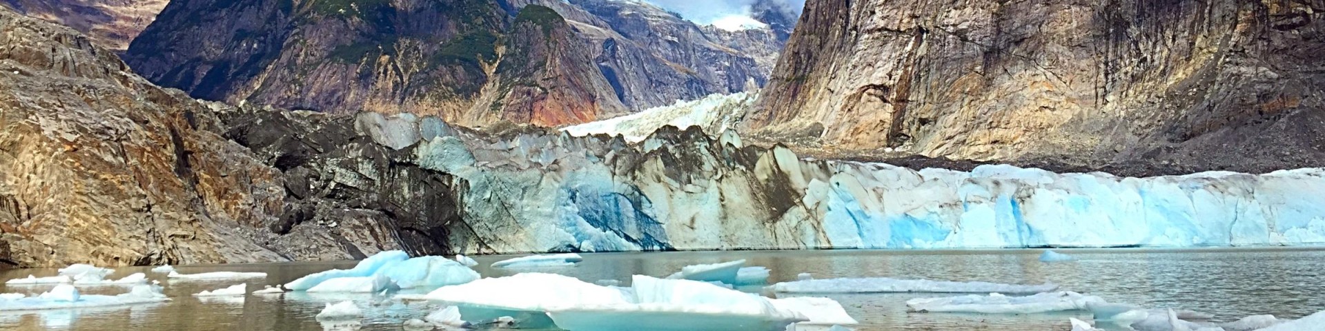
Many of Tongass glaciers empty into a glacial lake or a silty river flowing from under the ice that eventually reaches the sea. The large mainland rivers of the Tongass such as the Alsek, Taku, Stikine and Chickamin are fed by glaciers and adjacent icefields. Some of these glaciers require more planning to reach, as changing tides, boating long distances from communities and floating icebergs will slow you down, but it’s worth the effort! Ice breaking off from glaciers and crashing into the sea is called calving. Glaciers that calve directly into the sea are known as tidewater glaciers.
A boat ride from Wrangell or Petersburg can bring you close to the ice of LeConte Glacier, the southernmost tidewater glacier on the continent. LeConte Glacier and LeConte Bay reside in the Stikine-LeConte Wilderness. This glacier produces multiple calving events with numerous icebergs clogging the bay. These floating ice giants play host to harbor seals, especially during the pupping season in May and June. Petersburg High School students are monitoring glacier movement and thickness at the terminus, while university researchers are studying the interactions between the ocean and the glacier.
One glacier river that flows into a lake and eventually a river is the Mendenhall Glacier. It is the most accessible glacier to visit on the Tongass. It is located 13 miles from downtown Juneau along a paved road. The Mendenhall Glacier Visitor Center offers spectacular views of the glacier, floating icebergs, and the fantastic Juneau Icefield feeding it. There are additional trails in the Juneau area that lead to scenic views of Mendenhall and other glaciers.

Baird Glacier is approximately 20 miles NE from the town of Petersburg. In the past, it received a flow of visitors in spring because the glacier was resting on the terminal moraine, which is accessible by boat and hiking. Mountain climbers planning to ascend the infamous Devil’s Thumb would use this icy route to reach the base of the Thumb. Due to a large glacial lake outburst flood in 2015 (called a jökulhlaup) the terminus broke apart and retreated almost ½ mile, presently ending at the edge of a shallow lake, and no longer accessible by hiking from the moraine. However, this glacier has an outwash plain and terminal moraine still accessible by boat, and serves as the summer nesting and/or feeding grounds to many seabirds, including the Arctic Tern. Take a virtual trip to the Baird Glacier here.

Hubbard Glacier is located near Yakutat, Alaska and is the largest tidewater glacier in North America. In a region of retreating glacier, Hubbard Glacier's annual advances compared to those rapidly retreating makes it of great interest. the highest source of snow accumulation is at approximately 11,000 feet, traveling 76-miles towards the 6-mile wide terminus at sea level in Disenchantment Bay and Russel Fiord. The terminus reaches as height as 328-feet above sea level, equivalent to the height of a 30-story building.

Patterson Glacier near Petersburg, Alaska has receded so much in the last 20 years, the lake is now accessible via floatplane. the area near the glacier once supported an older forest that was wiped out during the Little Ice Age roughly 200 years ago. Remnants of this ancient forest remain in the area.
Shakes Glacier is in the Stikine LeConte Wilderness near the town of Wrangell. The glacier once reached the Stikine River in the late 1600’s and has been receding ever since, with a more rapid retreat since 1995. It can be visited via boat on the Stikine River to Shakes Lake. Wrangell High School students are studying this glacier.
