

Santee Research Data
Introduction
The Santee Experimental Forest provides a wide variety of field-scale and mesocosm-scale research facilities, instrumentation, laboratory and analytical capacity, and hydrological monitoring systems to support forest ecology, hydrology, soils and wildlife research. These facilities are available for use by agency scientists and their collaborators. The SEF also has trails for hiking and horseback riding, and most of the land is available for hunting.
More information can be found on the Santee EF website.
Data Description
Data from long-term monitoring and studies conducted on the Santee Experimental Forest are available. These data include hydrology and water quality measurements from four gauged watersheds, water table depth measurements within the gauged watersheds, climatic measurements from complete weather stations and satellite stations distributed across the Forest, and measurements of air quality and atmospheric deposition. Spatial data sets characterizing the vegatation, soil and water resources on the SEF are also available.
Queryable databases
- Headquarters
Database query tool
The collection of temperature and precipitation data at the Santee Headquarters began in January 1946. In 1996 additional measurements were included: wind speed and direction, solar radiation, net radiation, and relative humidity. From April 2008 to April 2012, minimum and maximum ozone measurements were also collected, and in September 2010, the collection of Pluvio National Atmospheric Deposition Program (NADP)-type rain gauge data began. The data available via this query database include data still being measured: 1996-present hourly Santee Headquarters weather station climate data, daily average temperature, and 15-minute Pluvio rain gage data. (The historical climate data and ozone data are available for download at http://doi.org/10.2737/RDS-2020-0070.)- View metadata
- Download metadata and fileindex (ZIP file)
- Watershed 77 2nd ed
Database query tool
Watershed 77 was established in 1963 to provide a site for research on understanding runoff and evapotranspiration processes and the water balance. Since then research has been conducted on the effects of management treatments such as thinning and prescribed burns (taking place since 1976) on the hydrology, water quality, carbon dynamics, soils and vegetation of low gradient, poorly drained forested watersheds in the SC Coastal Plain. This query database contains data starting in 2001.- View metadata
- Download metadata and fileindex (ZIP file)
- Watershed 78
Database query tool
Watershed 78 was established in 1964 to expand the scale at which research on the effects of watershed size on hydrologic relationships could be conducted on the Santee Experimental Forest. Monitoring on this watershed was discontinued in 1984 but resumed again in December 2004 as the USDA Forest Service initiated a multi-collaborative, multi-faceted research effort on the watershed. As part of this initiative, the US Geologic Survey (with support from the USDA Forest Service and the College of Charleston) installed instruments to monitor stage (for flow estimation) and rainfall at the watershed outlet at the Highway 41 N bridge over Turkey Creek in December 2004. At this time the USGS also began developing stage-discharge relationships for the Turkey Creek gauging station. The USDA Forest Service began monitoring water quality at the watershed outlet in March 2006 to coincide with ongoing monitoring of stream flow and climatic parameters.- View metadata
- Download metadata and fileindex (ZIP file)
- Watershed 79
Database query tool
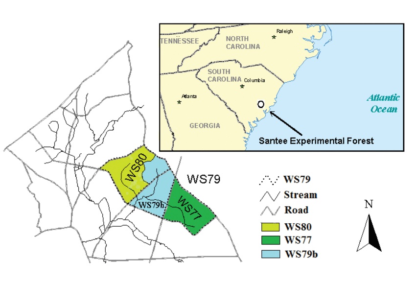
Streamflow and water chemistry data measured at Watershed 79 (WS79) on the Santee Experimental Forest near Huger, South Carolina starting in 1966. WS79 is a 500-hectare (ha) second-order watershed that was established in 1966 on the Santee Experimental Forest. It encompasses both of the paired first-order watersheds, Watershed 77 (WS77) and Watershed 80 (WS80).- View metadata
- Download metadata and fileindex (ZIP file)
- Watershed 80
Database query tool
Watershed 80 was established in 1968 to serve as a control site for research on the effects of management treatments (taking place since 1976 on Watershed 77, the treatment watershed) such as thinning and prescribed burns on the hydrology, water quality, soils, carbon dynamics and vegetation of low gradient, poorly drained forested watersheds in the SC Coastal Plain.- View metadata
- Download metadata and fileindex (ZIP file)
All data publications
Browse our full list of data publications.
If you have questions about these data or have conducted a research study on the Santee Experimental Forest and would like to make your dataset available for use by others, please contact .
Some supplemental data documentation available on this site may be provided in PDF or PDF/A format. Get the latest version of Adobe Acrobat Reader to interpret these files.