
Fire
Wildland Fire is a multifaceted, complex tool crucial for forest health and ensuring critical aspects of community safety. Maintaining healthy landscapes contributes to effective suppression efforts when Wildland Urban Interface (WUI) communities are unexpectedly threatened from unplanned ignitions.
Landscapes across the Northern Region (R1) consist of a highly diverse mix of land ownership and agency protection areas. Thus, the Northern Region takes a comprehensive approach to incorporating and managing Wildland Fire by working with tribal, state, local partners and other federal agencies. Building strong relationships with these entities is necessary to address land management issues across a diverse mix of land ownership and agency protection areas.
This cross-boundary approach allows for full regional implementation of the National Cohesive Wildland Fire Management Strategy and provides a solid framework upon which the Northern Region continuously evolves and improves this inclusive foundation.
Over the last few decades, the wildland fire management environment has significantly changed. A few examples of this change include:
- Longer fire seasons
- Larger fires
- More burned acres (on average) each year
- Fire managers observing more extreme fire behavior
Because of this, the Northern Region has incorporated data driven, scientifically informed decision making into every aspect of fuels management to best meet the goals of the Cohesive Strategy: resilient landscapes, fire adapted communities and safe and effective fire response.
Due in large part to the exclusion of fire for many decades, uncharacteristic and dangerous fuel loads have built up in much of the region over time. These fuel loads can produce uncontrollable fire behavior that can threaten communities, natural resources, and ecological and recreational values we hold dear.
Region 1 uses a combination of prescribed fire, mechanical treatments, and the effective management of some natural ignitions to reduce fuel loads, altering vegetation patterns in areas of strategic value in ways that reduce this risk. Our specialists also work closely with state, county and other partners to coordinate efforts and meet shared priorities that often extend past land boundaries.
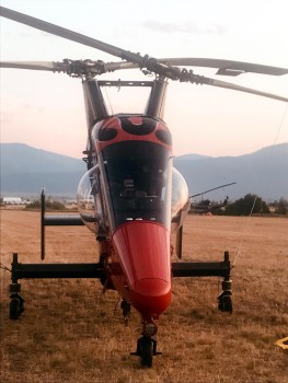
Kaman K-Max helicopters, with intermeshing rotors (synchropter) was used for operations on the Beescov Fire, 2019, Lolo National Forest.
(US Forest Service Photo.)Aviation encompasses a broad category of highly valuable Wildland Fire programmatic support areas and assets. These assets include various types of aircraft, both planes and helicopters . The Northern Region has been established as a leader within National Aviation Safety standards and consistently prioritizes operational safety throughout every aviation program component.
This program area provides regional support through multiple operations including suppression, aerial ignition, backcountry para-cargo, transportation, forest health, research. Forward-thinking programmatic innovations through implementation of new Unmanned Aircraft Systems program and peripheral technology delivery to include infra-red, LIDAR, timber scaling and survey, increases regional support capabilities.

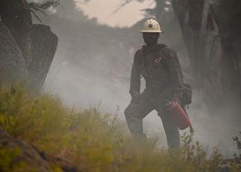
Torching trees during the Granite Pass Fire, August, 2021, Lolo National Forest.
The Northern Region Air Quality program uses appropriate air quality law, regulation, policies, and science to protect natural resources, including visibility, from adverse effects of human-caused air pollution. Air Resource Management supports wildland fire management activities by enhancing collaborative relationships and communication between regulatory agencies and Fire, Aviation and Air leaders.
The Northern Region Smoke Management program maintains collaborative relationships with our interagency partners and regulatory agencies including the Montana and Idaho Departments of Environmental Quality as well as the Environmental Protection Agency. Together, we all strive to balance the ecosystem’s need for fire with a mandate to protect public health and welfare.
Smoke Management
The Northern Region Smoke Management program maintains collaborative relationships with interagency partners and regulatory agencies by serving as an active member of the Montana Idaho Airshed Management Group MIAMG. Through this cooperation and use of the latest smoke modeling and weather forecasting techniques, the Northern Region strives to balance the ecosystem’s need for fire on the landscape with an obligation to comply with air quality regulations focused on protecting public health and welfare.
The National Wildlife Coordinating Group (NWCG) Smoke Management web site NWCG Emissions and Smoke Portal provides up-to-date information about many aspects of smoke management, including tools for managing smoke, state and federal regulations and policies, emissions, publications, training, and links to other valuable information.
Smoke Monitoring
The primary pollutant of concern from smoke is particulate matter, or more specifically, PM2.5 which are smoke particles smaller than 2.5 microns. PM2.5 can be respired (inhaled and exhaled) deeply into the lungs and can transport toxins directly into the blood stream. The United States Environmental Protection Agency (EPA) has established National Ambient Air Quality Standards for PM2.5 at 35 µg/m3 for a 24-hour average, and 15 µg/m3 for an annual average.
The Northern Region maintains a small cache of E-Sampler portable particulate monitors that are easily deployed to assess particulate levels resulting from wildland fire smoke. These monitors are also equipped with satellite uplink capabilities so the concentrations can be monitored in near real time over the internet. Nationally, the Forest Service also maintains a larger air monitoring cache if additional smoke monitors are needed.
Monitoring data can be viewed using the Fire and Smoke Map, a collaboration between AirNow and the Interagency Wildland Air Quality Response Program.

The Aerial Fire Depot (AFD) is a multifaceted wildland firefighting complex within a large, administrative site. The AFD provides a wide variety of regional support through various programs. There is an extensive maintenance program as well as continuing Capital Investment projects.
The Aerial Fire Depot has a Facility Base Manager who oversees the budget and maintenance for 115 acres, 21 buildings and an 8.74 acre aviation tarmac on the AFD campus. A few of the resources on base include:
- Missoula Air Tanker Base
- R-1 Aviation Hangar
- Northern Rockies Coordination Center
- Northern Rockies Training Center, including the Aerial Fire Depot Dormitory
- R-1 Fire Cache Warehouse
- Missoula Smokejumpers Loft / AFD Business Office
- Smokejumper Visitors Center
- Northern Rockies Learning Center / Daycare
Collaboration with other neighboring facilities is essential. Our partners include:
- Lolo National Forest
- National Oceanic and Atmospheric Administration’s Weather Service Station
- National Technology & Development Program
- Rocky Mountain Research Station / Fire Science Lab
- Missoula International Airport
The AFD Facilities Base Manager supervises and oversees Missoula Air Tanker Base Manager and personnel, and is therefore able to utilize Tanker Base staff to accomplish maintenance and repairs necessary for the campus which includes, but is not limited to:
- Snow removal
- Remodel/repair and maintenance
- Assist with security
- Contracting Officer Representative (COR) responsibilities

Service to the Line
Established in 1954, the Northern Rockies Cache supplies federal, state, tribal, and local government agencies within the Northern Rockies Geographical Area, an area that encompasses 235,600 square miles. The Cache is capable of immediately supplying up to 5,000 firefighters and more than 30 major wildland fires.
Contact Us:

Northern Rockies Cache
5765 W Broadway Street
Missoula, MT 59808
Main line: 406-329-4949
Duty phone: 406-210-0855
Fax: 406-329-4962
NRTC is an interagency Training Center serving the Northern Region and its federal, state and local cooperators. It is responsible for planning, coordinating and delivering leadership, fire, fuels and aviation training courses at the geographic area level (primarily 300 and 400 level courses).
We also provide coordination between the Northern Rockies/R1 and the National Training Centers. Staff consists of both Forest Service (FS) and Bureau of Indian Affairs (BIA) personnel. Other Agencies contribute funds on a proportional basis for their attending students and cadre supporting classes. NRTC has a staff of five (5) who support these efforts. NRTC is considered a leader of innovation in fire/fuels/incident management training delivery.
During fire season, NRTC provides support and assistance to our Northern Rockies Incident Management Teams (IMTs). One way NRTC provides support is through our Priority Trainee (PT) Program. The Priority Trainee Program was developed in 2015 and provides interagency trainees a method of priority trainee mobilization. Since this is recognized nationally, participants attain qualifications for interagency workforce development and to support IMT successional planning efforts. NRTC coordinates with all geographic areas to provide priority trainee opportunities as needed nationally.
NRCC is an interagency organization serving the 14 agencies of the Northern Rockies Coordinating Group and is one of ten coordination centers in the nation. NRCC’s mission is to provide safe, cost effective, and timely mobilization of resources and to promote efficient operations through interagency cooperation and standardized procedures.
NRCC accomplishes this through coordinating movement of emergency resources within the geographic area as well as between the Northern Rockies and the rest of the nation. NRCC provides for coordination and management of the area’s Incident Management Teams while utilizing utilizes and assisting with software applications such as Incident Ordering Resource Capabilities (IROC), 209s and Situation Reporting.
In addition, NRCC leads the Geographic Area in coordination system issues. The six agencies who staff the office include:
- Forest Service
- Bureau of Land Management
- US Fish and Wildlife Service
- Bureau of Indian Affairs
- National Park Service
- Montana Department of Natural Resources and Conservation
Idaho Department of Lands is a financial contributor. These agencies share costs on a proportional basis with a typical staff of 12 full time employees.

A West Yellowstone Smokejumper descends through the sky during a spring training jump. Custer Gallatin National Forest. West Yellowstone Smokejumpers train in May and early June for the upcoming fire season.
(USDA Forest Service Photo / Samsara Chapman Duffey.)The Smokejumper Program provides a highly skilled, rapid response and operationally focused fire resource, which primarily provides initial attack suppression on emerging fires.
Smokejumpers fill a variety of leadership roles on emerging, complex, urban interfaces, and long duration incidents. Their training, versatility, and agility enable them to provide leadership that can establish command structure, situational assessment, and both tactical and logistical support for extended fire and all risk operations.
The Missoula Smokejumper Base employs 75 smokejumpers, providing a rapid response workforce to assist forest and program managers regionally and nationally. Smokejumpers provide support and leadership to prescribed fire programs, thinning and timber stand improvement projects, hazard tree removal, trails and recreation projects, and cargo delivery via both traditional and GPS guided parachutes.
Smokejumpers manage regional programs including the Region 1 (R1) para-cargo program, R1 Lead Forward Veterans hiring program, Region 8 (R8) Prescribed Fire Module Coordination, the Northern Region University (NRU), and R1 Fireline Explosives (FLE) program.
National program support provided by Smokejumpers includes the Disaster Assistance Support Program (DASP), Forest Service International Programs (IP), Primary Leader Academy (PLA), and the Wildland Firefighter Apprenticeship Program (WFAP).
Smokejumper's service is built upon the foundation of close working partnerships with smokejumper program users and cooperators and is based on the core values of safety, professionalism, and flexibility.
West Yellowstone, Montana and Grangeville, Idaho are the homes of the other two Northern Region smokejumper bases. The Northern Region is home to three of the seven Forest Service jump bases nationwide.

CL-415EAF super scooper filling on the lake during the Colt Fire, July 22, 2023. Lolo National Forest.
(USDA Forest Service photo. )Missoula Air Tanker Base personnel ensure safe ground operations and movement of all fixed wing aircraft, which include:
- Large Air Tankers
- Single Engine Air Tankers
- Smokejumper Aircraft
- Air Attack
- Lead Planes
- Other miscellaneous fixed wing aircraft
Air Tanker Base personnel also serve as ACOR’s for smokejumper aircraft. Missoula tanker base staff safely marshal and park fixed wing aircraft, mix retardant, and load with retardant all air tankers.
Air Tanker Base personnel manifest, load and unload contract 727 Aircraft Flights with wildland firefighting personnel mobilized out of R1 or arrive in R1. Tanker base staff also utilize their IQCS Red Card qualifications to assist other aviation units and incidents regionally, nationally, and internationally.
Many Thanks to to Mr. Ray Kresek for allowing us to re-print this article. Please visit the Fire Lookout Museum at 123 W. Westview in Spokane, Washington, 99218, or phone (509) 466-9171; or visit their web site at Fire Lookouts of the Northwest.
The Osborne Firefinder
by Ray Kresek
William Bushnell "Bush" Osborne, Jr., as a young graduate forester, went to work for the U.S. Forest Service in 1909 on the Oregon National Forest at Mount Hood.
In 1911 he invented an alidade he called the "firefinder" and tested in 8 locations in Oregon and SW Washington. The original instrument was 14" across, round, with a map of the surrounding area, and each of 360 degrees etched around the rim. This disc was secured to an 8-sided 1/8" steel base which was in turn secured firmly to a tree stump. A brass sighting mechanism consisting of a rear vertical slit and a front vertical horsehair stretched tight, pivoted precisely in the center of the circle. The location of the lookout point was situated exactly in the center of the circular map. An arrow etched beneath the rear sight corresponded with the compass reading when the sights lined up on distant smoke.
This first Osborne Firefinder was commercially produced in 1913 by Fred Leupold and Adam Volpel (Leupold-Volpel & Co.) at their scientific instrument manufacturing facility in Portland (Oregon). The U.S. Forest Service purchased fewer than 100 of these 1913 Model Osborne firefinders.
In 1914 the center-pivot sighting mechanism was abandoned in favor of a circular outer ring with the original fore and aft sights affixed to it. A cast iron base with a round recessed rim permitted the sights to be moved freely around the rim. Zero degrees was positioned true S[outh] from the lookout location. To prove this instrument, "Bush" Osborne placed it atop Mount Hood the following summer. In one month, lookout Elijah "Lige" Coalman spotted and reported 131 fires with this instrument!
In 1915, Osborne again modified his "firefinder" sighting mechanism. The 1915 model featured a 0-power scope similar to those used on a rifle, instead of the original fore and aft upright sights, to peer through. Precision calibration permitted obtaining azimuth readings to 1/60th of 1 degree; and a vertical angle reading in 1/10th of 1 degree accuracy. Several hundred of the 1915 Osborne Firefinders were produced by Leupold-Volpel Co.
In 1917, Bush Osborne again gave his Firefinder a radical change. Its width was enlarged from 14' to 24" across. Its weight was increased from 10 to 70 pounds, including the 3-railed track it sat upon. It featured rugged alidade sights front and back, using the concept of the 1913-1914 models; however, the front sight is equipped with a thin brass tape which could be moved up and down freely with a thumb wheel. As this wheel was turned back and forth while the observer sighted through the rear sight slot at the distant topography, a pencil attached to a sliding gear-driven arm could draw the panoramic features of the horizon. Thus, a panoramic picture could be drawn to accompany "seen area" maps made by the firewatcher. About a hundred 1917 Osborne Firefinders were manufactured.
In 1934, Osborne again radically changed only the sighting assembly, to include a far simpler mechanism. The rear sight now included "+" (plus) and "-" (minus) vertical scales and two sets of cross threads of horsehair, so that accurate vertical readings could be made on fires both below and above the lookout's elevation. Leupold-Volpel Co. manufactured more than three thousand of the lighter weight 55-pound 1934 Osborne Firefinders, until it ceased to produce the instrument in 1989.
For a time prior to that, the A. Lietz Co. of San Francisco also manufactured the Osborne Firefinder in small quantities. The 1934 Osborne Firefinder is the most widely used fire plotting instrument in the world today. It is used across America, and in many foreign nations on at least four continents. They were last featured for sale in the 1991 Forestry Suppliers catalog for $3,495 each.
Alidade: 1. An indicator or sighting apparatus on a plane table, used in angular measurement. 2. A topographic surveying and mapping instrument with a telescope and graduated vertical circle.
Azimuth: 1. The horizontal angular distance from a fixed reference direction to a position, object, or object referent, as to a great circle intersecting a celestial body, usually measured clockwise in degrees along the horizon from a point due south.
InciWeb

InciWeb is an interagency, all-risk incident information system that provides a single source of information for the public and media about wildfires, prescribed burns, and other incidents, including natural disasters.
NIFC - National Interagency Fire Center
NIFC is the nation's logistical and support center for wildland fire and other emergency situations, coordinating the mobilization of resources and providing support to agencies fighting wildfires and other incidents across the United States.
Careers in Wildland Fire
Challenge yourself to new limits, join the Forest Service crews who serve to protect millions of acres within our national forests, our communities, and our natural resources.