

Observation Point Campground
The campground is a rustic high elevation campground just off the Magruder Corridor Road # 468. Chuckling Creek meanders through the campground. Whitebark pine, subalpine fir and lodgepole pine dominate the overstory vegetation. Deer, elk and other wildlife frequent the area. There is an observation point to look out on the expanse of the Frank Church River of No Return Wilderness area. The campground contains 5 primitive campsites and no picnic tables. There is a vault toilet onsite.
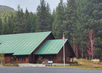
Observation Point Campground
Observation Point Campground sites and creek.


General Information
The area has a history of wildland fire activity. Recent and long-ago areas have burned along this high elevation corridor. Though no trailheads take off from the campground, there are trailheads both north and south of the campground which offer backcountry wilderness hikes.
July through September, or until closed by snow.
24 hours / 7 days week
Campfires allowed, dependent upon seasonal fire restrictions.
Pets must be leashed or under physical control.
Practice Leave No Trace principles when visiting forest lands.
Pack it in, Pack it out, no garbage service provided.
Quiet Hours are from 10:00 pm to 6:00am
Weed Seed Free feed is required on all national forest land: Weed Free Forage & Mulch Products Regional Order
Camping is limited to 14 consecutive days: Camping Restrictions Regional Order
No fees are required for this site
No Fees
Pets must be leashed.
Contact Name: West Fork Ranger District
Contact Phone: 406-821-3269
Address: 6735 West Fork Road Darby, MT 59829
Phone: 406-821-3269
Hours: Monday-Friday, 8:00 a.m. - 4:30 p.m. (Closed on federal holidays)
Getting There
Latitude / Longitude
Latitude: 45.66583333
Longitude: -114.8086111
Elevation
7650'
Directions
From Darby, MT travel south 4.3 miles on Highway 93, turn south on the West Fork Road and proceed for approximately 14.3 miles. Turn west (right) on Forest Road 468, Nez Perce Road and travel for approximately 35 miles (Nez Perce Rd becomes Magruder Corridor). Turn west (left) at Magruder Corridor Nez Perce Trail Rd. # 468 junction with Forest Road # 6223 and continue a steep narrow uphill grade for 9 miles to Observation Point Campground.
Travel Considerations
A high clearance vehicle is recommended. Trailers over 16 feet are not recommended on this section of the road. The gravel road is very narrow and rough. Consider taking a saw as trees frequently fall across the road.
Facility and Amenity Information
Accessibility
Restroom is accessible from the Forest Road # 468.
Restrooms
Restrooms are not available at this site.
Water
Potable water is not available at this site.
Picnic Tables
Picnic tables are not available at this site.