





Forest Divide Trail # 710
The Forest Divide trail is 2.5 miles long. It begins at Nezperce National Forest Trail 520 and ends at Trail 52. The trail is open for the following uses: Horseback Riding, Hiking
Specific Trail Information
Trail Number
Trail Type
General Information
This Trail is entirely located in the Selway Bitterroot Wilderness area.
Stock users must use: certified weed seed free feed
Camping is limited to 16 consecutive days.
Practice Leave No Trace principles when visiting forest lands.
Pack it in, Pack it out, no garbage service provided.
Campfires allowed, dependent upon any fire restrictions.
Practice good trail etiquette.
For the recent trail clearing status:
Interactive Trail Clearing Status Map
Bitterroot National Forest Visitor Use Map - South Half:
The trail is typically available from May 15 through November.
No permits required for non-commercial use.
Water is available from natural sources. No potable water available.
No motorized equipment: (chainsaws).
No mechanized equipment: (vehicles, OHV, motorcycles, bikes, drones, gliders, aircraft landings)
Max group size: 20 people and 20 stock animals
Contact Name: West Fork Ranger District
Contact Phone: 406-821-3269
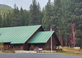
Address: 6735 West Fork Road Darby, MT 59829
Phone: 406-821-3269
Hours: Monday-Friday, 8:00 a.m. - 4:30 p.m. (Closed on federal holidays)
Getting There
Parking
This trail is entirely located in the Selway Bitterroot Wilderness area. Parking is located at Paradise.


