
History of the Rio Grande
The Rio Grande National Forest covers a vast area of Southwestern Colorado. Learn more about the history of this area from early indigenous use to the formation of the forest, from the early timber mills and mining towns to transportation.
Predating the formation of the Rio Grande National Forest (RGNF) in 1908 an Act of Congress, dated March 3, 1891, authorized the President to establish reservations of timber lands. A growing concern by the public and newly formed forestry groups for conservation of timber resources supported this authorization. The concern included watershed protection and maintaining the forests for recreational purposes.
Public sentiment pertaining to formation of the original Forest Reserves was varied. Generally, the local communities were in favor of the reserves. Farmers wanted protection of the watershed from fire to ensure water for irrigation, miners wanted a continuous supply of timber for their mines, and cattleman wanted the reserves to protect their ranges from overuse by sheep. In general local business people were in favor whatever was good for the general welfare of the community.
Sheep herders opposed the formation of the reserves because they felt that, possibly, the summer range would become closed to sheep grazing altogether. Lumbermen were also worried about restrictions on cutting, although some realized the benefit in the long run.
The RGNF was officially created on July 1, 1908 by Theodore Roosevelt in Executive Order Number 887. It was formed by combining 1,102,798 acres from the existing San Juan National Forest and 159,360 acres from the existing Cochetopa National Forest, for a total of 1,262,158 acres. This original area was within the Rio Grande drainage, excluding the Saguache and Carnero Creek drainages. In 1944 the west side of the Sangre de Cristo range and the Saguache Creek area were added, while the Mount Blanca area became an addition in 1954. Total land area within the RGNF is now 1.84, million acres.
The Rio Grande National Forest currently has three Ranger Districts, the Saguache Ranger District to the north, the central Divide Ranger District, and to the south, the Conejos Peak District. Since the forest’s formation there were changes to how the forest was divided and managed.
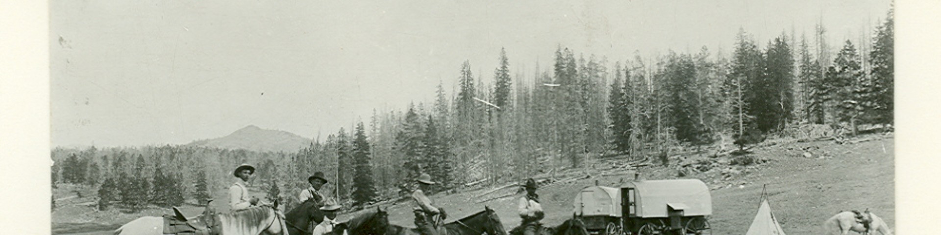
The area comprising the San Luis Valley and Rio Grande National Forest has a rich and colorful history.
Native American Paleo-Indian cultures, beginning with the Clovis and Folsom Complexes (11,000 years ago) were the first know inhabitants of the area. These and the following cultures of the Archaic Stage and the Ute Indians lived by hunting animals and gathering native plants found in the area. The San Luis Valley and surrounding mountains are the homeland of multiple tribes including the Ute Mountain Ute Tribe of the Ute Nation of Indians, Pueblo, Navaho, and Apache.
The Spanish began exploring the San Luis area during the late 1500’s. In an attempt to get people to settle the area, Mexico established numerous land grants within the Spanish territory.
The valley remained largely unsettled until the area became the territory of the United States around 1850.
The first permanent settlement in Colorado, known as San Luis de la Culebra, was established in 1851 on the Rio Culebra River on the Sangre de Cristo Grant. To protect the early settlers in the valley, Fort Massachusetts was established, north of San Luis, in 1852. La Loma de San Jose, near present Del Norte, was first inhabited by Hispanic families in 1859 that left the Santa Fe area. Irrigation ditches were constructed, and farms established. More extensive farming activities began in the 1880s near Hooper and the area near Monte Vista where large-scale irrigation systems were built.
Gold and silver were discovered near Summitville in 1870 which began the mining rush to the area. Other mining settlements followed at Bonanza, Creede, and along the Sangre de Cristo Mountains. Del Norte, one of Colorado’s earliest cities, established in 1872, served as a supply point and gateway to the San Juan mining camps.
In 1891, an Act of Congress authorized the establishment of Timber Reserves in order to conserve the nation’s timber, range and water resources. Portions of these established reserves were combined to form the Rio Grande National Forest in 1908.
Written historical references to the Conejos River valley during the time before the 1600’s are few, but evidence of Paleo-Indians, and later cultures and tribes lies scattered throughout region. Archaeological artifacts an indigenous knowledge indicate that these lands were inhabited for thousands of years before the appearance of Europeans.
The San Luis Valley and surrounding mountains is homeland of the Ute Mountain Ute Tribe of the Ute Nation of Indians. The Ute Mountain Ute Tribe are the Weminuche band of the Ute Nation of Indians.
This area is also homeland to the Navajo, Apache, and Comanche, who used it for hunting, gathering, and trading. The nomadic lifestyle of the Utes and their visitors left little evidence of their traditional, seasonal camps. However, the extensive distribution of campsites, arrowheads, stone chips, and other artifacts as well as Indigenous knowledge attest to centuries of living.
The Ute Indians are distinguished by the Ute language, which is Shoshonean, a branch of the UtoAztecan linguistic stock (Garcia and Tripp, 1977). Other Indians in the United States that speak Shoshonean are the Paiute, Goshute, Shoshone, and several California Tribes.
The Weminuche Band inhabited the land along the western flank of the Rocky Mountains in the area of the present states of Utah, Colorado, Arizona, and New Mexico. Weminuche homelands included all the lands that they normally protected and regularly traveled through. Weminuche lands extended north of the San Juan River in what is now New Mexico and Utah to the San Miguel River in Colorado and the La Sal Mountains in Utah (Ute Mountain Ute Tribe, 1985). The Continental Divide bounded their eastern range, and the Abajo Mountains in Utah marked their western boundary. These lines were vague in definite limits and bands of Utes and other tribes shared border areas. Ancestors of the Allen Canyon White Mesa Utes and Paiutes lived in the western part of Weminuche territory in what is now eastern Utah and Arizona. ( Source: Ute Mountain Ute Tribe)
Many people traveled and lived on these lands over thousands of years. In some areas trade and travel routes are still followed. One of the heaviest used trails by indigenous peoples passed between the Chama River Valley in New Mexico over Cumbres pass, along a route similar to that taken today by Highway 17. From Cumbres pass, the trail descended along La Manga Creek to the foothills bordering the San Luis Valley.
Please remember that both Forest Service Policy and federal law state that it is illegal to remove any artifact 50 years-old or older from public lands (36 CFR 800, Title 18: Theft and Destruction of Government Property, the 1906 Antiquities Act, and the National Historic Preservation Act (NHPA) of 1966). An artifact is defined as “anything that is or was made or used by people”. When in doubt about its age; please leave it where it lies and take a photo! Section 6(d) of the Archaeological Resources Protection Act (ARPA) also aids law enforcement in levying fines, and even imprisonment for the removal or destruction of archaeological materials. Removing artifacts is stealing and/or erasing knowledge and cultural heritage from posterity and the American public. Please, if you find something, share the data you collect with the Archaeologists on the Rio Grande NF.
If you come across, an arrowhead or pottery sherd, please do not collect it but take a picture and a GPS location (we call this “catch and release”). If the artifact is in harm’s way (i.e. in a trail or a road), please move it to the side in a more protected area, as it probably eroded from somewhere nearby into the trail/road in the first place. Then please notify Price Heiner, Forest Archaeologist/Heritage Program Manager 719.480.1105 or price.heiner@usda.gov.
Resources for Indigenous History:
The vast San Luis was once a northern frontier of the Spanish Empire. During the 17th and 18th centuries, occasional expeditions came from Santa Fe to the valley and surrounding mountains in exploration parties on military campaigns, and to trade. One of the most noteworthy expeditions was that of the Governor General Don Diego de Vargas, which passed through the area in 1694. Almost a century later, in the summer of 1779, Governor Baustista de Anza and his army of 600 met their Ute and Apache allies on the Conejos River to proceed north on a campaign against the Comanche. This north-south route continued to be used by Spanish, French, Anglo trappers, traders, and then by settlers traveling between the present day New Mexico and Colorado.
In the winter of 1807, Captain Zebulon Pike and a small contingent of men were exploring the newly acquired “Louisiana Purchase” and arrived in the San Luis Valley. They build a small shelter on the Conejos River, six miles upstream from its confluence with the Rio Grande, in what was then Spanish territory. The Colorado State Historical Society has erected a dramatic log stockade on the site in commemoration of the event.
Later in 1848, General John C. Fremont made a disastrous attempt to cross the San Juan Mountains in the dead of winter in an attempt to locate a route for the railroad. Their route would be nearly impassible in a normal winter, and the winter of 1848 was particularly harsh, with 6-7 foot drifts in the mountains. Eleven of the 37 men and all of the 120 mules died on the trip.
The Conejos River drainage basin and the San Luis Valley have a long and colorful history. The history of the Conejos Peak Ranger District is interwoven with that of the San Luis Valley because the people setting in the valley depended upon the surrounding mountains for much of their food, clothing, and shelter. Seeking out the many historic features that lie scattered over the District and adjacent land can be an exciting and enjoyable activity, lending an understanding of the area’s rich cultural background. Some of the most notable historic sites are Colorado’s oldest church in the town of Conejos, a stockade commemorating the Zebulon pike expedition, and Toltec Scenic Railroad. Favorite routes for history study are Forest Road 240 towards, Platoro, the Osier Mountain road (Forest Road 103), and the scenic railroad.
TERRACE RESERVOIR
This is Alamosa River backed up three-and –a-half miles in storage. This earthen dam, built during the years around 1906, at that time was the largest dam of that sort in the U.S., was constructed by the old, hard way—men, dynamite, mules, horses, picks, shovels, scrapers, fresnos, and wagons. Back in 1878, the soldiers of Fort Garland built a wagon road from Fort Garland to Fort Lewis at Pagosa Springs, going up the Alamosa Canyon, over Elwood Pass to the Continental Divide. That road and a village, Cockrell, were covered by the waters of the dam.
THE ALAMOSA CANYON AND THE SOUTH SAN JUAN MOUNTAINS
The Alamosa River is the key to understanding this area of the Rio Grande National Forest. Its geological story is clear; its history rich, branching out to other mountains and valleys. As a natural route up and over the Continental Divide, it has been an ancient trail; a “road to the California gold fields”; a U.S. Army wagon road; the miners’ freighting road; in 1910 a, transcontinental telephone route; in 1911, a proposed transcontinental road. There are no fish in the Alamosa River here, but people like the beautiful Alamosa Canyon. There are summer camps. Phillips University of Enid, Oklahoma has had since 1950, study-camp here with courses in geology, biology and art. There is a National Forest (Alamosa) campground and the Sacred Heart Youth Camp of Alamosa City. Cattle ranches have been here since after the Civil War. SILVER LAKES TURNOFF An old toll road left the Alamosa Rier goes up and over Cornwall Mountain to the mines in the Conejos River Valley and Platoro. Gold and silver ore and miners’ supplies were hauled over it. This route is still used by the cattle from the Gunbarrel Ranches to drive to summer pasture on the Conejos. The top of Cornwall Mountain (Hinsdale basalt) is dotted with glacial lakes created during the last ice age. ALAMOSA GUARD STATION Alamosa Guard Station was built in 1908, the year the Rio Grande Forest was established. Its logs were cut near the site and hand hewn. It was home and District headquarters from 1908 to 1948, with garage, workshop, saddle shed, and bunkhouse. Today it is used by Forest Service crews as a work center.
GOVERNMENT PARK
An old map of 1880 locates “Government Agency” in this park probably a supply base and shelter for the men of Fort Garland building the wagon road to Elwood pass and Pagosa Springs. Was it a tent or cabin outpost? So far no one knows. Although the Army ordered a survey for the road, none seems to have been made. Actually, there was only one best way—the indigenous trail to the famous healing hot springs at Pagosa, a natural route used for centuries. MINING COUNTRY Jasper – Cornwall District boomed in 1874 after discovery of gold at Summitville brought prospectors to the area. Jasper mines were close to town. Among mines on this side of the river were the Rosie S., the Jessie S., Lulu, Buckeye, and the I-Don’t-Care. Across the river on Cornwall Mountain were the Perry, the Miser, Guadalupe, Tinware, Adams, Sickles, the Clara, the Ella, Tip Top, and Tidal Wave. A few of the old Jasper log houses survive as summer homes today. Here and there in the woods other old cabins are slowly returning to the earth they grew from as trees 100 years ago.
BLOWOUT PASS
Over this hair-raiser trail, the gold and silver ores from the mines of Jasper-Cornwall District, Stunner, and Platoro were packed out by burro trains. The trains descended a creek on the north side, still called Burro Creek to Los Pinos (The Pines) into Del Norte. Then from Del Norte, wagons carried the ore to Canon City on the Arkansas River and the new railroad carried it east.
WIGHTMAN FORK
This stream is well named. In 1870, James Wightman and four friends prospected up to the headwaters of this wild mountain cataract and by their finds started the gold rush to the mountain near its source, to become the famous Summitville, the highest mining camp in the State of Colorado.
BITTER CREEK AND ALUM CREEK
Bitter Creek and Alum Creek are highly toxic unusable because of acidity and high mineral content—silicon dioxide, ferric, oxide, aluminum oxide, calcium oxide, magnesium oxide and sulfur trioxide. The boulders, banks, and even the bridges of these creeks after heavy rains above and resulting high water, are coated with a yellowish cement-like wash, limonite. Numerous tributaries contribute significant levels of pollution to the Alamosa River. This pollution prevents the river from supporting a diverse aquatic ecosystem. Sources of this pollution are primarily natural mineral outcrops on Lookout Mountain and its two adjacent peaks.
STUNNER
Stunner was never very big but has long been a ghost town with ghost mines on both sides of the Alamosa River. The names of its mines have a special flavor—the Orpheus, Cornucopia, the Merrimac, Log Cabin, and Snow Storm, and as always, a mine for a wife, daughter, or sweetheart, the Louise. Only those mines north of the river shipped payable ore; those south shipped no ore. Stunner, like the Platoro camp south across the mountain to the left, had transportation problems. The government road had washed out by 1885 and was not repaired because of the discontinuance of the forts at Fort Garland and at Pagosa Springs, and the construction of a railroad over Cumbres Pass to the south. This meant mail was delivered by pack trains and post riders in the summer and on skis in the winter.
Today Creede is a quiet and picturesque village that lies nestled between the steep canyon walls of Willow Creek at an elevation of 8,852 feet. Creede is also the only town in Mineral County, and the county seat. Creede, however, was not always such a small or quiet.
Prospectors headed west into the Colorado Rockies seeking wealth from silver and gold. In 1889, a rich silver vein was discovered here by Nicholas Creede and the town Willow was quickly laid out at the foot of Campbell Mountain. Very shortly afterwards its name was changed to Creede. Overnight Creede turned from a grassy gulch into a bustling metropolis of mercantiles, saloons, and gambling houses with “fancy ladies.” Hotels, rooming houses, log cabins, and shacks were built on every inch of ground in the small flat between the cliffs of the canyon. When there was no room left, buildings were crowded into the steep hillsides and against the cliff walls. Some were even erected on stilts over Willow Creek. But more people came, so the camp and town began to spread down into the lower portions of the canyon and below.
By the summer of 1890, the town was growing at a rate of more than 300 people a day and fires burned in the streets all night to give light for new building construction that never ceased. The town grew day and night as miners toiled through 12-hour shifts. Beds in boarding houses and hotels were filled around the clock for when one miner began his work shift; his bed would be filled by another miner who was coming off of his. Not everyone came to dig their fortunes from the hills, however. Many came to extract their wealth from the pockets of the miners.
In 1891, the Denver and Rio Grande Railroad completed a branch line into Creede. Its trains never ran empty in either direction. Arriving trains overflowed with passengers standing in the aisles, on top of cars, and sometimes on each other. Returning trains carried thousands of tons of rich silver ore back down from Creede. Creede was officially established as a town in 1892 and by the spring of that same year had exploded into a thriving city of never-ending activity. The town and surrounding area playing host to some 10,000 inhabitants. Like many boom mining towns, the town of Creede could be described as a town that never sleeps. During these fabulous years of the early 1890’s, the streets were so filled with wagons, dancing girls, gamblers, tin horns, and miners that a person could hardly move. Cy Warman (a local journalist) wrote in his poem- “It’s day all day in the daytime –and there is no night in Creede.”
Drive through and view historic mines on the Bachelor Loop Driving Tour including the Park Regent, Last Chance, Happy Thought, Equity, Amethyst, and the Commodore as well as the more recent Bulldog Mine. Visit historic town sites as Bachelor, Weaver, and the original location of Creede in the east Willow Creek Canyon.
You can also visit the notorious “Black Pitch” as well as the historical Creede Cemetery and Bob Ford’s (slayer of Jesse James) grave site. Remember the colorful characters of Bat Masterson, Soapy Smith, Poker Alice, Calamity Jane, and others who made and lost their fortunes here. Marvel at the breathtaking scenery and experience the past.
Learn More:
With settlement increasing in the San Luis Valley during the 1860’s, an increased use and demand for forest products grew... A list and description of early sawmills from Rio Grande National Forest Report on Timber written in 1949.
With settlement increasing in the San Luis Valley (SLV) during the 1860’s, an increased use and demand for forest products grew. The farm and ranch populations began their dramatic growth in the southern valley where the early Hispanic settlements were centered. Large-scale irrigation canal projects and the advent of the homestead system did much to establish a permanent farm and ranch population in all areas of the valley (Rosenberg 1976). Farming and ranching activities such as house building, barns, corrals, fences and fuelwood cutting all led to the establishment of commercial timber activities within the Rio Grande National Forest (RGNF).
Gold and silver were discovered in the San Juan Mountains in 1870 which resulted in new towns in the Rio Grande Valley springing up as supply points and way stations for the new mines. Enduring towns such as Del Norte and Creede, as well as the shorter- lived mining camps such as Bachelor, Beartown, Bonanza, Carson Camp, Duncan, Embargo, Exchequerville, Jasper, Kerber City, Liberty, Orient, Platoro, Spar City, Stunner, and Summitville had mining as their basis or origin. Mining activities were responsible for a large increase in demand for forest products within the present boundary of the RGNF both for housing, stores, as well as infrastructure for the mines themselves.
Another factor increasing the demand for timber resources was the coming of the railroad. The Denver Rio Grande Railroad’s southern line influenced the SLV area. By 1880 the railroad extended as far south as Antonito and linked to Durango/Silverton by 1883. During the construction phase of the railroads “tie hacking” was an important economic activity on lands now the RGNF. “Ties for the Rio Grande Railroad from La Veta Pass to Creede were all cut from government owned lands and this was also true of the narrow gauge line from Alamosa to Durango”(RGNF 1949).
The area not in the RGNF suffered many abuses pertaining to the mismanagement of timber resources prior to the inclusion into the National Forest Program.
The following reasons for a timber reserve were given in a report on the proposed San Juan Reserve written in 1903.
- Farming around the base of the mountains is dependent on irrigation, and the irrigation water all rises in the mountains. Therefore, to prevent floods in spring and drought in the summer, the forest on the heads of these streams must be preserved.
- To ensure a steady supply of timber for developing the mineral resources of the country, the forest in the mining districts should be protected from fire and theft.
- To prevent the overstocking of the range and total destruction of the forest floor, and to regulate the disputes between sheep and cowmen, and between Colorado and New Mexico sheep men, the summer range should be under government supervision.
- To prevent and control the repeated forest fires, reserve management and administration is necessary.
- To ensure a steady supply of timber to the local markets and prevent the control of the supply from passing into the hands of large companies, a reserve is necessary. (DuBois 1903 p. 21, 22.).
President Benjamin Harrison established 15 Timberland Reserves during his administration. President Theodore Roosevelt established 150 reserves totaling 148 million acres, including 14 reserves in Colorado. Among those in Colorado were the San Isabel, established in 1902; the San Juan in 1905; and the Cochetopa, also in 1905 (Shoemaker, 1944). Portions of these Reserves later become incorporated into the RGNF.
The Theodore Roosevelt administration not only created many more Forest Reserves, but it also established the beginnings of actual management by the federal government (Robinson, 1975). On February 1, 1905, Congress passed the Transfer Act, shifting control of the Forest Reserves from the Department of the Interior to the Department of Agriculture. It also outlined what was to serve as the charter for the United States Forest Service. A letter to Gifford Pinchot, Chief Forester, from the Department of Agriculture stated: “You will see to it that the water, wood, and forage of the Reserves are conserved and wisely used under businesslike regulations, enforced with promptness, effectiveness and common sense…” “Where conflicting interests must be reconciled, the question will always be decided from the standpoint of the greatest good to the greatest number in the long run” (Gallacher, 1981).
Lumber operators cut what they wanted and how they wished without any interference or regulations. They made no attempt to acquire title to timber lands, they simply moved their sawmill into the selected area and started to cut. In many instances, only the clear logs were taken out and anything with limbs were not skidded or sawed; in other words, they not only high-graded the stand, but also high-graded the logs” (RGNF 1949 p. 4)
Tie hacking for the railroad was centered in South Fork area and involved the cutting of Douglas fir. The trees were floated down the south fork of the Rio Grande to the railroad at South Fork. Wasteful cutting methods were evident with, “in some cases, only one 8-foot tie being taken from a tree 60-feet long” (DuBois 1903).
However, in some cases, portable, sawmills were brought in to cut red fir (Douglas fir) lumber using the butt logs of tie trees (DuBois 1903). Methods of early timber cutting resulted in eliminating “practically all of the virgin stands of ponderosa pine, Douglas fir, and in the north end of the valley, lodge pole pine, that were accessible to the valley” (RGNF 1949 p. 4). Land surveys within the area were often of poor quality as is demonstrated by the following quote. “One sawmill man wanted to buy National Forest stumpage. As our general policy was not to sell to a man who owned timber himself, I asked him why he didn’t cut his own 40. He said that he had it surveyed three times and each time it was located differently. He thought that cutting it in three different places was about enough “(Coolidge 1961p.190).
EARLY TIMBER SALES
Formal timber sale activity began in 1906 while the area was part of the San Juan Forest Reserve. The first sale on record was June 30, 1906 for 396,000 thousand board feet (MBF) of Engelmann spruce and 30,000 MBF of corkbark fir (subalpine fir). Stumpage rate was $2 per thousand board feet of live and 75 cents per MBF of dead. F. L. Warthogs bought the sale, which was located up Rock Creek on the then Alamosa District. In 2022 that would be the equivalent cost of $65 MBF live and $25 MBF dead.
The first large sale, (5,000 MBF of Engelmann spruce), was logged by the Creede Lumber Company in 1906. The sale covered all the timber in Miner’s Gulch at a stumpage rate of $1.50 per MBF. The company went bankrupt after cutting only a small amount of timber. In 2022 timber sales are generally sold between the rates of $0.25 to $6 MBF of dead wood and $0.50 to $60 MBF of live.
EARLY SAWMILLS
With timber came the need for dimensional lumber and so sawmills sprang up across the area. A list and description of early sawmills from RGNF Report on Timber written in 1949 gives a picture of the sawmills that sprang up and moved around depending on where timber was needed or harvestable.
1870 - The first mill of record was set up on La Garita Creek. Mr. Stowe operated this mill in 1870 and the bulk of his product went for the construction of the early buildings in Del Norte.
1872 - In 1872 James Phillips and John Shaw set up a mill on the north side of the river opposite Del Norte. This mill was brought in from Middle Park by Alden Bassett. Logs for this mill were cut in the vicinity of South Fork and driven down the Rio Grande. About 30,000 feet were cut when the boom gave way and the mill was moved to South Fork.
1873 - Rueben Dunning operated a small, water-power mill on Willow Creek in 1873 at the mouth of Sierra Creek.
1874 - John Shaw and Alden Bassett were the first to operate a sawmill in the South Fork country. This was in 1874 and the mill was located about the present site of the Tom Breen home. Timber was removed from the territory immediately adjacent.
1875 - In 1875 Summitville was a booming camp and demanded lumber for all forms of construction. Alden Bassett left Del Norte on August 7 with a mill of 5,000 feet board measure per day capacity and with 12 yoke of oxen and got his mill as far as Big Hollow, one mile from Summitville on August 17, 1875. He went in via Adams Road and the grief reencountered would fill a book. The crossing of the big bog just west of Bonito Mountain was made on a bed of willows several feet deep. A 16-foot pole could be sunk in this bog before anything solid was reached. Aside from sawing out the lumber for Summitville, a great many shingles were hauled to Del Norte by return freighters. This mill operated under the name of Chadwick, Bassett and Shaw, and from information received personally from Mr. Bassett, it is interesting to note that on this operation they used nothing under a 12-inch top.
1876 - In 1876 Henry M. Dyer bought a sawmill from some outfit which had been operating in lower Raton Creek. Dyer moved the mill to the vicinity of the mouth of Dyer’s Creek the same year and started the production of lumber. After sawing out enough for his own use, his products went into many of the older ranch buildings above Del Norte.
1877 - The first sawmill operating in Pinos Creek was by Mr. Simms in about 1877. It was located about a mile below the forks. This year also marked the first sawmill operations in Elk Park by John Shaw.
1880 - Charles Burton cut ties from the most accessible areas along the South Fork of the Rio Grande in 1880 and drove them to the Rio Grande and thence down to Del Norte. It was also during the 1880’s that many thousands of ties were cut from areas along the Rio Grande between Del Norte and Wagon Wheel Gap for use in railroad construction to the east of Alamosa. The 1880’s also witnessed many tie operations along the Rio Grande when the railroad was extended to Creede. In the late 1880’s Frank and Don Soward operated the first sawmill above Creede. It was located at the mouth of Workman Creek and timber was cut from lower portions of this watershed
1881 - Millard Powell started to saw in the fall of 1881 at a mill located in lower Goose Creek.
1888 - Operation of a small, water power, shingle mill on Pinos Creek just west of what is known as the Half-way House was started in 1888.
1889 - Tie operations started in Alder Creek in 1889 when Ernest Shaw cut ties from the west side of the creek below the Ranger Station.
1890 - In 1890, John Bengard cut ties and pilings from Alder Bench and East Alder creek. In the late 1890’s, Galbreath removed ties and pilings from the west side of West Alder Creek above the rim rock and built the road now used as both driveway and trail.
1891 - The year 1891 witnessed the first sawmill in the Creede Mining District. A. S. Crawford brought the mill from Leadville and set it up in windy Gulch near Bachelor. It was moved to West Willow Creek in 1892 and operated in that vicinity until 1898.
1895 - The old set in “Sawmill Gulch” northeast of La Garita Park was owned by Ben McLaughlin and operated in 1895. Only dead material was cut from the big burns on Geronimo Creek and the lumber was hauled to Del Norte via Baughman Creek.
RAILROAD
The Denver and Rio Grande Railway constructed its San Juan Extension, between Alamosa and Durango, in the 1880’s, to tap the booming mining industry of the San Juan Mountains. The railroad survived the decline of the mining industry by serving as lumber, passenger, livestock, freight, and mail transport, it also carried oil produced at the Gramps’ Oil Field. However, it finally succumbed to the unfavorable economy and advent of the automobile in the mid-1900’s. When Denver and Rio Grande decided to abandon the route, active citizen interest convinced the States of Colorado and New Mexico to purchase the 64 miles of track between Antonito, Colorado and Chama, New Mexico. The Cumbers and Toltec Scenic Railroad and the Durango-Silverton line are the last remnants of the once extensive narrow gauge steam railway. The Cumbers and Toltec Scenic Railroad is now owned jointly by Colorado and New Mexico and operated under contract. It is listed on the National Register of Historic Sites and protected under the National Historic Preservation Act of 1966.
CROSSROADS OF THE CENTURIES
This important east-west route of the railroad cuts famous north-south trails. For the 100-mile length of the San Luis Valley, this north-south route took advantage of a natural contour in the foothills; dry, open and easy underfoot for man or beast. It had what primitive travel needed—good landmarks, grass, and cool streams, fresh from the mountains, at the end of each day’s march. Sometimes, faint traces of the wagon road used 100 years ago show in the sagebrush or gravel bank of an arroyo. Cattle and sheep still use it as a stock driveway.
The North Branch of the Old Spanish Trail, Santa Fe to Los Angeles passed through this region. The trail was used from about 1830 to 1848 when textiles were brought from Santa Fe and traded for mules and horses for the New Mexico and Missouri markets. Portions of the trail were also Native American trade routes that were connected by Spanish, Mexican, and American traders. The North Branch passed through the San Luis Valley and then headed west over Cochetopa Pass, following the Gunnison and Colorado Rivers.
The North Branch connected with the South Branch near the Green River in Utah The South often referred to as the main branch, went northwest to the Green River in Utah passing through the San Juan Mountains. Today you can see traces of the Old Spanish trail and you can learn much more about it at many of the local museums.