
Butterfly #16
This is a delightful trail that passes through an area of such diverse biology that part of it has been designated a Research Natural Area. Views are diverse too, facing both east and west in what is a unique situation among generally south and west-facing Santa Catalina trails. To top it all off, a generous helping of these attractions can be reached by hiking a relatively easy part of the trail, avoiding those steeper portions that account for its more difficult rating.
If you’re one of the growing number of Forest visitors that likes to know what you’re seeing, you’ll want to bring your tree and wildflower books. You’ll be hard pressed to find a more enjoyable outdoor classroom than this. If you have a book on butterflies, you’ll want to bring that too. These colorful creatures congregate in clusters among the wildflowers that grow here.
Along the trailside, a variety of trees are mixed and matched in diverse communities that include ponderosa pine, Douglas-fir and southwestern white pine in the high, cool areas; Arizona madrone, box elder and bigtooth maple in the more moderate areas; and alligator juniper, various species of oak and yuccas in drier, more exposed areas. Moist ravines are decorated with columbine and butterfly weed, while south facing slopes provide an appropriate habitat for prickly pear and hedgehog cactus.
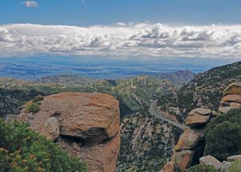
Views along this trail are as diverse as the biology, especially if you take the short side hike to the top of Mt. Bigelow. At this forest lookout location, you’ll find good views of Tucson to the west. The rest of the trail offers views to the east, of Alder Canyon and the San Pedro Valley.
Getting There
Elevation
8200
Directions
Take the Catalina Highway off Tanque Verde Road in Tucson. Drive 4.2 miles to the Forest boundary and continue 19 miles to the Palisades Visitor Information Center. The trailhead for Butterfly Trail is locatedjust before and across the highway from Palisades Visitor Center (signs read “Bigelow Trailhead”).. The upper trailhead is about another 4 miles up Catalina Highway at the Soldier Camp access road. The Catalina Highway is paved and suitable for passenger cars, but it may be snow-covered in winter when chains or 4-wheel drive may be required.
Facility and Amenity Information
Restrooms
Restrooms are not available at this site.
Water
Potable water is not available at this site.
Recreation Groups
SUMMERHAVEN and the SUMMIT AREA Less than one hour from downtown Tucson, perennial water, picnic areas, and a network of wooded trails offer recreation opportunities for al

The first 13 passages of the Arizona National Scenic Trail pass through the Coronado National Forest.