-
Roosevelt Lake Endangered Species Areas
Details below.
Alert Start Date: August 23, 2024
Alert End Date: August 22, 2029
Order Number: 03-12-06-24-09
Associated Documents
Forest Order
PROHIBITIONS
Pursuant to 16 U.S.C. § 551 and 36 C.F.R. § 261.50(a) and (b) the following are prohibited on the National Forest System (NFS) lands, roads, and trails in the Tonto Basin Ranger District, Tonto National Forest, described below and shown on the attached maps incorporated into this Order as Exhibits A and B (the “Described Areas and Roads”):
- Using any motor vehicle on the National Forest System Roads within the Described Area. 36 CFR § 261.54(a)
- Possessing or using a motor vehicle off National Forest System Roads. 36 CFR § 261.56
- Building, maintaining, attending, or using a fire, campfire, or stove fire. 36 CFR § 261.52(a)
- Smoking, except when stopped in an area at least 3 feet in diameter that is barren or cleared of all flammable material. 36 CFR § 261.52(d)
EXEMPTIONS
Pursuant to 36 C.F.R. § 261.50(e), the following persons are exempt from this Order:
- Persons with Forest Service Permit No. FS-7700-48 (Permit for Use of Roads, Trails, or Areas Restricted by Regulation or Order), specifically exempting them from this Order or a written determination by a Forest Service authorized officer that a permit is not required under 36 C.F.R. § 251.50(e)(1) or (2).
- Any Federal, State, or Local Officer, or member of an organized rescue or firefighting resource in the performance of an official duty.
- All motorized watercraft on the water within the Described Area.
DESCRIBED AREAS and ROADS
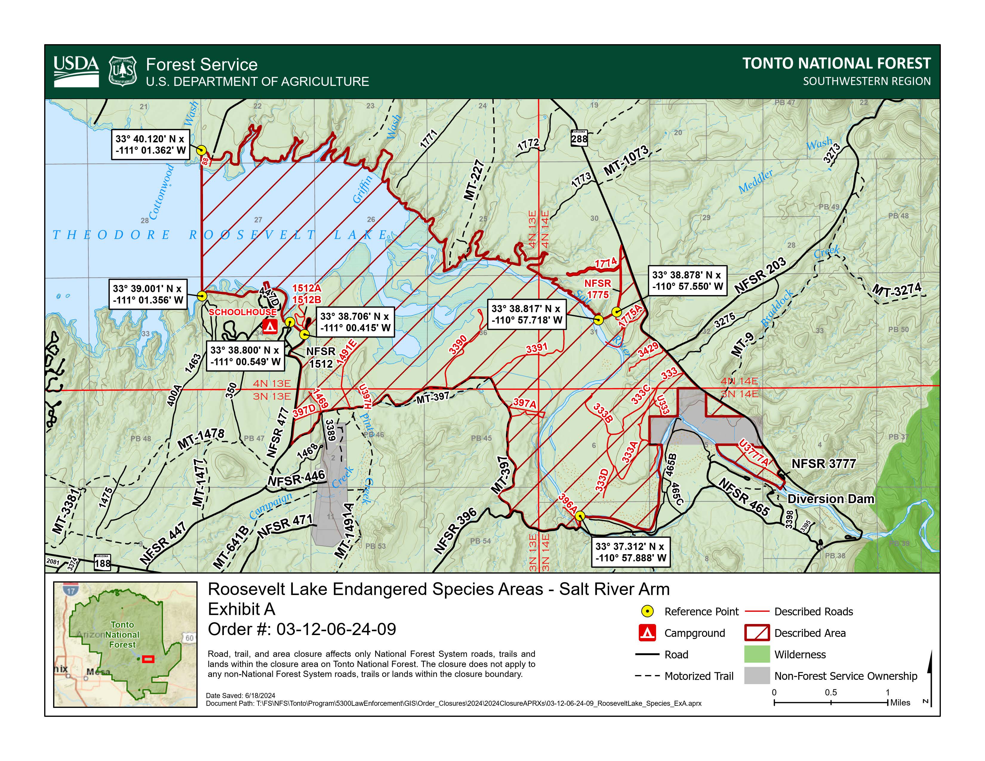
Salt River Arm of Roosevelt Lake (Exhibit A)
All National Forest System (NFS) lands, roads, trails, and waters, within Township 3 North Range 13 East Sections PB45-PB47 and PB54, Township 4 North Range 13 East Sections 22, 23, 25-27, and 34-36, Township 3 North Range 14 East Sections 4-8, Township 4 North Range 14 East Sections 30-32, starting at the intersection of NFS Road 396 and Motorized Trail (MT) 397, then following North and West along the East and North side of MT-397 approximately 3.5 miles to the intersection with NFS Road 477, then following North along the East side of NFS Road 477 approximately 0.9 miles to the intersection with NFS Road 1512, then following North on the East side of NFS Road 1512 around the parking lot back South along the West side of NFS Road 1512 approximately 0.5 miles to reference point (33° 38.706' N x -111° 00.415' W), then following directly Northwest to a reference point (33° 38.800' N x -111° 00.549' W) on the Theodore Roosevelt Lake Southern shoreline, then following North and West along the Southern shoreline approximately 1.25 miles to reference point (33° 39.001' N x - 111° 01.356' W), then following directly North approximately 1.25 miles to reference point (33° 40.120' N x -111° 01.362' W) on the Theodore Roosevelt Lake Northern shoreline, then following generally Southeast along the Northern shoreline approximately 9.5 miles to reference point (33° 38.817' N x -110° 57.718' W), the following directly Northeast approximately 0.2 miles to reference point (33° 38.878' N x -110° 57.550' W) on NFS Road 1775, then following North along NFS Road 1775 approximately 0.4 miles to the intersection with NFS Road 1774, then including NFS Road 1774 West approximately 0.5 miles to its terminus, then continuing to follow NFS Road 1775 North 0.2 miles to the intersection with State Route (SR) 288, then following Southeast along the Southwest side of SR 288 approximately 2.5 miles to the intersection with NFS Road 3777. Then following South along the West side of NFS Road 3777 approximately 0.25 miles to the intersection of the Salt River and Diversion Dam, then following Northwest, South, and West along the Salt River (Excluding the Non-Forest Service Ownership) to reference point (33° 37.312' N x -110° 57.888' W), then following directly South approximately 0.1 miles to the intersection of NFS Road 396A and NFS Road 396, then following West along the North side of NFS Road 396 approximately 0.8 miles back to the point of beginning at the intersection of the NFS Road 396 and MT-397.
Note: NFS Boundary Roads and Roads within the Closure, 1512A, 1512B, 397D, 1469, 1491E, U397H, 3390, 3391, 397A 396A, 333, 333A, 333B, 333C, 333D, U333, 3429, 1775, 1774, and 1775A.
Boundary Routes SR 288, NFS Roads 396, 477, 1512 and MT-397 remain open.
Tonto Creek Arm of Roosevelt Lake (Exhibit B)
All National Forest System (NFS) lands, roads, trails, and waters within the Boundary of Township 5 North Range 10 East Sections 7-9, 16-18, 20-21, and 28-29, starting at the intersection of NFS Road 60 and State Route (SR) 188, then following Northeast along the South side of the closed section of NFS Road 60 approximately 0.75 miles to the Non-Forest Service Ownership, then following around the Non-Forest Service Ownership to the junction with NFS Road 60, then following Southeast along the South side of NFS Road 60 approximately 1.25 miles to the intersection with NFS Road 661, then following Southwest along the West side of NFS Road 661 approximately 0.7 miles to a reference point (33° 46.736' N x -111° 14.640' W), then following directly West approximately 0.1 miles to a reference point (33° 46.736' N x -111° 14.753' W) on the fence line, then following generally South along the fence approximately 0.9 miles to a reference point (33° 46.129' N x -111° 14.567' W), then following directly Southwest approximately 0.4 miles to a reference point (33° 45.897' N x -111° 14.846' W) on the Theodore Roosevelt Lake Northern shoreline, then following generally East along the Northern shoreline approximately 1.25 miles to a reference point (33° 45.725' N x -111° 14.252' W), then following directly South approximately 0.75 miles to the intersection of Bumblebee Creek and SR 188, then following Northeast along the East side of SR 188 approximately 1.25 miles Orange Peel Recreation Site and NFS Road 659, then following North and East staying 100ft from NFS Road 659 approximately 0.25 miles to
SR 188, then following generally North along the East side of SR 188 approximately 1.75 miles back to the starting point at the intersection of SR 188 and NFS Road 60.
Note: Boundary Roads SR 188, NFS Roads 60, 661, and 659 remain open with the exception of the Closed section of NFS Road 60 near SR 188.
PURPOSE
The purpose of this Order is to protect and restore critical habitat important to endangered or threatened species of wildlife in compliance with the Endangered Species Act.
IMPLEMENTATION
- This Order shall be in effect from August 23, 2024, at 6 a.m. through August 22, 2029, at 10 p.m., unless rescinded.
- Maps identifying the Described Areas are attached and made part of this Order as Exhibits A & B. For a digital version of this Order and Exhibit A & B, go to https://www.fs.usda.gov/r03/tonto/alerts.
- Unless otherwise expressly defined in this Order, the terms used in this Order are defined by the regulations of the Secretary of Agriculture, 36 C.F.R. Chapter II, Parts 200-299. If there are terms in this Order that are not expressly defined in the Order or 36 C.F.R. Chapter II, Parts 200-299, their meaning shall be determined by their plain language definitions.
- A violation of the above prohibitions is punishable as a Class B misdemeanor by a fine of not more than $5,000 for individuals and $10,000 for organizations, or by imprisonment for not more than six months, or both. 16 U.S.C. § 551; 18 U.S.C. §§ 3559, 3571, and 3581.
- Contact the Tonto Basin Ranger District in Roosevelt, AZ, (602) 225-5395, and Tonto National Forest Supervisor’s Office in Phoenix, AZ, (602) 225-5200, for more information about this Order.
- This Order supersedes any previous orders prohibiting the same acts covered by this Order.
Contact Name:
Tonto Basin Ranger StationContact Number:
(602) 225-5395Maps
Images below will open full size in a new window.