
MVUM Frequently Asked Questions
What is a MVUM?
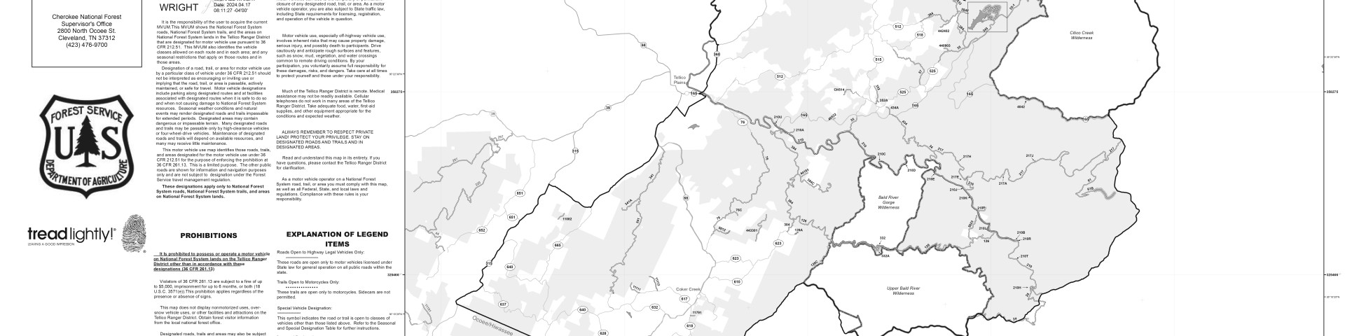
Motor Vehicle Use Maps are the official map for designating all roads and trails available for public motorized travel on the Cherokee National Forest. Visitors should not rely on any other maps for making decisions about motorized travel.
The MVUM displays National Forest System (NFS) routes (roads and trails) designated as open to motorized travel. The MVUM also displays allowed uses by vehicle class (ex. highway-legal vehicles, vehicles 50 inches in width or less and motorcycles); seasonal allowances, off route travel distance allowances, and provides information on other travel rules and regulations.
Routes not shown on the MVUM are not open to public motor vehicle travel. Routes designated for motorized use may not always be signed on the ground but will be identified on the MVUM. It will be the user’s responsibility to reference the MVUM and stay on designated routes for motor vehicle use.
The MVUM is a black and white map with few topographic features. It displays legal designations of where you can travel with various motorized vehicles, but for additional information it is best used in conjunction with a Forest Visitor Map, District Map(s), or other detailed map.
The MVUM is free to the public at local Ranger District offices and at the Supervisor’s Office. The MVUM is available on this website and sections of it may be printed from your home computer.
How do I print the MVUM?
A full-size version of the MVUM is 34” x 44” and cannot be printed on conventional home printers. A full-size version can only be printed from a large plotter. Many local copy shops, engineering and survey businesses can print the map.
To be readable, only a portion of the MVUM can be printed on 8 ½” x 11” paper using home printers. With PDF viewers/readers, such as Adobe Acrobat Reader, you can use the “Print Current View” function to print the view on your screen. It is recommended that the legend box be printed to aid in interpretation of the MVUM.
What does a MVUM show me?
The map displays all National Forest System roads and trails allowing public motor vehicle use. This is commonly referred to as designation. It also states that driving off designated roads and trails is prohibited (36 CFR 261.13).
Motorized use includes but is not limited to Motorcycles, ATVs, and 4-wheel drive vehicles.
Designation details include vehicle class, time of year, and motorized access for the purpose of dispersed camping (camping in locations other than developed campgrounds).
Limited motor vehicle access may occur on routes not shown on the MVUM for the purpose of administrative access by Forest Service personnel; for fire and law enforcement; for emergency purposes; and by persons authorized by a written special use permit or contract from the Forest Service.
Does the MVUM also show non-motorized trails and over-snow vehicle uses?
No, a visitor map or snowmobile map will provide information on over-snow and non-motorized routes, including mechanized trails, hiking, and horse trails. Over-snow vehicle use is exempted from designations on the MVUM. Regardless of what other maps (including the Forest Visitor Map) may show as motorized routes, only those routes identified on the MVUM are designated as open to public motorized use and legal for public motorized travel.
Are there road and trail route marker signs on the ground?
On the Cherokee National Forest our goal is to have most, if not all, of our motorized travel routes signed at primary junctions. In some cases, a route marker may exist at the entrance of the road/trail with symbols indicating which classes of vehicles are allowed. Routes designated for motorized uses will be identified on the MVUM. The MVUM is an enforcement tool to ensure individuals are on the correct route.
It is the responsibility of the user to determine if they are on a route designated for the motor vehicle being used. MVUM's will be developed for each forest nationwide. It is not only a tool for motorized users, but also a consistent and standardized law enforcement tool.
After MVUMs are available to the public in map form and on the web, what will be the USFS enforcement strategy?
When new regulations are posted, the Forest Service provides some time to educate the public about the specifics of the regulation. Law enforcement officer contact with the public is a great opportunity to provide information education and create awareness about what information the MVUM conveys. However, law enforcement officers can issue a notice of violation anytime after the MVUM is publicly available.
You can help us maintain this system and keep these opportunities open to all motorized users by letting us know when other users abuse their privilege and travel on routes closed to motorized use by calling any of the Cherokee National Forest Offices.
How can I find another Forest’s MVUM?
Click this link to the National Website to view a MVUM for another location.