





North Fork Recreation Area
North Fork Recreation Area provides camping, picnicking, boating, canoeing, hiking and fishing access to the beautiful North Fork of the White River, which has a total of nine major springs flowing into it.
As you drive into the site, the first right takes you to the boat access area. If you go straight you’ll hit a t-intersection, if you go left you enter the campground, if you go right you enter the day use.
The site is surrounded by an oak/hickory forest, there are a lot of tulip poplar and sycamore in that area.
From the day use area, and sometimes the campground, you have amazing views looking across the river of the mixed hardwood and pine forest and the rock bluffs that envelope the river. On the other side of the river is the beginning of the Devils Backbone Wilderness Area. Some sites have views of the river before trees and bushes leaf out.
North Fork Recreation Area serves as trailhead for the 35-mile long Ridge Runner National Recreation Trail and the Blue Spring Trail.
There are multiple springs that contribute to the river, one of the largest is Blue Spring, which contributes around 7 million gallons of cold, clear water every day to the river. Near North Fork, from the river you can paddle up into Blue Spring or hike the Blue Spring Trail. The spring is about 30 feet in diameter. One three sides, the stone wall is made of cherty Gasconade dolomite that surrounds the spring and represents the karst topography of Ozarks.
Active Alerts
General Information
Camping and RV Camping
Each site has a table, fire ring with grills on them, and tent pad. Drinking water, vault toilets and garbage collection are centrally located.
No. of Sites - 19 single sites
- All sites are first come, first serve at the campground, and reservations cannot be made in advance
- Sites are spread out around three loops, and are relatively private from each other.
- Sites are suitable for small, under 30’, travel trailers, but some can accommodate up to 34' RVs.
- Sites are spread out around three loops, and are relatively private from each other.
- No water and sewer hookups available at this location.
- The use of generators is not prohibited, but remember quiet hours start at 10:00 PM.
Vehicle Clearance - No restrictions
Pavement Type of Parking - Asphalt
Campground
Open May 1 - December 1, 2026
Day Use Area
Open year-round
Campground
- Open 24 Hours a day to campers.
- Quiet Hours: 10:00 PM to 6:00 AM
- Check out time: 2:00 PM
Day Use Hours:
- 6:00 AM to 10:00 PM
Camping
- Only collect dead and downed wood for campfires.
- In Campground
- Campsite parking allows for two vehicles per site. Park only in designated parking areas.
- No more than 8 people are permitted at single sites (16 for double sites).
- Please use trash containers located at the day use area and in the campground
- Please adhere to posted speed limits
- No horses in the recreation area
- Dogs must be on a 6-foot leash within the Campground and Day Use Area
- In Devils Backbone Wilderness
- Camp 100 feet away from trails and water sources.
- Human waste (Feces) must be buried at least 6 inches deep and covered.
- Pack out all of your garbage.
On the Trail
- No motorized vehicles are allowed on the trail or past designated parking areas.
- Dogs are allowed on hiking trails, please ensure they are under control.
- Leashing is encouraged. Unleashed dogs can pose a danger to other pets, the natural resources of the area, wildlife, and other forest visitors.
At the Trailheads
- No overnight camping in day use areas/trailheads at any time of year.
- Dogs must be on a 6 foot leash in the day use area
- No trash containers; please pack out all your trash.
- Fireworks are prohibited.
- Horses may not be tied directly to trees.
Day Use Fees
Day Use Fees can be paid on-site using the provided fee tubes.
- Fees must be paid using cash or check, no credit card machines are available at any sites.
- Annual and Lifetime passes can be purchased to cover day use fees at USDA Forest Service operated sites.
Camping Discount
- There is a 50% discount for camping for anyone with an Interagency Access or Senior Pass.
- The discount applies only to the fee for the campsite physically occupied by the pass holder, not to any additional fee or campsite(s) occupied by members of the pass holder's party.
Overnight Use:
Single Site: $10 per night
Day Use:
$2 per vehicle per day
Commercial Vehicle: $10 per vehicle
$20 per annual
Campground: Fees will be paid at the fee tubes provided for camping, day use, and the boat launch
Trail Use
Dogs are allowed on hiking trails. Please leash your dog, unleashed dogs can pose a danger to your pet, the natural resources of the area, and other forest visitors.
- Leashes must be six feet, or shorter, when in developed recreation sites, including trails within the boundaries (36 CFR 261.16(j)) when they are not inside an enclosed vehicle or tent.
- Yield your leashed dog around other hikers and horses.
- Pack out your dogs waste or bury it 100 feet from water and trails.
Camping
- Keep dogs on a six-foot, or shorter, leash when they are not inside a tent.
- Store dog food in bear-resistant containers and feed your pet away from the campsite.
- Pick up and bag your dog’s waste. Place it in a provided trash receptacle or pack it out.
- Do not leave your dog unattended at any time.
- Do not leave your dog in the vehicle on a hot day.
- Keep your dog in your tent or vehicle at night.
- Ensure that there is ample water available for your pet.
Wildlife
- Do not allow them to interact with wildlife
- Sunburst Ranch
- Dawt Mill (Ozark Mills Carriage Company)
- Twin Bridges Canoe Rental
- Petit Canoe Rental
- River of Life Resort

Address: 1006 S. Jefferson Ava, MO 65608
Phone: 417-683-4428
Hours: 8:00 am - 4:30 pm, Monday to Friday; District Offices closed 1 - 1:30 for lunch (Closed on federal holidays)
Office Email: sm.fs.marktwainnf@usda.gov
Getting There
Latitude / Longitude
Latitude: 36.758606
Longitude: -92.152801
Directions
From West Plains, MO
- take State Route CC west 18 miles
- The site is on the left side of the road
From Dora
- From Highway 181 just south of Dora, MO for 4.7 miles,
- Turn left and take State Route CC 3 miles east.
- The site is on the right side of the road
Parking
- Day Use: 20 vehicles
- Boat Launch: 10 vehicles with trailers
- Campsites: Campsite parking allows for two vehicles per site. Park only in designated parking areas.
Facility and Amenity Information
Accessibility
Several picnic tables, toilets, handicap parking at the day use area are accessible.
Restrooms
Vault toilet(s)Water
Potable water is not available at this site.
Picnic Tables
Picnic tables are available at this site.
There are 4 sites for day use picnicking with grills and tables.
Horse/Pack Animal Information
Horse/Pack animals are not allowed at this site.
Horses are not allowed within the recreation area and not allowed on the Blue Spring Trail.
Nearby Trails
- Blue Spring Trail
- Devils Backbone Wilderness Trail
- Ridge Runner National Recreation Trail
- Ozark Trail - North Fork Section
Recreation Opportunities


Backpacking Info
Day hikers can enjoy the 0.6 mile Blue Spring Trail, or portions of the Ridge Runner Trail or Devils Backbone Wilderness Trails.
Blue Spring Trail - .6 miles
This very short walk takes you from North Fork Campground to the beautiful Blue Spring. The Trail parallels the North Fork of the White River and travels into the Devil’s Backbone Wilderness.
Ridge Runner Trail - 33 miles
The Ridge Runner Trail, a National Recreation Trail, consists of a 6 mile loop at Noblett Lake, a 6 mile loop near the North Fork Recreation Area, and a 21 mile long segment in between that extends from Noblett Lake in the north to the North Fork Recreation Area in the south.
Devils Backbone Wilderness Trails - 13 miles
Thirteen miles of maintained foot and horse trails follow the Devils Backbone and four other ridges, dropping off into surrounding hollows in a forest dominated by oaks, hickories, and shortleaf pines.
Day Hikes Info
Day hikers can enjoy the 0.6 mile Blue Spring Trail, or portions of the Ridge Runner Trail or Devils Backbone Wilderness Trails.
Blue Spring Trail - .6 miles
This very short walk takes you from North Fork Campground to the beautiful Blue Spring. The Trail parallels the North Fork of the White River and travels into the Devil’s Backbone Wilderness.
Ridge Runner Trail - 33 miles
The Ridge Runner Trail, a National Recreation Trail, consists of a 6 mile loop at Noblett Lake, a 6 mile loop near the North Fork Recreation Area, and a 21 mile long segment in between that extends from Noblett Lake in the north to the North Fork Recreation Area in the south.
Devils Backbone Wilderness Trails - 13 miles
Thirteen miles of maintained foot and horse trails follow the Devils Backbone and four other ridges, dropping off into surrounding hollows in a forest dominated by oaks, hickories, and shortleaf pines.
 Fishing - River/Stream
Recreation Groups
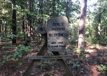
Visit the land where a steep, narrow, ridge drops away, plunging into deep hollows. Welcome to Devils Backbone Wilderness Area.
Ridge Runner National Recreation Trail is a 33-mile long trail, with two six-mile loops at either end and a 21-mile section between them.