Ozark Trail: Brushy Creek Trailhead
This trailhead is the western-most trailhead of the Victory Section of the OT.
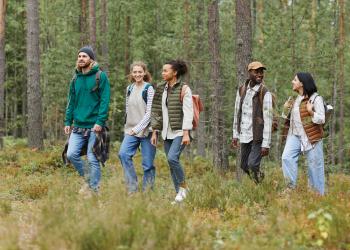
The Brushy Creek trailhead provides access to the Ozark Trail's Victory Section. The Victory Section of the Ozark Trail is named after the one-room schoolhouse that formerly stood near the Victory Trailhead. This isolated section of the Ozark Trail is separated from the Wappapello Lake Section’s southern terminus by the Black River and three miles of rugged terrain. The trail follows through heavy oak forests, with small meadows and streams providing variety in the landscape. Water is available in creeks along the trail.
Photos of Brushy Creek


General Information
Dispersed Camping
You can dispersed camp along the Ozark Trail.
Dispersed camping is the term used for free camping anywhere in the National Forest OUTSIDE of a designated campground. Dispersed camping means there are no toilets, no structures, no trash cans, no treated water, and no fire grates. There are extra responsibilities required for this type of camp. It's a must to educate yourself before you try it, but we hope the adventure of dispersed camping in the Mark Twain National Forest calls to you!
- Pick a Campsite and follow the Leave No Trace Principles
- Camp 100 feet away from trails and water sources.
- Treat any water found in the area before consuming it.
- Human waste (Feces) must be buried at least 6 inches deep and covered.
- Pack out all of your garbage.
January - December
6 a.m. to 10 p.m.
On the Trail
- No motorized vehicles are allowed on the trail or past designated parking areas.
At the Trailhead
- No overnight camping in day use areas at any time of year.
- Dogs must be on a 6 foot leash in the day use area
- No trash containers in the parking lot; please pack out all your trash.
- Fireworks are prohibited.
Trail Use
Dogs are allowed on hiking trails, as long as they are kept on a leash. Unleashed dogs can pose a danger to your pet, the natural resources of the area, and other forest visitors.
- Leashes must be six feet, or shorter, when in developed recreation sites, including trails within the boundaries (36 CFR 261.16(j)) when they are not inside an enclosed vehicle or tent.
- Yield your leashed dog around other hikers and horses.
- Pack out your dogs waste or bury it 100 feet from water and trails.
Camping
- Keep dogs on a six-foot, or shorter, leash when they are not inside a tent.
- Store dog food in bear-resistant containers and feed your pet away from the campsite.
- Pick up and bag your dog’s waste. Place it in a provided trash receptacle or pack it out.
- Do not leave your dog unattended at any time.
- Do not leave your dog in the vehicle on a hot day.
- Keep your dog in your tent or vehicle at night.
- Ensure that there is ample water available for your pet.
Wildlife
- Do not allow them to interact with wildlife

Address: 1420 Maud St. Poplar Bluff, MO 63901
Phone: 573-785-1475
Hours: 8:00 am - 4:30 pm, Monday to Friday; District Offices closed 1 - 1:30 for lunch (Closed on federal holidays)
Office Email: sm.fs.marktwainnf@usda.gov
Getting There
Latitude / Longitude
Latitude: 36.972628
Longitude: -90.74603299
Directions
from Ellsinore, MO: Take Highway V to the north about 4 miles and the trailhead will be on the left side of the road.
Parking
The trailhead has ample parking for multiple cars or a few trucks with trailers.
Facility and Amenity Information
Restrooms
Restrooms are not available at this site.
Water
Potable water is not available at this site.
Nearby Trails
Recreation Opportunities
Horseback Riding Info
Four trailheads offer access to the western section of the completed trail: Wrangler to the east, Upalika Pond near the center, Brush Arbor also in the middle of the section, and Brushy Creek, on the northwest end of this trail section.
Water for horses is available near all trailheads except Wrangler. Access to the adjoining Victory Horse Trail is located near the Wrangler Trailhead.
The Victory Section of the Ozark Trail is a 19.4-mile point-to-point with a six-mile loop on its eastern end called the Victory Horse Trail.
It is located in Wayne, Butler, and Carter Counties, near the communities of Ellsinore and Hendrickson.
Backpacking Info
Four trailheads offer access to the western section of the completed trail: Wrangler to the east, Upalika Pond near the center, Brush Arbor also in the middle of the section, and Brushy Creek, on the northwest end of this trail section.
Water for horses is available near all trailheads except Wrangler. Access to the adjoining Victory Horse Trail is located near the Wrangler Trailhead.
The Victory Section of the Ozark Trail is a 19.4-mile point-to-point with a six-mile loop on its eastern end called the Victory Horse Trail.
It is located in Wayne, Butler, and Carter Counties, near the communities of Ellsinore and Hendrickson.
Day Hikes Info
Four trailheads offer access to the western section of the completed trail: Wrangler to the east, Upalika Pond near the center, Brush Arbor also in the middle of the section, and Brushy Creek, on the northwest end of this trail section.
Water for horses is available near all trailheads except Wrangler. Access to the adjoining Victory Horse Trail is located near the Wrangler Trailhead.
The Victory Section of the Ozark Trail is a 19.4-mile point-to-point with a six-mile loop on its eastern end called the Victory Horse Trail.
It is located in Wayne, Butler, and Carter Counties, near the communities of Ellsinore and Hendrickson.
Biking - Mountain Info
Four trailheads offer access to the western section of the completed trail: Wrangler to the east, Upalika Pond near the center, Brush Arbor also in the middle of the section, and Brushy Creek, on the northwest end of this trail section.
Water for horses is available near all trailheads except Wrangler. Access to the adjoining Victory Horse Trail is located near the Wrangler Trailhead.
The Victory Section of the Ozark Trail is a 19.4-mile point-to-point with a six-mile loop on its eastern end called the Victory Horse Trail.
It is located in Wayne, Butler, and Carter Counties, near the communities of Ellsinore and Hendrickson.
Recreation Groups