
Stop 4: Watershed Divide
Watershed Divide is the location where rainwater flows north or south into streams in the glade top area. Everything south of the divide flows into Big Creek. Everything north of the divide flows into Beaver Creek.
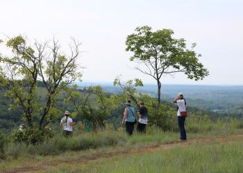
The Glade in front of you became encroached with Eastern Red Cedar due to exclusion of fire. This photo was taken before restoration activities began. In 2013, it was covered in Eastern Red Cedar (Juniperus virginiana). These trees are native to Missouri, but is a prolific invader of open lands. Because of the amount of Eastern Red Cedar found on glades today, glades are often referred to as cedar glades. Prior to settlement, eastern red cedar were primarily found only rocky bluffs.
In glades historically, wildfire played an important role in maintaining the treeless character of glades. A study of tree rings on glades in this area showed that between 1730 and 1870 (before significant European settlement) the average fire frequency was every 3.2 years. As the population grew, fire was suppressed and not allowed to burn across the landscape. These glades became encroached by Eastern Red Cedar trees which suppressed the native plants and wildflowers common in healthy glade ecosystems.
The Forest Service is restoring glades by removing Eastern Red Cedar and introducing prescribed fires to replicate historic fire frequencies. This keeps the area open, allowing native plants and wildflowers to grow, that enhances wildlife habitat including pollinators. These conditions provide important habitat for a variety of wildlife including songbird, pollinators, wild turkeys and white-tailed deer.
Periodic prescribe burns will mimic historic fire patterns, encourage additional development of grasses and forbs, restoring and maintaining a Healthy Functional Glade.
Fun Fact: Where do the Glade grasses and forbs come from?
Before the dense stand of cedar trees established, a rich abundance of sunlight-loving glade grasses and wildflowers (forbs) carpeted the landscape. Each year, the plants would flower, develop seeds, and seeds would be dispersed. Not every seed produced by a plant germinates (sprouts) the next growing season. Many seeds remain in the soil for some time; this is called the soil seed bank. These seeds can stay dormant in the soil for years before germinating under good conditions (moisture, temperature, light, competition, etc.). As the cedar trees grew and became dense on the landscape, their canopy expanded, shading the ground beneath them and casting a thick matt of dead needles below them.
The shade, and changing soil conditions from the needle cast reduced the amount of blooming glade plants that could survive below the cedar trees, and eventually no vegetation grew in the understory.
After the cedars were cut, and fire was returned to the landscape, the layer of cedar needles was burned away and sunlight was no longer blocked from the soil surface. Light, the addition of nutrients from the ash, and the change in soil pH (acidity) began to restore the soil conditions needed by the seeds within the soil seed bank. Then seeds began to germinate, and you see the beautiful wildflowers blooming once more.
General Information
January - December
Day Use, 6 am to 10pm
When visiting, please remember
- No overnight camping in day use areas at any time of year.
- Dogs must be on a 6 foot leash in the day use area
- No trash containers; please pack out all your trash.
- Fireworks are prohibited.
No fees
When at stops please keep your dog on a 6-foot (or shorter) leash. Don't forget to bring waste bags to clean up after them.
None of the stops have drinking water so make sure to bring enough water (and snacks!) for your furry companion.

Address: 1006 S. Jefferson Ava, MO 65608
Phone: 417-683-4428
Hours: 8:00 am - 4:30 pm, Monday to Friday; District Offices closed 1 - 1:30 for lunch (Closed on federal holidays)
Office Email: sm.fs.marktwainnf@usda.gov
Getting There
Latitude / Longitude
Latitude: 36.75716
Longitude: -92.746461
Directions
From Ava, MO
The byway begins outside of Ava:
- go south on Hwy 5 for three miles to Hwy A
- turn right/west on Hwy A and drive 4 miles to Smallett Junction,
- turn left/south on A409 and Hayden Park
- Drive for 5.1 miles on A409 to get to Watershed Divide
Parking
7 vehicles
Facility and Amenity Information
Restrooms
Restrooms are not available at this site.
Water
Potable water is not available at this site.
Recreation Opportunities
Driving Routes Info
Glade Top National Scenic Byway
Glade Top Trail became a National Forest Scenic Byway in 1989.
While much of the Glade Top Trail was significantly improved or constructed outright by the Civilian Conservation Corps (CCC) during the 1930s to the early 1940s, it is probable that a significant proportion of the Trail was used by settlers to access many of the homesteads that existed throughout the region during the late nineteenth and early twentieth centuries. Prior to that time, these same routes of travel were likely used by Native American peoples as they traversed the landscape in pursuit of the area’s natural resources.
Recreation Groups
This 23-mile Scenic Byway is named for the beautiful glades that surround the ridge tops where the Scenic Byway traverses.