
Rockpile Mountain Trail
The trail is located in the Rockpile Mountain Wilderness Area, from the trailhead there is a 2 mile section of maintained trail. The rest of the area is accessed by old woods roads or cross-country hiking.
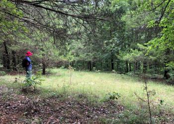
The trail begins on the summit of Grassy Mountain, and from there descends from 960 to 520 feet above sea level as the path clings along the slopes and descends into the hollow below. The trail shepherds hikers along for two miles of uneven terrain before fading into the rugged landscape. Then the trail divides multiple times to follow abandoned logging and mine roads that access the rest of the area. The maze of trails requires good orienteering skills.
Signage is infrequent, and the trailhead is sheltered from the slope by growth of trees. A large boulder carved with the words “Rock Pile Wilderness” marks the beginning of the trail. The road up Little Grassy Mountain to the trailhead is steep, and frequently washed out.
Rating: Moderate. Terrain is sometimes steep. The area is within the St. Francois Mountains where elevations range from 1,305 to 520 feet.
Length: 2 miles.
Best Seasons: Fall, winter, and spring.
Surface Type: Unsurfaced, native material.
Specific Trail Information
Trail Number
Trail Type
General Information
Camping
Protect the solitude; seek out campsites in the Wilderness that are out of sight and sound of trails and other camps. When sharing an area keep a low profile and maintain the solitude.
Hercules Tower Trailhead
There are five campsites, two are down a set of stairs. The other 3 are located next to the parking areas. There are picnic tables and fire rings at each site.
Coy Bald Trailhead
There are 3 pull-in sites where you can camp with picnic tables and fire rings.
The Ozark climate is mild enough to make Wilderness visits feasible throughout the year, as long as visitors bring proper gear. When possible, take advantage of this opportunity and plan your 'visit outside the peak spring and fall use seasons.
Private Property – Rockpile Mountain Wilderness is surrounded by private property. Please respect the rights and property of private landowners.
Safety Information
Wilderness has inherent dangers, and is a primitive setting where you meet nature on its own terms.
- Bring a map and compass, and first aid kit.
- During temperate months, be prepared for biting insects, poison ivy and high temperatures.
- Be advised of hunting seasons.
- Avoid using the trail during excessively wet periods.
- Be sure to tell someone your plans, don’t hike the wilderness alone and carry extra supplies so you are prepared to take care of yourself in case you get lost, injured, or delayed.
- The universal distress signal is three of anything: shots, shouts, smokes, whistles.
- Be prepared to sanitize water for drinking
For more safety tips visit the Safety section of the website.
No fees.
No water at trailheads, filter or boil water along the trail.
- Camp at least 100 feet from the trail,
- treat all water used,
- bury human waste
- pack out all trash
- foot and horse use only

Address: 10019 W. State Hwy. 8 Potosi, MO 63664
Phone: 573-438-5427
Hours: 8:00 am - 4:30 pm, Monday to Friday; District Offices closed 1 - 1:30 for lunch (Closed on federal holidays)
Office Email: sm.fs.marktwainnf@usda.gov
Getting There
Directions
From St. Louis, take I-55 south to Hwy. 67; then south to County Road C south of Fredericktown; then south 10 miles to County Road 406 to FR2124.
Additional Information
Operated By
USDA Forest Service
Nearby Recreation Sites
Recreation Opportunities
Viewing Scenery Info
Rockpile Mountain itself, the steep limestone bluffs, rock formations, and caves along the St. Francis River. The narrow gorges or "shut-ins" with rushing cascades during periods of runoff and the scattered granite glades add variety to the wilderness landscape, as well as unique plant and animal communities.
Recreation Groups
This 4,238 acre Wilderness takes its name from an ancient circle of granite rock, piled by some earlier man on top of the mountain.