Recreation
Bonneville Trailhead
Site Open
Provides access to Tamanous Trail #27, which connects hikers to the Pacific Crest Trail.The parking area has plenty of room for horse trailers.This is also a Northern Pikeminnow collections…
Bridge Of The Gods Trailhead
Site Open
Provides access to: Pacific Crest National Scenic Trail #2000 which accesses Mark O Hatfield Wilderness to the south, and the state of Washington to the north across the Columbia River. The…
Cape Horn Overlook
Site Open
Cape Horn Overlook is accessed via Cape Horn Trail #4418. Follow Cape Horn Trail for a scenic 2 mile hike to Cape Horn Overlook. The site was developed in dedication to Nancy Russell, who saved this…
Catherine Creek Loop
Site Open
This 1.9 mile loop, northeast of the Catherine Creek Trailhead, offers spectacular wildflower viewing during the spring and passes within sight of a natural arch. The vicinity surrounding the arch is…
Catherine Creek Recreation Area
Site Open
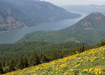
One of the premier areas for early spring wildflower viewing in the eastern Columbia River Gorge, Catherine Creek Recreation Area is popular each spring before it dries up by mid summer. The…
Columbia Gorge Discovery Center
Site Open
Located just west of The Dalles, OR, the Columbia Gorge Discovery Center is the official interpretive center for the Columbia River Gorge National Scenic Area. This 26,100 square foot exhibit wing…
Columbia River - Oregon Shoreline Access
The Columbia River Gorge Scenic Area is home to one of the most spectacular stretches of the Columbia River. These state, county, and local parks provide shoreline access from the Oregon side. Be…
Columbia River - Washington Shoreline Access
The Columbia River Gorge Scenic Area is home to one of the most spectacular stretches of the Columbia River, and within our boundaries lie a variety of state, county, and local parks that provide…
Coyote Wall Recreation Area
Site Open
A massive formation of columnar basalt, Coyote Wall is one of the Columbia River Gorge's most recognizable features from all directions. Known around the Gorge as "The Syncline", local amateur…
Dog Creek Falls Observation Site
Site Open
A small pulloff of Washington State Route 14 with a very short hike (0.1 mile) to a viewpoint of Dog Creek Falls. Take a swim in this cool creek or enjoy train-watching!


