August Complex Restoration on the Six Rivers National Forest

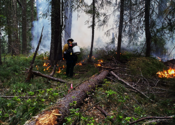
August Complex Fire – September 9, 2020. USFS Photo


Background

On August 16 and 17, 2020, lightning-ignited the August Complex, scorching 1,032,648 acres of private lands and riparian and upland forest habitats administered by the Six Rivers, Shasta-Trinity and Mendocino national forests. On the Mad River Ranger District of the Six Rivers National Forest (SRNF), dramatic wind-driven fire spread fueled by dense forest vegetation affected approximately 160,000 acres. Internal scoping and data gathering for the existing condition for this project began with the preparation of the August Fire Complex Vegetation & Resource Rapid Assessment (December 2020) that addressed all three forests. A fire perimeter map of the August Complex is provided here.

Six Rivers NF August Complex Fire Restoration Efforts

With approximately 160,000 acres affected by the fire there is a tremendous amount of work to be done to promote the recovery of your public forest lands. These efforts have brought together many agencies and organizations all working together to make this recovery possible. It is our mission to ensure that this recovery effort is pursued in the most logical, efficient, and timely manner possible.  The primary goals being pursued are restoration, reforestation, and fuelbreak maintenance and development. To realize these goals, our first tasks will be conducting hazard tree removal for public and firefighter safety and commercial fire salvage operations. To date, the SRNF has worked with the Shasta-Trinity and Mendocino national forests to produce the Rapid Vegetation Assessment in the immediate aftermath of the August Complex Fire. Using this assessment, we have initiated multiple recovery projects including BAER, CalOES road access permit, Three Forks Salvage Project, and Mad River August Complex Fire Restoration Project

Rapid Vegetation Assessment

In response to the August Complex Fire, the three forests worked across boundaries to develop a rapid assessment of field-verified post-fire conditions. The forests will use the August Fire Complex Vegetation & Resource Rapid Assessment (December 2020) as a guide for immediate and future vegetation management opportunities, especially those related to public safety. 

Burned Area Emergency Response (BAER)

The SRF has received emergency funding for road and trail treatments, and protection and safety treatments.  Currently, forest teams are surveying and identifying treatments to be implemented this summer.  For more information about the August Complex Post-Fire BAER work, visit https://inciweb.nwcg.gov/incident/7228/.

CalOES Project

The US Forest Service provided access via a road-use permit to California Governor’s Office of Emergency Services (CalOES) and their contractor, Pacific States-Sukut-P31 (PSP), to remove and dispose of metal, ash/debris, concrete, and contaminated soils resulting from the August Complex wildfires. The forest also allowed the improvement—and subsequent decommissioning—of a user-defined trail to access boat-in-only lease lots for hazardous materials removal.

Three Forks Fire Salvage Project

This project is in the planning phase and we are currently working on preparing a decision memo. The proposed project includes approximately 139 acres of commercial ground-based timber harvest of fire killed trees (70 to 100 percent mortality) and approximately 23 miles of roadside hazard tree removal. The work includes:

  1. Hazard Tree Removal: Dead trees deemed to be a hazard under the Region 5 hazard tree guidelines will be analyzed and considered for removal, prioritizing locations around high use roads, trail heads, campgrounds or other administrative sites and along motorized trails. Trees may be included in a commercial sale, left on site or used for other purposes. 
  2. Fire Salvage (Commercial): Patches of high severity timber will be removed in preparation of reforestation.

For additional information about this project, visit www.fs.usda.gov/project/?project=59645.

Mad River August Complex Fire Restoration Project

A landscape restoration approach to promote public and forest worker safety, this project includes 225 miles of roadside hazard tree removal, accelerates post-fire recovery of oak woodlands and Special Habitats (4,000 acres), establishes roadside/ridge-top fuel corridors (1,000 acres), and recovers commercial value from timber salvage forest by-products (1,488 acres). Public scoping is planned for May 2021 with a decision expected by late summer 2021. This focused-NEPA (National Environmental Policy Act) project, which combines the scoping and comment periods, proposes to restore areas already surveyed and authorized for vegetation management prior to the August Complex. The work will focus on the following actions:

  1. Hazard Tree Removal: Dead trees deemed to be a hazard under the Region 5 hazard tree guidelines will be analyzed and considered for removal, prioritizing locations around high use roads, trail heads, campgrounds or other administrative sites and along motorized trails. Trees may be included in a commercial sale, left on site or used for other purposes. 
  2. Fire Salvage (Commercial): Patches of high severity timber will be removed in preparation of reforestation.
  3. Oak Woodland Restoration: Oak woodland restoration areas have been identified to increase elk habitat and other ecological benefits. Restorative and maintenance understory burning will be implemented to maintain open spaces and habitat. Oak stands with low to moderate fire severity that have conifer encroachment and inter-stand competition will be analyzed for conifer removal whether by hand or mechanical treatment.
  4. Reforestation: In order to establish successful future shading, mixed conifers will be planted at stocking levels adequate to ensure the establishment of a successful shaded fuelbreak.  Management methods will be used to provide the best opportunity for these planted trees to be resilient to introduced fire, including hand grubbing to minimize competing vegetation, pruning to reduce ladder fuel effects and favoring hardwood tree species sprouts to re-occupy the site versus brush species. Reforestation will be implemented to accelerate forest recovery.
  5. Roadside and Ridgetop Fuels Corridors: Dead Trees—as determined by 2011 Region 5 fire-injured marking guidelines—and sub-merchantable dead conifers 4 inches in diameter and above, and brush will be removed generally along designated Forest Service roads, strategic ridgetops and other high-value resources. The clearance strip may reach out wider if terrain provides an opportunity to successfully establish an effective fuelbreak. 
  6. Legacy Sediment Sources: The proposed action will meet requirements of the California Regional Water Quality Control Board, North Coast Region Categorical Waiver of Waste Discharge Requirements for Nonpoint Source Discharges Related to Certain Federal Land Management Activities on National Forest System Land (Waiver). 
  7. Development of Radio Repeater: A new radio repeater site will be analyzed for development and installation at Grizzly Mountain. This will replace the burned-over Kettenpom site.

A map of the Mad River August Complex Fire Restoration Project area is available here.