
About the Area
The Pike-San Isabel National Forests & Cimarron and Comanche National Grasslands cover more than three million acres from the prairies of southwestern Kansas to Colorado's highest mountain peaks along the Continental Divide. These sprawling forests and grasslands are an eight-hour drive from boundary to boundary, offering diverse landscapes rich in history, geology, scenery, wildlife habitat and recreation opportunities.
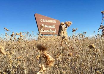
Cimarron National Grassland
District Ranger: Nancy Brewer
The Cimarron National Grassland manages about 108,175 acres in Morton and Stevens counties in southwestern Kansas. It is the state's largest area of public land and the only parcel managed by the Forest Service. The elevation ranges from 3,150 to 3,540 feet.
Comanche National Grassland

District Ranger: Kurt Staton
The district manages more than 440,000 acres in southeastern Colorado, including the nation's largest dinosaur tracksite. The Comanche National Grassland is a place of unequaled sunsets, golden prairies, fragrant juniper canyonlands and extraordinary wildlife viewing.
Leadville Ranger District

District Ranger Pat Mercer
The Ski Cooper Ski Area at Tennessee Pass is in the northern part of the Leadville Ranger District, Fremont Pass is in the northeastern part, headwaters of the Arkansas River can be accessed from the east, and Independence Pass can be accessed from the west.
Pikes Peak Ranger District

District Ranger Carl Bauer
The Pikes Peak Ranger District is home to "the purple mountain majesty" known as Pikes Peak. It is known as "America's Mountain" thanks to the song "America the Beautiful," which was written on its summit. The district office is in Colorado Springs, Colorado’s second largest city, with a population of about 500,000.
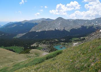
Salida Ranger District
District Ranger Sarah Wiener
The Salida Ranger District encompasses more than 440,000 acres of public lands in central Colorado near the towns of Salida, Buena Vista and Poncha Springs. The district includes seven 14,000-foot peaks called "fourteeners" (Harvard, Tabeguache, Yale, Columbia, Shavano, Princeton and Antero), as well as three wilderness areas (Buffalo Peaks, Collegiate Peaks and Sangre De Cristo) and Browns Canyon National Monument.
San Carlos Ranger District

District Ranger Destiny Chapman
San Carlos Ranger District is 50 miles wide and 110 miles long from central Colorado to the southern boarder. The district manages about 400,000 acres of national forest land in Fremont, Custer, Huerfano, Pueblo, Las Animas and Costilla counties.
South Park Ranger District
District Ranger Josh Voorhis
South Park Ranger District manages more than 500,000 acres in Park and Teller counties. The district office is in Fairplay, Colorado, with a work center in Lake George. The district ranges in elevation from 7,100 to 14,285 feet.
South Platte Ranger District

District Ranger Brian Banks
The South Platte Ranger District is located east of the Continental Divide in the central Rocky Mountains, adjacent to the Denver metro area. The district is 450,000 acres with elevations ranging from 5,800 feet along the South Platte River to over 14,000 feet at Guanella Pass and Mount Bierstadt.