





Mount Elbert (Fourteener)
Mount Elbert is Colorado's highest peak and the second highest peak in the lower 48 states, with an elevation of 14,433 feet. There are two main routes to the summit, which are the South Mount Elbert Trail and the North Mount Elbert Trail, both being well-trodden, class one trails. These relatively easy paths to the summit are busy in the summer, attracting all types of hikers and climbers.
South Mount Elbert Trail #1481 is 5.8 miles long and can be accessed from Shore Pretty Overlook above Twin Lakes on County Road 24. Four-wheel drive vehicles can travel an additional 1.8 miles on Forest Service Road 125.B. South Mount Elbert Trail forks off the Colorado Trail, which continues to Halfmoon Creek. It is the "easiest" route to Mount Elbert, but, remember, the elevation gain is still 4,800 feet.
North Mount Elbert Trail #1484 is 4.3 miles long and is located off the Halfmoon Road (Forest Service Road 110) southwest of Leadville. The trailhead is just past Elbert Creek Campground. With an elevation gain of 4,400 feet, this trail can be quite strenuous, but definitely rewarding.
Keep the following safety tips in mind:
- Mountain weather is unpredictable and can change quickly. Be prepared with rain gear and extra layers of warm clothing. Always check the weather forecast before heading out.
- Thunderstorms occur frequently in the afternoons, so plan your trip accordingly. Also, keep in mind that thunderstorms build rapidly, so keep an eye on the weather and get below timberline at the first sign of a thunderstorm. Follow these Lightening Safety Tips.
- Combat altitude sickness by acclimating gradually and staying hydrated. If symptoms (e.g., severe headache, dizziness or nausea) do occur, immediately descend to a lower elevation.
- At high altitudes, sunlight is much more intense, and the air is much drier. Wear sunscreen and a hat, and drink plenty of fluids. Always carry a map and compass, and know how to use them.
General Information
The U.S. Forest Service has many partners, including Colorado Fourteeners Initiative that help protect and preserve Colorado's 14,000-foot peaks, or "fourteeners," through active stewardship and public education.
Commercial and organized groups must obtain a permit through the Leadville Ranger District in advance of their trip.
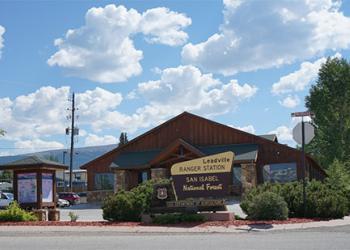
Address: 810 Front Street Leadville, CO 80461
Phone: 719-486-0749
Hours: 8:00 a.m. - 4:30 p.m. (Closed on federal holidays)
Getting There
Latitude / Longitude
Latitude: 39.15233375
Longitude: -106.41198448
Elevation
14,433 feet
Directions
South Mount Elbert Trail - From Leadville, Colorado, travel 15 miles south on U.S. Highway 24 to State Highway 82. Travel west 3.75 miles to Lake County Road 24 and turn right. Go north 1.5 miles to Shore Pretty Overlook. Four-wheel-drive vehicles can travel an additional 1.8 miles on Forest Service Road 125.B.
North Mount Elbert Trail - From Leadville, travel 3 miles south on U.S. Highway 24. Take State Highway 300 west 3/4 of a mile to Lake County Road 11. Follow signs to Elbert Creek Campground. The trailhead is just west on the south side of the road.
Facility and Amenity Information
Restrooms
Restrooms are not available at this site.
Water
Potable water is not available at this site.

