





Mount Harvard (Fourteener)
At 14,420 feet, Mount Harvard is the third highest peak in Colorado and one of the many peaks in the Collegiate Peaks Wilderness. A companion peak to Mount Columbia, Mount Harvard is accessible from North Cottonwood Trail, Pine Creek Trail, Frenchmen's Creek Trail, 3 Elk Creek Trail or Harvard Lakes Trailheads.
The most popular of these is North Cottonwood Trail/Horn Fork Basin Route, which is 6.5 miles long with a 4,400-foot elevation gain. From the trailhead, follow the North Cottonwood Trail west. At the Kroenke Lake/Horn Fork Basin junction, veer right towards Horn Fork Basin and Bear Lake. The climbing route cuts off prior to Bear Lake and ascends Mount Harvard's south slopes. Follow the cairned route to the summit. Descend along the same route.
Keep the following safety tips in mind:
- Mountain weather is unpredictable and can change quickly. Be prepared with rain gear and extra layers of warm clothing. Always check the weather forecast before heading out.
- Thunderstorms occur frequently in the afternoons, so plan your trip accordingly. Also, keep in mind that thunderstorms build rapidly, so keep an eye on the weather and get below timberline at the first sign of a thunderstorm. Follow these Lightening Safety Tips.
- Combat altitude sickness by acclimating gradually and staying hydrated. If symptoms (e.g., severe headache, dizziness or nausea) do occur, immediately descend to a lower elevation.
- At high altitudes, sunlight is much more intense, and the air is much drier. Wear sunscreen and a hat, and drink plenty of fluids. Always carry a map and compass, and know how to use them.
General Information
The Collegiate Peaks Wilderness was established in 1980 to preserve its quality, character and integrity. This area is intended to be a place where the imprint of humans is substantially unnoticed, natural processes are the primary influences, and human activity is limited to primitive recreation and minimum tools. Please follow Leave No Trace Outdoor Ethics to ensure that this and future generations experience this special place in its natural condition.
The U.S. Forest Service has many partners, including Colorado Fourteeners Initiative that help protect and preserve Colorado's 14,000-foot peaks, or "Fourteeners," through active stewardship and public education.
Commercial and organized groups must obtain a permit through the Leadville Ranger District in advance of their trip.
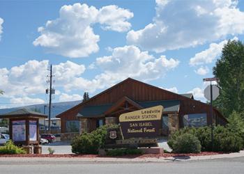
Address: 810 Front Street Leadville, CO 80461
Phone: 719-486-0749
Hours: 8:00 a.m. - 4:30 p.m. (Closed on federal holidays)
Getting There
Elevation
14,414 feet
Directions
From Leadville, Colorado, travel south on U.S. Highway 24 to Buena Vista. Then take Chaffee County Roads 350 and 365 west for 10 miles to the North Cottonwood Trailhead.
Facility and Amenity Information
Restrooms
Restroom information is not available for this site.
Water
Potable water is not available at this site.

